
User talk:Jespinos
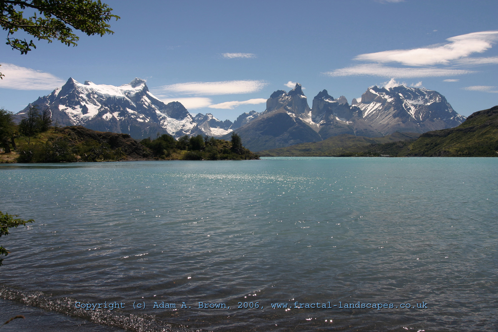
Tinquilco Lake
Thanks for the corrections to the photo license. I was at the lake two days ago. Have you ever been there? It's gorgeous. Tterrag 18:03, 2 November 2007 (UTC)
Sorry!
My Bad! I was just clicking every link from the Lampa page without actually registering what they were, sorry =(
Fitzroy border
Thank you for your information about the Fitzroy border.
The cited document mentions a 1:50,000 map. I have some accurate topographic maps of southern Chile, but these maps have many no data areas, and there are other areas, particularly around the border, for which I have not been able to get maps. For the Fitzroy area I have a tourist 1:50,000 map with no borders shown, but I have no Chilean maps. Also, I am trying to find out the exact elevation of Cerro San Valentin. Chilean mapping gives 3,911m but other sources give 4,058m and SRTM data supports the higher figure. Please see also Cordillera del Paine. I would like to have accurate elevations for these summits; official Chilean IGM maps show no elevations, and the most often given elevations, especially that of Paine Grande, are not compatible with photographic evidence. Any information you can supply would be greatly appreciated. Viewfinder 04:43, 7 August 2006 (UTC)
- I am an amateur in these matters. In any case, I can give you some useful info. See the following link: Summits in border zones. That is official info, although not necessarily true. Recent maps and the most of the Chilean websites give 4,058m for Cerro San Valentin. In relation to Paine Grande, almost all the sources give 3,050m. See this article:[1] and this another: Rolando Garibotti. Jespinos 23:23, 7 August 2006 (UTC)
Thank you for these interesting links. The Garibotti photo from Paine Grande summit is particularly interesting, despite the low resolution. Assuming it shows Fortaleza in the centre (I am sure about this, what else could it be?) and the Torres on the right, then the heights that the border zones link gives, PG 3050m, F 2681m, Torre Sur 2850m, cannot all be correct. Consider the geometry, if they were all correct, the Torres would appear higher than Fortaleza, which they clearly do not. I am not alone in claiming the Torres are only 2500m, see summitpost. It seems to me that the 2,850m Torre Sur elevation was estimated on the basis of 3,050m for Paine Grande, and that the 3050m claim is at the root of the other errors in the Paine range. You are right that this is given by almost all sources, but perhaps they all copy each other. Also, my ChIGM 1:50,000 map of Cerro Macá (section XI) has no summit elevation or topography, and SRTM clearly shows that it is no more than 2,300 m. The northern Chile data looks good; here the IGM maps are in excellent agreement with SRTM, but I think that some of the Patagonian summits are in need of a new, modern survey. Viewfinder 07:05, 8 August 2006 (UTC)
- Evidently, most are copies of data from a few sites or sources. It never pretended to be a proof of true elevation. Jespinos 20:14, 8 August 2006 (UTC)
- A French group that climbed the San Valentin in 1993 included two surveyors, who calculated an elevation of 4,080+-20 m by using a Global Positioning System (GPS). A Chilean group measured 4,070+-40 m by using GPS too.
- In the next photos, you can see the Cordillera del Paine from a different angle, near Monte Balmaceda. I calculate that Cerro Paine Grande is, approximately, at least 3 percent higher than Cerro Paine Chico and about of 30 percent higher than Cuerno Principal. What is your opinion?. Jespinos 02:07, 27 August 2006 (UTC)
Hi, thank you for these links. I have split and transferred this discussion to Monte San Valentin (which I have created) and Cordillera del Paine. Viewfinder 11:00, 27 August 2006 (UTC)
- I found information about Macá volcano. The Macá, according to the maps, has an elevation of 2,916 m, but the first ones and the second ones to climb it, consider that is not higher than 2,400-2,500 m. Jespinos 15:37, 14 September 2006 (UTC)
- Thank you for this link too. It shows that the elevations shown on many maps of Patagonia are often much too high. But the errors are not generally found on official ChIGM maps, which merely show no data areas. Interestingly, the above link gives over 1,913m for Volcan Burney, but SRTM and ChIGM mapping agree that it is about 1,500m. The quality of high resolution ChIGM topo maps is usually very good. Viewfinder 15:59, 14 September 2006 (UTC)
Hi. Looking at this, I was intrigued about the controversy over the listed heights of the Torres del Paine massif. I decided to measure from a photo of mine and with reference to the 1:100,000 scale tourist map that I got in Torres del Paine, the relative hights of the cuerno principal and paine grande. A smaller version of the image can be viewed at http://www.fractal-landscapes.co.uk/graphics/pictures/CL2005/1600/CPL3.jpg This was taken from the Hotel Explora beach viewpoint, which according to the maps is 14.1 km horizontally from the summit of the Cuerno Principal and 15.5 km from the summit of Paine Grande. Establishing the horizon line as the furthest visible extent of the lake (likely to be accurate to within 1 pixel, given the distance of 3 km to that shore), gave ratios of the tans of the angles of 490: 459 (Paine Grande: Cuerno Principal). This is assuming a planar projection, which is likely to be a very accurate approximation < 0.1% error. This gives a calculated height of 2598 m for the Cuerno Principal, which is within a single pixel quantisation error of the listed height of 2600, as given on the tourist map. Clearly, then, these peaks must be VERY CLOSE to this ratio of heights. By the same method, using the same map and photo, I established the distance to the Torre Central as 18.4 km, with a pixel height of 361. This gives a height for the Torre Central of only 2667 m, which is less than that listed on the Tourist map (which claims 2800). Given the consistency of the first two heights as a verification of the method, this means that the Torre Central is likely to be within a very small margin of error of this height, assuming 3050 for Paine Grande.
Sources of error:
Rotation of the image (less than 1 in 55 from true horizontal / vertical - from the line of the roof in the distance). Creates a maximum error of 27 pixels in the ratio of heights between Paine Grande and the Torre Central. {The true rotation appears unlikely to be more than 25% of this, from subjective observation.} Positional error on the tourist map, of the peaks and hotel. This is unlikely to be significant, because the map would have been made at the very least from a satellite or aerial photograph. Non-planar projection of the camera lens. This is also unlikely to be a significant source of error, because the lens is a high-quality aspherical sigma lens for an SLR, and not a compact camera lens. I've not observed any barrel distortion in images taken with it, which would indicate deviation from a planar projection. Horizon measurement error - this is less than tan (theta) = 1 / 1000 from the geography, which is sub-pixel accuracy.
-- The Ostrich
I beg to disagree with the above analysis, because it makes the assumption of 3050m for Paine Grande, which imo is a gross exaggeration. Viewfinder 13:39, 27 November 2006 (UTC)
Yeah. As I said above, the assumption was only to establish relative heights. The above analysis was flawed for several reasons, not least of which a) it neglected the height above sea level of Pehoe. b) It neglected the curvature of the earth, c) I mismeasured the distance to the cuerno Principal from the assumed site of the photo and d) the assumed site of the photo was incorrect. Fixing these discrepancies results in more reliable relative heights. See Viewfinder's talk page for a more complete analysis Viewfinder.
-- The Ostrich 19:40, 27 November 2006 (GMT)
Checkuser
If you think that someone is illicitly using a sockpuppet, including tag-teaming from an IP address, you can either bring the matter to WP:AN or Wikipedia:Requests for checkuser. Or you can ask him outright: were these edits yours? They may say "yes" (which really simplifies things). They may say "no", which means that if a later checkuser shows that the edits were theirs, then there is no doubt about deceptive intent.
By the way, you are clearly way above an en-1 level English-language writer. An en-1 is usually someone who can read, but cannot really express himself in English. I suggest you change your user page accordingly. - Jmabel | Talk 18:13, 25 September 2006 (UTC)
- My edits are not done in real time. For that reason, I think that my english level is not what it seems to be. I spent time, for example, comparing the number of results found by Google in the search for words or phrases, with the aim of reducing the number of errors in my edits. Please feel free to correct my spelling and grammatical errors. Jespinos 22:36, 27 September 2006 (UTC)
Check out this link:
The vatican link you spoke of:
calls her Teresa de Jesús "de los Andes" and then TERESA OF JESUS OF LOS ANDES. I'm pretty sure "the Andes" is a reference to the geography, and not the town. If you're really concerned about the article, I'd go rewrite it, because it is a pretty obvious {{copyvio}}. Cheers. --evrik 19:57, 6 October 2006 (UTC)
- I want to clarify that I'm not a specialist in this area, it is only my opinion. At the end of the Vatican page other saints are mentioned: Teresa of Ávila ( monastery of the Incarnation of the Carmelite nuns at Ávila), Thérèse de Lisieux (Carmelite monastery at Lisieux) and Saint Teresa Margaret Redi. If it was consistent, the name would be "Los Andes" for the town where the monastery is located. Jespinos 00:01, 7 October 2006 (UTC)
Thank you
Just a note to thank you for watching my user and talk pages, and de-vandalising them before I noticed the vandalism. Viewfinder 07:41, 24 October 2006 (UTC)
MANO DURA CON Al Vandalus QUIEN es sumamente hostil con Chile, se le nota el resentimiento a kilometros, debe ser habitante de alguno de los paises que nos rodean y envidian, o quiza un español que no puede entender que nos desarrollamos sin necesidad de mendigar dinero a la Union Europea, como lo hicieron ellos por mas de dos decadas.- saludos desde Puerto Montt.- Antarcticwik 04:54, 29 October 2006 (UTC)
- Tus intervenciones también han sido desafortunadas. Has caído en el juego de este personaje y has sido el mejor aliado en su causa. Te has ganado la enemistad de mucha gente que pudo haber ayudado a desenmascarar a esta persona. Por favor te pido que no sigas editando la página de Chile. Jespinos 15:48, 29 October 2006 (UTC)
Lo siento pero no puedo tener una actitud pasiva conun personaje que lo unico que hace es vandalizar los artículos sobre mí país. He tenido la oportunidad de conocer Perú y vivi en mexico 2 años. y son paises absolutamente diferentes a Chile. Vandalus con su propaganda constante trata de confundir a gente que no ha tenido la posibilidad de conocer in situ la realidad de los paises., y maliciosamente asimila a Chile con Estados como los recien nombrados.- Antarcticwik 23:15, 29 October 2006 (UTC)
Thanks for your recent work on Isla Navarino. Your level of English seems to me to be better than "Basic"! :-) -- Writtenonsand 20:35, 10 November 2006 (UTC)
- Thanks to you for your interest in articles about Chile. Jespinos 21:58, 10 November 2006 (UTC)
La proteccion de Chile
Es claro que siguio el "edit war" - y los dos lados violaron la regla 3RR. He reportado los dos a Wikipedia:Administrators'_noticeboard/3RR, y voy a pedir que se proteccione el articulo. Me frustra tanto AntarcticWik como Al-Andalus; el segundo abiertamente ha dicho que no le importa 3RR en este caso porque "es el vandalismo". No me importa cual lado tiene razon, pero te sugiero que hagas los cambios antes de que se cierre el articulo. Patstuart(talk)(contribs) 01:26, 13 November 2006 (UTC)
Chile with 58% of Poverty??
A 58% POVERTY? That Percentage is absolutely false, and is ILLOGICAL with a HDI OF 0.859 please they eliminate that information Antarcticwik 05:49, 13 November 2006 (UTC)
- La protección no implica necesariamente el respaldo a la edición actual. Tú eres uno de los causantes de esta situación y por lo tanto una de las personas con menos derecho a reclamar. Deberías tener una actitud más humilde. Jespinos 14:55, 13 November 2006 (UTC)
El unico causante del problema es Vandalus, yo solo me limitaba a proteger la pagina de ese vandalo. Además , tengo entendido que fuistes tú el encargado de corregir la última edición, la que tiene información falsa y tendenciosa en la sección de economía. Ademàs estoy sumamente molesto con la eliminacìón de las hermosas imagenes sobre geografía de Chile de la edición protegida. Antarcticwik 19:43, 13 November 2006 (UTC)
Laguna del Diamante
La imagen que cambiaste no era para nada la Laguna del Inca como vos decís. Vokoder 21:11, 19 November 2006 (UTC)
- De que Laguna del Inca me estas hablando. Según mi opinión, la cual no ha cambiado, la imagen corresponde a Laguna del Inca, Portillo, Chile. Busca en google "Laguna del Inca". Jespinos 22:21, 19 November 2006 (UTC)
- Bueno eso según tu opinión pero el que tomó la foto fue mi papá y jamás lo hizo en Chile y menos en una "Laguna" que se llama del "Inca". Vokoder 18:07, 20 November 2006 (UTC)
Puyehue (volcano)
Your photo caption for Puyehue (volcano) says "Eruption of Puyehue volcano, Chile, 1960". FYI, the GVP [[2]] contradicts that: "major eruptions in 1921-22 and 1960 sometimes attributed to Puyehue took place from Cordón Caulle volcano immediately to the NW" —The preceding unsigned comment was added by Ahtih (talk • contribs) 14:24, 5 December 2006 (UTC).
- You are right, please feel free to fix it. Jespinos 16:15, 5 December 2006 (UTC)
Award

Keep up the good work! - Darwinek 09:42, 14 December 2006 (UTC)
- Thank you.Jespinos 15:25, 14 December 2006 (UTC)
Merry Christmas

Hi! I just want to say Merry Christmas to you! Have a nice holiday time. - Darwinek 19:34, 21 December 2006 (UTC)
Chile town naming convention
Hi. I see you have edited several articles about towns in Chile. You may be interested to read and comment on the proposed naming convention for these articles. If you are aware of other interested editors or an appropriate noticeboard, please advise them too. Thanks. --Scott Davis Talk 13:01, 27 December 2006 (UTC)
Thanks, Jespinos, for creating the Regional notice page for Chile. I'm wondering if the list of edits for December could be updated automatically somehow. That would be a great way for anyone interested in Chile to keep on top of what's happening there. --JAXHERE | Talk 15:13, 28 December 2006 (UTC)
- Hi. I'm investigating it. Meanwhile, a work-around is use some of the special pages. For example: Special:Recentchangeslinked/Category:Chile_geography_stubs. Jespinos 16:07, 28 December 2006 (UTC)
GVP
Hello. I have contacted GVP staff several times in the past. We can use their data but they don't like if we just copy and paste whole text, and that is exactly what that vandal have done. So, no worries, use still GVP. Btw, we can use photos taken by scientists from Smithsonian Instituion as they are paid by the US government. See my contribution to El Valle (volcano) and the description of photo. - Darwinek 23:26, 27 January 2007 (UTC)
- I am now working on other stuff, making volcano articles now and then. Note that other photos found on GVP website taken by other sources than SI and USGS are not free and cannot be used. Btw, great job on covering Chile geography. Almost all national parks are created and many volcanoes, too. - Darwinek 10:14, 29 January 2007 (UTC)
Hi Jespinos. Thanks for the heads-up about the Miniques photo being Chiliques. We pulled out the original source of the photo (Volcanes de Chile, 1995, by Oscar Gonzalez-Ferran) and did some point-of-view maneuvering in Google Earth. It appears that you are correct, and the caption in the book was wrong. It will be fixed upon our next data update. - GVP Webmaster 14:34, 25 May 2007 (UTC)
Chile
Hola. The reason I reverted is because the information appeared to have a source. According to la Universidad de Talca, "Si bien étnicamente el pueblo chileno es mestizo, culturalmente posee un fuerte predominio de la cultura hispano europea, mayoritariamente católica." However, according to The CIA World Factbook, 95% of Chile is "white and white-Amerindian". Do you think we should add that as well? Khoikhoi 06:32, 25 February 2007 (UTC)
- I think you don't understand my point. I don't like making differences between whites and mestizos beyond the physical appearance. In my opinion both words would be excluded, at least of the main article. But the most important thing is that in the articles should not be insinuated a supposed mestizo inferiority, as occurs in the following cases:
- If you are reverting, you should begin with the latter, or at least give the true reasons for those sentences. Jespinos 21:41, 25 February 2007 (UTC)
Request for revision
I'm not aware if it's considered rude or just not right no ask for an article's revision, but there's no harm in trying. Could you please check my translation for Mount Tarn? Thanks.- Kilroytech 17:13, 4 April 2007 (UTC)
Invitation to WikiProject Chile
I see that you have made a lot of contributions realted to Chile, maybe you would like to join a WikiProject about Chile. I you are interested please sign HERE. Dentren | Talk 16:59, 12 April 2007 (UTC)
Problem with AlexBot searching Chile results
Hi Jespinos, one of the rules of the bot just added an article about Malolos, which has no relation with Chile, but I can't guess which rules is the problematic one, perhaps this issues will help us develop more sofisticated rules for this bot, can u help me with this? Kilroytech 21:29, 16 April 2007 (UTC)
Reverts
Thanks for your reverts on my userpage! ~ Giggy! Please leave your comments on my talk page, not yours. 00:23, 24 April 2007 (UTC)
Chile town naming convention poll
As it was not clear what most people support, I have opened a poll at Wikipedia talk:Chile-related regional notice board#settlement article naming poll. Please express your opinion there. it is important to have support of most people who will be affected. --Scott Davis Talk 13:03, 30 April 2007 (UTC)
RfA thanks
Hi Jespinos, thanks for your support in my RfA, which passed unopposed. Please let me know if I can be of any assistance. --Seattle Skier (talk) 19:28, 15 May 2007 (UTC)
Revision request: Valdivia, Chile
I have been working for a long time ith the Valdivia, Chile article, and I have expanded it a lot. I think it could soon be Good Article (GA), but first the article needs something like peer review, could you help to improve the article? Dentren | Talk 18:25, 20 July 2007 (UTC)
- In the Valdivia, Chile article i feel that some information is unneserarily repeated becuse Im not sure in whitch section it should be. I dont mean that all informetion can only be said once, I just want to make the article nice to read and keep everything on its topic. Maybe some of the sections of the article is unnesesary. I would like to have you opinion about:
- The economy section vs the last part of recent history - in whitch section should the recent history of the economy be?
- The economy section vs the last part of Independence and growt - in whitch section should tourism be?
- Prehispanic times vs Independe and growth - a cite of Charles Darwin is repeated because it is important to contrast his description of the landskape with early Spaniars one, but in whicht section should this comparison be made?
- Independence and growt vs German influences vs Education - Information about the German school apears in each of these sections.
- Independence and growt vs German influences - where goes the limit between culture and history, the things that are said in the history section could be said under German influnces and viceversa.
- Government and politics vs Ecological action - The CELCO case is named in both parts.
- Government and politics vs Culture vs Great Chilean Earthquake and Valdivia in Los Lagos Region - Where should the information about the creation of Los Ríos Region be placed? Dentren | Talk 09:01, 18 August 2007 (UTC)
Rivers and wikilinks
you are doing a good work when creating articles about rivers in Chile and adding citations about cathment ares. I created the list of rivers in Chile, maybe you could add to the list every new river that you create? It is important that new articles have pages that links to them, otherwise it is unlikely that somebody writes directly the name of the article (wikipedia.org/wiki/Bueno_River). Dentren | Talk 18:37, 10 August 2007 (UTC)
- I am aware of that page, but I prefer to add several wikilinks in a single edit. Also, I go to create some navigational boxes, which are very useful for solving, in part, the issue that you mentioned. For example, we can base on the following:Template:Alberta rivers and lakes. Jespinos 20:05, 10 August 2007 (UTC)
Following your suggestion I have now created 3 templates like this one {{Template:Araucanía Region rivers and lakes}}. I would like that every region had its own template. But some regions have to few or unknown or insigninfant water resources (Arica-Parinacota, Tarapacá, Antofagasta), sould they have a template? whicht regions should have a template? Or should there templates been organized by natural region better? Dentren | Talk 17:57, 7 September 2007 (UTC)
- I think we would do a template for Norte Grande and one for Norte Chico. For the rest, to group it by region. Jespinos 18:23, 7 September 2007 (UTC)
My description of the tsunami IS neutral - please read this message
I made some changes in the 1868 Tsunami part. I wrote:
On August 16, 1868, the Peruvian port of Arica was devastated by a tsunami which followed a magnitude 8.5 earthquake in the Peru-Bolivia Trench off the coast. The earthquake and tsunami killed an estimated 25,000 people in Arica and perhaps 70,000 people in all, this tsunami is well documented by press and photo. An officer of the US ship Wateree, L.G. Billings, who later became a rear admiral, in 1915 published a horrifying account of his experience as a witness of this earthquake in the Peruvian coast.[1]
This part of Arica's history belongs only to Peruvian history, since that port was then part of Peru. The account is completely neutral because there are no discrepancies in the text: - The text is completely accurate in historical terms. - The Tsunami affected only the Peru-Bolivia border, since it was barely detected in Cobija, thus it could not be felt in Chile. - The accounts of Admrl Billings describe very vividly the experience lived in that Peruvian port. The phrase "earthquake in the Peruvian coast" belongs to him.
The text was deleted by you. I find no reason for doing this, since the text is completely neutral and accurately describes the historical events. Please reconsider your decision. —The preceding unsigned comment was added by 200.37.120.18 (talk) 20:09, August 22, 2007 (UTC)
- It is tendentious and biased to repeat the info about the Peruvian sovereignty. The earthquake issue is used only as a excuse to include nationalistic text, it is only question of looking at your history on Wikipedia for proving this fact. To call Peru-Bolivia Trench to the Peru-Chile Trench is original research and blatant POV-pushing. Jespinos 22:36, 22 August 2007 (UTC)
Pumpa Luxsar
Because the S and W was not with Co-Ords and that's what most volcano articles use, see Template:VNUM. Black Tusk 22:15, 7 September 2007 (UTC)
- Sorry, I must have read it wrong. I have changed it back. Black Tusk 02:23, 8 September 2007 (UTC)
O'Higgins/San Martín Lake depth references
Thanks for joining the discussion at Talk:O'Higgins/San_Martín_Lake. I have replied there. Rupert Clayton (talk) 19:17, 20 December 2007 (UTC)