
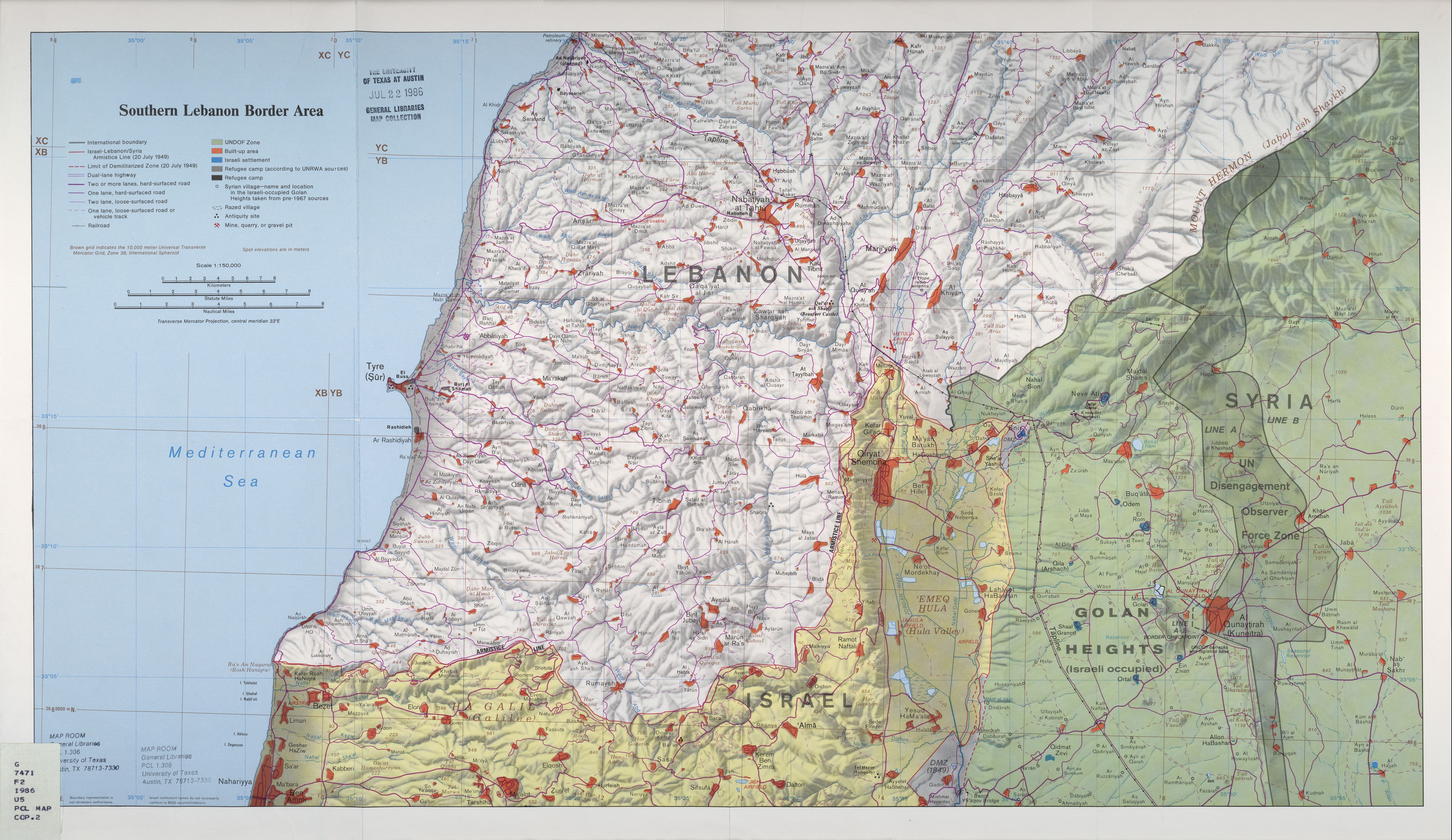
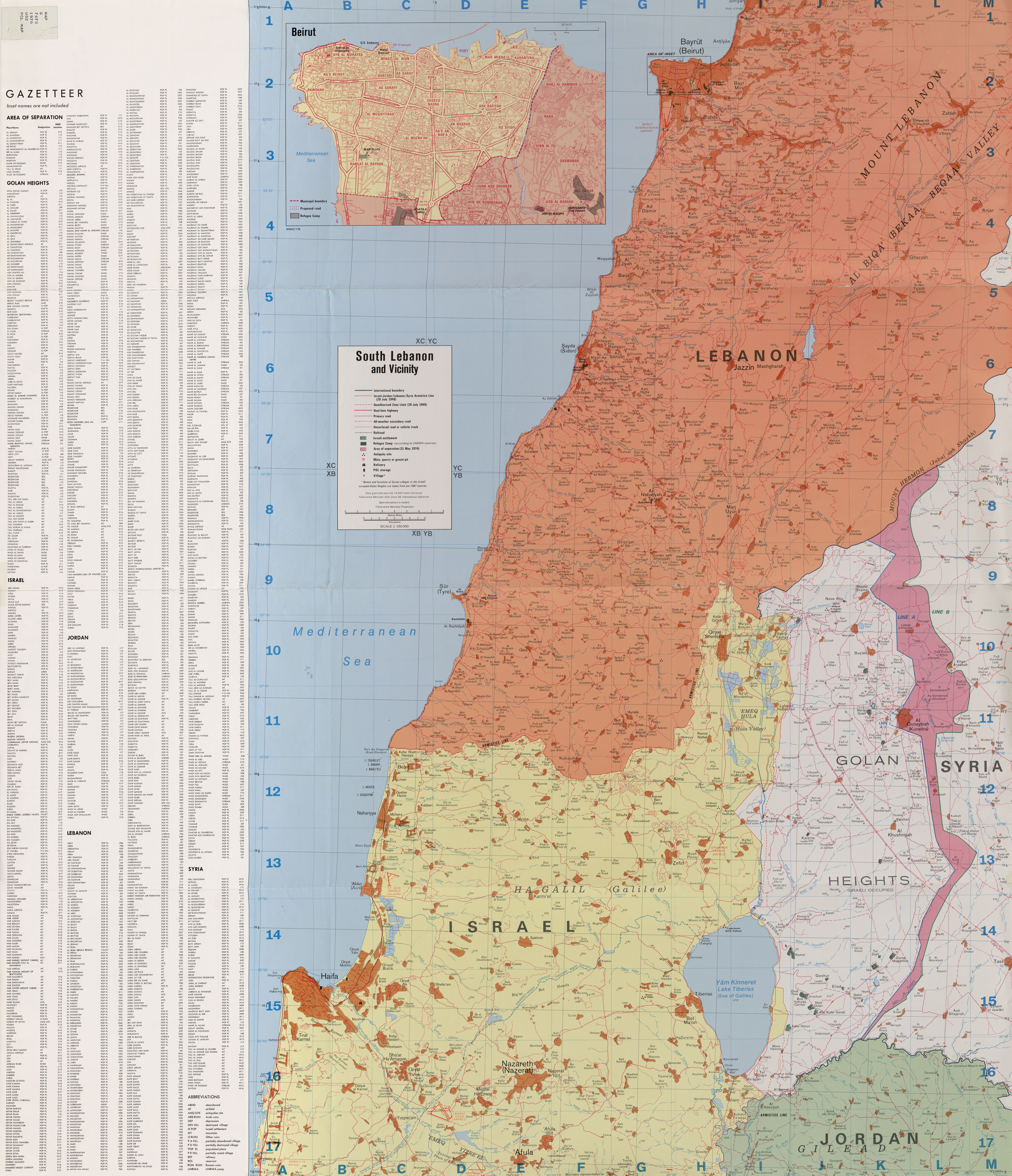
List of mountains in the Golan Heights
(Redirected from Mount Ram)
This is a list of mountains in the Golan Heights.
| Name | Height | Coordinates | Notes |
|---|---|---|---|
| Mount Hermon (Arabic: جبل الشيخ, Jabal el-Shaykh, Hebrew: הר חרמון, Har Hermon) | 2,814 metres (9,232 ft)[1] | 33°24′58″N 35°51′27″E / 33.41611°N 35.85750°E | Parts of Mount Hermon's southern slopes fall within the northern Golan Heights. |
| Mount Hermonit (Hebrew: הר חרמונית, Har Hermonit) | 1,216 metres (3,990 ft)[2] | An inactive volcano in the northern Golan Heights. | |
| Mount Baron (Hebrew: הר בראון, Har Baron) | 1,056 metres (3,465 ft)[3][4] | Part of an extinct volcano in the northeastern Golan Heights. | |
| Mount Hosek (Hebrew: הר חוזק, Har Hosek) | 1,158 metres (3,799 ft) | 33°03′14″N 35°51′01″E / 33.05389°N 35.85028°E | Part of an extinct volcano in the eastern Golan Heights. |
| Mount Ram (Hebrew: הר רם, Har Ram, lit. High Mountain) | 1,188 metres (3,898 ft)[5] | 33°14′43″N 35°47′02″E / 33.24528°N 35.78389°E | Part of an extinct volcano in the northern Golan Heights. |
| Mount Shifon (Hebrew: הר שיפון, Har Shifon) | 977 metres (3,205 ft)[6] | 33°04′10″N 35°46′08″E / 33.06944°N 35.76889°E | Part of an extinct volcano in the northeastern the Golan Heights. |
| Mount Odem/Ras al-Ahmar (Hebrew: הר אודם, Har Odem, lit. Ruby Mountain, Arabic: رأس الأحمر, Ras al-Ahmar) | 1,100 metres (3,600 ft) | 33°11′55″N 35°45′15″E / 33.19861°N 35.75417°E | Part of an extinct volcano in the northern Golan Heights. |
| Tall al-Faras/Mount Peres (Arabic: تل الفرس, Tall al-Faras, Hebrew: הר פרס, Har Peres) | 929 metres (3,048 ft)[4][7] | 32°57′34″N 35°51′50″E / 32.95944°N 35.86389°E | Volcanic mountain located in central Golan Heights. |
| Mount Avital/Tall Abu an Nada (Hebrew: הר אביטל, Har Avital, Arabic: تل أبو الندى, Tall Abu an Nada) | 1,204 metres (3,950 ft)[4][7] | 33°06′38″N 35°47′45″E / 33.11056°N 35.79583°E | Part of an extinct volcano in the northeastern Golan Heights. |
| Mount Bental/Tal Al-Gharam (Hebrew: הר בנטל, Har Bental, Arabic: تل الغرام, Tal Al-Gharam) | 1,171 metres (3,842 ft) | 33°07′45″N 35°47′09″E / 33.12917°N 35.78583°E | Part of an extinct volcano in the northeastern Golan Heights. |
| Mount Bnei Rasan/Tall al Ghassaniyah (Hebrew: הר בני רסן, Har Bnei Rasan, Arabic: تلّ الغسانية, Tall al Ghassaniyah) | 1,072 metres (3,517 ft)[3][4][7] | 33°04′49″N 35°50′04″E / 33.08028°N 35.83444°E | Part of an extinct volcano in the eastern Golan Heights. Atop the mountain is the Golan Heights Wind Farm. |
| Tall al Makhfi (Arabic: تل المخفي, Tall al Makhfi) | 1,055 metres (3,461 ft)[3][4][7] | 33°08′0″N 35°48′0″E / 33.13333°N 35.80000°E | Mountain in the northeastern Golan Heights, north of Quneitra. |
| Mount Varda/Tall Wardah (Hebrew: הר ורדה, Har Varda, lit. Rose Mountain, Arabic: تل وردة, Tall Wardah) | 1,226 metres (4,022 ft)[3][4][7] | 33°12′40″N 35°47′20″E / 33.21111°N 35.78889°E | Part of an extinct volcano in the northern Golan Heights. |
| Mount Yosifon/Tall Yusuf (Hebrew: הר יוסיפון, Har Yosifon, Arabic: تل يوسف, Tall Yusuf) | 981 metres (3,219 ft)[3][4][7] | 33°03′24″N 35°47′49″E / 33.05667°N 35.79694°E | Part of an extinct volcano in the central Golan Heights. |
| Mount Hermonit/Tell al-Sheikh (Hebrew: הר חרמונית, Har Hermonit, Arabic: تل الشيخ, Tell al-Sheikh) | 1,211 metres (3,973 ft)[3][4][7] | 33°10′55″N 35°47′39″E / 33.18194°N 35.79417°E | Part of an extinct volcano in the northern Golan Heights. |
| Givat Orha/Tel Jukhdar (Hebrew: גבעת אורחה, Givat Orha, Arabic: تل جوخدار, Tel Jukhdar) | 646 metres (2,119 ft)[8] | 32°55′39″N 35°51′09″E / 32.92750°N 35.85250°E | Hill in southeastern Golan Heights. |
| Mount Kramim/Tell Sader al-Arus (Hebrew: הר כרמים, Har Kramim, lit. Vineyards Mountain, Arabic: تل صدر العروس, Tell Sader al-Arus) | 1,198 metres (3,930 ft)[9] | 33°13′06″N 35°46′32″E / 33.21833°N 35.77556°E | Part of an extinct volcano in northern Golan Heights. |
| Tell Saki (Hebrew: תל א-סאקי, Tell a-Saki, Arabic: تل الساقي), Tell al-Saki) | 594 metres (1,949 ft) | 32°51′58″N 35°49′50″E / 32.86611°N 35.83056°E | Small extinct volcano in southern Golan Heights. |
Pictures[edit]
-
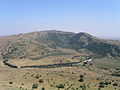
 Mount Peres/Tall al-Faras
 -
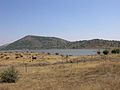
 Mount Avital/Tall Abu an Nada
 -
 Mount Bental/Tal Al-Gharam
 -
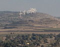 Mount Bnei Rasan/Tall al Ghassaniyah
 -
 Mount Yosifon/Tall Yusuf
 -
 Givat Orha/Tel Jukhdar
 -
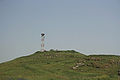
 Mount Hosek


References[edit]
- ^ "middle-east-online.com". Archived from the original on 2007-12-24. Retrieved 2010-04-24.
- ^ "Mount Hermonit".
- ^ a b c d e f Southern Lebanon Border Area 1986
- ^ a b c d e f g h South Lebanon and Vicinity 1976
- ^ Mount Ram - Israel and Syria: peace and security on the Golan
- ^ Mount Shifon - Israel and Syria: peace and security on the Golan p. 105.
- ^ a b c d e f g Golan Heights and vicinity 1994
- ^ kkl.org.il
- ^ Tell Sader al-Arus/Mount Kramim - Israel and Syria: peace and security on the Golan