
Mount Tenakourou
| Mount Tenakourou | |
|---|---|
 stones at the top of the Tenakourou | |
| Highest point | |
| Elevation | 747 m (2,451 ft)[1] |
| Listing | Country high point |
| Geography | |
 Mount Tenakourou Location in Burkina Faso (on the border with Mali) | |
| Location | |
| Geology | |
| Mountain type | Hill |
Mount Tenakourou is the highest point in the west-African nation of Burkina Faso. It is a hill located on the border of the Cascades Region of Burkina Faso and the Sikasso Region of the country of Mali. Tenakourou has an elevation of 747 metres (2,451 ft).
-
 A hut near the summit of Tenakourou
 -
 Stones at the top of the Tenakourou
 -
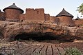 Village on the side of Mount Tenakourou


References
- ^ "Téna Kourou" on Peakbagger.com Retrieved 30 September 2011
This Mali location article is a stub. You can help Wikipedia by expanding it. |
This Burkina Faso location article is a stub. You can help Wikipedia by expanding it. |