Municipality of Gornji Grad
Municipality of Gornji Grad
Občina Gornji Grad | |
|---|---|
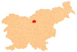
 Location of the Municipality of Gornji Grad in Slovenia | |
| Coordinates: 46°18′N 14°48′E / 46.300°N 14.800°E | |
| Country | |
| Government | |
| • Mayor | Stanko Ogradi |
| Area | |
| • Total | 90.1 km2 (34.8 sq mi) |
| Population (2002)[1] | |
| • Total | 2,595 |
| • Density | 29/km2 (75/sq mi) |
| Time zone | UTC+01 (CET) |
| • Summer (DST) | UTC+02 (CEST) |
The Municipality of Gornji Grad (pronounced [ˈɡoːɾnji ˈɡɾaːt] ⓘ; Slovene: Občina Gornji Grad) is a municipality in Slovenia. The seat of the municipality is the town of Gornji Grad. It lies on the Dreta River in the foothills of the Savinja Alps. Traditionally it belonged to the region of Styria and it is now included in the Savinja Statistical Region.[2]
References
External links
Wikimedia Commons has media related to Municipality of Gornji Grad.

