Myōgi-Arafune-Saku Kōgen Quasi-National Park
Appearance
| Myōgi-Arafune-Saku Kōgen Quasi-National Park | |
|---|---|
| 妙義荒船佐久高原国定公園 | |
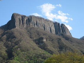
 Mount Arafune (1,423 m) | |
 | |
| Location | Gunma/Nagano Prefecture, Japan |
| Area | 131.23 km2 |
| Established | 10 April 1969 |
Myōgi-Arafune-Saku Kōgen Quasi-National Park (妙義荒船佐久高原国定公園, Myōgi-Arafune-Saku Kōgen Kokutei Kōen) is a Quasi-National Park on the borders of Gunma and Nagano Prefectures, Japan. Established in 1969, the central feature of the park are Mounts Arafune (荒船山) (1,423 m) and Myōgi (1,104 m).[1][2]
Related municipalities
- Gunma: Annaka, Nanmoku, Shimonita, Tomioka, Ueno[3]
- Nagano: Karuizawa, Kitaaiki, Miyota, Saku, Sakuho[4]
See also
Wikimedia Commons has media related to Myogi-Arafune-Sakukogen Quasi-National Park.
References
- ^ "鳥海/越後三山只見/水郷筑波/妙義荒船佐久高原". Natural Parks Foundation. Retrieved 25 April 2012.
- ^ "List of Quasi-National Parks" (PDF). Ministry of the Environment. Retrieved 25 April 2012.
- ^ "妙義荒船佐久高原国定公園". Gunma Prefecture. Retrieved 25 April 2012.
- ^ "資料編 (p. 88)" (PDF). Nagano Prefecture. Retrieved 25 April 2012.
36°12′N 138°42′E / 36.200°N 138.700°E
