
Natural arch

A natural arch or natural bridge is a natural geological formation where a rock arch forms, with an opening underneath. Most natural arches form as a narrow ridge, walled by cliffs, become narrower from erosion, with a softer rock stratum under the cliff-forming stratum gradually eroding out until the rock shelters thus formed meet underneath the ridge, thus forming the arch. Natural arches commonly form where cliffs are subject to erosion from the sea, rivers or weathering (subaerial processes); the processes "find" weaknesses in rocks and work on them, making them larger until they break through.
The choice between bridge and arch is somewhat arbitrary. The Natural Arch and Bridge Society identifies a bridge as a subtype of arch that is primarily water-formed.[1] By contrast, the Dictionary of Geological Terms defines a natural bridge as a "natural arch that spans a valley of erosion." [2]
Coastline
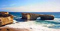
On coasts two different types of arches can form depending on the geology. On discordant coastlines rock types run at 90° to the coast. Wave refraction concentrates the wave energy on the headland, and an arch forms when caves break through the headland, e.g., London Bridge in (Victoria, Australia). When these eventually collapse, they form stacks and stumps. On concordant coastlines rock types run parallel to the coastline, with weak rock (such as shale) protected by stronger rock (such as limestone) the wave action breaks through the strong rock and then erodes the weak rock very quickly. Good examples of this are at Durdle Door and Stair Hole near Lulworth Cove on the Dorset Jurassic Coast in south England, although these are on an area of concordant coastline. When Stair Hole eventually collapses, it will form a cove.
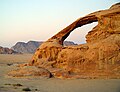
Weather-eroded arches
- Deep cracks penetrate into a sandstone layer.
- Erosion wears away exposed rock layers and enlarges the surface cracks, isolating narrow sandstone walls, or fins.
- Alternating frosts and thawing cause crumbling and flaking of the porous sandstone and eventually cut through some of the fins.
- The resulting holes become enlarged to arch proportions by rockfalls and weathering. Arches eventually collapse, leaving only buttresses that in time will erode.[3]
- Many of these arches are found within Arches National Park and Rainbow Bridge National Monument in Utah.
Water-eroded arches

Some natural bridges may look like arches, but they form in the path of streams that wear away and penetrate the rock. Pothole arches form by chemical weathering as water collects in natural depressions and eventually cuts through to the layer below.
Natural Bridges National Monument in Utah is another area to view several natural bridges.
Cave erosion
Natural bridges can form from natural limestone caves, where paired sinkholes collapse and a ridge of stone is left standing in between, with the cave passageway connecting from sinkhole to sinkhole.
Like all rock formations, natural bridges are subject to continued erosion, and will eventually collapse and disappear. One example of this was the double-arched Victorian coastal rock formation, London Bridge, which lost an arch after storms increased erosion.[4]
Arches as highways
In a few places in the world, natural arches are truly natural bridges because there are roads running across them. Two such arches are found in Kentucky. One, a cave erosion arch made of limestone is located in Carter Caves State Park and it has a paved road on top. Another, a weather-eroded sandstone arch with a dirt road on top is located on the edge of Natural Bridge State Resort Park in Kentucky. It is called White's Branch Arch (also known as the Narrows) and the road going over it is usually referred to as the Narrows Road.
The third one is found in Ponoarele village, in Romania. It is 60 m long, 13 m wide, features a stone arch 4 m thick, 20 m high, with a 9 m span. It is called God's Bridge (Podul lui Dumnezeu) and it is the only one in the world effectively used for traffic.
Gallery
-
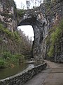 Natural Bridge National Historic Landmark in Virginia, United States.
 -
-
-
 Pont d'Arc arch in Southern France.
 -
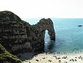 Durdle Door on the Dorset coast, United Kingdom.
 -
-
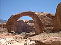
 The Arch of Cabo San Lucas in Mexico.
 -

-
-

-
 Pravčická brána in Bohemian Switzerland, Czech Republic.
 -
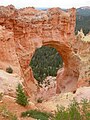 Natural Bridge at Bryce Canyon National Park, Utah, United States.
 -
-
 The "Sea Lion" arch and Sleeping Giant (Ontario) on the shoreline of Lake Superior. The arch was formed by wave action on the Diabase dike.


.JPG)


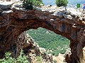
Notable natural arches
 Anacapa Island, Channel Islands National Park, California, USA
- Arch Creek Historic and Archeological Site, Florida, USA
- Arches National Park, Utah, USA
- Ayres Natural Bridge State Park, Wyoming, USA
 Azure Window, Gozo, Malta
- Bryce Canyon National Park, Utah, USA
 Castell de Castells, Spain
- Creelsboro Natural Bridge, Kentucky, USA
 El Arco de Cabo San Lucas, Mexico
 Engetsu-tō, Shirahama, Wakayama, Japan
 Étretat, France
 God's bridge, Ponoarele, Mehedinţi, Romania
- Goat Rock Beach, California, USA
- Grosvenor Arch, Utah, USA
- Kolob Arch, Utah, USA
 Llanrhaeadr-ym-Mochnant, Wales, UK
- Natural Bridge, Alabama, USA
- Natural Bridge Caverns, Texas, USA
- Natural Bridge State Park, Kentucky, USA
- Natural Bridge State Park, Massachusetts, USA
- Natural Bridge, Virginia, USA
- Natural Bridges National Monument, Utah, USA
- Natural Bridges State Beach, California, USA
 Natural Arch, Tirumala hills - Tirumala, India
 Hazarchishma Natural Bridge, Bamiyan, Afghanistan
 Parque Nacional de Sete Cidades, Brazil
 Percé Rock, Quebec, Canada
- Pont d'Arc, France
 Pravčická brána, Czech Republic
- Punarjani Guha - natural tunnel, India
 Rainbow Cave (actually an arch) in the Galilee
 Jebel Kharaz (Jordan)
- Rattlesnake Canyon, Colorado, USA
- Rock Bridge of Gulanchwadi, Narayangaon Maharashtra, India[5]
- Senkanmatsu-shima, Iwami, Tottori, Japan
- Sewanee Natural Bridge, Tennessee, USA
 Shipton's Arch, Xinjiang, China
 Springbrook National Park, Queensland, Australia
 Tassili n'Ajjer - National Park in Algeria with many arches
- Tonto Natural Bridge, Arizona, USA
 Tukuyu natural bridge, Tanzania
See also
References
- ^ Natural Arch and Bridge Society, FAQ.
- ^ American Geological Institute, Dictionary of Geological Terms, 1976, Doubleday Anchor
- ^ http://www.nature.nps.gov/geology/parks/arch/
- ^ Trek Earth
- ^ Offbeat Tracks in Maharashtra - A Travel Guide - Book by Milind Gunaji ISBN 81-7154-669-2