
Ose, Norway
Ose | |
|---|---|
Village | |
 View of the Storståga in Ose, the timber building is used for various exhibitions. | |
 Ose Location of the village  Ose Ose (Norway) | |
| Coordinates: 58°57′01″N 7°40′47″E / 58.9503°N 07.6798°E | |
| Country | Norway |
| Region | Southern Norway |
| County | Agder |
| District | Setesdal |
| Municipality | Bygland |
| Elevation | 210 m (690 ft) |
| Time zone | UTC+01:00 (CET) |
| • Summer (DST) | UTC+02:00 (CEST) |
| Post Code | 4745 Bygland |
Ose is a village in Bygland municipality in Agder county, Norway. The village is located along the river Otra, just north of the lake Åraksfjorden. The Norwegian National Road 9 runs through the village. Just across the river to the north lies the village of Austad, and about 1.5 kilometres (0.93 mi) to the north along Highway 9 lies the village of Moi.
The Reiårsfossen waterfall lies about 1 kilometre (0.62 mi) to the south. The area just southeast of the waterfall is the site of Reiårsfossen Camping, which is also the location of the Ose Country Music festival.[2] There is a traditionally-built log building in Ose called Storståga, which is used for various exhibitions.
The SS Bjoren is a wood-fuelled heritage steamboat that travels the route between Byglandsfjord-Bygland-Ose across the lake Byglandsfjorden and Åraksfjorden each summer.
Media gallery[edit]
-
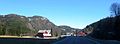 View of Ose village
 -
 View of Ose village
 -
 View of the nearby Reiårsfossen waterfall
 -
 Ose Country Music Festival
 -
 Ose bridge, just south of the village, crossing the river Otra


References[edit]
- ^ "Ose, Bygland (Aust-Agder)". yr.no. Retrieved 23 April 2017.
- ^ "Ose Country Festival". Archived from the original on 4 March 2016. Retrieved 21 March 2012.
This Agder location article is a stub. You can help Wikipedia by expanding it. |