
Corund
Corund
Korond | |
|---|---|
 | |
 Coat of arms | |
 Location in Harghita County | |
 Corund Location in Romania | |
| Coordinates: 46°28′N 25°11′E / 46.467°N 25.183°E | |
| Country | Romania |
| County | Harghita |
| Government | |
| • Mayor (2020–2024) | Mihály Katona[1] (UDMR) |
| Area | 113.51 km2 (43.83 sq mi) |
| Population (2021-12-01)[2] | 6,394 |
| • Density | 56/km2 (150/sq mi) |
| Time zone | EET/EEST (UTC+2/+3) |
| Postal code | 537060 |
| Area code | +40 266 |
| Vehicle reg. | HR |
| Website | www |
Corund (Hungarian: Korond, Hungarian pronunciation: [ˈkorond] ) is a commune in Harghita County, Romania. It lies in the Székely Land, an ethno-cultural region in eastern Transylvania, in the "Salt Region" (Ținutul Sării or Sóvidék), and is formed of five villages: Atia (Atyha), Calonda (Kalonda), Corund (Korond), Fântâna Brazilor (Fenyőkút), and Valea lui Pavel (Pálpataka).
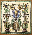
While the village of Corund is renowned for its pottery and ceramics, the village of Atia is on the route of the Via Transilvanica long-distance trail.[3]
Governance[edit]

The village historically formed part of the Székely Land region of Transylvania province. It belonged to Udvarhelyszék, then, from 1876 until 1918, to Udvarhely County in the Kingdom of Hungary. After World War I, by the terms of the Treaty of Trianon of 1920, it became part of Romania. As a result of the Second Vienna Award, it was ceded to Hungary between 1940 and 1944. After World War II, it came under Romanian administration and became part of Romania in 1947. Between 1952 and 1960, it formed part of the Hungarian Autonomous Province, then, of the Mureș-Hungarian Autonomous Province until it was abolished in 1968. Since then, the commune has been part of Harghita County.
Demographics[edit]
At the 2011 census, the commune had a population of 6,135; out of them, 94% were Hungarian, 2.6% were Roma and 0.3% were Romanian.[4]
Gallery[edit]
-
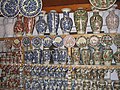 Korond pottery
 -
 Korond plate
 -
 Stove tile


References[edit]
- ^ "Results of the 2020 local elections". Central Electoral Bureau. Retrieved 9 June 2021.
- ^ "Populaţia rezidentă după grupa de vârstă, pe județe și municipii, orașe, comune, la 1 decembrie 2021" (XLS). National Institute of Statistics.
- ^ "Terra Siculorum | Via Transilvanica". www.viatransilvanica.com. Retrieved 10 August 2023.
- ^ Tab8. Populaţia stabilă după etnie – judeţe, municipii, oraşe, comune, 2011 census results, Institutul Național de Statistică, accessed 20 February 2020.

This Harghita County location article is a stub. You can help Wikipedia by expanding it. |