Jump to content

Pola de Laviana

Coordinates: 43°14′42″N 5°33′43″W / 43.24500°N 5.56194°W / 43.24500; -5.56194
From Wikipedia, the free encyclopedia

This is an old revision of this page, as edited by Addbot (talk | contribs) at 07:16, 1 March 2013 (Bot: Migrating 4 interwiki links, now provided by Wikidata on d:q1018052). The present address (URL) is a permanent link to this revision, which may differ significantly from the current revision.

Pola de Laviana
Map
CountrySpain
Autonomous communityAsturias
ProvinceAsturias
MunicipalityLaviana
Population
 (2011)
 • Total
9,106
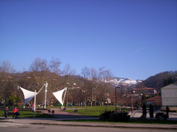
Park in Pola de Laviana

Pola de Laviana is one of nine parishes (administrative divisions) in Laviana, a municipality within the province and autonomous community of Asturias, in northern Spain.

43°14′42″N 5°33′43″W / 43.24500°N 5.56194°W / 43.24500; -5.56194

Villages

  • Pola de Laviana
  • Las Portillas
  • Quinta Norte
  • Quinta Sur
  • La Rasa
  • La Rebollada
  • Rebolloso
  • Sertera
  • Canto de Abajo
  • Canto de Arriba
  • La Carba
  • Casapapio
  • Castanal
  • El Castrillon
  • Felgueron
  • Sospelaya
  • Abajo Valdelasabejas
  • Carba de las Llanas
  • La Chalana
  • Horron de Arriba
  • Llancuervo
  • El Lloson
  • Omedines
  • Las Llanas
  • Lloreo
  • Ortigosa
  • Pielgos
  • Piniella
  • Otero Sur
  • Pando
  • El Robledal
  • Solavelea
  • La Traviesa
  • Valdelasabejas-Arriba
  • Vallebregon
  • Tirana

References