Przydonica
Przydonica | |
|---|---|
Village | |
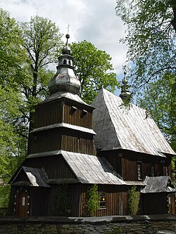
 Our Lady of Consolation’s parish church in Przydonica | |
| Country | |
| Voivodeship | Lesser Poland |
| County | Nowy Sącz County |
| Gmina | Gródek nad Dunajcem |
| Population | |
• Total | 18 |
Przydonica [pʂɨdɔˈɲit͡sa] is a village in the administrative district of Gmina Gródek nad Dunajcem, within Nowy Sącz County, Lesser Poland Voivodeship, in southern Poland. The namesake of "our Lady of Prydonic" It lies 14 kilometres (9 mi) north-east of Nowy Sącz and 71 km (44 mi) south-east of the regional capital Kraków.[1] Not to be confused with the nearby and more populous, Przydonica-Glinik
Church
The parish church dates back to the sixteenth century,[2] and houses Our Lady of Przydonica, one of three such. King John III Sobieski proclaimed a miracle when he saw a vision of the Virgin Mary after a 1683 military victory in Vienna against the Turks.
Commerce
The village hosts a sawmill and a general merchandise market[1]
References
- ^ a b "Central Statistical Office (GUS) – TERYT (National Register of Territorial Land Apportionment Journal)" (in Polish). 2008-06-01. Cite error: The named reference "TERYT" was defined multiple times with different content (see the help page).
- ^
["http://books.google.com/books?ei=BHG3S-mFM4ziNfXYieIL&ct=result&id=PtBZAAAAIAAJ&dq=Przydonica&q=Przydonica#search_anchor" "Instytut Sztuki (Polska Akademia Nauk)"]. Polish art studies. Wrocław: Zakład Narodowy im. Ossolińskich.: 56 1979. Retrieved April 3, 2010.
{{cite journal}}: Check|url=value (help)
External links
49°44′N 20°47′E / 49.733°N 20.783°E
