
Shoreacres, Texas
Shoreacres, Texas | |
|---|---|
 Location in Harris County and the state of Texas | |
| Coordinates: 29°37′13″N 95°1′0″W / 29.62028°N 95.01667°W | |
| Country | United States |
| State | Texas |
| Counties | Chambers, Harris |
| Area | |
| • Total | 0.96 sq mi (2.49 km2) |
| • Land | 0.91 sq mi (2.35 km2) |
| • Water | 0.06 sq mi (0.14 km2) |
| Elevation | 10 ft (3 m) |
| Population (2020) | |
| • Total | 1,566 |
| • Density | 1,758.28/sq mi (679.01/km2) |
| Time zone | UTC-6 (Central (CST)) |
| • Summer (DST) | UTC-5 (CDT) |
| ZIP code | 77571 |
| Area code | 281 |
| FIPS code | 48-67688[2] |
| GNIS feature ID | 1347090[3] |
| Website | www |
Shoreacres is a city located in Harris County in the U.S. state of Texas alongside State Highway 146. Established with a mayor-alderman form of city government, it was incorporated in 1949.[4] The population was 1,566 at the 2020 census.[5]
Geography[edit]

Shoreacres is located at 29°37′13″N 95°1′0″W / 29.62028°N 95.01667°W (29.620395, –95.016710).[6]
According to the United States Census Bureau, the city has a total area of 0.97 square miles (2.5 km2), of which 0.93 square miles (2.4 km2) is land and 0.039 square miles (0.1 km2), or 5.86%, is water.[7]

Demographics[edit]
| Census | Pop. | Note | %± |
|---|---|---|---|
| 1950 | 183 | — | |
| 1960 | 518 | 183.1% | |
| 1970 | 1,872 | 261.4% | |
| 1980 | 1,260 | −32.7% | |
| 1990 | 1,316 | 4.4% | |
| 2000 | 1,488 | 13.1% | |
| 2010 | 1,493 | 0.3% | |
| 2020 | 1,566 | 4.9% | |
| U.S. Decennial Census[8] | |||
| Race | Number | Percentage |
|---|---|---|
| White (NH) | 1,113 | 71.07% |
| Black or African American (NH) | 27 | 1.72% |
| Native American or Alaska Native (NH) | 15 | 0.96% |
| Asian (NH) | 16 | 1.02% |
| Some Other Race (NH) | 10 | 0.64% |
| Mixed/Multi-Racial (NH) | 54 | 3.45% |
| Hispanic or Latino | 331 | 21.14% |
| Total | 1,566 |
As of the 2020 United States census, there were 1,566 people, 570 households, and 366 families residing in the city.
As of the census[2] of 2000, there were 1,488 people, 559 households, and 455 families residing in the city. The population density was 1,656.1 inhabitants per square mile (639.4/km2). There were 594 housing units at an average density of 661.1 per square mile (255.3/km2). The racial makeup of the city was 94.15% White, 1.01% African American, 0.07% Native American, 0.94% Asian, 0.07% Pacific Islander, 2.96% from other races, and 0.81% from two or more races. Hispanic or Latino of any race were 7.66% of the population.
There were 559 households, out of which 32.2% had children under the age of 18 living with them, 72.1% were married couples living together, 5.9% had a female householder with no husband present, and 18.6% were non-families. 15.6% of all households were made up of individuals, and 7.3% had someone living alone who was 65 years of age or older. The average household size was 2.66 and the average family size was 2.96.
In the city, the population was spread out, with 23.9% under the age of 18, 6.0% from 18 to 24, 28.2% from 25 to 44, 30.4% from 45 to 64, and 11.4% who were 65 years of age or older. The median age was 41 years. For every 100 females, there were 102.2 males. For every 100 females age 18 and over, there were 100.4 males.
The median income for a household in the city was $71,985, and the median income for a family was $75,941. Males had a median income of $51,523 versus $31,389 for females. The per capita income for the city was $29,370. About 1.1% of families and 1.8% of the population were below the poverty line, including 0.5% of those under age 18 and 2.8% of those age 65 or over.
Education[edit]
Shoreacres is within the La Porte Independent School District and is zoned to:[12] Bayshore Elementary School, La Porte Junior High School,[13] and La Porte High School.
Residents of La Porte ISD (and therefore Shoreacres) are zoned to San Jacinto College.[14]
Government[edit]
Shoreacres is governed by a five-member City Council under the city manager form of government as adopted under ORDINANCE No. 2017-266 that was approved by city council June 12, 2017. The current City Manager is Troy D. Harrison, Sr.. The current Mayor is David Jennings (term ends 2020). Council consists of five at-large Alderpersons including Mayor Pro-Tempore Ricky Bowles (term ends 2020), Bo Bunker (term ends 2021), Jerome McKown (term ends 2019), Neil Moyer (term ends 2020) and Felicia Ramos (term ends 2021). Council members serve staggered two-year terms.
The city provides police, recycling, parks, planning, zoning, floodplain management, and building code inspections among its services. The city provides fire, sanitation, and emergency medical services by contract.
Harris Health System (formerly Harris County Hospital District) designated Strawberry Health Center in Pasadena for ZIP code 77571. The nearest public hospital is Ben Taub General Hospital in the Texas Medical Center.[15]
Effects of Hurricane Ike, 2008[edit]
On September 13, Hurricane Ike made landfall near Galveston,[16] with 88 percent of the homes in Shoreacres suffering flood damage.[17] No local deaths were reported.[17]
Transportation[edit]
Harris County Transit operates public transportation.[18]
See also[edit]
History of the Galveston Bay Area
References[edit]
- ^ "2019 U.S. Gazetteer Files". United States Census Bureau. Retrieved August 7, 2020.
- ^ a b "U.S. Census website". United States Census Bureau. Retrieved January 31, 2008.
- ^ "US Board on Geographic Names". United States Geological Survey. October 25, 2007. Retrieved January 31, 2008.
- ^ TSHA Online - Texas State Historical Association
- ^ "Profile of General Population and Housing Characteristics: 2010 Demographic Profile Data (DP-1): Shoreacres city, Texas". United States Census Bureau. Retrieved June 15, 2012.
- ^ "US Gazetteer files: 2010, 2000, and 1990". United States Census Bureau. February 12, 2011. Retrieved April 23, 2011.
- ^ "Geographic Identifiers: 2010 Demographic Profile Data (G001): Shoreacres city, Texas". United States Census Bureau. Retrieved June 15, 2012.
- ^ "Census of Population and Housing". Census.gov. Retrieved June 4, 2015.
- ^ "Explore Census Data". data.census.gov. Retrieved May 22, 2022.
- ^ https://www.census.gov/ [not specific enough to verify]
- ^ "About the Hispanic Population and its Origin". www.census.gov. Retrieved May 18, 2022.
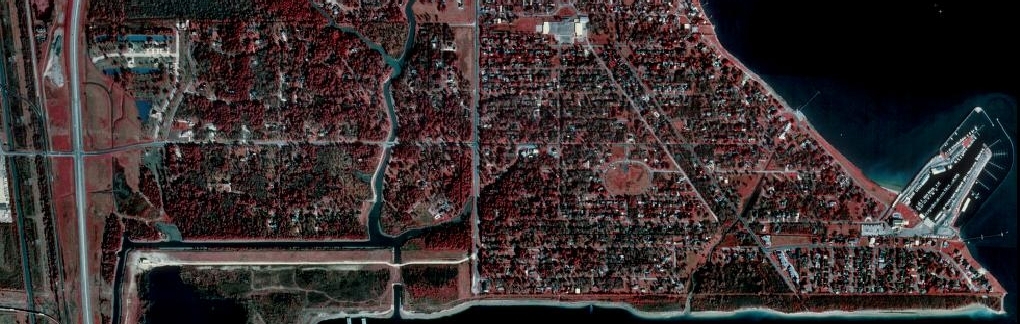
- ^ "2010 CENSUS - CENSUS BLOCK MAP: Shoreacres city, TX." U.S. Census Bureau. Retrieved on March 30, 2019. Aerial view.
- ^ "Attendance Zones." La Porte Independent School District. Retrieved on March 30, 2019.
- ^ Texas Education Code, Sec. 130.197. SAN JACINTO COLLEGE DISTRICT SERVICE AREA..
- ^ "Clinic/Emergency/Registration Center Directory By ZIP Code". Harris County Hospital District. November 19, 2001. Archived from the original on November 19, 2001. Retrieved April 8, 2021. - See ZIP code 77571. See this map for relevant ZIP code.
- ^ Juan A. Lozano & Chris Duncan, Associated Press Writers (September 13, 2008). "Ike blasts Texas coast, floods homes, cuts power". Yahoo! NEWS. Archived from the original on September 16, 2008. Retrieved September 13, 2008.
- ^ a b Snyder, Mike Tiny Shoreacres bares big burden Two months after it was hit hard by the storm, the small coastal village in the 'shadow of La Porte' is still in ruins, with 88% of homes and half of its people gone, Houston Chronicle, November 12, 2008, retrieved Nov. 13, 2008
- ^ "Clear Lake/La Porte/Seabrook 5." Harris County Transit. Retrieved on January 15, 2010.
External links[edit]
- City of Shoreacres official website
- Shoreacres, Texas from the Handbook of Texas Online
- U.S. Geological Survey Geographic Names Information System: Shoreacres, Texas
| Large cities |  | |
|---|---|---|
| Other cities | ||
| CDPs and non- municipalities | ||
| Counties | ||
| Subregions | ||
| Bodies of water | ||
| Major ports | ||
| Nature preserves | ||
| Counties |  | |
|---|---|---|
| "Principal" cities | ||
| Other cities |
For a complete listing, see list of cities and towns in Houston–The Woodlands–Sugar Land MSA | |
| Unincorporated areas | ||
| Bodies of water | ||
Municipalities and communities of Chambers County, Texas, United States | ||
|---|---|---|
| Cities |  | |
| CDPs | ||
| Other communities | ||
| Footnotes | ‡This populated place also has portions in an adjacent county or counties
±water surface only; land in adjacent county | |
