
Somerset Dam, Queensland
| Somerset Dam Queensland | |||||||||||||||
|---|---|---|---|---|---|---|---|---|---|---|---|---|---|---|---|
 Stanley River Township from Quarry Hill, 1937 | |||||||||||||||
 Somerset Dam | |||||||||||||||
| Coordinates | 27°07′02″S 152°33′05″E / 27.1172°S 152.5513°E | ||||||||||||||
| Population | 69 (2016 census)[1] | ||||||||||||||
| • Density | 3.165/km2 (8.20/sq mi) | ||||||||||||||
| Postcode(s) | 4312 | ||||||||||||||
| Area | 21.8 km2 (8.4 sq mi) | ||||||||||||||
| Time zone | AEST (UTC+10:00) | ||||||||||||||
| Location | |||||||||||||||
| LGA(s) | Somerset Region | ||||||||||||||
| State electorate(s) | Nanango | ||||||||||||||
| Federal division(s) | Blair | ||||||||||||||
| |||||||||||||||
Somerset Dam is a rural town and locality in the Somerset Region, Queensland, Australia.[2][3] In the 2016 census, Somerset Dam had a population of 69 people.[1] When first being planned, it was unofficially known as the Stanley River township.
Geography[edit]
The town lies on the slopes of Mount Brisbane (27°05′19″S 152°31′38″E / 27.0886°S 152.5272°E) on the western bank of the Stanley River immediately below and south-west of the wall of the Somerset Dam (27°06′55″S 152°33′23″E / 27.1154°S 152.5565°E) which impounds the river creating Lake Somerset (27°02′00″S 152°34′00″E / 27.0333°S 152.5667°E).[4][5][6]
The Deer Reserve National Park (27°04′52″S 152°31′34″E / 27.0811°S 152.526°E) is in the north-west of the locality. The national park is 3,228 hectares (7,980 acres) and extends into the neighbouring localities of Hazeldean to the north, Cooeeimbardi to the north-west and Fulham further to the north-west.[7][8]
History[edit]
The town was constructed in 1935 to provide accommodation for those working on the construction of the dam and their families with the first businesses opening in 1936. The town was designed by civil engineer Charles Bank Mott like a suburban with gravel streets, electricity, street lights, reticulated water, stormwater drainage, and sewerage. Mott was seconded for three years from the Brisbane City Council.[9]
When the project commenced, the town was informally known as the Stanley River township. The Queensland Government decided to call the town Somerset after local pastoralist Henry Plantagenet Somerset, the Member of the Queensland Legislative Assembly for Stanley from 1904 to 1920. However, the postal authorities objected, fearing confusion with Somerset in Far North Queensland and Somerset in Tasmania. In January 1936 it was officially named Somerset Dam after the dam, which was named after Henry Plantagenet Somerset.[2][10]
As there was already a Somerset State School near Kilcoy (which had opened in 1915), the education authorities had decided to call the town's school Silverton. Silverton Provisional School opened in February 1936 at the end of First Avenue (27°07′04″S 152°33′02″E / 27.1178°S 152.5505°E).[11][12] In 1958 it became Silverton State School. Circa 1959 it was renamed Somerset State School (the school of that name near Kilcoy having closed in 1943). On 24 January 1966 it renamed Somerset Dam State School. It closed on 31 December 2000.[13]
The dam was being built as part of a program of providing employment during the Great Depression. During World War II construction of the dam was halted to enable the workers to be redeployed on war-related work, such as the Cairncross Dockyard with work resuming in 1948. About 450 people were employed constructing the dam during which time the population of the town exceeded 1000 people.[9]

St Mark's Anglican Church at First Avenue (27°07′04″S 152°33′03″E / 27.1177°S 152.5508°E) was dedicated on 30 August 1936 by Archbishop William Wand.[14][15] The church building was the former St Mark's Anglican Church of Fernvale which, having closed in 1934, was purchased by the Queensland Government for £50, relocated to Somerset Dam, renovated and re-roofed.[16][17] The church closed circa 1995.[18] As at 2020, the church building still exists but has been converted to holiday accommodation.[19]
On the same day and at the same time as the Anglich church was dedicated, so too was St Joseph's Catholic Church at 5 King Street (27°07′07″S 152°33′04″E / 27.1187°S 152.5510°E). It was blessed and dedicated by Archbishop James Duhig.[14][20]
In the 2016 census, Somerset Dam had a population of 69 people.[1]
Amenities[edit]
St Joseph's Catholic Church is at 5 King Street (27°07′07″S 152°33′04″E / 27.1187°S 152.5510°E). It is part of the Parish of St Mel's at Esk.[21]
References[edit]
- ^ a b c Australian Bureau of Statistics (27 June 2017). "Somerset Dam (SSC)". 2016 Census QuickStats. Retrieved 20 October 2018.
- ^ a b "Somerset Dam – town in Somerset Region (entry 31389)". Queensland Place Names. Queensland Government. Retrieved 16 May 2020.
- ^ "Somerset Dam – locality in Somerset Region (entry 44917)". Queensland Place Names. Queensland Government. Retrieved 16 May 2020.
- ^ "Queensland Globe". State of Queensland. Retrieved 3 July 2020.
- ^ "Mount Brisbane – mountain in the Somerset Region (entry 4564)". Queensland Place Names. Queensland Government. Retrieved 3 July 2020.
- ^ "Lake Somerset – reservoir in the Somerset Region (entry 31392)". Queensland Place Names. Queensland Government. Retrieved 3 July 2020.
- ^ "Queensland Globe". State of Queensland. Retrieved 3 July 2020.
- ^ "Deer Reserve National Park – National park in the Somerset Region (entry 44059)". Queensland Place Names. Queensland Government. Retrieved 3 July 2020.
- ^ a b "Nomination Document for the Somerset Dam" (PDF). Engineers Australia. January 2010. Archived (PDF) from the original on 3 July 2020. Retrieved 3 July 2020.
- ^ ""SOMERSET DAM"". The Courier-mail. No. 739. Queensland, Australia. 11 January 1936. p. 12. Retrieved 3 July 2020 – via National Library of Australia.
- ^ "THE SILVERTON STATE SCHOOL". Queensland Times. Vol. LXXVI, no. 15, 369. Queensland, Australia. 17 February 1936. p. 8 (DAILY). Retrieved 3 July 2020 – via National Library of Australia.
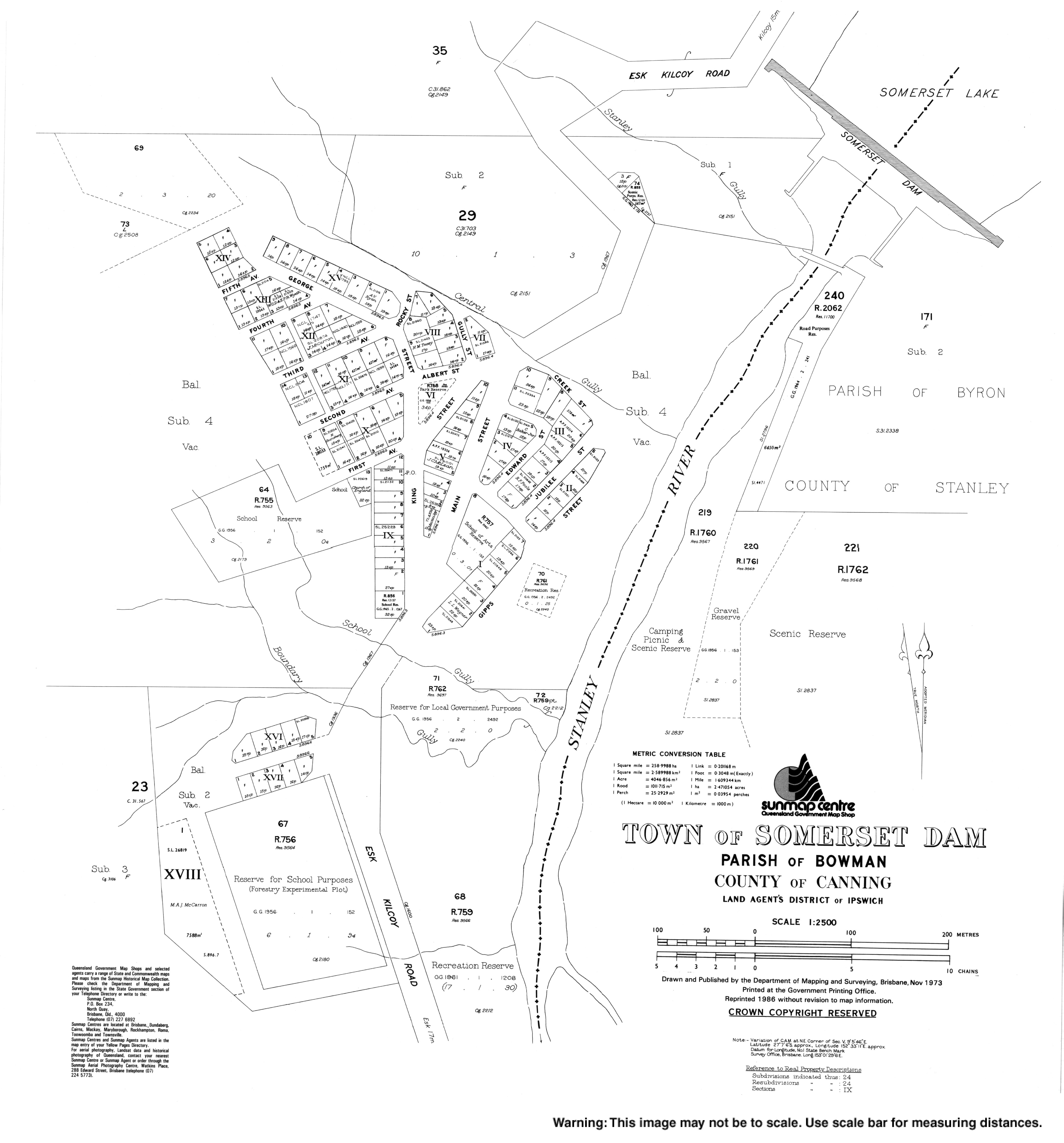
- ^ "Town of Somerset Dam" (Map). Queensland Government. 1973. Retrieved 28 April 2022.
- ^ Queensland Family History Society (2010), Queensland schools past and present (Version 1.01 ed.), Queensland Family History Society, ISBN 978-1-921171-26-0
- ^ a b "CHURCHES DEDICATED". Queensland Times. Vol. LXXVII, no. 15, 536. Queensland, Australia. 31 August 1936. p. 8 (DAILY.). Retrieved 31 May 2019 – via National Library of Australia.
- ^ "St. Mark's Church". Queensland Times. Vol. LXXVII, no. 15, 536. Queensland, Australia. 31 August 1936. p. 8 (DAILY.). Retrieved 3 July 2020 – via National Library of Australia.
- ^ "RELIGIOUS NOTES". The Courier-mail. No. 698. Queensland, Australia. 23 November 1935. p. 5. Retrieved 17 February 2021 – via National Library of Australia.
- ^ "TWO NEW CHURCHES AT STANLEY DAM". Queensland Times. Vol. LXXVII, no. 15, 535. Queensland, Australia. 29 August 1936. p. 8 (DAILY.). Retrieved 28 July 2020 – via National Library of Australia.
- ^ "Closed Anglican Churches". Anglican Church South Queensland. Archived from the original on 3 April 2019. Retrieved 29 June 2020.
- ^ "The Church Somerset Dam". Archived from the original on 3 July 2020. Retrieved 3 July 2020.
- ^ "St. Joseph's Church". Queensland Times. Vol. LXXVII, no. 15, 536. Queensland, Australia. 31 August 1936. p. 8 (DAILY.). Retrieved 3 July 2020 – via National Library of Australia.
- ^ "St Joseph's Church, Somerset Dam". Archdiocese of Brisbane. Archived from the original on 3 July 2020. Retrieved 3 July 2020.
Further reading[edit]
- Kilcoy State School : the first one hundred years, 1892-1992 : commemorative issue: including the closed small schools of Gregor's Creek, Sheep Station Creek, Stanley River, Villeneuve, West Vale, Wineya, Woolmar and Yednia, Kilcoy State School Centenary Committee, 1992
External links[edit]
- "Town map of Somerset Dam". Queensland Government. 1973. Archived from the original on 3 July 2020.
- Photograph Albums of Construction of Somerset Dam 1937, State Library of Queensland