Soperton, Georgia
Soperton, Georgia | |
|---|---|
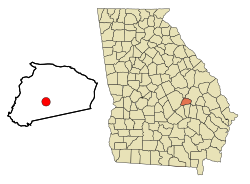
 Location in Treutlen County and the state of Georgia | |
| Coordinates: 32°22′34″N 82°35′34″W / 32.37611°N 82.59278°W | |
| Country | United States |
| State | Georgia |
| County | Treutlen |
| Government | |
| • Mayor | John Koon |
| • City Council | Wade Clark / Misty Brantley / Izell Stephens / Stephanie Blair / Xandra Brown |
| Area | |
| • Total | 4.46 sq mi (11.56 km2) |
| • Land | 4.40 sq mi (11.40 km2) |
| • Water | 0.06 sq mi (0.16 km2) |
| Elevation | 295 ft (90 m) |
| Population (2020) | |
| • Total | 2,889 |
| • Density | 656.29/sq mi (253.38/km2) |
| Time zone | UTC-5 (Eastern (EST)) |
| • Summer (DST) | UTC-4 (EDT) |
| ZIP code | 30457 |
| Area code | 912 |
| FIPS code | 13-71772[2] |
| GNIS feature ID | 0323223[3] |
| Website | City of Soperton |
Soperton is a city in Treutlen County, Georgia, United States. The population was 2,889 in 2020. The city is the county seat of Treutlen County.[4]
History[edit]
A post office was established at Soperton in 1902.[5] The city was named after Benjamin Franklin Soper, a railroad official.[6]
The Georgia General Assembly incorporated Soperton as a town in 1902.[7]
Geography[edit]
Soperton is located at 32°22′34″N 82°35′34″W / 32.37611°N 82.59278°W (32.376067, -82.592724).[8]
According to the United States Census Bureau, the city has a total area of 3.3 square miles (8.5 km2), of which 3.2 square miles (8.3 km2) is land and 0.04 square miles (0.10 km2) (0.61%) is water.
Demographics[edit]
| Census | Pop. | Note | %± |
|---|---|---|---|
| 1910 | 469 | — | |
| 1920 | 1,033 | 120.3% | |
| 1930 | 1,081 | 4.6% | |
| 1940 | 1,339 | 23.9% | |
| 1950 | 1,667 | 24.5% | |
| 1960 | 2,317 | 39.0% | |
| 1970 | 2,596 | 12.0% | |
| 1980 | 2,981 | 14.8% | |
| 1990 | 2,797 | −6.2% | |
| 2000 | 2,824 | 1.0% | |
| 2010 | 3,115 | 10.3% | |
| 2020 | 2,889 | −7.3% | |
| U.S. Decennial Census[9] | |||
| Race | Num. | Perc. |
|---|---|---|
| White (non-Hispanic) | 1,097 | 37.97% |
| Black or African American (non-Hispanic) | 1,643 | 56.87% |
| Native American | 6 | 0.21% |
| Asian | 6 | 0.21% |
| Other/Mixed | 66 | 2.28% |
| Hispanic or Latino | 71 | 2.46% |
As of the 2020 United States census, there were 2,889 people, 1,088 households, and 699 families residing in the city.
Education[edit]
Treutlen County School District[edit]
The Treutlen County School District holds pre-school to grade twelve, and consists of one elementary school and a middle/high school.[11] The district has 74 full-time teachers and over 1,234 students.[12]
- Treutlen Elementary School
- Treutlen Middle/High School
References[edit]
- ^ "2020 U.S. Gazetteer Files". United States Census Bureau. Retrieved December 18, 2021.
- ^ "U.S. Census website". United States Census Bureau. Retrieved January 31, 2008.
- ^ "US Board on Geographic Names". United States Geological Survey. October 25, 2007. Retrieved January 31, 2008.
- ^ "Find a County". National Association of Counties. Retrieved June 7, 2011.
- ^ "Post Offices". Jim Forte Postal History. Retrieved June 10, 2019.
- ^ Krakow, Kenneth K. (1975). Georgia Place-Names: Their History and Origins (PDF). Macon, GA: Winship Press. p. 209. ISBN 0-915430-00-2.
- ^ "Treutlen County". GeorgiaInfo. Retrieved June 10, 2019.
- ^ "US Gazetteer files: 2010, 2000, and 1990". United States Census Bureau. February 12, 2011. Retrieved April 23, 2011.
- ^ "Census of Population and Housing". Census.gov. Retrieved June 4, 2015.
- ^ "Explore Census Data". data.census.gov. Retrieved December 18, 2021.
- ^ Georgia Board of Education, Retrieved June 29, 2010.
- ^ School Stats, Retrieved June 29, 2010.

