
Summer Shade, Kentucky
Summer Shade, Kentucky | |
|---|---|
 Summer Shade  Summer Shade | |
| Coordinates: 36°53′3″N 85°42′9″W / 36.88417°N 85.70250°W | |
| Country | United States |
| State | Kentucky |
| County | Metcalfe |
| Area | |
| • Total | 2.04 sq mi (5.28 km2) |
| • Land | 2.03 sq mi (5.27 km2) |
| • Water | 0.01 sq mi (0.01 km2) |
| Elevation | 896 ft (273 m) |
| Population | |
| • Total | 294 |
| • Density | 144.54/sq mi (55.82/km2) |
| Time zone | UTC-6 (Central (CST)) |
| • Summer (DST) | UTC-5 (CST) |
| ZIP code | 42166 |
| FIPS code | 21-74586 |
| GNIS feature ID | 504782[3] |
Summer Shade is an unincorporated community and census-designated place (CDP) in Metcalfe County, Kentucky, United States. As of the 2020 census, the population was 294.[2]
History[edit]
Originally the area was known as "Sartain Precinct" and later as "Glover's Creek"; W.M. Riggs, the postmaster, changed the name to Summer Shade in 1872.
Geography[edit]
Summer Shade is located in southwestern Metcalfe County. Kentucky Route 90 (KY 90), connecting Glasgow to Burkesville and the Dale Hollow Lake area, runs through Summer Shade. Glasgow is 14 miles (23 km) to the northwest, while Burkesville is 23 miles (37 km) to the southeast. KY 640 leads north from Summer Shade 11 miles (18 km) to Wisdom and 17 miles (27 km) to Knob Lick. KY 163 passes just east of the community, leading north 8 miles (13 km) to Edmonton, the Metcalfe county seat, and south 12 miles (19 km) to Tompkinsville.
According to the U.S. Census Bureau, the Summer Shade CDP has an area of 2.04 square miles (5.3 km2), of which 0.005 square miles (0.013 km2), or 0.25%, are water.[1] The community sits on a ridge that drains to the west and north to Glover Creek and south to Nobob Creek. Both creeks flow west toward Skaggs Creek, a tributary of the Barren River and part of the Green River watershed.
The rural-dominated area is home to the Kingsford Charcoal factory. Located 2 miles (3 km) east of Summer Shade on KY 90 near Beaumont, it identifies itself as a Summer Shade-based business.
Climate[edit]
The climate in this area is characterized by hot, humid summers and generally mild to cool winters. According to the Köppen Climate Classification system, Summer Shade has a humid subtropical climate, abbreviated "Cfa" on climate maps.[4]
Demographics[edit]
| Census | Pop. | Note | %± |
|---|---|---|---|
| 2020 | 294 | — | |
| U.S. Decennial Census[5] | |||
Education[edit]
There was one school in Summer Shade that was known as Summer Shade Elementary School. It went from grades K-6. Currently, students go to Metcalfe County Elementary in Edmonton.
Notable people[edit]
- Charles "Pat" Dougherty (1879–1939), baseball pitcher in the pre-Negro leagues
References[edit]
- ^ a b "2022 U.S. Gazetteer Files: Kentucky". United States Census Bureau. Retrieved May 18, 2023.
- ^ a b "P1. Race – Summer Shade CDP, Kentucky: 2020 DEC Redistricting Data (PL 94-171)". U.S. Census Bureau. Retrieved May 18, 2023.
- ^ U.S. Geological Survey Geographic Names Information System: Summer Shade, Kentucky
- ^ Climate Summary for Summer Shade, Kentucky
- ^ "Census of Population and Housing". Census.gov. Retrieved June 4, 2016.
Municipalities and communities of Metcalfe County, Kentucky, United States | ||
|---|---|---|
| City | 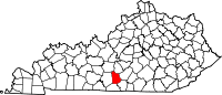 | |
| CDP | ||
| Other communities | ||
| Ghost town | ||