
Svir, Belarus
Svir
Сьвір (Belarusian) Svieriai | |
|---|---|
 | |
 Svir | |
| Coordinates: 54°49′N 26°24′E / 54.817°N 26.400°E | |
| Country | Belarus |
| Region | Minsk Region |
| District | Myadzyel District |
| Founded | 13th century |
| Elevation | 153 m (502 ft) |
| Population (2023)[1] | |
| • Total | 974 |
| Time zone | UTC+3 (MSK) |
| Postal code | 222387 |
Svir (Belarusian: Сьвір; Russian: Свирь; Lithuanian: Svieriai; Polish: Świr) is an urban-type settlement in Myadzyel District, Minsk Region, Belarus.[1][2][3][4] As of 2023, it has a population of 974.[1]
History[edit]
It is believed to have been founded in the 13th century by the Lithuanian duke Daumantas and was part of the Grand Duchy of Lithuania until the Third Partition of Poland in 1795.[2]
The mound in the town has remains of fortifications from the 14th to 16th centuries.[2]
In the 18th to 19th centuries, the Lithuanians in Svir and its vicinities were Slavicized.[2]
Gallery[edit]
-
 Market square in 1900
 -
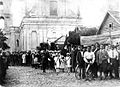 Town celebration in 1931
 -
 Town during World War I
 -
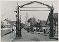 One of the Svir's streets in 1941
.jpg)
.jpg)
.jpg)
.jpg)
See also[edit]
References[edit]
Wikimedia Commons has media related to Svir.
- ^ a b c "Численность населения на 1 января 2023 г. и среднегодовая численность населения за 2022 год по Республике Беларусь в разрезе областей, районов, городов, поселков городского типа". belsat.gov.by. Archived from the original on 17 April 2023. Retrieved 5 October 2023.
- ^ a b c d Vidugiris, Aloyzas. "Svieriai". Visuotinė lietuvių enciklopedija (in Lithuanian). Retrieved 9 February 2023.
- ^ Słownik geograficzny Królestwa Polskiego i innych krajów słowiańskich, Tom XI (in Polish). Warsaw. 1890. p. 713. Retrieved 9 February 2023.
{{cite book}}: CS1 maint: location missing publisher (link) - ^ Назвы населеных пунктаў Рэспублікі Беларусь: Мінская вобласць: нарматыўны даведнік / І. А. Гапоненка, І. Л. Капылоў, В. П. Лемцюгова і інш.; пад рэд. В. П. Лемцюговай. — Мн.: Тэхналогія, 2003. — 604 с. ISBN 985-458-054-7. (djvu) С. 327.
| Districts (raiony) |  | |
|---|---|---|
| Cities and towns | ||
1 Administrative center of Minsk Region but administratively separated | ||