Talk:Three Countries Bridge
| This article is rated Start-class on Wikipedia's content assessment scale. It is of interest to the following WikiProjects: | |||||||||||
| |||||||||||
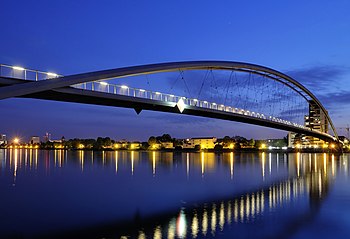
File:Weil am Rhein - Dreiländerbrücke10.jpg to appear as POTD[edit]
Hello! This is a note to let the editors of this article know that File:Weil am Rhein - Dreiländerbrücke10.jpg will be appearing as picture of the day on April 2, 2013. You can view and edit the POTD blurb at Template:POTD/2013-04-02. If this article needs any attention or maintenance, it would be preferable if that could be done before its appearance on the Main Page. Thanks! — Crisco 1492 (talk) 07:01, 17 March 2013 (UTC)
Units please![edit]
In the sidebar all dimensions are listed without units. That's a bad habit with no reason.
108.234.224.230 (talk) 04:24, 2 April 2013 (UTC)
Map[edit]
Badly needs a locator map. Sca (talk) 14:06, 2 April 2013 (UTC)
What does this mean?[edit]
This statement in the text doesn't seem to make sense: "On the up-river side it is a hexagonal cross-section of sheet steel, and downstream are two, the former is more inclined to the inside and the latter two are bearing the brunt. ". Can some one who knows about the subject correct it? 86.31.188.17 (talk) 22:00, 2 April 2013 (UTC)
What does this mean (2)?[edit]
"the line of sight of the Dreiländerbrücke between the main road and was offset a few metres." Does not make sense.
"805 metres (2,641 ft) of cables of 30 and 60 centimetres (12 and 24 in) in diameter." These cables are suspiciously large for an arch (as distinct from suspension etc.) bridge, could do with explanation if they're e.g. tensioning cables under the deck.
The article seems to have had a lot of (semi-)automatic editing after its original creation, this appears to have been done without the involvement of the original contributors/translators: were they involved with the design or promotion of the bridge in some capacity, and how has this got to POTD with such glaring errors in the text? MarkMLl (talk) 08:10, 3 April 2013 (UTC)
Line of sight[edit]

- I know what it means, but I don't know of a good way to phrase it concisely. Huningue was originally laid out by Vauban as a fortified border town. It has a square in the centre (Place Abbatucci). From the east of the square runs the Rue de France (appropriately named, as it was the entrance into France), which lined up with the former pontoon bridge (destroyed 1944, as per article) and with the Weil-am-Rhein Hauptstrasse (High Street) on the other side of the river. If you stand in the middle of Place Abbatucci, you can see straight across the river and to the hills beyond (Black Forest). See the photo on the right. It is not quite from the centre of the square, but if you expand it you can see the bridge in the distance. If the bridge were in line with the road it would block this view, so it is north of this by the width of the road. TiffaF (talk) 18:36, 13 June 2013 (UTC)
Cables[edit]


