
Talk:U.S. Route 33 in Michigan
| U.S. Route 33 in Michigan has been listed as one of the Engineering and technology good articles under the good article criteria. If you can improve it further, please do so. If it no longer meets these criteria, you can reassess it. | |||||||||||||
| U.S. Route 33 in Michigan is part of the U.S. Highways in Michigan series, a featured topic. This is identified as among the best series of articles produced by the Wikipedia community. If you can update or improve it, please do so. | |||||||||||||
| |||||||||||||
A fact from this article appeared on Wikipedia's Main Page in the "Did you know?" column on May 24, 2015. The text of the entry was: Did you know ... that for its first 25 years of existence in Michigan, US Highway 33 did not have an independent routing? | |||||||||||||
| Current status: Good article | |||||||||||||
| This article is rated GA-class on Wikipedia's content assessment scale. It is of interest to the following WikiProjects: | |||||||||||||||||||||||||||||||||||||||
| |||||||||||||||||||||||||||||||||||||||


Another section no longer on state highway system[edit]
On March 5, 2010, a segment of Bus. US 12 previously used by US 33 in downtown Niles was transferred back to city control. Otherwise, all of US 33 at its greatest extent from 1961 through 1987 remains part of a state highway in Michigan.
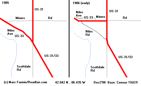
There is a section of former 33 too small to be seen on the scale of the MDOT maps, the sources for the above, that's no longer state highway: A piece of Niles Road at Scottdale, by M-63's southern terminus, which was removed from the system during a 1985-'86 construction project. A RS showing it as 31/33 can be this topo map, if USGS can be considered a RS, or, if not, someone might be able to dig up ROW or physical reference maps (not the inset on the MDOT maps, though, the intersections have been distorted on it); if more specific dates are necessary, articles are available at Newspapers.com (a starting point can be an article from April 1, 1985; [Added October 29, 2018] the "Scottdale Triangle" article from April 4, 1999 may also be of use). To get the full context see this diagram (obviously just for reference, not intended to be used in the article).
I wouldn't bring this up at all except that this section is roughly as long as the Niles section quoted. I'm not sure how this would fit into the article but it probably should be in order to be consistent; otherwise we should probably drop the paragraph entirely or at least make only passing mention ("except for reroutes..." or the like). Mapsax (talk) 15:25, 22 October 2018 (UTC)
- Wikipedia good articles
- Engineering and technology good articles
- GA-Class Featured topics articles
- Wikipedia featured topics U.S. Highways in Michigan good content
- High-importance Featured topics articles
- Wikipedia Did you know articles that are good articles
- GA-Class U.S. Highway system articles
- Mid-importance U.S. Highway system articles
- GA-Class Road transport articles
- Mid-importance Road transport articles
- U.S. Highway system articles
- GA-Class Michigan road transport articles
- Mid-importance Michigan road transport articles
- Michigan road transport articles
- GA-Class U.S. road transport articles
- Mid-importance U.S. road transport articles
- U.S. road transport articles