
Tankerton Slopes
| Site of Special Scientific Interest | |
 | |
 Location within Kent | |
| Location | Kent |
|---|---|
| Grid reference | TR 121 672[1] |
| Coordinates | 51°21′50″N 1°02′42″E / 51.364°N 1.045°E |
| Interest | Biological |
| Area | 2.3 hectares (5.7 acres)[1] |
| Notification | 1986[1] |
| Location map | Magic Map |
Tankerton Slopes is a 2.3-hectare (5.7-acre) biological Site of Special Scientific Interest in Whitstable in Kent.[1][2] It is part of the Tankerton Slopes and Swalecliffe Special Area of Conservation[3]
This north facing slope has a population of tall herbs, including the largest population in Britain of hog’s fennel, a nationally rare umbellifer. Fauna include agonopterix putridella, a nationally rare moth whose larvae feed exclusively on hog's fennel.[4]
There is access to the site from Tankerton Beach. The height of Tankerton slopes vary across the site, but are approximately 50 feet (15 metres) high when measured from the promenade or 66 feet (20 metres) in elevation from sea level.
The bottom of the slope is fronted by Beach huts,[5] and has a promenade that runs from Whitstable to Swalecliffe that is popular with dog walkers and cyclists.[6]
At the top of the slope to the West is a beacon that works by having a wood-based fire in a basket that is on top of a long wooden post.[7]
The site also offers a view in the distance of the "red sands" Maunsell Forts of the Thames Estuary,[8] the forty five wind turbines of Kentish Flats Offshore Wind Farm,[9][10] the Isle of Sheppey and at the West-end "The Street" a "Spit of land" that appears at low-tide and allows walking 750 meters[11] into the sea[12]
Gallery[edit]
-
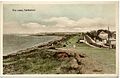 Tinted photograph on postcard dated around 1905-1914 showing "The Leas"
 -
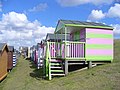 Colourful rows of wooden huts on the grassy slopes of "Tankerton slopes" below Marine Parade
 -
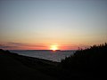 Sunset from Tankerton Slopes towards Sheppey - geograph.org.uk - 1564606
 -
 Tankerton Beacon
 -
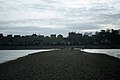 Tankerton Slopes as seen from "The Street"


.jpg)
References[edit]
- ^ a b c d "Designated Sites View: Tankerton Slopes". Sites of Special Scientific Interest. Natural England. Retrieved 1 March 2018.
- ^ "Map of Tankerton Slopes". Sites of Special Scientific Interest. Natural England. Retrieved 1 March 2018.
- ^ "Designated Sites View: Tankerton Slopes and Swalecliffe". Special Area of Conservation. Natural England. Retrieved 22 January 2018.
- ^ "Tankerton Slopes citation" (PDF). Sites of Special Scientific Interest. Natural England. Retrieved 1 March 2018.
- ^ "TBBHOA | Tankerton Bay Beach Hut Owners Association". Retrieved 13 December 2020.
- ^ "Tankerton Slopes". Explore Kent. Retrieved 13 December 2020.
- ^ "Remembrance beacons not lit over safety concerns". Kent Online. 9 November 2018. Retrieved 14 December 2020.
- ^ "Maunsell Army Sea Forts". Atlas Obscura. Retrieved 13 December 2020.
- ^ "Power plants: Kentish Flats - Vattenfall". powerplants.vattenfall.com. Retrieved 13 December 2020.
- ^ "Power plants: Kentish Flats Extension - Vattenfall". powerplants.vattenfall.com. Retrieved 29 August 2022.
- ^ "Cool Places - The Street - Tankerton Beach". www.coolplaces.co.uk. Retrieved 14 December 2020.
- ^ "The Street (Whitstable) - 2020 All You Need to Know BEFORE You Go (with Photos)". Tripadvisor. Retrieved 13 December 2020.