Tell Ain el Meten
| Location | Beqaa Valley, Lebanon |
|---|---|
| Part of | Factory |
| History | |
| Periods | Heavy Neolithic, Neolithic |
| Site notes | |
| Archaeologists | Peter Wescombe, J. King |
| Condition | ruins |
| Public access | Yes |

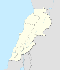
Tell Ain el Meten is a tell in the area of El Meten in the Rashaya District, south-eastern portion of the Bekaa Governorate of the Republic of Lebanon.[1][2] It is located opposite the village of Sawiri.
A Heavy Neolithic archaeological site of the Qaraoun culture was discovered by Peter Wescombe and J. King in 1966 along a track 200 metres (660 ft) north of the Ain el Meten spring and about 300 metres (980 ft) west of the road. The tell is cone shaped and composed of rubble stones and grey soil. Imported brown worked flint tools were found along with others made from Nummulitic, Eocene flint in the fields on the lower slopes. Another type of brittle and drab-coloured flint found in the area was unsuitable for toolmaking. The material was determined to be of Heavy Neolithic or possibly earlier Paleolithic origins.[3]
Pottery was also found suggested to date to the Early Bronze Age and Middle Bronze Age. This was evidenced by sherds with flat bases, grey or cream burnishing. The grey burnished sherds were equated to the Syrian bottle type. Various other sherds were found with finger impressed rims, to which could not be assigned a definite date. A handle from the Cypriot II stage was also found along with traces of occupation in the Late Iron Age and Islamic periods.[3]
The site was largely intact in 1966 with terracing for fruit trees in the area and a rocky crest of the tell, which had been ploughed.[3]
References
- ^ Ḥasan Abū al-ʻAynayn (1973). Essays on the geomorphology of the Lebanon. Beirut Arab University. Retrieved 5 September 2012.
- ^ Robert Boulanger (1966). The Middle East, Lebanon, Syria, Jordan, Iraq, Iran. Hachette. Retrieved 5 September 2012.
- ^ a b c L. Copeland; P. Wescombe (1966). Inventory of Stone-Age Sites in Lebanon: North, South and East-Central Lebanon, p. 26. Impr. Catholique. Retrieved 29 August 2011.

