
Tsapatagh
40°24′27″N 45°28′26″E / 40.40750°N 45.47389°E
Tsapatagh
Ծափաթաղ | |
|---|---|
 View of Lake Sevan from the village | |
 Tsapatagh  Tsapatagh | |
| Coordinates: 40°25′17″N 45°32′00″E / 40.42139°N 45.53333°E | |
| Country | Armenia |
| Province | Gegharkunik |
| Municipality | Shoghakat |
| Population | |
| • Total | 360 |
| Time zone | UTC+4 (AMT) |
| Area code | 1611[2] |
| Tsapatagh at GEOnet Names Server | |
Tsapatagh (Armenian: Ծափաթաղ) is a resort village in the Shoghakat Municipality of the Gegharkunik Province in Armenia, on the northeastern shore of Lake Sevan.[3]
Geography and nature[edit]


The village is located in the vicinity of the Tandzut river delta (not to be confused with identically named Tandzut river in the Lori province).[4] Other sources indicate different river names, the Tsapatagh river running through the village and the Shishkert river (or the Shampyrt river) to the southeast of the village.[5] In the surroundings of the village there is a 3,312 hectare large sanctuary with unique relict juniper and open oak woodlands with typical fauna and flora.[6][7] The climate is somewhat milder than on the western shores and fruit trees like apricot trees can be grown.
Economy and tourism[edit]
The Tufenkian Hotel with adjacent solar photovoltaic installations is located in the village. To the southeast, another much larger photovoltaic station is being constructed as of 2020.
Historical heritage sites[edit]
There is a 3,000-year old burial area three kilometres to the east of the village. In the southeast, about 1.5 kilometres away, there is a cemetery with khachkars dating from between the 14th and 18th centuries.[4]
Demographics[edit]
Population[edit]
In 2014 there were 379 residents according to the local administration.[8] In 2018 there was only one child who begun attending the local school.[9]
Many of modern local residents relocated to the village from Kushchu village of Dashkasan,[10] as well as from Baku and Ganja around 1988–1989.[4] Quite a few of the houses are used only in summer by Yerevan residents.
Gallery[edit]
-
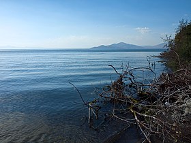 View from the shore of Lake Sevan in Tsapatagh
 -
 Panoramic view of Tsapatagh
 -
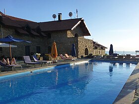 Hotel pool with a lake view
 -
 Hotel premises from the main road
 -
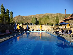 Hotel pool with a mountain view
.jpg)

.jpg)
.jpg)
.jpg)
References[edit]
- ^ Statistical Committee of Armenia. "The results of the 2011 Population Census of the Republic of Armenia" (PDF).
- ^ "Tzapatagh/Ծափաթաղ Postcode". armenia.postcode.info. Retrieved 2019-05-05.
- ^ Kiesling, Brady; Kojian, Raffi (2005). Rediscovering Armenia: Guide (2nd ed.). Yerevan: Matit Graphic Design Studio. p. 82. ISBN 99941-0-121-8.
- ^ a b c "Dictionary of settlements of Republic of Armenia" (PDF).
- ^ "ЭКОЛОГИЯ ОЗЕРА СЕВАН В ПЕРИОД ПОВЫШЕНИЯ ЕГО УРОВНЯ" (PDF).
- ^ "Story Map Journal". www.arcgis.com. Retrieved 2019-05-05.
- ^ "mnp". www.mnp.am (in Amharic). Retrieved 2019-05-05.
- ^ "Գեղարքունիքի մարզի Ծափաթաղ գյուղում բարելավվում են կենցաղային պայմանները". armenpress.am (in Armenian). Retrieved 2019-05-05.
- ^ "Yerevan.Today | Ծափաթաղ գյուղի միակ առաջին դասարանցին". yerevan.today (in Armenian). Retrieved 2019-05-05.
- ^ One, Studio. "Ծափաթաղ. փակ դռների ետևում միակ բնակիչը քամու սուլոցն է". www.yerkir.am (in Armenian). Retrieved 2019-05-05.
External links[edit]
- Report of the results of the 2001 Armenian Census, Statistical Committee of Armenia
- Kiesling, Brady (June 2000). Rediscovering Armenia: An Archaeological/Touristic Gazetteer and Map Set for the Historical Monuments of Armenia (PDF). Archived (PDF) from the original on 6 November 2021.

This article about a location in Gegharkunik Province, Armenia is a stub. You can help Wikipedia by expanding it. |