Ukkusissat
Ukkusissat | |
|---|---|
 Ukkusissat | |
| State | |
| Constituent country | |
| Municipality | |
| Government | |
| • Mayor | Jakob Amossen |
| Population (2010) | |
• Total | 170 |
| Time zone | UTC-03 |
| Postal code | 3961 Uummannaq |
Ukkusissat (old spelling: Uvkusigssat) is a settlement in the Qaasuitsup municipality, in northwestern Greenland. The population of the settlement was 170 in 2010.[2] The name means soapstone.[3]
Geography

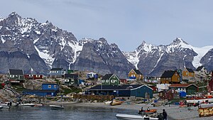
The settlement abuts the northwestern tip of the peninsula of the same name, jutting from the mainland to the west and northwest and into the inner waterways of the Uummannaq Fjord system.
To the north of the settlement, Perlerfiup Kangerlua, a large inner fjord empties into the main branch of Uummannaq Fjord.
To the south and southwest across Torsukattak Strait are the high mountains of the Salleq Island and the much larger Appat Island, alongside the flat Qeqertat skerries.[4]
Economy

Fishing is the main occupation in Ukkusissat, with the fish processing plant located at the harbour; many inhabitants employed at Royal Greenland. Reinvigoration of mining activities in the nearby Maamorilik site−located northeast of the settlement on the northern side of Perlerfiup Kangerlua−will provide an economic boost to the local economy.[5]
The community in Ukkusissat is served by Pilersuisoq, an all-purpose communal store. Tourism is underdeveloped, although during summer the settlement is visited by cruise ships, such as Norway's Hurtigruten.[6] The harbour in Ukkusissat cannot handle ships large ships due to shallow coastal waters.
Transport
Air

Air Greenland serves the village as part of government contract, with flights between Ukkusissat Heliport and Uummannaq Heliport.[7] Check-in for the helicopter flights is administered at Pilersuisoq.
Ground
In mid-winter, the only means of communication with Uummannaq and other settlements of the area is by dogsled, as district helicopters do not service the settlement at that time of year.[7]
Population
The population of Ukkusissat has dropped by more than 12 percent relative to the 1990 levels, and by more than a quarter relative to the 2000 levels, decreasing in nearly every year of the last decade, and reflecting a general trend in the region.[8]
Photographs
-
Houses and laundry in mid-summer
-
Pellerfiup Nunaa
-
Katersortarfiat, a "public house" used for parties, dancing, and other entertainment
-
Hunting guns in Pilersuisoq
-
Akuliarutsip Qaqaa. on the Ukkusissat Peninsula mountain range, view from Sermikassaq
References
- ^ knr.gl Template:Da icon
- ^ Statistics Greenland Template:Da icon
- ^ Jensen, Jens Fog; Erik Brinch Petersen (1998). "Raw material distribution ‐ social space, social interaction". Acta Borealia. 15 (2): 139–152. doi:10.1080/08003839808580482. ISSN 0800-3831.
Major historic quarries for soapstone are known from the Nuuk area to the south as well as from the Bay of Uummannaq to the north of Nuussuaq, at the village of Ukkusissat (ukkusissaq meaning 'soapstone').
{{cite journal}}: line feed character in|quote=at position 96 (help) - ^ Nuussuaq, Saga Map, Tage Schjøtt, 1992
- ^ Sermitsiaq
- ^ Hurtigruten.co.uk
- ^ a b "Booking system". Air Greenland. Retrieved 7 July 2010.
- ^ a b Statistics Greenland
External links
- sermitsiaq.gl Ukkusissat: Greenland masters in hospitality by Malik Milfeldt Template:Da icon


