
User:Brianboulton/Sandbox10
Links:
- User:Brianboulton/Sandbox
- User:Brianboulton/Sandbox2
- User:Brianboulton/Sandbox3
- User:Brianboulton/Sandbox4
- User:Brianboulton/Sandbox5
- User:Brianboulton/Sandbox6
- User:Brianboulton/Sandbox7
- User:Brianboulton/Sandbox8
- User:Brianboulton/Sandbox9
- User:Brianboulton/Sandbox11
- User:Brianboulton/Sandbox12
- User:Brianboulton/Sandbox13
- User:Brianboulton/Sandbox14
- User:Brianboulton/Sandbox15
- User:Brianboulton/Sandbox16
- User:Brianboulton/Sandbox17
- User:Brianboulton/Sandbox18
- User:Brianboulton/Sandbox19
- User:Brianboulton/Sandbox20
- User:Brianboulton/Sandbox 21
- User:Brianboulton/Sandbox 22
AAE drafts[edit]
Lead[edit]

The Australasian Antarctic Expedition, 1911–1914 was the brainchild of Douglas Mawson who was inspired by his role in Ernest Shackleton's Nimrod Expedition in 1907–09, to lead an expedition of his own. His target area was the largely unexplored coast due south of the Australian continental landmass, between Cape Adare in the east and Gaussberg in the west. The expedition was organised into three bases: one on the sub-Antarctic Macquarie Island and two on the Antarctic mainland. The main base, under Mawson's command, was set up at Cape Denison, about 300 miles west of Cape Adare, and a Far Western base under Frank Wild was established on the Shackleton Ice Shelf, more than 1,500 miles west of Cape Denison.
Activities at both bases, particularly Cape Denison, were hampered by extreme winds which often made outside work impossible. Nevertheless, in the course of the expedition, sledging parties covered around 2,600 miles of previously unexplored territory while its ship, SY Aurora, sailed alongside 1,800 miles of unmapped coastline. Scientific investigations included meteorological measurements, magnetic observations, a full oceanographic programme, together with the collection of many biological and geological samples, including discovery of the first meteorite found in Antarctica. The expedition was the first to establish and maintain wireless contact between Antarctica and Australia, using a relay station set up on Macquarie Island. Another intended innovation was the use of an aircraft, but this was thwarted by an accident before the expedition sailed. The fuselage of the damaged plane was adapted to form a motorised sledge or "air-tractor", but it proved to be of very limited utility.
The expedition was marred by the deaths of two of its members: Begrave Ninnis, who fell into a crevasse, and Xavier Mertz, whose death was probably due to food poisonong. Following these losses, Mawson, their sledging partner, had to make a harrowing solo journey back to base; he missed the ship, and as a result had to spend an extra year at Cape Denison, along with a relief party of six. This sojourn was made difficult by the mental breakdown of Sidney Jeffryes, the wireless operator. On his return to civilisation, Mawson was given a hero's welcome and received many honours, including a knighthood from King George V.
Background[edit]

In January 1909 a three-man party from Ernest Shackleton's British Antarctic (Nimrod) Expedition reached the location of the South Magnetic Pole.[1] The party included a young Australian geologist, Douglas Mawson, who, inspired by his experiences, came home with thoughts of organising his own expedition. His particular interest lay not in the South Pole, but in investigating the lands west of Cape Adare, immediately to the south of Australia, a coast that had been indeterminately explored in the 1840s by the French under Dumont D'Urville and by the American Charles Wilkes, but not visited since.[2]
In January 1910, in London, Mawson met Robert Scott, then preparing his Terra Nova Expedition. Mawson proposed to Scott that he should join the expedition as head an independent team, based at Cape Adare, which would [3] Then, while Shackleton raised funds lecturing in America, Mawson investigated a potentially lucrative investment scheme in a Hungarian goldmine. When this proved inconclusive, Mawson crossed the Atlantic to brief Shackleton, and to find out if his commitment to the expedition still stood. On 16 May, Shackleton issued a statement confirming Mawson's position as chief scientist, adding that, should he (Shackleton) be unable to accompany the expedition, "D. Mawson will be in charge and I shall still use my influence ... in regard to raising the necessary funds". With this assurance, Mawson returned to Australia.[4][5]
Months of silence from Shackleton followed, renewing Mawson's uncertainties. Finally, on 1 December, he received confirmation from Shackleton that he would not be going but would, as promised give Mawson his full support.[4][6]
Preparations[edit]
Aims[edit]
In January 1911 Mawson revealed his plans at a meeting of the Australasian Association for the Advancement of Science (AAAS).[7] He intended to operate in the Antarctic coastal arc between Cape Adare in the east, and Mount Gauss in the west. Within these bounds, Mawson said, lay territory "of whose outline and glacial features [only] the barest evidence has been furnished".[8] A full scientific and geographical investigation of these lands would be accompanied by a ship-based oceanographic programme.[9][10] The AAAS responded enthusiastically.[4] A committee was formed, under the chairmanship of Professor Edgeworth David of the University of Sydney (who had stood with Mawson at the South Magnetic Pole),[11] and Mawson soon acquired the backing of the scientific and political communities, as well as pledges of financial support from leading industrialists. Assured that his expedition was now safely launched, Mawson travelled to London to begin practical arrangements.[11]
Mawson's original intention had been to set up his main shore base at Cape Adare, with others established further west. He felt it necessary to modify this arrangement when, in March 1911, he learned that Scott's expedition was sending a Northern party to the Cape Adare region. As a consequence, decided to place his main base well to the west of the cape, in presently unknown territory.[12][n 1]
Ship and equipment[edit]

In London, in search of a suitable ship, Mawson sought the help of John King Davis, to whom he offered the post of ship's master and second-in-command of the expedition.[14] Davis had served as Nimrod's chief officer during Shackleton's recent expedition, and had acted as its captain on the voyage back to England. He accepted Mawson's offer without hesitation.[15][16]
Mawson hoped to secure one of the recent Antarctic expedition ships – Scott's Discovery, Nimrod, William Speirs Bruce's Scotia – but none were available. He finally settled on Aurora, an old Dundee whaler, built 1876.[17] In 1884, she had participated in the search for the missing American Arctic explorer Augustus Greely.[18] The cost was £6,000, which Mawson considered a bargain. [17][19] Davis supervised an extensive refit, which included alterations to her rigging and much internal reorganisation to provide appropriate accommodation, laboratories and extra storage space.[20]
The specialist equipment required for the oceanographic programme included two sounding machines: a No. 1 Lucas sounder for work in depths up to 6,000 fathoms (11,000 feet), lent to the expedition by Bruce, and a lighter Kelvin machine for use in shallower depths.[20] Mawson also acquired from Vickers a small aeroplane, for both its potential utility and its considerable publicity value.[21] The plane was shipped separately to Australia, where it was badly damaged during a demonstration flight, whereupon Mawson abandoned the idea of an aircraft, removing the wings and adapting the fuselage body and engine to create a motorised sledge, known as the "air-tractor".[22][23]
Mawson's technological interests extended to the then new area of wireless telegraphy. After discussions with the Commonwealth Meteorological Bureau, he decided to set up an extra base on Macquarie Island, at the midpoint between Tasmania and Antarctica, to act as relay station for wireless messages between Antarctica and Australia. The base would also enable the first proper survey and scientific study of the island.[24] [25]
Personnel[edit]
Before returning to Australia, Mawson recruited the Antarctic veteran Frank Wild – "the oldest resident of Antarctica" according to Mawson[26] – as leader of one of the proposed bases.[27] Wild had turned down an invitation to join Scott's expedition; he disliked Scott's rigidity, "too much the navy man".[28] Mawson also took on Belgrave Ninnis, a 23-year-old lieutenant in the Royal Fusiliers, son of a naval surgeon who had accompanied the British Arctic Expedition of 1875–76.[15][29] Ninnis was given charge of the expedition's dogs, even though he had no experience with them.[30] He would be assisted by Xavier Mertz, a Swiss ski-jumping champion, whose skiing expertise Mawson thought would be an important asset.[27] [31]
To preserve the expedition's distinctive Australasian character, Mawson recruited his science staff from the universities of Australia and New Zealand.[26] In key positions were a 22-year-old New Zealander, Eric Webb, who became chief magnetician,[32] and Cecil Madigan, also 22, who was appointed as the Main Base's meteorologist. Madigan deferred a Rhodes Scholarship at Oxford University for a year, in order to join the expedition.[32]. The decision to establish a wireless relay and scientific station on Macquarie Island meant the recruitment of a further five-man team. To command the station, Mawson appointed George Ainsworth from the Commonwealth Meteorological Bureau, along with two wireless technicians, a geologist and a biologist.[24]
Finance[edit]
In accordance with his undertaking to support the expedtion, Shackleton persuaded the press baron Lord Northcliffe, to publish an appeal for funds in the Daily Mail. This resulted in an immediate influx of money; more than £6,000 in two days.[33]. The British government gave £2,000,[34] and, after a successful presentation by Mawson, the Royal Geographical Society contributed £500.[35][36] All told, following the appeal, British sources provided an amount close to £10,000. [37][n 2]
In Australia, the Australian Commonwealth (federal) government gave £5,000, and the various state governments collectively provided £18,500.[39] Together with private donations and the London money, the expedition's total funds rose to around £38,000, still some way short of its spending commitments, but enough to send it on its way.[35][n 3] Fundraising efforts continued while the expedition was in the field;[41] finally, when it was over and the ship and other assets had been sold off, the overall deficit, according to Mawson's accounting, was £4,462. This, he hoped, would be made up by royalties on the sales of the expedition book and from lecture fees. He estimated that a further £8,000 would be required to meet the costs of publishing the scientific results.[42] The problems of meeting these financial obligations would preoccupy Mawson for many years.[43][n 4]
Expedition[edit]
Voyage south[edit]
On 28 July 1911, overladen with sledges, dogs and more than 3,000 cases of stores, Aurora left London for Cardiff, where she shipped 500 tons of coal briquettes.[46] She arrived at Queens Wharf, Hobart on 4 November, after a three-month voyage.[47] In a flurry of activity, additional fuel, stores and equipment were taken aboard and stowed away.[48][49] To relieve the strain, Mawson chartered a steamer, SS Toroa, to carry part of the burden as far as Macquarie Island.[50][51] After a series of farewell ceremonies and functions, Aurora left Hobart for Antarctica on 2 December, given a tumultuous dockside send-off.[52]
During the passage to Macquarie Island, part of Aurora's bridge was washed away, and the deck cargo suffered damage.[53][54] Waves repeatedly overwhelmed the ship, half-drowning the dogs and soaking the men.[55] The weather finally abated, and they reached Macquarie Island on 13 December, soon afterwards joined by Toroa.[56] After Ainsworth's party and its equipment were established on land, Toroa returned to Hobart, and on 24 December Aurora sailed on south.[57][58]
.jpg)
Mawson's hopes of finding a coastline west of Cape Adare similar to that around the cape were soon dashed.[59] The coast remained hidden behind impenetrable ice, and land reported by Wilkes appeared to be non-existent.[60] As the ship sailed further west, Mawson decided to reduce his land bases from three to two, by consolidating the proposed Central Base with the Main Base, with Wild in charge of a single Far Western base.[61] On 8 January, they found a wide indentation in the ice front, which Mawson later named Commonwealth Bay.[62] Here, a reconnaisance party found a rocky spot at a location which they named Cape Denison, after Sir Hugh Denison, one of the expedition's early sponsors, and decided to place the Main Base there.[63]
The work of unloading the ship, frequently interrupted by storms and winds, continued until 18 January.[64][65] The next day, with time running short before the onset of winter, Aurora sailed away to find a suitable site for Wild's Far Western base.[66]
Cape Denison[edit]
First season: winter 1912[edit]

The Main Base quarters provided a commodious living space, 24 x 24 feet, with an attached workshop and a wide verandah for storage and housing the dogs.[67] Away from the main huts were smaller structures, used for magnetic observations.[68] The party quickly discovered that their chosen location was an exceptionally windy spot; Carsten Borchgrevink, wintering at Cape Adare in 1899–1900, had reported occasional wind speeds of more than 60 km/hour, while at Cape Denison, in one 12-hour period, an average of 143 km/hour was maintained, with gusts exceeding 240 km/hour.[69] Unknowingly, they had settled in the one of the windiest sites in Antarctica.[70]
Mawson had planned, before winter closed in, to carry out some experimental sledging work, and on 1 March he, Madigan and Bob Bage managed a journey of five miles, before depositing a sledge and stores and returning to the hut.[71][72] After this journey, for the next five months life was largely concentrated in the hut, in pursuit of various scientific activities. Some outside work was inevitable; the meteorologists and the magneticians made their daily readings, regardless of conditions. As winter progressed, the hut became buried in snow drifts, and was difficult to locate; Alfred Hodgeman was lost for over three hours, returning from the anemometer a mere 150 yards away.[73] In rare lulls, efforts were made to erect the wireless masts and establish contact with Macquarie Island, but after repeated failures these attempts were abandoned at the end of April.[74]

The general routine of hut life was enlivened by elaborate celebrations of birthdays, often concluding with improvised concerts. When there was a dearth of birthdays, other occasions were eulogised; Mawson records that even the anniversary of the First Lighting of London by Gas was observed "with extraordinary eclat".[75] Much use was made of the expedition's library, especially the books that brought, as Mawson put it "the sudden breath of a world of warmth and colour, richness and vivacity".[76]
On 9 August Ninnis and Mertz ventured out, to carry stores up to the five-mile depot established in March. They gave this spot the name "Aladdin's Cave".[77][78] The beginning of September saw a break in the weather, which enabled work on the wireless masts to be completed. They began transmitting to Macquarie Island, but received nothing back.[79] Several short sledging journeys were possible in September before the weather closed in again;[80] on 9 October a particularly violent wind brought the wireless masts crashing down.[74][81]
Sledging, 1912–13[edit]
General plan[edit]
On 27 October, Mawson announced his plans for the sledging season ahead. A Southern party led by Bage would head south, towards the Magnetic Pole, making magnetic observations along the way. An Eastern Coastal party, under Madigan, would explore and map the coastline to the east of Cape Denison, while a Western party under Bickerton would take the motorised sledge to explore the plateau to the west. The longest journey would be undertaken by the Far Eastern party, consisting of Mertz, Ninnis and Mawson, which would take the dogs and attempt to reach Oates Land, some 350 miles distant in the vicinity of Cape Adare. Other groups would form support parties for the main journeys.[82][83] All parties would be required to return to base by 15 January, when Aurora was expected to bring them away.[84]
Far Eastern party[edit]

Mawson's Far Eastern party left on 10 November, and made good distances when weather allowed. By 14 December they had travelled more than 300 miles towards Oates Land.[85] Shortly after noon, as Mawson paused to calculate latitude, he saw that Mertz had stopped and was looking behind him. There was no sign of Ninnis. Mawson and Mertz retraced their steps, and found a wide hole; tracks on the far side made it clear that Ninnis, with his sledge and dogs, had fallen into the depths.[86] Far below on a ledge, they could see the bodies of two dogs, and debris from the sledge, but no sign of Ninnis.[87][88]
Shocked at the sudden loss of their companion, Mawson and Mertz now had to consider their own prospects. Ninnis's sledge had been carrying most of their provisions and equipment, and all of the dog food, leaving them with about 11 or 12 days' rations. To reach base they would have to augment these meagre supplies by shooting and eating the surviving dogs.[89] Over the next days they travelled steadily, and by 25 December they calculated that they were 158 miles from Cape Denison.[90] On 29 December they killed the last of the dogs.[91] Both men had been feeling unwell, but early in the New Year there was a sudden and rapid deterioration in Mertz's health. After a weather delay, they resumed their journey on 4 January, but Mertz's condition quickly worsened, and on 8 January he died.[92][93][n 5] Mawson was around 100 miles from the base, a relatively short distance, he observed, for a healthy man, but a long way for the weak and famished.[97][n 6]
After burying Mertz's body and clearly marking the grave, Mawson prepared for the journey ahead. To lighten his burden he used a small pocket tool to cut his sledge in half.[99] On 11 January the weather cleared and he set out, although his extreme weakness, in particular the condition of his feet, meant he could not travel great distances.[100] On 17 January he fell into a crevasse and hung there by a rope from the sledge, which fortunately had not fallen. It took him more than four hours to extricate himself.[101] As he drew nearer to safety, he was frustratingly delayed by more bad weather until 28 January. However, on that day he discovered a cairn, left by a search party, with a message telling him he was 21 miles from Aladdin's Cave.[102]
Three days later, Mawson reached the cave, but more bad weather held him there until 8 February. As he descended the slope towards the base, he thought he saw smoke on the horizon, the sign of the departing ship. When he arrived at the base, he found that the ship had indeed sailed, earlier that day, leaving a group of five – Bickerton, Bage, McLean, Madigan and Hodgeman – and a new wireless technician, Sidney Jeffryes, as a rescue party for the missing men.[103] Mawson radioed the ship, asking Davis to return and pick up the party; Davis attempted to comply, and brought the ship back to Commonwealth Bay, but a severe gale prevented the ship from anchoring, or from launching a boat. Worried that with further delays, Aurora would not reach Wild's Far Western party before being blocked by winter ice, Davis gave up and headed west,[104] leaving the Cape Denison group to spend another year at the base.[105]
Other sledging parties[edit]
The East Coast party under Madigan left the base on 8 November, following the coast eastwards. They continued, mapping as they went and collecting geological and biological samples, to just beyond the 150°E mark, 270 miles from the base. Near that point they discovered a rocky headland, more than 1,000 feet in height, with a spectacular columnar structure resembling organ pipes.[106] Madigan described this as a "cathedral of nature";[107] it was later named Horn Bluff, after one of the expedition's sponsors.[108] On their return journey, they celebrated Christmas Day as they camped on a glacier tongue, unaware that in the upper reaches of the same glacier, Mawson and Mertz were likewise camped.[109] After completing a full coastal survey, Madigan's party returned to the base on 16 January 1913.[110]
Bage's Southern party left Cape Denison on 10 November 1912,[111] and marched south in the direction of the Magnetic Pole as Webb made daily magnetic observations. They soon found that magnetic disturbances played havoc with the compass readings, and they steered by the sun, "a more than efficient substitute", Bage noted.[112] On 21 December they were 301 miles from the base, but their magnetic readings indicated that they were still some distance from the Magnetic Pole.[113] To avoid the risk of missing the ship, they turned for home. The latter part of this journey was harrowing, as they missed their final food depot, and had to make a rapid 60-mile dash to reach the base by 11 January.[114][115]
The Western party delayed its departure until 3 December, hoping that better weather would aid the running of the motor-sledge.[116] Initially the machine, which had performed satisfactorily in trials, ran well, but ten miles out from the base, one of its cylinders began misfiring. The trouble worsened; suddenly, the engine stalled and the propeller was wrecked. The motor-sledge was abandoned, and the party continued its journey by man-hauling,[117] travelling west across the plateau, for a distance of 158 miles before returning for home. Their most important geoplogical find was a meteorite, the first ever found in Antarctica.[118][119]
Second season, 1913–14[edit]
.jpg)
For the group left at Cape Denison, winter came early, largely confining them to the hut for many months. The previous year's programme of magnetic and meteorological observations was resumed, as were the routines of daily life at the base.[120] Many of the group found they had time on their hands, which McLean, in the tradition of earlier expeditions, used to produce and edit a magazine, the "Adelie Blizzard".[121][122] One major improvement from the previous year was that, from 20 February, regular contact with Macquarie Island was established, putting the group in touch with the world outside.[123] This period of communication lasted until 8 June, when strong winds brought down the wireless masts.[124]
The wireless operator, Jeffryes, had initially proved to be a conscientious and respected member of the group.[125] From mid-June onwards, however, his behaviour deteriorated. He became moody and aggressive, challenging comrades to fights, developing a persecution mentality, and neglecting his personal hygiene. This was alarming for the rest of the group, who lacked understanding of mental illness. When the masts were re-erected early in August, Jeffryes began sending out wild messages, claiming that the rest were trying to murder him.[126] Mawson instructed Ainsworth to censor all messages from Jeffryes before, in a period of lucidity, Jeffryes asked to be relieved from his duties, and Bickerton took over the wireless operator's role.[127]
In improving weather, Mawson decided on one final sledging party – himself, Madigan and Hodgeman – primarily to recover equipment that had been dumped or cached during the previous year's journeys. In this they were largely unsuccessful; they returned to base on 12 December; Aurora arrived the next day.[128] They finally left Cape Denison on 26 December; as they sailed away, they could see the cross, previously erected on high ground by Bickerton and McLean, commemorating their lost comrades, Ninnis and Mertz.[129][130]
Far Western base[edit]

Mawson had hoped to place the Far Western base no more than 500-600 miles west of Cape Denison, to make inter-base wireless communication possible.[131][132] As Aurora sailed west, well beyond the 500-mile mark, Davis was unable to find any feasible landing spot. On 15 February they were 1,500 miles from Cape Denison, and in danger that the ship would be frozen in for the winter. On that day, at 66°21'S, 94°51'E, they found a large ice shelf, and with no further opportunities for delay, Wild investigated it as a possible site for the base.[133][134] In spite of the obvious danger of the ice breaking up, Wild decided to risk it; he signed a letter indemnifying Davis from responsibility, should disaster occur. The base was established by 21 February, when Aurora sailed for Hobart.[135] They named the ice shelf after Shackleton, whose birthday fell on 15 February.[136]
In the course of the next year, the Far Western party completed a full programme of work. This included two major sledging journeys east and west of the base, mapping a total of over 350 miles. They also completed several depot-laying journeys, and an exploration of the inland plateau. They made regular meteorological, geological, magnetic and other scientific observations.[137] Wild led the eastern sledging party to a distance of 147 miles, before being halted by impassable ice.[n 7] The western party, led by Sydney Jones, travelled 234 miles to reach Gaussberg, the extinct volcano discovered by Drygalski's expedition in 1902.[140]
In February 1913 the party waited anxiously for Aurora's return. Lacking provisions for another year at the base, they prepared for the ship's non-arrival by building up stocks of seal and penguin meat.[141] To their great relief, Aurora appeared on 23 February; by that same evening the men, their equipment and their personal possessions were aboard, and the ship was on its way to Hobart.[142]
Macquarie Island[edit]

Ainsworth's party began daily meteorological observations from 1 January 1912, and the wireless station was erected on a high promontory christened "Wireless Hill".[143] By mid-February, the station had made contact with Australia,[144] and by 12 May was transmitting daily weather reports to Wellington, New Zealand.[145] Signals from Cape Denison were heard for the first time on 25 September, but the base was unable to receive messages back from Macquarie.[146][147]
On 20 February 1913, two-way communication with Cape Denison was finally established, and thereafter messages were regularly exchanged.[148] The Macquarie party, hoping for imminent relief, heard in March that Cape Denison would be operational for a second season, and that the Macquarie station would therefore need to remain open until November. A supply ship would transfer any of the party who wished to leave, but all elected to stay. By this time, provisions and fuel supplies were running low; severe winter weather prevented supply vessels from reaching them, and stores were reaching exhaustion point.[149] Not until 20 August was a supply ship able to land; Sawyer, who had fallen ill, was taken off the island.[150] Aurora arrived on 29 November, when the rest of the Macquarie party was picked up, replaced by members of the Commonwealth Meteorological Service.[151]
Oceanographic work[edit]
The expedition's main oceanographic work was carried out during two cruises in 1912, and in a coastal journey in 1914, after the final relief of Cape Denison. The first cruise, May to July 1912, included investigation of the supposed location, southwest of Tasmania, of the Royal Company's Islands, searched for without success on numerous previous occasions.[152] Aurora found no trace of them, nor of any shelving of the seabed that might suggest a sunken island.[153] The main sphere of oceanographic research was the sea around Macquarie Island and further south towards the Auckland Islands.[154] The second cruise, in November 1912, returned to these waters. Three days out from Hobart, the measured seabed depth suddenly fell, from 1,940 fathoms the previous day to 792 fathoms. A repeat sounding, in case of error, produced 794 fathoms. Davis took this as evidence of a submerged ridge that might, in prehistoric times, have been part of a land bridge connecting Australia with the Antarctic. Subsequent soundings failed to substantiate this theory.[155]
After the residual Cape Denison party had been picked up in December 1913, Mawson decided that, before returning home, they would conduct a coastal and seabed survey to the west, as far as the Shackleton Ice Shelf.[156] This task proved arduous, and led to dissention between Mawson and Davis, the latter of whom was by this time sleep-deprived and exhausted. Mawson noted as much in his diary: "I hope the strain won't tell any more of him".[157]. The work began on 1 January 1914 and was largely complete by 2 February. After a harrowing period in the ice, during which Davis rarely left the bridge, Aurora began the journey home.[158]
Aftermath[edit]
On 26 February 1914, Aurora reached Adelaide to a warm and enthusiastic welcome.[159] For the next month, Mawson was engaged in a busy round of receptions and scientific meetings, before sailing for London on 1 April, accompanied by his new bride, Paquita Delprat, whom he had married the previous day. In London, he lectured to the Royal Geographical Society, visited the parents of Ninnis, and was received at Marlborough House by Alexandra, the Queen Mother, and her sister, the Dowager Empress of Russia.[160] On 29 June, before his return to Australia, he was knighted at Buckingham Palace by King George V. He was the recipient of many further honours.[161]
In Australia, he faced the reality of the expedition's debts. He had proposed to the Australian government that they purchase Aurora and the other artefacts and equipment from the expedition for £15,000 which, he reckoned, would not only meet all outstanding debts, but would finance the production of the scientific reports. The government turned him down.[162] He sold Aurora to Shackleton for a mere £3,200, for use in the latter's proposed Imperial Trans-Antarctic Expedition,[162] and hoped to meet the balance of debt through the sales of his expedition account, The Home of the Blizzard, and through the profits from Hurley's film and photographs. The outbreak of war in 1914 delayed the publication of the book, while the distribution of the film was hampered by contractual problems and later by the loss of public interest as a result of the war.[163] The scientific reports were produced piecemeal, over the next 30 years, the last appearing in 1947.[164]
Many of the expedition's personnel enlisted in the armed forces; Bob Bage was killed at Gallipoli in 1915.[165] Several would return to the Antarctic: Mawson as the leader of the British Australian and New Zealand Antarctic Research Expedition (BANZARE) in 1929–31;[166] Davis, as captain of Aurora for the relief voyage for the Ross Sea party in Shackleton's expedition,[167] and as captain of Discovery during the first stage of BANZARE.[166] Wild joined Shackleton's expedition,[168] as did Hurley,[169] who also signed up for BANZARE.[170] Wild was also with Shackleton on the latter's final expedition, with Quest, in 1921–22, and took over as leader following Shackleton's sudden death in January 1922.[171]
Two days after the arrival in Adelaide, Jeffryes took a train to his home in Toowoomba, but never arrived there; a month later he was found destitute, wandering in the bush. He was placed in the care of a mental home in Ararat, but after assaulting a member of the staff, he was committed to a criminal asylum, where he died in 1942. His family were highly critical of Mawson's lack of sympathy; they wrote him numerous letters without response. In 2018, Jeffryes was finally honoured by the erection of a plaque in Ararat cemetery, near the site of his unmarked grave.[172]
Appraisal[edit]
The scientific work of the expedition covered the fields of geology, biology, meteorology, terrestrial magnetism and oceanography;[173] the vast amounts of data filled multiple reports published over a period of 30 years. These reports provided a full description of Antarctica's extreme weather and of its animal and plant life.[174] This was the first expedition to successfully establish wireless contact between the Antarctic continent and the Australian mainland, through the relay station on Macquarie Island;[173] it also gave the first charting and mapping of the island.[175] Its eight major sledging parties travelled for a total of 2,600 miles, while Aurora sailed along 1800 miles of uncharted coastline,[173] mapping the continental shelf through 55° of longitude.[175] Hurley's photographs and films provided a comprehensive pictorial record. The expedition was the first step towards Australia's later territorial claims on the Antarctic continent.[173]
Many Antarctic features bear the names of expedition members, including Cape Mawson, Mawson Coast, Mawson Peninsula,[176] Madigan Nunatak,[177] Mertz Glacier,[178] Ninnis Glacier.[179] The Australasian expedition was on a greater scale than any of its predecessors in the field. According to the historian Gordon Hayes, "Mawson's expedition, judged by the magnitude both of its scale and of its achievements, was the greatest and most consummate expedition that ever sailed to Antarctica".[180] Frank Hurley's brief summary stated: "Shackleton grafted science on to exploration – Mawson added exploring to science".[181]
Notes and references[edit]
Notes[edit]
- ^ Scott's late decision to send a party to Cape Adare came when he discovered that his main polar rival, Roald Amundsen, had established his base camp at the Bay of Whales, close to King Edward VII Land which Scott had originally planned to explore with a secondary party. It was thought inappropriate that rival teams should work in essentially the same area. Scott did not consider it necessary to inform Mawson of his change of plan.[13]
- ^ Early in 1910, Mawson and Shackleton had secured a promise of £10,000 from Gerald Lysaght, a wealthy donor who had helped finance the British Antarctic Expedition.[3][38] When Mawson sought this money, he was shocked to discover that Lysaght had donated it to Shackleton personally, and that Shackleton had applied it to other, undisclosed purposes. This deception, as Mawson saw it, permanently soured relations between the two men.[15]
- ^ Apart from financial contributions, the expedition received many donations in kind. In London, Northcliffe's appeal brought gifts of supplies, equipment, whisky and tobacco;[37] in Australia, Aurora received free harbour and docking facilities from the state governments of Victoria and New South Wales.[40]
- ^ Mawson published, in Home of the Blizzard, a very precise account of moneys received. In total, from all sources, £52,270 (equivalent to about £5.2 million in 2018) was raised, against total expenditure of £56,732 (£5.7m). The deficit of £4,462 equates to just under £500,000 in 2018 terms. [44][45]
- ^ A medical report published in 1969 concluded that the most likely cause of Mertz's swift decline and death was vitamin A poisoning, from eating the dogs' livers which are rich in the vitamin to a level that can be toxic to humans.[94][95] The poisoning process was likely hastened by Mertz's weak physical condition and near-starvation.[96]
- ^ After the expedition, rumours circulated that Mawson had assisted his survival by resorting to cannibalism. According to a report published in the New York Globe, Mawson had considered this but decided "it would always leave a bad taste in my mouth", and decided not to. Mawson described the report as an outrageous invention. All his associates declared the idea preposterous, given Mawson's strict conservative morals. No evidence has ever been produced that validates the rumour.[98]
- ^ Wild named the land he reached after King George V, but did so without royal consent.[138] The name George V Land was subsequently given, with permission, to lands explored by Mawson's Far Eastern party, from the Cape Denison base.[106] Wild also named the plateau south of his base Queen Mary Land.[139]
Citations[edit]
- ^ Riffenburgh 2005, pp. 231, 244.
- ^ Riffenburgh 2009, pp. 35–36; Turney 2012, p. 213; Bryan 2011, pp. 264–265
- ^ a b Riffenburgh 2009, p. 38.
- ^ a b c Turney 2012, p. 214.
- ^ Riffenburgh 2009, pp. 38–39.
- ^ Riffenburgh 2009, pp. 39–40.
- ^ Riffenburgh 2009, p. 40.
- ^ Mawson 2008, p. xi.
- ^ Riffenburgh 2009, pp. 40–41.
- ^ Davis 1919, pp. 3–4.
- ^ a b Riffenburgh 2009, p. 41.
- ^ Turney 2012, p. 219.
- ^ Riffenburgh 2009, p. 47.
- ^ Riffenburgh 2009, pp. 41–42.
- ^ a b c Riffenburgh 2009, p. 42.
- ^ Béchervaise 1981.
- ^ a b Riffenburgh 2009, p. 44.
- ^ Davis 1919, pp. 5–8.
- ^ Bryan 2011, pp. 266–267.
- ^ a b Bryan 2011, p. 267.
- ^ Riffenburgh 2009, p. 45.
- ^ Riffenburgh 2009, pp. 49–50.
- ^ Fitzsimons 2012, pp. 324–325.
- ^ a b Riffenburgh 2009, p. 50.
- ^ Turney 2012, p. 224.
- ^ a b Mawson 2008, p. 13.
- ^ a b Fitzsimons 2012, p. 283.
- ^ Mills 2007, p. 126.
- ^ Coleman 2007, p. 201.
- ^ Fitzsimons 2012, pp. 282–283.
- ^ Riffenburgh 2011, pp. 45–46.
- ^ a b Riffenburgh 2009, p. 51.
- ^ Fitzsimons 2012, pp. 297–299.
- ^ Fitzsimons 2012, p. 293.
- ^ a b Turney 2012, p. 221.
- ^ Riffenburgh, pp. 43–44.
- ^ a b Turney 2012, p. 216.
- ^ Huntford 1985, p. 335.
- ^ Riffenburgh 2009, pp. 48–49.
- ^ Mawson 2008, p. 545.
- ^ Turney 2012, p. 253.
- ^ Mawson 2008, pp. 544–545.
- ^ Turney 2012, pp. 256–257.
- ^ Mawson 2008, pp. 543–544.
- ^ MeasuringWorth.
- ^ Bryan 2011, p. 269.
- ^ Davis 1919, pp. 11–15.
- ^ Riffenburgh 2009, pp. 51–53, 55–56.
- ^ Fitzsimons 2012, pp. 347–348.
- ^ Riffenburgh 2009, p. 55.
- ^ Fitzsimons 2012, p. 339.
- ^ Fitzsimons 2012, pp. 354–356.
- ^ Mills 2007, p. 135.
- ^ Riffenburgh 2009, pp. 56–57.
- ^ Fitzsimons 2012, pp. 358–60.
- ^ Riffenburgh 2009, p. 57.
- ^ Davis 1919, pp. 20–22.
- ^ Mills 2007, pp. 136–137.
- ^ Mawson 2008, p. 49.
- ^ Turney 2012, p. 227.
- ^ Riffenburgh 2009, pp. 61–62.
- ^ Riffenburgh 2009, pp. 62–63.
- ^ Turney 2012, p. 228.
- ^ Riffenburgh 2009, p. 64.
- ^ Fitzsimons 2012, pp. 402–404.
- ^ Turney 2012, p. 229.
- ^ Riffenburgh 2009, pp. 65–66.
- ^ Riffenburgh 2009, p. 69.
- ^ Turney 2012, p. 236–237.
- ^ Bryan 2011, p. 270.
- ^ Fitzsimons 2012, pp. 451–452.
- ^ Riffenburgh 2009, pp. 72–73.
- ^ Riffenburgh 2009, pp. 68–69.
- ^ a b Mawson 2008, p. 120.
- ^ Mawson 2008, p. 116.
- ^ Mawson 2008, pp. 117–118.
- ^ Riffenburgh 2009, p. 90.
- ^ Mawson 2008, p. 158.
- ^ Fitzsimons 2009, p. 507.
- ^ Riffenburgh 2009, pp. 94–95.
- ^ Fitzsimons 2012, p. 512.
- ^ Mawson 2008, p. 176.
- ^ Riffenburgh 2009, pp. 98–100.
- ^ Bickel 2000, p. 81.
- ^ Riffenburgh 2009, pp. 110–113.
- ^ Riffenburgh 2009, p. 115.
- ^ Turney 2012, pp. 241–242.
- ^ Bickel 2000, p. 119.
- ^ Fitzsimons 2012, pp. 540–541.
- ^ Riffenburgh 2009, p. 126.
- ^ Turney 2012, p. 242.
- ^ Riffenburgh 2009, pp. 126–130.
- ^ Fitzsimons 2009, pp. 556–559.
- ^ Riffenburgh 2009, pp. 136–137.
- ^ Turney 2012, p. 243.
- ^ Jacka 1986.
- ^ Fitzsimons 2012, p. 558.
- ^ Riffenburgh 2009, pp. 131–133.
- ^ Riffenburgh 2009, pp. 130–134.
- ^ Fitzsimons 2012, pp. 564–566.
- ^ Turney 2012, p. 244.
- ^ Turney 2012, p. 245.
- ^ Riffenburgh 2009, pp. 144–146.
- ^ Riffenburgh 2009, pp. 151–153.
- ^ Turney 2012, pp. 146–147.
- ^ a b Riffenburgh 2009, p. 158.
- ^ Madigan 2008, p. 276.
- ^ USGS Antarctica ID 6994.
- ^ Fitzsimons 2012, p. 552.
- ^ Fitzsimons 2012, p. 570.
- ^ Bage 2008, p. 226.
- ^ Bage 2008, p. 236.
- ^ Riffenburgh 2009, p. 157.
- ^ Fitzsimons 2012, pp. 563–564.
- ^ Bage 2008, p. 253.
- ^ Mawson 2008, pp. 294–295.
- ^ Mawson 2008, pp. 295–296.
- ^ Turney 2012, p. 248.
- ^ Mawson 2008, p. 297.
- ^ Riffenburgh 2009, pp. 156–157.
- ^ Fitzsimons 2012, pp. 628–630.
- ^ Mawson 2008, pp. 401–403.
- ^ Mawson 2008, pp. 398–400.
- ^ Riffenburgh 2009, p. 160.
- ^ Riffenburgh 2009, p. 159.
- ^ Turney 2012, pp. 250–251; Riffenburgh 2009, pp. 161–167; Cansdale 19 October 2018
- ^ Riffenburgh 2009, p. 168.
- ^ Riffenburgh 2009, pp. 169–171.
- ^ Riffenburgh 2009, p. 173.
- ^ Fitzsimons 2012, p. 651.
- ^ Mills 2007, p. 139.
- ^ Fitzsimons 2009, p. 431.
- ^ Fitzsimons 2012, pp. 431–432.
- ^ Mills 2007, pp. 139–140.
- ^ Fitzsimons 2012, pp. 436–438.
- ^ Mills 2007, p. 140.
- ^ Mills 2007, p. 142.
- ^ Fitzsimons 2012, pp. 553, 706 (n.40).
- ^ Fitzsimons 2012, p. 500.
- ^ USGS Antarctica ID 5529.
- ^ Fitzsimons 2017, p. 617.
- ^ Mills, p. 191.
- ^ Ainsworth 2008, p. 426–428.
- ^ Ainsworth 2008, p. 439.
- ^ Ainsworth 2008, p. 453.
- ^ Ainsworth 2008, p. 469.
- ^ Riffenburgh 2009, pp. 92–93.
- ^ Riffenburgh 2009, pp. 158–159.
- ^ Ainsworth 2008, p. 485–491.
- ^ Ainsworth 2008, p. 492.
- ^ Davis 1919, p. 109.
- ^ Wharton 1904, p. 32.
- ^ Turney 2012, p. 235.
- ^ Davis 1919, pp. 63–67, 70–73.
- ^ Turney 2019, pp. 235–236.
- ^ Fitzsimons 2012, pp. 653–654.
- ^ Riffenburgh 2009, pp. 174–175.
- ^ Riffenburgh 2009, pp. 175–176.
- ^ Fitzsimons 2012, pp. 654–656.
- ^ Riffenburgh 2009, pp. 178–181.
- ^ Fitzsimons 2012, p. 664.
- ^ a b Fitzsimons 2012, p. 659.
- ^ Riffenburgh 2009, pp. 181–182.
- ^ Fitzsimons 2012, p. 673.
- ^ Riffenburgh 2009, p. 184.
- ^ a b Riffenburgh 2009, pp. 200–204.
- ^ Riffenburgh 2009, p. 185.
- ^ Mills 2007, p. 198.
- ^ Mills 2007, p. 195.
- ^ Turney 2012, p. 285.
- ^ Mills 2007, pp. 286–287, 295–297.
- ^ Cansdale 19 October 2018.
- ^ a b c d Killick 2012.
- ^ Turney 2012, p. 257.
- ^ a b American Geographical Society p. 44.
- ^ Alberts 1981, p. 540.
- ^ Alberts 1981, p. 522.
- ^ Alberts 1981, p. 558.
- ^ Alberts 1981, pp. 604–605.
- ^ Turney 2012, pp. 257–258.
- ^ Turney 2012, p. 258.
Sources[edit]
Books
- Alberts, Fred G. (ed) (1981). Geographic Names of the Antarctic. Washington DC: US National Science Foundation. OCLC 497666264.
{{cite book}}:|first=has generic name (help); Cite has empty unknown parameter:|1=(help) - Bickel, Lennard (2000). Mawson's Will: The Greatest Polar Survival Story Ever Written. Lebanon, NH: Steerforth Press. ISBN 978-1-5864-2000-0.
- Bryan, Rorke (2011). Ordeal by Ice: Ships of the Antarctic. Dobbs Ferry, NY: Sheridan House. ISBN 978-1-57409-312-4.
- Coleman, E. C. (2007). The Royal Navy in Polar Exploration: from Franklin to Scott. Stroud, Gloucestershire: Tempus Publishing. ISBN 978-0-7524-4207-5.
- Davis, John King (1919). With the Aurora in the Antarctic, 1911–1914. London: Andrew Melrose. OCLC 1058427147.
- Fitzsimons, Peter (2012). Mawson and the Ice Men of the Heroic Age. Sydney: William Henemann Australia. ISBN 978-1-74275-279-2.
- Huntford, Roland (1985). Shackleton. London: Hodder & Stoughton. ISBN 978-0-340-25007-5.
- Mawson, Douglas (2008) [1915]. The Home of the Blizzard. Oxford: Benediction Classics. ISBN 978-1-84902-172-2. (originally published in London, 1915, by William Heinemann)
- Ainsworth, George (2008) [1915]. "XXV: Life on Macquarie Island; XXVI: A Land of Storm and Mist; XXVII; Through Another Year". In Douglas Mawson (ed.). The Home of the Blizzard. Oxford. ISBN 978-1-84902-172-2.
{{cite book}}: CS1 maint: location missing publisher (link) - Bage, Bob (2008) [1915]. "XIV: The Quest of the South Magnetic Pole". In Douglas Mawson (ed.). The Home of the Blizzard. Oxford. ISBN 978-1-84902-172-2.
{{cite book}}: CS1 maint: location missing publisher (link) - Madigan, Cecil (2008) [1915]. "XV: Eastward over the Sea-ice; XVI: Horn Bluff and Penguin Point". In Douglas Mawson (ed.). The Home of the Blizzard. Oxford. ISBN 978-1-84902-172-2.
{{cite book}}: CS1 maint: location missing publisher (link)
- Ainsworth, George (2008) [1915]. "XXV: Life on Macquarie Island; XXVI: A Land of Storm and Mist; XXVII; Through Another Year". In Douglas Mawson (ed.). The Home of the Blizzard. Oxford. ISBN 978-1-84902-172-2.
- Mills, Leif (2007). Frank Wild. Whitby: Caedmon of Whitby. ISBN 978-0-905355-48-1.
- Riffenburgh, Beau (2005). Nimrod: Ernest Shackleton and the Extraordinary Story of the 1907–09 British Antarctic Expedition. London: Bloomsbury Publishing. ISBN 978-0-7475-7253-4.
- Riffenburgh, Beau (2009). Racing with Death: Douglas Mawson, Antarctic Explorer. London: Bloomsbury Publishing. ISBN 978-0-7475-9671-4.
- Turney, Chris (2012). 1912: The Year the World Discovered Antarctica. London: The Bodley Head. ISBN 978-1-84792-174-1.
Journals and Magazines
- "The Australasian Antarctic Expedition 1911–1914". Bulletin of the American Geographical Society. 47 (1). American Geographical Society: 37–44. 1915. doi:10.2307/201117. JSTOR 201117. Retrieved 26 November 2014.
- Killick, David (23 May 2012). "Life and Death in the Home of the Blizzard". Australian Antarctic Magazine (22). (Australian) Department of the Environment and Energy. Retrieved 26 November 2019.
- Wharton, W.J.L. (1 July 1904). "Expunged Islands". Emu – Austral Ornithology. IV (1): 32. doi:10.1071/MU90432a (inactive 2022-06-26).
{{cite journal}}: CS1 maint: DOI inactive as of June 2022 (link)
Websites
- Béchervaise, John (1981). "Davis, John King (1884–1967)". Australian Dictionary of Biography Volume 8. Australian National University. Retrieved 26 November 2019.
- Cansdale, Dominic (19 October 2018). "Remembering the explorer with schizophrenia of Mawson's Antarctic Expedition". ABC News. Retrieved 26 November 2019.
- Jacka, F.J. (1986). "Mawson, Sir Douglas (1882–1958)". Australian Dictionary of Biography Volume 10. Australian National University. Retrieved 26 November 2019.
- "Five Ways to Compute the Relative Value of a UK Pound Amount, 1270 to Present". MeasuringWorth. 2019. Retrieved 26 November 2019.
- "Antarctica detail: Gaussberg". USGS. U.S. Department of the Interior. Retrieved 26 November 2019.
- "Antarctica detail: Horn Bluff". USGS. U.S. Department of the Interior. Retrieved 26 November 2019.
Gallery[edit]
-
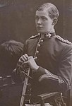 Belgrave Ninnis
 -
 Xavier Mertz
 -
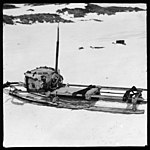 Mawson's half sledge
 -
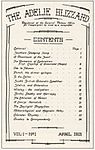 Cover first edition of Adelie Blizzard newspaper dated April 1913
 -
 Signatures of some expedition members
 -
 The air-tractor sledge in 1912


