
User talk:Ahoerstemeier/Archive 1
| This page is an archive of past discussions. Do not edit the contents of this page. If you wish to start a new discussion or revive an old one, please do so on the current talk page. |
Hello and Welcome! I hope you like the place. --mav
Hello, I've seen your new articles about Maerkischer Kreis and Hemer, Germany. I don't know if you plan to add more articles on German towns and districts; if so, that would be great, since your contributions are really good, and my progress in adding this stuff is quite slow. Just a little remark: We don't have to name articles Hemer, Germany, if just one Hemer exists on this planet (or is likely to be the only one mentioned in an article). So the title of the article should be just Hemer (and accordingly for the other towns added in List of cities in Germany). Have fun -- Cordyph 21:56 Feb 11, 2003 (UTC)
Hi again, I would like to adopt your idea of stating the names of all towns and municipalities in the district articles. Do you know an internet source, where it is possible to find out, if a place is a town/city or just a municipality, i.e. if it has "city rights"? I just have a written source, which may be somewhat outdated in some cases. (Of course it is possible to find this out on the town's websites themselves, but that is a little bit arduous.) -- Cordyph 20:30 Feb 19, 2003 (UTC)
- I usually find them on the webpages of the district itself, in most cases those give all the information I put in the articles. Only rarely I have to check the website of the city/muncipality itself to see how they call themself. Also a source is [1] -- andy 21:18 Feb 19, 2003 (UTC)
- Okay, that's what I used to do as well - some district pages do not contain this information, but never mind, somehow we will find the information. I keep off the NRW districts for a short while in order to set up the pages for the other Bundesländer and, maybe, to enlarge the list of cities according to the aim of including every town having "city rights".
I am thinking about setting up a new WikiProject, similar to the Swedish Counties Project. In a WikiProject German districts we could define a template, which includes more details than the current district pages. That does not mean, that we shall begin our entire work anew. My thoughts are unsorted yet, but a district template should include a table with the basic facts, maybe the district's coat of arms and a full list of towns and municipalities. What do you think? If you are interested as well, I would like to set up a WikiProject page, where we can discuss about the template. -- Cordyph 07:16 Feb 20, 2003 (UTC)
- Okay, that's what I used to do as well - some district pages do not contain this information, but never mind, somehow we will find the information. I keep off the NRW districts for a short while in order to set up the pages for the other Bundesländer and, maybe, to enlarge the list of cities according to the aim of including every town having "city rights".
- I will join such a project for sure, even though I most like to spend my energy on the districts and cities near my former and my present hometown :-) I already started by applying the template you used for the states like North Rhine-Westphalia to Maerkischer Kreis. I just added the car license, removed the stuff in the table from the text, put the towns into a list, added the neighboring districts and added some sections into the text. I think only the map can use some improvement now, due to the fact I started with your JPEG version and tried to clean it for PNG it's still not as sharp as it could be. Or did I left out anything you had in mind? -- andy 22:49 Feb 23, 2003 (UTC)
- Hello, that looks absolutely great!! I am too tired now, but tomorrow I will set up the WikiProject according to your template. (Of course you may do it as well, if you want.) I will try to find other participants. Today and yesterday I expanded the remaining Bundesland articles, only Baden-Württemberg and Saarland are not included in List of German districts yet. Maybe, I will conclude that tomorrow as well, and then we have nothing else to do than adding those 431 district articles - wait, it's only 430 articles left ;-) BTW, the state template was created by JeLuF, not by me. As for the maps, I will create some PNG templates, that we can use instead of the JPEGs, and place them on my user page. -- Cordyph 23:13 Feb 23, 2003 (UTC)
I just defined the WikiProject. Please have a look. It meets your template, but I added two rows in the factsheet and one more section at the bottom. For discussing the template and other stuff related to the project, we should use the WikiProject's talk page from now on. -- Cordyph 11:15 Feb 24, 2003 (UTC)
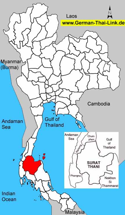
Hi! Great maps for the Thai provinces and German Bundeslaender. Would anything similiar be available for China and/or France? Thanks. olivier 02:59 Mar 8, 2003 (UTC)
- The german maps were created by Cordyph, who created templates for all federal states - I don't know how he created them however. The Thai map I used for Surat Thani province I edited from a map I found in web, and modified it until it was same style as the ones for germany. If I find a good starting map for other countries I can do the same with them for sure. Another way to create such a map is the PanMap software, a free simple GIS tool, and it has the vector data for provincial borders there as well. Sadly the one for France does not use the departement borders, but the province border, but for China it seems to be the right borders. -- andy 15:19 Mar 8, 2003 (UTC)
- I have replied to your comment on my talk page. Thanks! olivier 09:44 Mar 15, 2003 (UTC)
- Thanks. I have replied again. olivier 01:17 Mar 17, 2003 (UTC)
- and again. olivier 13:11 Mar 19, 2003 (UTC)
Of course I don't mind, if you add the maps. I didn't in the last time, because on the weekends I work on a different computer (without a graphics tool). I would have added those maps this week, but if you do it, that is okay as well. -- Cordyph 16:00 Mar 10, 2003 (UTC)
Thanks for the maps. I was really surprised to find them already there :-) -- Cordyph 23:41 Mar 23, 2003 (UTC)
Hi, I wrote the Breisgau-Hochschwarzwald page and like the new standard layout and other additions very much. But I wonder if the list of muncipalities is correct -- as far as I know (and I live there), some five to ten muncipalities have town rights. This includes Breisach, Titisee-Neustadt, Müllheim, Neuenburg and Staufen. -- till we *) 20:29 Apr 25, 2003 (UTC)
- I did that list according to http://www.breisgau-hochschwarzwald.de/landkreis/staeuge/sgtext.htm - and that list only names Breisach and Neuenburg as "Stadt", all others are listed as "Gemeinde". But you are right and that list must be wrong - I just checked at the website of Staufen, and there they call themself "Stadt" as well. Do you have a list which municipalities are cities? Going through all 50 by checking their websites (if they have one) would be a tedious task. andy 20:42 Apr 25, 2003 (UTC)
- Sorry, I don't have such a list. Some of the emails at the URL you quoted start with stadt@ instead of gemeinde@. I'm sure about Staufen, Müllheim and Titisee-Neustadt; it's highly possible that these three plus Breisach and Neuenburg are the only cities. I'll change the page accordingly. -- till we *) 12:07 Apr 26, 2003 (UTC)
I enjoyed your article on Feb 30th, a fascinating idea. Along similar lines, I had a discussion recently about the possiblity of a February with no full moon in it, apparantly Europe had one recently but in New Zealand the full moon was about 2.00am Feb 1st.Ping 11:30 May 13, 2003 (UTC)
- Thanks. You can find more about these so-called Blue Moons in Full moon. andy 11:49 May 13, 2003 (UTC)
Hi,
Nice work on the articles. Concerning the Thai national motto, are you sure it's "Land of smiles"? It sounds more like a tourism pitch or a nickname rather than a national motto.
Erzengel 15:17 May 13, 2003 (UTC)
- I'm not sure either - it was added by LittleDan. I google'd a bit now, and only found the motto of Laos (just added it there), as well as the joke motto mai pen rai (something like it doesn't matter, it's ok). I'll try to investigate more later. andy 15:47 May 13, 2003 (UTC)
My googling unearthed "Nation, Religion, King" as a possible motto. The fact that the tricolor on the Thai flag is meant to represent those things makes it a prime candidate for the motto. It certainly sounds better than the cheesy "Land of smiles" motto anyway. I suspect the motto might be in Sanskrit or Thai, so until I learn those, I can't verify it independently. Erzengel 09:52 May 14, 2003 (UTC)
- OK, I googled with that words now, and found that "Nation, Religion, King" is the official motto of cambodia (see [2], in article 4 of the constitution) - we should remember it when it comes to apply the country template to Cambodia. It was also used as political slogan by Sarith Thanarath in the 1950s, and by several others later, however I cannot find anything yet to prove it's the official motto of the state. andy 10:03 May 15, 2003 (UTC)
I've done a text search of the English translation of the Thai consitution from the Office of Council of State and there appears to be no mention of any official state motto. The constitution I got was dated October 11, BE 2540 (1997 AD), which should be recent enough. You can try your luck there, but the site is really annoying to navigate and uses amateurish javascript ("no copy!"[sic]).
BTW, I've added Cambodia to the list of state mottos.
Erzengel 13:45 15 May 2003 (UTC)
As you are German, I assume you can speak German :-), just need a quick bit of help should this be: "Grosser Sendesaal Des Hessisches Rundfunk" or "Großer Sendesaal Des Heßisches Rundfunk" or even something else? -fonzy
- I am not sure about how it is written after the German spelling reform a few years ago (many ß changed to ss), but the way I would write it is "Großer Sendesaal des Hessischen Rundfunks" (note the genitiv s at the end). andy 11:30 4 Jun 2003 (UTC)
hmmm ok thankyou, one more thing could you translate this please: "Im Wartesaal Zum Großen Glück" and "So geht das jede Nacht" -fonzy
- Sure. "In the waiting-room to the great luck" and "That's the way it goes on every night". But maybe a native english-speaker can create a more lyrical translation of it. andy 12:26 4 Jun 2003 (UTC)
ok thankyou again. - fonzy
Hi, sorry for answering so late, but I was away for almost a month. Yes, you are correct, there is an error in the Rhineland-Palatinate map. I realised that error myself in the district list, but I forgot to check the map. Unfortunately I do not have the template anymore, but keep patient, I will fix it. You've made some great progress in the districts section. I hope, you have something left for me ;-) Cheers -- Cordyph 13:48 4 Jun 2003 (UTC)
- Welcome back, it's much better to work in team on such a project, I felt a bit lost sometimes. While getting up-to-date don't forget to check on the german wikipedia, Baden-Württemberg is already completely covered there with great articles which only need translation and the coat of arms. But don't worry, Bavaria for example is still a white spot on the map :-) andy 13:59 4 Jun 2003 (UTC)
Howdy, thanks for looking over Gundelfingen. Could you clarify what 300 m means? I assume it's 300 meters. --Dante Alighieri 21:54 5 Jun 2003 (UTC)
- Of course, but it need to be reworded as it sounds like nonsense - what is meant is that the center of Gundelfingen is only 300 meter from the city boundary of Freiburg. andy 22:00 5 Jun 2003 (UTC)
- Thanks, I had to translate it myself from the German, and let's just say that my command of German is slightly less than perfect. ;) --Dante Alighieri 22:02 5 Jun 2003 (UTC)
- Your translation was fine, I cross-checked it with the german wikipedia as well and it is same badly written there. Only after I checked with a map I understood what it meant. andy 22:05 5 Jun 2003 (UTC)
Hi, the problem with the RLP map should be solved now. Unfortunately I could not find my original template, and I was not able to reproduce the original colours. In my opinion it looks better now, but it is slightly different from the other maps of federal states. If you have a magic tool to detect the RGB values of the original colours, then you may tell me. -- Cordyph 13:00 6 Jun 2003 (UTC)
- I already fixed it - the original color was #629530. The new color was a bit too dark, it was barely readable - black-on-green isn't a good combination, but at least the old color had a better contrast. And I also reduced the color to 256 which saves about 2k of size. andy 13:08 6 Jun 2003 (UTC)
In case you didn't already know, I've created a group watchlist of sorts at Wikipedia:Favorite pages of banned users to help with tracking when Michael is vandalizing (and any future vandals like him). So feel free too use it, I have already found it helpful, and please add to it when he vandalizes more. Thanks. MB 22:13 6 Jun 2003 (UTC)
Sorry! I wasn't watching what I was doing and reverted the province map of Hebei on accident... Would you mind reuploading the Taiwan version? ^^;;; --Pipian
- Seems it wasn't necessary to re-upload it - I just pressed the revert button again, and got it back that way. andy 07:45 10 Jun 2003 (UTC)
You wrote:
- Yes, this list should (as it does) only list those places officially recognized by any census as a place worth counting. I only haven't found a catchy phrase to add to the article. But that should better be discussed in the talk page there.
I think the main problem is that the list in reality is US-centered in the sense that it starts at the premise that the rest of the world have, with your words, censuses to recognize "places worth counting". It would in my opinion have been a totally unannoying example of lists if it refrained from faulty generalizing (by exstending beyond the area for which its idea obviously was originally thought). As a frequent visitor of Finland, and currently living in Scandinavia, I can imagine millions of places inhabited by less than 10 humans, but who cares? No-one counts them, and no-one distinguish places worth counting from places not worth counting. A list of desserted villages in the Netherlands, or of not yet inhabited lakes in some other specific area, would be of quite another magnitude of interest. :-)))
Please note that I am not in any way concerned by this particular list, but in the existence of lists doing, in my view, ridiculous claims. Particularly lists of openended sets which, as you know, per definition never can be complete. I do not believe such lists ever to become corrected. Particularly not when they've grown to impressive sizes. To make corrections require much more work than to revert the corrections. Compare the List of ethnic groups where plenty of items are dubious in one or another way (transliteration, transcription, confusion of nationality versus ethnicity, of inhabitants of present-day entities with historical tribes, of nationality versus citizenship, etc, etc.). If someone would make corrections or qualifications, it would rather be in the articles, not in the very long lists.
-- Ruhrjung 00:13 14 Jun 2003 (UTC)
Hi Andy -- I actually did look at the talk page on Odra. I'm changing it regardless and putting in an explanation. I helped to write the naming conventions (I used to be a wikipedeholic, and am only making a few changes until I can get someone to remove me entirely from the site -- that's another story). The official English name is Oder. That's how it should be. If you want to look at a record of my contributions, you'll see that I'm pretty consistent in things like this -- and that I've often taken the "other side" of the German/Polish issue. I also have argued for using names that are more common in scholarly works, even if not yet in common parlance -- but that is a matter of reflecting a change in customary use, rather than official use. JHK
- I did only see an edit by an anonymous user (seems like you aren't logged in), and I remember it did take long to get to the consensus about the current naming of the Odra. Thus I reverted your moving of the contents, as there was absolutely no mention about a reason on the Talk page. I would suggest you wait to move it until after some discussion there, this seems to be a sensible topic for the polish. andy 14:50 17 Jun 2003 (UTC)
Did you mean sinnvoll? That's "sensitive", not "sensible". The only reason you missed the explanation is that I was in the middle of working on edits to make the Oder article clearer without making it seem that there is contention over the name. The only point of contention is here -- not in the wider world. In the wider world, people refer to things in their own language or by local names. Here, we try to stick to official English names or widest English-language usage. By looking at the article as I've changed it, it's clear that the river has other names in other languages, and that one might not always see Oder. But it's misleading to imply that the two are interchangeable in English. JHK not logged in as part of a general protest
- Oups, I hate these false friends. Of course I meant "sensitive" (german sensibel). I have no objections to calling the river Oder, as a german I am more familiar with that spelling anyway. I just worry it will have the same edit war again it had before. andy 15:10 17 Jun 2003 (UTC)
- Yes, the edit war will return for sure. Some months ago I tried to find a compromise, as it seemed to be extremely important for some Polish wikipedians to see that article under the Polish name. The agreement was to place Oder River under its Polish and Oder-Neisse line under its German name - but it has never been fully translated into action, as you can see in various articles. As far as I'm concerned, it doesn't make any difference for me, what the river is called - but there was a situation, that many of my own edits were reverted by Taw and co. with comments like "Helga fix" or "reverting revanchism", and all they did was changing "Oder" to "Odra". Since I regard myself as anti-fascist and sensitive to that topic, I was quite upset and got sticked in the dispute. But I decided, that I wouldn't lose anymore time with a stupid naming discussion, if it should come up again.
- To Julie: When I say "stupid", I don't mean you, but people insisting on calling a place by its "only true name". We have these discussions all over Wikipedia, in articles like Republic of Macedonia or Sea of Japan (where we now have an article Dispute over the name Sea of Japan - probably we should create such an article for the Oder river as well, it would be a new playground for the fundamentalists, where they can let off steam ;-) ). And I am really, really tired of it. Cheers -- Cordyph 08:19 18 Jun 2003 (UTC)
Thanks for correcting the break in numbering. Mozilla does that sometimes and I fail to notice. Koyaanis Qatsi 18:44 24 Jun 2003 (UTC)
- I wanted to fix the missing ] you forgot - and after saving I noticed the break. But it wasn't your Mozilla it did it, it was the anonymous edit before which broke it. andy 18:48 24 Jun 2003 (UTC)