
User talk:Shannon1
| ^...^ This is Shannon1's talk page. For DYK, please put the template on the DYK page. |
Your GA nomination of Trinity River (California)[edit]
Hi there, I'm pleased to inform you that I've begun reviewing the article Trinity River (California) you nominated for GA-status according to the criteria. ![]() This process may take up to 7 days. Feel free to contact me with any questions or comments you might have during this period. Message delivered by Legobot, on behalf of Coemgenus -- Coemgenus (talk) 14:01, 3 February 2017 (UTC)
This process may take up to 7 days. Feel free to contact me with any questions or comments you might have during this period. Message delivered by Legobot, on behalf of Coemgenus -- Coemgenus (talk) 14:01, 3 February 2017 (UTC)
Your GA nomination of Trinity River (California)[edit]
The article Trinity River (California) you nominated as a good article has been placed on hold ![]() . The article is close to meeting the good article criteria, but there are some minor changes or clarifications needing to be addressed. If these are fixed within 7 days, the article will pass; otherwise it may fail. See Talk:Trinity River (California) for things which need to be addressed. Message delivered by Legobot, on behalf of Coemgenus -- Coemgenus (talk) 14:20, 6 February 2017 (UTC)
. The article is close to meeting the good article criteria, but there are some minor changes or clarifications needing to be addressed. If these are fixed within 7 days, the article will pass; otherwise it may fail. See Talk:Trinity River (California) for things which need to be addressed. Message delivered by Legobot, on behalf of Coemgenus -- Coemgenus (talk) 14:20, 6 February 2017 (UTC)
Your GA nomination of Trinity River (California)[edit]
The article Trinity River (California) you nominated as a good article has passed ![]() ; see Talk:Trinity River (California) for comments about the article. Well done! If the article has not already been on the main page as an "In the news" or "Did you know" item, you can nominate it to appear in Did you know. Message delivered by Legobot, on behalf of Coemgenus -- Coemgenus (talk) 16:23, 9 February 2017 (UTC)
; see Talk:Trinity River (California) for comments about the article. Well done! If the article has not already been on the main page as an "In the news" or "Did you know" item, you can nominate it to appear in Did you know. Message delivered by Legobot, on behalf of Coemgenus -- Coemgenus (talk) 16:23, 9 February 2017 (UTC)
DYK for Oroville Dam crisis[edit]
On 28 February 2017, Did you know was updated with a fact from the article Oroville Dam crisis, which you recently created, substantially expanded, or brought to good article status. The fact was ... that nine million fish were rescued from the Feather River Fish Hatchery during the 2017 Oroville Dam crisis (pictured)? You are welcome to check how many page hits the article got while on the front page (here's how, Oroville Dam crisis), and it may be added to the statistics page if the total is over 5,000. Finally, if you know of an interesting fact from another recently created article, then please feel free to suggest it on the Did you know talk page.
In your edit summardddddddddddddddddddddarticle itself has no sources. why remove new content without even confirming it?" I remove it for the same reason I pick up litter in my neighborhood; because if it builds it sends a message to the community that nobody cares, and leads to more litter. The broken windows theory follows this philosophy. I will often look for a source for a new editor who wishes to add something valuable to the project but has little ability to properly source their edit. For an experienced editor, who for whatever reason wishes to add significant content without taking the time to find a source--or worse, expects others to find it for them--I delete like a ninja. Magnolia677 (talk) 23:33, 28 March 2017 (UTC)
- I suppose it would be petty, but in this situation it might also be good to give the original poster a friendly reminder. It doesn't do much good to just revert their edit, they probably wouldn't find out anyway. Shannon 00:21, 30 March 2017 (UTC)
- If they use Twinkle it notify them of a reverted edit. Also, I left this reminder with the editor six months ago. Magnolia677 (talk) 03:36, 30 March 2017 (UTC)
File:Doloresrivermap.png[edit]
Dosen't "west fork" in this map should be "West Dolores River"?--Htmlzycq (talk) 23:52, 26 May 2017 (UTC)
Invitation to San Diego wiknic and bonfire[edit]
![]() You are invited to join the discussion at Wikipedia:Meetup/San Diego/July 2017 Wiknic . RightCowLeftCoast (talk) 01:18, 31 May 2017 (UTC)
You are invited to join the discussion at Wikipedia:Meetup/San Diego/July 2017 Wiknic . RightCowLeftCoast (talk) 01:18, 31 May 2017 (UTC)
Yarlung Tsangpo map[edit]
Hello! I just noticed on the map File:Yarlungtsangpomap.png that the Yarlung Tsangpo River is shown to extend 500km further west than its actual source, located approximately where the "u" is in the word "Yarlung". Is there any chance this map could be updated? Alternatively, if you have the original source file, I could attempt to fix this. Let me know what you think is best. Thanks! --NoGhost (talk) 21:53, 1 September 2017 (UTC)
- Thanks for letting me know - that's a really old map and I've been working on replacing my old maps anyway. I'll move that up to the front of the list. Shannon 00:19, 2 September 2017 (UTC)
Hi Shannon. Would you mind explaining what led you to create this article? It's just that only one month earlier, a user who was later blocked as part of Orangemoody editing of Wikipedia/Wikipedia:Long-term abuse/Orangemoody, created User:Manc1234/Angus Knowles-Cutler. This is either a bizarre coincidence, or you been persuaded somehow (presumingly unwittingly) to add their content to Wikipedia. Thanks SmartSE (talk) 16:15, 6 November 2017 (UTC)
- @Smartse: Um, well, I posted the article to return a favor for someone I know, and the subject looked notable enough to me. If that's not allowable I'll refrain from doing that in the future, but could you please clarify what all this is about? Shannon [ Talk ] 22:29, 6 November 2017 (UTC)
- This could possibly be part of an on-going investigation into some particularly nefarious activity, or then again, it might not be. With your good and long record of editing there is almost certainly nothing for you to be concerned about, although editing by proxy is not allowed. Kudpung กุดผึ้ง (talk) 22:50, 6 November 2017 (UTC)
- Ok- understood. It's been a while since I last got involved in any wikipedia drama. I'm just surprised that turned out to be part of some organized wiki-crime ring... Shannon [ Talk ] 23:09, 6 November 2017 (UTC)
- Thanks for replying Shannon. I'd like to reiterate what Kudpung said about there being no concern about you directly, it's just that this is rather odd and I would like to understand what's been going on more fully. As you can see from the links I listed before, the Orangemoody operation have been involved in various nefarious activities. It's not just that they are writing articles for pay without disclosing that this is the case, as required by WP:PAID but they have been blackmailing article subject's as well. They're clearly still active here despite being banned and I think it is important to understand if their tactics are changing. The main reason to ask you about what led you to create the article was that I was concerned that you'd somehow been tricked into doing so. That doesn't seem to be the case considering you've said that you did it as a favour, but I think I am correct in saying that you didn't write the content yourself? If I'm right, didn't you think it a bit odd that your acquaintance couldn't just post it themselves? Are you still sure you weren't somehow manipulated into doing this? If you'd prefer not to reply in public then please drop me an email. (And as an aside, they are unlikely to meet WP:BIO but we'll need to mull that over at AFD). Thanks SmartSE (talk) 22:36, 7 November 2017 (UTC)
- Ok- understood. It's been a while since I last got involved in any wikipedia drama. I'm just surprised that turned out to be part of some organized wiki-crime ring... Shannon [ Talk ] 23:09, 6 November 2017 (UTC)
- He asked me because he knows I have experience editing here. I did modify the content to "wikify" it as a whole - formatting references, copyediting, etc. If you'd like to know exactly why, I do some freelance writing online for this agent which sends work to a bunch of different writers. I had a scheduling kerfuffle one day and another writer helped me finish my ongoing project so I offered to do them a favor later, that happened to be working on a Wikipedia article. I had originally got the writing job by linking to things I previously published, including Wikipedia pages, so they know I edit here.
- I don't edit Wikipedia for pay out of principle but no money was changing hands in that case. I've made a few other edits here and there in the past, can't remember off the top of my head which articles though, but I didn't think it was for anything nefarious - sorry if I've broken some wiki regulations so I'll just say no next time someone asks me to edit for them... I'm happy to further discuss via email if you want, I didn't imagine my agent might be involved in this sort of case (the Wikipedia mafia?).
- Cheers, Shannon [ Talk ] 01:01, 8 November 2017 (UTC)
- Thanks for the detailed explanation. I hope you don't mind my prying but I feel it's important to try and keep track how the PR industry manages to get their content added here. From what you say it sounds relatively unlikely that it was Orangemoody and one explanation is that the subject wanted an article and ended up hiring someone else to do it after Manc1234 was blocked. Through more investigations though I came across almost the exact same version that you posted here: Special:Undelete/User:Silver_Penguin/sandbox (you won't be able to see, but Kudpung will). You also reviewed Bilal Hashmat (which also has the distinct odour of undisclosed paid editing) created by the same user only minutes after it was created back in 2016. That basically gave the article a free pass at new page patrol and meant that no one else looked at it and had a chance to notice the terrible sources cited. To reiterate, > 99 % of what you've done here is great work here, but please don't do any more favours for anyone. SmartSE (talk) 21:07, 8 November 2017 (UTC)
- @Smartse: Oh, yeah, I remember those -- so am I required to wear the COI badge of shame on my talk page now or would these be considered 'minor infractions'? Admittedly my attitude towards 'editing by proxy' has been a bit too casual, I'm sorry if I perceived it as harmless. I've let my contact know I will no longer do anything related to editing Wikipedia, so no more shenanigans from me in the future...Shannon [ Talk ] 22:15, 8 November 2017 (UTC)
A barnstar for you![edit]

|
The Graphic Designer's Barnstar |
| I'm a huge fan of your maps! Great work shannon :) Nadouglass (talk) 05:06, 13 November 2017 (UTC) |
- Thank you! Really appreciated. Any map in particular? Shannon [ Talk ] 22:37, 13 November 2017 (UTC)
Your GA nomination of Stanislaus River[edit]
Hi there, I'm pleased to inform you that I've begun reviewing the article Stanislaus River you nominated for GA-status according to the criteria. ![]() This process may take up to 7 days. Feel free to contact me with any questions or comments you might have during this period. Message delivered by Legobot, on behalf of Mnnlaxer -- Mnnlaxer (talk) 19:01, 25 November 2017 (UTC)
This process may take up to 7 days. Feel free to contact me with any questions or comments you might have during this period. Message delivered by Legobot, on behalf of Mnnlaxer -- Mnnlaxer (talk) 19:01, 25 November 2017 (UTC)
Your GA nomination of Stanislaus River[edit]
The article Stanislaus River you nominated as a good article has passed ![]() ; see Talk:Stanislaus River for comments about the article. Well done! If the article has not already been on the main page as an "In the news" or "Did you know" item, you can nominate it to appear in Did you know. Message delivered by Legobot, on behalf of Mnnlaxer -- Mnnlaxer (talk) 16:02, 30 November 2017 (UTC)
; see Talk:Stanislaus River for comments about the article. Well done! If the article has not already been on the main page as an "In the news" or "Did you know" item, you can nominate it to appear in Did you know. Message delivered by Legobot, on behalf of Mnnlaxer -- Mnnlaxer (talk) 16:02, 30 November 2017 (UTC)
ArbCom 2017 election voter message[edit]
Hello, Shannon1. Voting in the 2017 Arbitration Committee elections is now open until 23.59 on Sunday, 10 December. All users who registered an account before Saturday, 28 October 2017, made at least 150 mainspace edits before Wednesday, 1 November 2017 and are not currently blocked are eligible to vote. Users with alternate accounts may only vote once.
The Arbitration Committee is the panel of editors responsible for conducting the Wikipedia arbitration process. It has the authority to impose binding solutions to disputes between editors, primarily for serious conduct disputes the community has been unable to resolve. This includes the authority to impose site bans, topic bans, editing restrictions, and other measures needed to maintain our editing environment. The arbitration policy describes the Committee's roles and responsibilities in greater detail.
If you wish to participate in the 2017 election, please review the candidates and submit your choices on the voting page. MediaWiki message delivery (talk) 18:42, 3 December 2017 (UTC)
Karun map[edit]
Hello. Looks like source of the river drawn incorrect at this map. It should be somewhere here: 32°36′07″N 49°54′57″E / 32.60207°N 49.91587°E. References: [1], [2]. Please, fix it if you can. — Vort (talk) 15:00, 7 January 2018 (UTC)
- Hi- sorry for the late response! I intend to make a full replacement for that map though it might be a while. Will try to do as soon as possible though. Shannon [ Talk ] 06:43, 20 January 2018 (UTC)
I want to make watershed maps and may need some guidance[edit]
So I've taken the plunge and really started learning how to use QGIS and Inkscape and all these data sources. (I had been working on this thing unrelated to Wikipedia but now I want to learn more about each individual basin starting with the largest... and what better way than to create free maps when there aren't any good ones?)
I see you're perhaps the largest (only?) source of fresh new drainage basin maps coming into Wikimedia Commons right now, so here's a few ways you could help me:
- It'd be nice if I knew which areas you were planning to work on next, so we don't accidentally spend effort on duplicate maps (although that wouldn't be a disaster). I'm thinking of doing Yangtze River first.
- When I upload my first maps, could you give me a review (tell me what sucks about them)?
- As I go I might have questions about your workflow - I have two already:
- Taking File:Mackenzie River basin map.png as an example, how do you make the drainage basin polygon pop out like that? Is it just a layer that's black
outsideinside the drainage basin and transparentinsideoutside, with a low opacity? - How do you get the text of the river names to curve gracefully like that? Is it all manual or is there some automatic way to get started? —Keenan Pepper 18:37, 18 January 2018 (UTC)
- Taking File:Mackenzie River basin map.png as an example, how do you make the drainage basin polygon pop out like that? Is it just a layer that's black
- Hi Keenan - I'm glad you're interested! I finish most of my maps in Adobe Illustrator, however so I'm not particularly familiar with Inkscape. But the processes should be similar. In regard to your questions, I basically do the drainage basin as a darker shape against a white background before layering the shaded relief on top (the relief layer has to be partially transparent, of course). To curve the text there is a "type on a path" tool in Illustrator and I would assume something similar is available in Inkscape, you'd just have to look at their documentation to find the exact tool. Note that saving in a SVG format tends to screw up the curved text, and I haven't found a way around that yet.
- Right now I'm mostly doing rivers in North America, though I'm considering doing replacements for some of the Southeast Asia rivers (Mekong, Salween, Irrawaddy) in the near future.
- I'd be happy to take a look at your maps, just send me a link whenever you upload. Cheers, Shannon [ Talk ] 20:06, 18 January 2018 (UTC)
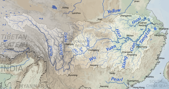
Yangtze river map[edit]
I'd welcome any comments. —Keenan Pepper 17:58, 20 January 2018 (UTC)
- The color scheme and linework look very nice, though the variation on the river widths is a bit too much IMO. The text on the other hand could use some refining - did you figure out how to use curved text in Inkscape? - and the country labels seem somewhat too big and dark. Content-wise it looks accurate, except what you have labeled the Min River is actually the Dadu River, a tributary of the Min (see Kmusser's older map here). Overall, though, good work! Shannon [ Talk ] 03:55, 21 January 2018 (UTC)
- I just wanted to pop in and say if either of you want to re-make any of my China river maps feel free, while I think the rivers are correct, the province border layer I used as a background has lots of errors so they could really use it, but I don't think I'll get a chance to do so any time soon. Kmusser (talk) 14:54, 23 January 2018 (UTC)
- To Keenan, I think the map looks great, I think my only nitpick would be to italicize the river labels, it's a common mapping convention to italicize natural features (rivers, mountains, etc.) to help differentiate them from cities, countries, provinces, etc. I might fudge the basin boundary near the Yellow river so it's clearer that the Yellow doesn't enter it. Kmusser (talk) 15:03, 23 January 2018 (UTC)
- Sweet, Kmusser showed up! It turned out that the HydroSHEDS data I was using was not compatible with Commons (it has some dumb clause against "reverse engineering"), so I had to kind of start over with USGS Hydro1k data instead. I had to learn about Pfafstetter coding and how to use QGIS with different map projections... but now I'm all set up. Here's the new version of the Yangtze: —Keenan Pepper 05:20, 2 February 2018 (UTC)
- Sweet, Kmusser showed up! It turned out that the HydroSHEDS data I was using was not compatible with Commons (it has some dumb clause against "reverse engineering"), so I had to kind of start over with USGS Hydro1k data instead. I had to learn about Pfafstetter coding and how to use QGIS with different map projections... but now I'm all set up. Here's the new version of the Yangtze: —Keenan Pepper 05:20, 2 February 2018 (UTC)

![[2]](https://legacy.lib.utexas.edu/maps/ams/iraq_and_iran/txu-pclmaps-oclc-6589753-shahr-kurd-i-39-u.jpg)
- Looks a lot better. I'm aware of the strict limitations of SVG fonts but the river labels don't quite look right (compare with the Min River map I linked above - maybe just dull the color a little bit and play around with the available fonts?) Also I wasn't aware that HydroSHEDS wasn't public domain, I was under the false impression it came from USGS data; I've been using it for reference, so thanks for bringing that up! Shannon [ Talk ] 20:33, 2 February 2018 (UTC)
Map making assistance[edit]
Please reach out if you need any assistance with river/watershed maps. I have quite a bit of digital map making experience and work in hydrology. Love your work so far! W Scott Lincoln 00:12, 7 June 2018 (UTC)
- Hello, thanks for contacting me! I'm traveling right now but I will definitely reach out to you via email when I get back in a few days. I intend to work in hydrology as related to natural resources, so I would love some advice. Shannon [ Talk ] 19:13, 7 June 2018 (UTC)
Your GA nomination of Kaweah River[edit]
Hi there, I'm pleased to inform you that I've begun reviewing the article Kaweah River you nominated for GA-status according to the criteria. ![]() This process may take up to 7 days. Feel free to contact me with any questions or comments you might have during this period. Message delivered by Legobot, on behalf of Ceranthor -- Ceranthor (talk) 17:40, 12 July 2018 (UTC)
This process may take up to 7 days. Feel free to contact me with any questions or comments you might have during this period. Message delivered by Legobot, on behalf of Ceranthor -- Ceranthor (talk) 17:40, 12 July 2018 (UTC)
Your GA nomination of Kaweah River[edit]
The article Kaweah River you nominated as a good article has passed ![]() ; see Talk:Kaweah River for comments about the article. Well done! If the article has not already been on the main page as an "In the news" or "Did you know" item, you can nominate it to appear in Did you know. Message delivered by Legobot, on behalf of Ceranthor -- Ceranthor (talk) 17:22, 14 August 2018 (UTC)
; see Talk:Kaweah River for comments about the article. Well done! If the article has not already been on the main page as an "In the news" or "Did you know" item, you can nominate it to appear in Did you know. Message delivered by Legobot, on behalf of Ceranthor -- Ceranthor (talk) 17:22, 14 August 2018 (UTC)
Danube cycloid[edit]
Hello Shanon, Could You do some maps of three phase cycloid Danube propagation and paleodynamics for open sci article. It would be great breakthrough. After we can use it on Commons. Best, Lepota luba cosmo lepota.cosmo@hotmail.com--178.222.63.132 (talk) 14:57, 31 August 2018 (UTC)
Your GA nomination of Kings River (California)[edit]
Hi there, I'm pleased to inform you that I've begun reviewing the article Kings River (California) you nominated for GA-status according to the criteria. ![]() This process may take up to 7 days. Feel free to contact me with any questions or comments you might have during this period. Message delivered by Legobot, on behalf of Ceranthor -- Ceranthor (talk) 17:01, 10 September 2018 (UTC)
This process may take up to 7 days. Feel free to contact me with any questions or comments you might have during this period. Message delivered by Legobot, on behalf of Ceranthor -- Ceranthor (talk) 17:01, 10 September 2018 (UTC)
A barnstar for you![edit]

|
The Random Acts of Kindness Barnstar |
| You seem like a good editor, so, here, take a barnstar! (Also, if you feel like it, you can return the favor) TheBoiZurkelman (talk) 14:16, 2 October 2018 (UTC) |
Your GA nomination of Kings River (California)[edit]
The article Kings River (California) you nominated as a good article has passed ![]() ; see Talk:Kings River (California) for comments about the article. Well done! If the article has not already been on the main page as an "In the news" or "Did you know" item, you can nominate it to appear in Did you know. Message delivered by Legobot, on behalf of Ceranthor -- Ceranthor (talk) 13:02, 15 October 2018 (UTC)
; see Talk:Kings River (California) for comments about the article. Well done! If the article has not already been on the main page as an "In the news" or "Did you know" item, you can nominate it to appear in Did you know. Message delivered by Legobot, on behalf of Ceranthor -- Ceranthor (talk) 13:02, 15 October 2018 (UTC)
Infobox River[edit]
I really want to thank you for your comments. You made me eat a big slice of humble pie, but made a really great point and I appreciate the way that you did it. I honestly was pretty dismissive of your original post, partially because I was engaged in an WP:ANI with someone that was really getting to me... But when I stepped back and looked at it, you are spot on. So bottom line, thank you!! --Zackmann (Talk to me/What I been doing) 22:45, 22 October 2018 (UTC)
- Take a look at Template:Infobox river/testcases... Let me know what you think. --Zackmann (Talk to me/What I been doing) 01:23, 23 October 2018 (UTC)
- @Zackmann08: Looks great! One nitpick, though, is it possible to make the tabs (such as beneath "width" and "discharge") not bolded? Or is it hard-coded into the infobox? Shannon [ Talk ] 17:37, 23 October 2018 (UTC)
- Honestly, not sure... I can investigate! --Zackmann (Talk to me/What I been doing) 18:11, 23 October 2018 (UTC)
- @Zackmann08: Looks great! One nitpick, though, is it possible to make the tabs (such as beneath "width" and "discharge") not bolded? Or is it hard-coded into the infobox? Shannon [ Talk ] 17:37, 23 October 2018 (UTC)
What action to take re Infobox river / Geobox river Tfd/merge[edit]
Really would like your insights at User talk:Qui1che#Gauge interest in pursuing dispute resolution re the Geobox river / Infobox River Tfd and merge process. --papageno (talk) 00:42, 16 November 2018 (UTC)
ArbCom 2018 election voter message[edit]
Hello, Shannon1. Voting in the 2018 Arbitration Committee elections is now open until 23.59 on Sunday, 3 December. All users who registered an account before Sunday, 28 October 2018, made at least 150 mainspace edits before Thursday, 1 November 2018 and are not currently blocked are eligible to vote. Users with alternate accounts may only vote once.
The Arbitration Committee is the panel of editors responsible for conducting the Wikipedia arbitration process. It has the authority to impose binding solutions to disputes between editors, primarily for serious conduct disputes the community has been unable to resolve. This includes the authority to impose site bans, topic bans, editing restrictions, and other measures needed to maintain our editing environment. The arbitration policy describes the Committee's roles and responsibilities in greater detail.
If you wish to participate in the 2018 election, please review the candidates and submit your choices on the voting page. MediaWiki message delivery (talk) 18:42, 19 November 2018 (UTC)
Oraibi Wash?[edit]


Shannon, great work on the maps. I got a shot of an ephemeral tributary of the Little Colorado River, which I think is Oraibi Wash, but it doesn't appear on your map. I think it converges with the Polacca Wash near Tolani Lake, Arizona. Here it is on Google Maps. I can only find fragmental info on these things (Google Maps doesn't show the wash names). Maybe you can find better. Dicklyon (talk) 01:41, 10 December 2018 (UTC)
I also got shots of File:Polacca Wash.jpg (to the east) and File:Dinnebito Wash.jpg (to the west) that seem to match your map. Dicklyon (talk) 03:05, 10 December 2018 (UTC)
Here I found a presenation with maps that agree with what I think I figured out. Is that helpful to you in updating your map? Dicklyon (talk) 04:06, 10 December 2018 (UTC)
- Thanks for providing the photos! That is an older map of mine and I intend to replace it at some point. Many of those washes are actually labeled on USGS topo maps if you're interested... there's a whole bunch of them in that area! Shannon [ Talk ] 23:57, 11 December 2018 (UTC)

I also got a few aerials of tributaries from the south of the Little Colorado, with sources in the Mogollon Rim area, which are shown in your Salt River map. See Clear Creek (Little Colorado River tributary) and Chevelon Creek. Dicklyon (talk) 23:36, 23 September 2019 (UTC)
Follow-up note[edit]
I thought I would add that I've been largely inactive for about a year, and I've missed some important changes such as the disappearance of the geobox. My editing time is limited, so I've been doing easy things, nibbles and flybys, hence the overlink removals and map adjustments. I'm very happy that you and others continue to add content. Please keep up the good work. Finetooth (talk) 20:47, 21 January 2019 (UTC)
- I also have my regrets about the geobox, but the anti-geobox crowd way outnumbered the "rivers editors" this time... all I could really do was push to save some features from geobox. Wasn't perfect but I think it was an ok compromise. It's always great to hear from you; hope to see you around a bit more if time allows! Shannon [ Talk ] 00:32, 22 January 2019 (UTC)
Syrian rivers[edit]
Hello Shannon, how are you? I hope fine. I like your river maps and therefore I wanted to ask you, if you can draw some maps for the syrian rivers like the Khabur (Euphrates), Balikh River and the Afrin River. It would be a pleasure. Best regards.KureCewlik81 (talk) 02:22, 24 March 2019 (UTC)
- hello, do you have time to answer? Warm greetings.KureCewlik81 (talk) 14:46, 24 September 2019 (UTC)
Colorado River (Argentina)[edit]
Hi, Shannon1!
Thanks for your wonderful work. Let me point out that there is a mistake in the Colorado River (Argentina) map: the province east of the Desaguadero is not Mendoza but San Luis. Mendoza is the province west of the Desaguadero river, south of the San Juan province. See e.g. the map in Provinces of Argentina. Thank you, 181.171.182.205 (talk) 16:47, 25 May 2019 (UTC) (used to be User:Cinabrium eons ago).
- Thanks for letting me know, I have fixed the label. Good catch! Shannon [ Talk ] 04:17, 27 May 2019 (UTC)
Speedy deletion nomination of Category:Dams completed in the 21st century[edit]

A tag has been placed on Category:Dams completed in the 21st century requesting that it be speedily deleted from Wikipedia. This has been done under section C1 of the criteria for speedy deletion, because the category has been empty for seven days or more and is not a disambiguation category, a category redirect, a featured topics category, under discussion at Categories for discussion, or a project category that by its nature may become empty on occasion.
If you think this page should not be deleted for this reason, you may contest the nomination by visiting the page and clicking the button labelled "Contest this speedy deletion". This will give you the opportunity to explain why you believe the page should not be deleted. However, be aware that once a page is tagged for speedy deletion, it may be deleted without delay. Please do not remove the speedy deletion tag from the page yourself, but do not hesitate to add information in line with Wikipedia's policies and guidelines. Liz Read! Talk! 01:09, 27 August 2019 (UTC)
Colorado River[edit]
I noticed a error on File:Colorado_River_basin_map.png, it's including a small closed basin in Wyoming in the Colorado basin, namely HUC 14040200 "Great Divide Closed Basin" [3]. That section of the boundary was correct on your old map. Also as an aside, feel free to remove my old super simple maps once a detailed map is done, I found one still up on the Delaware River page. They were made for rivers that had no map at all and I think they're redundant once they have a better map. Kmusser (talk) 19:38, 19 September 2019 (UTC)
- Hey, thanks for bringing this up – although I seem to remember for some reason, the Great Divide Basin is often included in the Colorado River watershed. A quick image search shows some maps including the basin (like this) and some that don't (like this). You are right though that the basin doesn't actually drain into the Colorado. I'll get that fixed! Shannon [ Talk ] 04:55, 20 September 2019 (UTC)
- Thanks, it's easy to do because if you're using the USGS HUC2 or HUC4 layers it'll get lumped in with the Colorado automatically, USGS has a tendency to lump small closed basins in with a convenient adjacent basin rather than leaving holes in their generalized maps. Kmusser (talk) 21:14, 20 September 2019 (UTC)
I see you created this article. I'm staying in the neighborhood, so got some photos for it. Anything else you'd like to see from Pagosa Springs area while I'm here? Maybe start Little Navajo River with some photos? Dicklyon (talk) 17:28, 21 September 2019 (UTC)
Started. Needs work on all the template details, which I might get to later. Dicklyon (talk) 18:42, 21 September 2019 (UTC)
- Thanks for that- I may start filling in the infobox unless you get to it first. Speaking of nearby features that don't have a photo, I found: Florida River, Mancos River, Rio Grande Dam, Rio San Antonio (Colorado) (doesn't have an article either), and La Plata River (San Juan River tributary) could probably do with a better picture as well. It's a cool area! Definitely hope to explore it sometime.Shannon [ Talk ] 21:27, 21 September 2019 (UTC)
- I won't have time to get that far from Pagosa Springs on this trip. Maybe the Florida, when we head to Durango airport. Lots of pictures of the San Juan of course. I've got a dozen or so more good aerials to upload, like of the Animas. And lots of "ColorFest" balloon festival shots of the San Juan. Dicklyon (talk) 03:26, 22 September 2019 (UTC)
I made it by Devil Creek, Los Pinos River, and Florida River this morning; good thing my flight is running late. Yesterday I bagged Sheep Cabin Creek, Lefthand Creek, Catchpole Creek, Wolf Creek (Mineral County, Colorado), Fall Creek, and the East and West Forks of the San Juan River. The day before, Stollsteimer Creek and Piedra River, including a pano of both of their valleys from Chimney Rock National Monument. I've got a few days or weeks of selecting and uploading ahead of me when I get home. Dicklyon (talk) 17:24, 24 September 2019 (UTC)
On the flight to PHX I got the Florida River, Animas River, La Plata River (San Juan River tributary), Chaco River and its confluence with the San Juan at Shiprock and the Four Corners Power Plant, Black Creek, Rye Creek, Tonto Creek, and more. Dicklyon (talk) 19:07, 25 September 2019 (UTC)
- Nice! Looking forward to seeing the pictures. And there's definitely a lot of streams out there with short or nonexistent articles such as the ones you mentioned; I may look into it once things settle down and I have more time to edit again. Shannon [ Talk ] 06:54, 26 September 2019 (UTC)
- Check out Florida River and La Plata River (San Juan River tributary) and Piedra River (Colorado), and/or User:Dicklyon#Pagosa_Springs_trip. Dicklyon (talk) 22:27, 26 September 2019 (UTC)
- About done uploading. Got some between PHX and SJC, too. See User:Dicklyon#Pagosa_Springs_trip. Dicklyon (talk) 05:26, 1 October 2019 (UTC)
A barnstar for you![edit]
|
|
The Graphic Designer's Barnstar |
| All of your maps are awesome references for California's rivers! I hope you never stop making them.
P.S. one of your links in the first paragraph is broken. Ajtech31 (talk) 00:41, 29 September 2019 (UTC) |
- Thank you! There's definitely a ton left to make or update. Also you're right about the link :[ got to find a new picture... Shannon [ Talk ] 23:53, 8 October 2019 (UTC)
2019 US Banknote Contest[edit]
| US Banknote Contest | 
| |
|---|---|---|
| November-December 2019 | ||
|
There are an estimated 30,000 different varieties of United States banknotes, yet only a fraction of these are represented on Wikimedia Commons in the form of 2D scans. Additionally, Colonial America, the Confederate States, the Republic of Texas, multiple states and territories, communities, and private companies have issued banknotes that are in the public domain today but are absent from Commons. In the months of November and December, WikiProject Numismatics will be running a cross-wiki upload-a-thon, the 2019 US Banknote Contest. The goal of the contest is to increase the number of US banknote images available to content creators on all Wikimedia projects. Participants will claim points for uploading and importing 2D scans of US banknotes, and at the end of the contest all will receive awards. Whether you want to claim the Gold Wiki or you just want to have fun, all are invited to participate. If you do not want to receive invitations to future US Banknote Contests, follow the instructions here | ||
Sent by ZLEA at 23:30, 19 October 2019 (UTC) via MediaWiki message delivery (talk)
ArbCom 2019 election voter message[edit]
Aras river map[edit]
Greetings,
I've noticed an issue on commons:File:Arasrivermap.jpg which was flagged on its talk page - the map suggests that Lake Çıldır drains into the Karahan River but from maps it looks like it actually runs into the Akhurian River. Jo-Jo Eumerus (talk) 14:17, 17 February 2020 (UTC)
- Something along the same lines, I am not sure that the catchment of the Ash Creek in File:Virginrivermap.jpg goes that far north. Jo-Jo Eumerus (talk) 16:07, 9 March 2020 (UTC)
South Platte[edit]
Hi — thanks for all the lovely watershed maps. I think a tributary of the South Platte may be mis-labeled on that image — see its talk page for details. Thanks! Doops | talk 15:31, 30 April 2020 (UTC)
Request for higher resolution image: Saskatchewan basin map.png[edit]
Thanks for your maps they are very useful. In fact my employers are hoping to use this one "File:Saskatchewan basin map.png" at https://en.wikipedia.org/wiki/Saskatchewan_River#/media/File:Saskatchewan_basin_map.png in a forthcoming publication (book). We were wondering if you would have available or be able to easily make a higher resolution (aiming for 300dpi) version of this map we could use, and if so what the correct citation would then be? Thanks -Chris Wight Communications — Preceding unsigned comment added by BartimaeusCooperative (talk • contribs) 00:53, 15 May 2020 (UTC)
- I do have a higher resolution version available. I can send it to you by email; what would be a good address? Shannon [ Talk ] 01:25, 15 May 2020 (UTC)
Thanks so much, please forward to inquiries@bcm-net.org attn: Chris Wight or wightc01@gmail.com — Preceding unsigned comment added by BartimaeusCooperative (talk • contribs) 23:46, 19 May 2020 (UTC)
ArbCom 2020 Elections voter message[edit]
Thanks for your Potter Valley Project map[edit]
Just a quick note to say that your map of the Potter Valley Project in northern California is wonderfully clear and quickly communicates what this water transfer project does. Thanks for all your work! Rupert Clayton (talk) 17:19, 28 December 2020 (UTC)
Orphaned non-free image File:OC Streetcar Logo.svg[edit]

Note that any non-free images not used in any articles will be deleted after seven days, as described in section F5 of the criteria for speedy deletion. Thank you. --B-bot (talk) 18:48, 4 February 2021 (UTC)
Software used for Salton Sea drainage map[edit]
I saw commons:File:Saltonseadrainagemap.jpg recently. I like it, and it was very useful. I vaguely recall seeing maps with the same design in my school textbooks. What software did you use to make it? Enterprisey (talk!) 22:35, 30 September 2021 (UTC)
Nomination for deletion of Template:OC Streetcar infobox[edit]
![]() Template:OC Streetcar infobox has been nominated for deletion. You are invited to comment on the discussion at the entry on the Templates for discussion page. WikiCleanerMan (talk) 15:03, 2 November 2021 (UTC)
Template:OC Streetcar infobox has been nominated for deletion. You are invited to comment on the discussion at the entry on the Templates for discussion page. WikiCleanerMan (talk) 15:03, 2 November 2021 (UTC)
ArbCom 2021 Elections voter message[edit]
Hello Shannon1,
The river passing Tyumen is Tura, but on this map it's labelled Tavda. Could you fix it? --Yelets (talk) 01:59, 4 June 2022 (UTC)
File:Nanhua.jpg listed for discussion[edit]

Your GA nomination of Stikine River[edit]
Hi there, I'm pleased to inform you that I've begun reviewing the article Stikine River you nominated for GA-status according to the criteria. ![]() This process may take up to 7 days. Feel free to contact me with any questions or comments you might have during this period. Message delivered by Legobot, on behalf of Mertbiol -- Mertbiol (talk) 18:20, 30 August 2022 (UTC)
This process may take up to 7 days. Feel free to contact me with any questions or comments you might have during this period. Message delivered by Legobot, on behalf of Mertbiol -- Mertbiol (talk) 18:20, 30 August 2022 (UTC)
Your GA nomination of Stikine River[edit]
The article Stikine River you nominated as a good article has been placed on hold ![]() . The article is close to meeting the good article criteria, but there are some minor changes or clarifications needing to be addressed. If these are fixed within 7 days, the article will pass; otherwise it may fail. See Talk:Stikine River for issues which need to be addressed. Message delivered by Legobot, on behalf of Mertbiol -- Mertbiol (talk) 12:20, 1 October 2022 (UTC)
. The article is close to meeting the good article criteria, but there are some minor changes or clarifications needing to be addressed. If these are fixed within 7 days, the article will pass; otherwise it may fail. See Talk:Stikine River for issues which need to be addressed. Message delivered by Legobot, on behalf of Mertbiol -- Mertbiol (talk) 12:20, 1 October 2022 (UTC)
Your GA nomination of Stikine River[edit]
The article Stikine River you nominated as a good article has passed ![]() ; see Talk:Stikine River for comments about the article. Well done! If the article has not already appeared on the main page as a "Did you know" item, or as a bold link under "In the News" or in the "On This Day" prose section, you can nominate it within the next seven days to appear in DYK. Bolded names with dates listed at the bottom of the "On This Day" column do not affect DYK eligibility. Message delivered by Legobot, on behalf of Mertbiol -- Mertbiol (talk) 10:21, 8 October 2022 (UTC)
; see Talk:Stikine River for comments about the article. Well done! If the article has not already appeared on the main page as a "Did you know" item, or as a bold link under "In the News" or in the "On This Day" prose section, you can nominate it within the next seven days to appear in DYK. Bolded names with dates listed at the bottom of the "On This Day" column do not affect DYK eligibility. Message delivered by Legobot, on behalf of Mertbiol -- Mertbiol (talk) 10:21, 8 October 2022 (UTC)
DYK for Stikine River[edit]
On 9 November 2022, Did you know was updated with a fact from the article Stikine River, which you recently created, substantially expanded, or brought to good article status. The fact was ... that according to Tlingit legend, the Stikine River (pictured) once flowed under a glacier? The nomination discussion and review may be seen at Template:Did you know nominations/Stikine River. You are welcome to check how many pageviews the nominated article or articles got while on the front page (here's how, Stikine River), and if they received a combined total of at least 416.7 views per hour (i.e., 5,000 views in 12 hours or 10,000 in 24), the hook may be added to the statistics page. Finally, if you know of an interesting fact from another recently created article, then please feel free to suggest it on the Did you know talk page.
ArbCom 2022 Elections voter message[edit]
Hello! Voting in the 2022 Arbitration Committee elections is now open until 23:59 (UTC) on Monday, 12 December 2022. All eligible users are allowed to vote. Users with alternate accounts may only vote once.
The Arbitration Committee is the panel of editors responsible for conducting the Wikipedia arbitration process. It has the authority to impose binding solutions to disputes between editors, primarily for serious conduct disputes the community has been unable to resolve. This includes the authority to impose site bans, topic bans, editing restrictions, and other measures needed to maintain our editing environment. The arbitration policy describes the Committee's roles and responsibilities in greater detail.
If you wish to participate in the 2022 election, please review the candidates and submit your choices on the voting page. If you no longer wish to receive these messages, you may add {{NoACEMM}} to your user talk page. MediaWiki message delivery (talk) 01:10, 29 November 2022 (UTC)
Precious anniversary[edit]
 | |
| Nine years! |
|---|
--
ArbCom 2023 Elections voter message[edit]
Hello! Voting in the 2023 Arbitration Committee elections is now open until 23:59 (UTC) on Monday, 11 December 2023. All eligible users are allowed to vote. Users with alternate accounts may only vote once.
The Arbitration Committee is the panel of editors responsible for conducting the Wikipedia arbitration process. It has the authority to impose binding solutions to disputes between editors, primarily for serious conduct disputes the community has been unable to resolve. This includes the authority to impose site bans, topic bans, editing restrictions, and other measures needed to maintain our editing environment. The arbitration policy describes the Committee's roles and responsibilities in greater detail.
If you wish to participate in the 2023 election, please review the candidates and submit your choices on the voting page. If you no longer wish to receive these messages, you may add {{NoACEMM}} to your user talk page. MediaWiki message delivery (talk) 00:34, 28 November 2023 (UTC)
Thank you![edit]
I used a section of your map of the Missouri River as an illustration on an article about an American slave trader (John R. White) who was known to use steamboats to transport enslaved people from central Missouri to New Orleans for resale. Thank you for creating such a beautiful and informative visual. jengod (talk) 17:12, 12 December 2023 (UTC)
Crystal River, Colorado Map[edit]
Hello @Shannon1,
I'm writing to ask for more details on how you created the Map of the Roaring Fork River drainage basin in western Colorado as seen on the Crystal River Colorado page. My family lives in Marble, Colorado and I am contributing to a forthcoming guide book that maps and details wildflowers of the Crystal River Valley.
I want to create a custom map of the Crystal River, key towns, and drainages. Would you be willing to share the software you used to create your map and source data in hopes that I might be able to create a similar version focused on the Crystal River (vs wider Roaring Fork)? Alternatively, I'm interested in commissioning the creation of this map so please let me know if that is something you would be interested in helping with—the style and detail of your maps is exactly what we're looking to include in the guide book.
Thank you so much for considering! Staplen (talk) 02:44, 29 January 2024 (UTC)
- Happy to help you! I create my maps with QGIS, which is free open source GIS software. I'm not sure how familiar you are working with GIS layers, but these are my data sources. NASA's SRTM layer for topography (download link) and the National Hydrography Dataset (downloadable through USGS National Map). Labels can be added with Inkscape, Adobe Illustrator or really any image editing software.
- I can also definitely create the map for a small commission; if you're interested you can leave your email so we can discuss the terms. Shannon [ Talk ] 18:26, 29 January 2024 (UTC)
DYK nomination of San Rafael Falls[edit]
![]() Hello! Your submission of San Rafael Falls at the Did You Know nominations page has been reviewed, and some issues with it may need to be clarified. Please review the comment(s) at your nomination's entry and respond there at your earliest convenience. Thank you for contributing to Did You Know! SounderBruce 20:24, 8 February 2024 (UTC)
Hello! Your submission of San Rafael Falls at the Did You Know nominations page has been reviewed, and some issues with it may need to be clarified. Please review the comment(s) at your nomination's entry and respond there at your earliest convenience. Thank you for contributing to Did You Know! SounderBruce 20:24, 8 February 2024 (UTC)
New message from Narutolovehinata5[edit]

Message added 12:42, 13 February 2024 (UTC). You can remove this notice at any time by removing the {{Talkback}} or {{Tb}} template.
Narutolovehinata5 (talk · contributions) 12:42, 13 February 2024 (UTC)
Skykomish River Map Use Question[edit]
Hello, I'm writing a guidebook for rock climbing in Index Washington and have written a short page about the Skykomish River, which runs right by the rock climbing area. I'm wondering if I might be able to use the map you made in my book. Sorry if this is not the right way to ask. Hubbbenj (talk) 06:26, 26 February 2024 (UTC)
- Yes feel free to use it. All files on Wikimedia Commons are licensed for commercial use. If you would like to commission a more detailed map I would also be happy to discuss that with you. Cheers, Shannon [ Talk ] 01:39, 5 March 2024 (UTC)
Overhaul of California High-Speed Rail[edit]
Hi Shannon1! I noted that you have been making occasional edits to California High-Speed Rail. That article is in need of a general overhaul, as it has been growing in a somewhat uncontrolled manner during the past 2 or 3 years. I made some high-level suggestions in the discussion: Talk:California_High-Speed_Rail#Clean-up_and_Harmonisation.
I'd like to ask if you would be interested in forming a team to give it a proper scrub. The article is not mainly about Californian rivers, but the project does cross quite a few along the right-of-way! I am quite new to doing serious edits on Wikipedia and am keen to take on the rewrite, but for the sake of the project, I should not be doing it by myself. DracaenaGuianensis (talk) 03:46, 8 March 2024 (UTC)
DYK for San Rafael Falls[edit]
On 19 March 2024, Did you know was updated with a fact from the article San Rafael Falls, which you recently created, substantially expanded, or brought to good article status. The fact was ... that San Rafael Falls, once Ecuador's largest waterfall, was swallowed by a sinkhole in February 2020 and no longer exists? The nomination discussion and review may be seen at Template:Did you know nominations/San Rafael Falls. You are welcome to check how many pageviews the nominated article or articles got while on the front page (here's how, San Rafael Falls), and the hook may be added to the statistics page after its run on the Main Page has completed. Finally, if you know of an interesting fact from another recently created article, then please feel free to suggest it on the Did you know talk page.
| Hook update | ||
| Your hook reached 20,954 views (873.1 per hour), making it one of the most viewed hooks of March 2024 – nice work! |
It's a BarnFlood![edit]

|
The 40,000 cu ft of Barnstar per second, rushing down the rapids |
| Hey, I hadn't actually realized you had made those maps—more importantly, I was looking again and realized you've seriously done a lot for the site, as well as gotten me playing around with GIS and GMT again. Thanks for all the good work, and for your patience with the likes of me not quite understanding things at first. ⼮⼮⼮ Remsense诉 09:59, 7 April 2024 (UTC) |