
Vistula


.jpg)


The Vistula (/ˈvɪstjʊlə/; Polish: Wisła [ˈvʲiswa]; German: Weichsel) is the longest and largest river in Poland, at 1,047 kilometres (651 miles) in length. The watershed (drainage basin) area of the Vistula is 194,424 km2 (75,068 sq mi), of which 168,699 km2 (65,135 sq mi) lies within Poland (splitting the country in half). The remainder is in Belarus, Ukraine and Slovakia.
The Vistula rises at Barania Góra in the south of Poland, 1,220 meters (4,000 ft) above sea level in the Silesian Beskids (western part of Carpathian Mountains), where it begins with the White Little Vistula (Biała Wisełka) and the Black Little Vistula (Czarna Wisełka).[1] It then continues to flow over the vast Polish plains, passing several large Polish cities along its way, including Kraków, Sandomierz, Warsaw, Płock, Włocławek, Toruń, Bydgoszcz, Świecie, Grudziądz, Tczew and Gdańsk. It empties into the Vistula Lagoon (Zalew Wiślany) or directly into the Gdańsk Bay of the Baltic Sea with a delta and several branches (Leniwka, Przekop, Śmiała Wisła, Martwa Wisła, Nogat and Szkarpawa).
Sources
The Vistula river is formed in the southern Silesian Voivodeship of Poland from two sources, the Czarna Wisełka at an altitude of 1,107 m (3,632 ft) and the Biała Wisełka at an altitude of 1,080 m (3,540 ft)[2] on the western slope of Barania Góra in the Silesian Beskids.[3]
Geography
The reaches of the Vistula are composed of three stretches: upper, from its sources to the city of Sandomierz; centre, from Sandomierz to the mouth of Narew and Bug; and bottom, from mouth of Narew till Vistula's own delta at the Baltic.
The Vistula river basin covers 194,424 square kilometres (75,068 square miles) (in Poland 168,700 square kilometres (65,135 square miles)); its average altitude rising to 270 metres (886 feet) above sea level. In addition, the majority of its river basin (55%) is located at heights of 100 to 200 m above sea level; over 3⁄4 of the river basin ranges from 100 to 300 metres (328 to 984 feet) in altitude. The highest point of the river basin lies at 2,655 metres (8,711 feet) (Gerlach Peak in the Tatra mountains). One of the features of the river basin of the Vistula is its asymmetry—in great measure resulting from the tilting direction of the Central-European Lowland toward the north-west, the direction of the flow of glacial waters, as well as considerable predisposition of its older base. The asymmetry of the river basin (right-hand to left-hand side) is 73–27%.
The most recent glaciation of the Pleistocene epoch, which ended around 10,000 BC, is called the Vistulian glaciation or Weichselian glaciation in regard to north-central Europe.[4]
Major cities and towns along Vistula tributaries
Delta of the Vistula River
The river forms a wide delta called the Żuławy Wiślane around the town of Biała Góra near Sztum, about 50 km (31 mi) from the mouth, splitting into two branches: the Leniwka (left) and the Nogat (right). In the city of Gdańsk the Head of the Leniwka branch separates again into the Szkarpawa branch, for the purpose of flood control closed to the east with a lock. The so-called Dead Wisła divides again into the Przegalinie branch flowing into Gdańsk Bay. Until the 14th century the Vistula was divided into a main eastern branch, the Elbląg Vistula, and the smaller western branch, the Gdańsk Vistula. Since 1371 the Vistula of Gdańsk is the river's main artery. After the flood in 1840 an additional branch formed called the Śmiała Wisła ("Bold Vistula"). In 1890 through 1895, additional waterworks were carried out up the Świbna.
Near Kwidzyn the Vistula divides into two separate branches that constitute the river delta:
| Nogat | Leniwka | ||||
|---|---|---|---|---|---|
| Town | Tributaries | Remarks | Town | Tributaries | Remarks |
| Sztum | Tczew | ||||
| Malbork | Gdańsk | Motława, Radunia, Potok Oliwski | in the city the river divides into several separate branches that reach the Baltic Sea at different points, the main branch reaches the sea at Westerplatte | ||
| Elbląg | Elbląg | shortly before reaching Vistula Bay | |||
Tributaries
List of right and left tributaries with a nearby city, from source to mouth:
Right tributaries
|
Left tributaries
|
Climate change and the flooding of the Vistula delta

According to flood studies carried out by Professor Zbigniew Pruszak, who is the co-author of the scientific paper Implications of SLR[5] and further studies carried out by scientists attending Poland’s Final International ASTRA Conference,[6] and predictions stated by climate scientists at the climate change pre-summit in Copenhagen,[7] it is highly likely most of the Vistula Delta region (which is below sea level[8]) will be flooded due to the sea level rise caused by climate change by 2100.
Geological history
The history of the River Vistula and her valley spans over 2 million years. The river is connected to the geological period called the Quaternary, in which distinct cooling of the climate took place. In the last million years, an ice sheet entered the area of Poland eight times, bringing along with it changes of reaches of the river. In warmer periods, when the ice sheet retreated, the Vistula deepened and widened its valley. The river took its present shape within the last 14,000 years, after complete recession of the Scandinavian ice sheet from the area. At present, along the Vistula valley, erosion of the banks and collecting of new deposits are still occurring.[9]
As the principal river of Poland, the Vistula is also located in the centre of Europe. Three principal geographical and geological land masses of the continent meet in her river basin: the lowland Eastern European shield, the area of uplands and low mountains of Western Europe, and the Alpine zone of high mountains to which both the Alps and the Carpathians belong. The Vistula begins in the Carpathian mountains. The run and character of the river was shaped by ice sheets flowing down from the Scandinavian Peninsula. The last ice sheet entered the area of Poland about 20,000 years ago. During periods of warmer weather, the ancient Vistula, "Pra-Wisła", searched for the shortest way to the sea—thousands of years ago it flowed into the North Sea somewhere at the latitude of contemporary Scotland. The climate of the Vistula valley, its plants, animals and its very character changed considerably during the process of glacial retreat.[10]
-
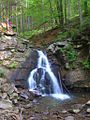 Biała Wisełka
 -
 Lake Morskie Oko, White Dunajec Springs
 -
 Vistula flooding south of Warsaw, 2004
 -
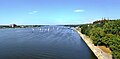 Vistula in Płock


The Vistula is navigable from the Baltic Sea to Bydgoszcz (where the Bydgoszcz Canal joins the river). The Vistula can accommodate modest river vessels of CEMT class II. Farther upstream the river depth lessens. Although a project was undertaken to increase the traffic-carrying capacity of the river upstream of Warsaw by building a number of locks in and around Kraków, this project was not extended further, so that navigability of the Vistula remains limited. The potential of the river would increase considerably if a restoration of the East-West connection via the Narew–Bug–Mukhovets–Pripyat–Dnieper waterways were considered. The shifting economic importance of parts of Europe may make this option more likely.
Etymology
The name was first recorded by Pliny in a.d. 77 in his Natural History. He uses Vistula (4.52, 4.89) with a masculine variant Vistillus (3.06). The root of the name Vistula is Indo-European *u̯eis- ‘to ooze, flow slowly’ (cf. Sanskrit aveṣan ‘they flowed’, Old Norse veisa ‘slime’) and is found in many European rivernames (e.g. Weser, Viesinta).[11] The diminutive endings -ila, -ula, were used in many Indo-European languages, including Latin (see Ursula).
In writing about the Vistula River and its peoples, Ptolemy uses the Greek spelling Ouistoula. Other ancient sources spell it Istula. Pomponius Mela refers to the Visula (De chorographia libri tres, Book 3; a.d. 44) and Ammianus Marcellinus to the Bisula (Book 22), both of which names lack the -t-. Jordanes (Getica 5 & 17) uses Viscla while the Anglo-Saxon poem Widsith refers to it as the Wistla.[12] 12th-century Polish chronicler Wincenty Kadłubek Latinised the rivername as Vandalus, a form presumably influenced by Lithuanian vanduõ ‘water’, while Jan Długosz in his Annales seu cronicae incliti regni Poloniae called the Vistula ‘white waters’ (Alba aqua), perhaps referring to the White Little Vistula (Biała Wisełka): “a nationibus orientalibus Polonis vicinis, ob aquae candorem Alba aqua ... nominatur.”
During the Roman period, the Baltic was called the Mare Suebicum, after the Germanic Suebi people, who apparently originated from the region of the Oder. The name is believed to come from Proto-Germanic *swēbaz, either based on the Proto-Germanic root *swē- meaning "one's own" people, the third person reflexive pronoun.[13] from an Indo-European root *swe-,[14]
Historical relevance
Ancient settlements

Large parts of the Vistula Basin were occupied by the Iron Age Lusatian and Przeworsk cultures in the first millennium BC. Genetic analysis indicates that there has been an unbroken genetic continuity[clarification needed] of the inhabitants over the last 3,500 years.[15] The Vistula Basin along with the lands of the Rhine, Danube, Elbe, and Oder came to be called Magna Germania by Roman authors of the 1st century AD.[15] This doesn't imply that the inhabitants were "Germanic" in the modern sense of the term; Tacitus, when describing the Venethi, Peucini and Fenni, wrote that he was not sure if he should call them Germans, since they had settlements and they fought on foot, or rather Sarmatians since they have some similar customs to them.[16] Ptolemy, in the 2nd century AD, would describe the Vistula as the border between Germania and Sarmatia.

The Vistula river used to be connected to the Dnieper River, and thence to the Black Sea via the Augustów Canal, a technological marvel with numerous sluices contributing to its aesthetic appeal. It was the first waterway in Central Europe to provide a direct link between the two major rivers, the Vistula and the Neman. It provided a link with the Black Sea to the south through the Oginski Canal, Dnieper River, Berezina Canal, and Dvina River. The Baltic Sea–Vistula–Dnieper–Black Sea route with its rivers was one of the most ancient trade routes, the Amber Road, on which amber and other items were traded from Northern Europe to Greece, Asia, Egypt, and elsewhere.[17][18]

The Vistula estuary was settled by Slavs in the 7th and 8th century.[19] Based on archeological and linguistic findings, it has been postulated that these settlers moved northward along the Vistula river.[19] This however contradicts another hypothesis supported by some researchers saying the Veleti moved westward from the Vistula delta.[19]
A number of West Slavic Polish tribes formed small dominions beginning in the 8th century, some of which coalesced later into larger ones. Among the tribes listed in the Bavarian Geographer's 9th century document were the Vistulans (Wiślanie) in southern Poland. Kraków and Wiślica were their main centres.
Many Polish legends are connected with the Vistula and the beginnings of Polish statehood. One of the most enduring is that about princess Wanda co nie chciała Niemca (who rejected the German).[20] According to the most popular variant, popularized by the 15th century historian Jan Długosz,[21] Wanda, daughter of King Krak, became queen of the Poles upon her father's death.[20] She refused to marry a German prince Rytigier (Rüdiger), who took offence and invaded Poland, but was repelled.[22] Wanda however committed suicide, drowning in the Vistula river, to ensure he would not invade her country again.[22]
Main trading artery

For hundreds of years the river was one of the main trading arteries of Poland, and the castles that line its banks were highly prized possessions. Salt, timber, grain, and building stone were among goods shipped via that route between the 10th and 13th centuries.[23]

In the 14th century the lower Vistula was controlled by the Teutonic Order, invited in 1226 by Konrad I of Masovia to help him fight the pagan Prussians on the border of his lands. In 1308 the Teutonic Knights captured the Gdańsk castle and murdered the population.[24] Since then the event is known as the Gdańsk slaughter. The Order had inherited Gniew from Sambor II, thus gaining a foothold on the left bank of the Vistula.[25] Many granaries and storehouses, built in the 14th century, line the banks of the Vistula.[26] In the 15th century the city of Gdańsk gained great importance in the Baltic area as a centre of merchants and trade and as a port city. While at this time the surrounding lands were inhabited by Pomeranians, Gdańsk soon became a starting point for German settlement of the largely fallow Vistulan country.[27]
Before its peak in 1618, trade increased by a factor of 20 from 1491. The tonnage of grain traded on the river in key years is telling: 1491: 14,000; 1537: 23,000; 1563: 150,000; 1618: 310,000.[28]

In the 16th century most of the grain exported was leaving Poland through Gdańsk, which because of its location at the terminal point of the Vistula and its tributaries waterway and of its Baltic seaport trade role became the wealthiest, most highly developed (by far the largest center of crafts and manufacturing) and most autonomous of the Polish cities.[30] Other towns were negatively affected by Gdańsk's near-monopoly in foreign trade. During the reign of Stephen Báthory Poland ruled two main Baltic Sea ports: Gdańsk[31] controlling the Vistula river trade and Riga controlling the Western Dvina trade. Both cities were among the largest in the country. Around 70% the exports from Gdańsk were of grain.[28]
Grain was also the largest export commodity of the Polish–Lithuanian Commonwealth. The volume of traded grain can be considered a good and well-measured proxy for the economic growth of the Commonwealth.

The owner of a folwark usually signed a contract with the merchants of Gdańsk, who controlled 80% of this inland trade, to ship the grain north to that seaport on the Baltic Sea. Many rivers in the Commonwealth were used for shipping purposes, including the Vistula. The river had a relatively well-developed infrastructure, with river ports and granaries. Most river shipping travelled north, southward transport being less profitable, and barges and rafts were often sold off in Gdańsk for lumber.
In order to arrest recurrent flooding on the lower Vistula, the Prussian government in 1889-95 constructed an artificial channel about 12 kilometres (7 miles) east of Gdańsk (German name: Danzig)—known as the Vistula Cut (German: Weichseldurchstich; Polish: Przekop Wisły)—that acted as a huge sluice, diverting much of the Vistula flow directly into the Baltic. As a result, the historic Vistula channel through Gdańsk lost much of its flow, and was known thereafter as the Dead Vistula (German: Tote Weichsel; Polish: Martwa Wisła). German states got complete control of the region in 1795-1812 (see: Partitions of Poland), as well as during the World Wars, in 1914-1918 and 1939-1945.

From 1867 to 1917, the Russian tsarist administration called the Kingdom of Poland the Vistula Land after the collapse of the January Uprising (1863–1865).[32]
Almost 75% of the territory of interbellum Poland was drained northward into the Baltic Sea by the Vistula (total area of drainage basin of the Vistula within boundaries of the Second Polish Republic was 180,300 km²), the Niemen (51,600 km²), the Odra (46,700 km²) and the Daugava (10,400 km²).
.jpg)
In 1920 the decisive battle of the Polish–Soviet War Battle of Warsaw (sometimes referred to as the Miracle at the Vistula), was fought as Red Army forces commanded by Mikhail Tukhachevsky approached the Polish capital of Warsaw and nearby Modlin Fortress situated on the mouth of the Vistula.[34]
World War II
The Polish September campaign included battles over control of the mouth of the Vistula, and of the city of Gdańsk, so close to the river delta. During the Invasion of Poland (1939), after the initial battles in Pomerelia, the remains of the Polish Army of Pomerania withdrew to the southern bank of the Vistula.[35] After defending Toruń for several days, the army withdrew further south under pressure of the overall strained strategic situation, and took part in the main battle of Bzura.[35]
The Auschwitz complex of concentration camps was located on the Vistula, at the confluence of the Vistula and the Soła rivers.[36] Ashes of murdered Auschwitz victims were dumped into the river.[37]
During World War II prisoners of war from the Nazi Stalag XX-B camp were assigned to cut ice blocks from the River Vistula. The ice would then be transported by truck to the local beer houses.
The 1944 Warsaw Uprising was planned with the expectation that the Soviet forces, who had arrived in the course of their offensive and were waiting on the other side of the Vistula River in full force, would help in the battle for Warsaw.[38] However the Soviets let down the Poles, stopping their advance at the Vistula and branding the insurgents as criminals in radio broadcasts.[38][39][40]
In early 1945 the Red Army crossed the Vistula and drove the German Wehrmacht back past the Oder river in Germany in the Vistula–Oder Offensive.
See also
References
- ^ Barania Góra - Tam, gdzie biją źródła Wisły at PolskaNiezwykla.pl
- ^ Żaneta Kosińska: Rzeka Wisła.
- ^ Nazewnictwo geograficzne Polski. T.1: Hydronimy. 2cz. w 2 vol. ISBN 8323996075.
- ^ Wysota, W.; Molewski, P.; Sokołowski, R.J., Robert J. (2009). "Record of the Vistula ice lobe advances in the Late Weichselian glacial sequence in north-central Poland". Quaternary International. 207: 26. doi:10.1016/j.quaint.2008.12.015.
- ^ Template:En icon Zbigniew Pruszaka, Elżbieta Zawadzka. "Potential Implications of Sea-Level Rise for Poland". www.bioone.org. Retrieved 23 October 2009.
- ^ Template:En icon "Final International ASTRA conference in Espoo, Finland, 10–11 December 2007". www.astra-project.org. Retrieved 23 October 2009.
- ^ Template:En icon Matt McGrath (12 March 2009). "Climate scenarios 'being realised'". BBC News. Retrieved 23 October 2009.
- ^ Template:En icon "Hydrology and morphology of two river mouth regions (temperate Vistula Delta and subtropical Red River Delta)" (PDF). www.iopan.gda.pl. Retrieved 23 October 2009.
- ^ Państwowy Instytut Geologiczny (State Geological Institute), Warsaw, "Geologiczna historia Wisły"
- ^ R. Mierzejewski, Państwowa Wyższa Szkoła Filmowa, Telewizyjna i Teatralna im. Leona Schillera w Łodzi, Narodziny rzeki
- ^ D.Q. Adams, Encyclopedia of Indo-European Culture (London: Fitzroy-Dearborn, 1997), 207.
- ^ Template:En icon William Napier (20 November 2005). "Building a Library: The Fall of Rome". findarticles.com. Independent Newspapers UK Limited. Retrieved 1 April 2009. [dead link]
- ^ Peterson, Lena. "Swābaharjaz" (pdf). Lexikon över urnordiska personnamn. Institutet för språk och folkminnen, Sweden. pp. page 16. Retrieved 11 October 2007.
{{cite web}}:|pages=has extra text (help) (Text in Swedish); for an alternative meaning, as "free, independent" see Room, Adrian (2006). "Placenames of the World: Origins and Meanings of the Names for 6,600 Countries, Cities, Territories, Natural Features and Historic Sites: Second Edition". Jefferson, North Carolina, and London: McFarland & Company, Inc., Publishers: 363, 364. ISBN 0786422483.{{cite journal}}:|contribution=ignored (help); Cite journal requires|journal=(help); compare Suiones. - ^ Pokorny, Julius. "Root/Lemma se-". Indogermanisches Etymologisches Wörterbuch. Indo-European Etymological Dictionary (IEED), Department of Comparative Indo-European Linguistics, Leiden University. pp. pages 882–884.
{{cite web}}:|pages=has extra text (help) (German language text); locate by searching the page number.Köbler, Gerhard (2000). "*se-" (pdf). Indogermanisches Wörterbuch: 3. Auflage. pp. page 188.{{cite web}}:|pages=has extra text (help) (German language text); the etymology in English is in Watkins, Calvert (2000). "s(w)e-". The American Heritage Dictionary of the English Language: Fourth Edition.{{cite web}}:|chapter=ignored (help) Some related English words are sibling, sister, swain, self. - ^ a b Template:Pl icon Jędrzej Giertych. "Tysiąc lat historii narodu polskiego". www.chipublib.org. Retrieved 3 April 2009.
- ^ De Origine et Situ Germanorum by Cornelius Tacitus
- ^ Augustów Canal on UNESCO Tentative List of Cultural Properties
- ^ The Augustów Canal at www.suwalszczyzna.pl
- ^ a b c Template:De icon Jan M. Piskorski (1999). Pommern im Wandel der Zeit. ISBN 8-3906-184-8-6.
{{cite book}}: Cite has empty unknown parameter:|chapterurl=(help) p.29 - ^ a b Template:En icon Paul Havers. "The Legend of Wanda". www.kresy.co.uk. Retrieved 31 March 2009.
- ^ Template:En icon Leszek Paweł Słupecki. "The Krakus' and Wanda's Burial Mounds of Cracow" (PDF). sms.zrc-sazu.si. Retrieved 31 March 2009. p.84
- ^ a b Template:En icon "Wanda". www.brooklynmuseum.org. Retrieved 31 March 2009.
- ^ Template:En icon Władysław Parczewski, Jerzy Pruchnicki. "Vistula River". Encyclopedia Britannica. Retrieved 3 April 2009.
- ^ Template:En icon "History of the City Gdańsk". www.en.gdansk.gda.pl. Retrieved 3 April 2009.
- ^ Template:En icon Rosamond McKitterick, Timothy Reuter, David Abulafia, C. T. Allmand (1995). Vol.5 (ed.). The New Cambridge Medieval History: C. 1198-C. 1300. Cambridge University Press. ISBN 0-521-36289-X.
{{cite book}}: Cite has empty unknown parameter:|chapterurl=(help)CS1 maint: multiple names: authors list (link) CS1 maint: numeric names: editors list (link) - ^ Template:Pl icon Krzysztof Mikulski. "Dzieje dawnego Torunia". www.mowiawieki.pl. Retrieved 3 April 2009.
- ^ Template:De icon Oskar Halecki, Antony Polonsky (1978). A history of Poland. Routledge. ISBN 0-7100-8647-4.
{{cite book}}: Cite has empty unknown parameter:|chapterurl=(help) p.35 - ^ a b Template:En icon Krzysztof Olszewski (2007). The Rise and Decline of the Polish-Lithuanian Commonwealth due to Grain Trade.
{{cite book}}:|access-date=requires|url=(help); Cite has empty unknown parameter:|chapterurl=(help) a: p. 6, b: p. 7, c: p. 5, d: p. 5 - ^ Template:Pl icon Jerzy S. Majewski (29 April 2004). "Most Zygmunta Augusta". miasta.gazeta.pl. Retrieved 25 October 2009.
- ^ Template:En icon "Gdańsk (Poland)". Encyclopedia Britannica. Retrieved 3 April 2009.
- ^ Template:En icon "Stephen Bathory (king of Poland)". Encyclopedia Britannica. Retrieved 3 April 2009.
- ^ The name of the kingdom was changed to Privislinsky Krai, which was reduced to a tsarist province; it lost all autonomy and separate administrative institutions. Template:En icon Richard C. Frucht (2008). Eastern Europe: An Introduction to the People, Lands, and Culture. ABC-CLIO. ISBN 1-57607-800-0.
{{cite book}}: Cite has empty unknown parameter:|chapterurl=(help) p. 19 - ^ Template:En icon "SEPTEMBER 13, 1944". www.1944.pl. Retrieved 25 October 2009. [dead link]
- ^ Template:En icon "Vistula River Victory". www.electronicmuseum.ca. Retrieved 3 April 2009. [dead link]
- ^ a b Template:En icon Marek Jan Chodakiewicz (1978). Between Nazis and Soviets: Occupation Politics in Poland, 1939–1947. Lexington Books. ISBN 0-7391-0484-5.
- ^ US Holocaust Memorial Museum, Holocaust Encyclopedia, Auschwitz Environs, Summer 1944, online map
- ^ Auschwitz-Birkenau: History & Overview Jewish Virtual Library
- ^ a b Template:En icon "Warsaw Uprising of 1944". www.warsawuprising.com. Retrieved 14 July 2008.
- ^ The Uprising remained the ultimate symbol of Communist betrayal and bad faith for Poles. Template:En icon John Radzilowski. "Warsaw Uprising". ww2db.com. Retrieved 25 March 2010.
- ^ The Warsaw Rising was termed a “criminal organization” Template:En icon Radzilowski, John (2009). "Remembrance and Recovery: The Museum of the Warsaw Rising and the Memory of World War II in Post-communist Poland". The Public Historian. 31 (4): 143–158. doi:10.1525/tph.2009.31.4.143.
External links
Tributaries of the Vistula River | ||
|---|---|---|
| Forming rivers |
|  |
| Main tributaries of the left bank | ||
| Main tributaries of the right bank |
| |
| Distributary |
| |