
Wikipedia:WikiProject Highways/Assessment/A-Class Review/2009
| This page is an archive. Do not edit the contents of this page. Please direct any additional comments to the current main page. |
- The following is an archived roads debate. Please do not modify it. Subsequent comments should be made in a new section on the talk page, on WT:USRD, or another applicable discussion page. No further edits should be made to this section.
The result of the debate was Support. --Rschen7754 (T C) 23:57, 10 January 2009 (UTC)
Capitol Loop (Lansing, Michigan)
Capitol Loop (Lansing, Michigan) (edit | talk | history | links | watch | logs) review
- Suggestion: Promote to A-Class
- Nominator's comments: A truly unique trunkline. It has a name, not a number. It's hidden number makes it a "capitol loop" of the Interstate system, and it has a unique marker. I think this article has FA potential, but I'd like some feedback first.
- Nominated by: Imzadi1979 (talk) 20:14, 27 October 2008 (UTC)
- First comment occurred: 18:45, 2 November 2008 (UTC)
- Comment - An image of the road would be nice
and can we have an SVG version of the shield?~~ ComputerGuy 18:45, 2 November 2008 (UTC)
Comments
- Wikilink first mention of R.E. Olds, Martin Luther King, Jr. (maybe, 1st mention in history is linked, but not rd), will finish later. have to go.Dave (talk) 05:40, 6 November 2008 (UTC)
- The last paragraph has a lot of dates, I'm not sure if the 1.08 million is a modern figure or 1928 dollars. Might want to clarify.
Finished, sorry that took so long. Dave (talk) 19:49, 9 November 2008 (UTC)
- I added in inflation-adjusted numbers. Since the contract would have been bid and let in 2004, all costs given are used in 2004 dollars. As for wikilinking the names, I'm not sure if this is correct, since the only MLK references I can find in the RD are contained in the name of a road. In otherwords, it seems wrong to have "Martin Luther King, Jr. Boulevard" since the name there refers directly to a street, not a person in that context. The same goes for the "R.E. Olds Transportation Museum". I'm not sure if I'm off the mark on this one. Imzadi1979 (talk) 21:05, 9 November 2008 (UTC)
Support issues resolved. Dave (talk) 02:35, 10 November 2008 (UTC)
Comments Last sentence of lead - watch WP:MOSDASH.
"street is divided into three-lane north and south bound sections" - rephrase.three-lane Grand Avenue - three lanes each direction?four-lane street - see aboveEast of the river comma3rd paragraph RD - combine last two sentencesCedar street - capitalizeafter that - Westbound should not be capitalized1.1 - comma after (AADT)Lost a period after 730 commercial vehicles.Alleghan and Ottawa streets commaused those streets commaLast sentence - comma after thereHistory - 2.2 - floated... around?Weren't - spell outThe city wanted to start a scaled down version of the project in 2004 however. - move however to the front of the sentenceGoogle Streetview could be considered a primary source by FAC, and a lot of the RD is based off it. FAC might complain. Just a warning.Lost a period after "The project was finished three months early and opened to traffic at a ribbon-cutting ceremony in Lansing on June 30, 2005"- Overall, a pretty good article. --Rschen7754 (T C) 04:15, 28 November 2008 (UTC)
- Thanks, I made some copy edits. Let me know if they help or not. Imzadi1979 (talk) 02:34, 1 December 2008 (UTC)
- Support issues resolved. --Rschen7754 (T C) 07:16, 1 December 2008 (UTC)
- Thanks, I made some copy edits. Let me know if they help or not. Imzadi1979 (talk) 02:34, 1 December 2008 (UTC)
- Support - A pretty well-written article. - Algorerhythms (talk) 19:50, 24 December 2008 (UTC)
- The above is an archived roads debate. Please do not modify it. Subsequent comments should be made in a new section on the talk page, on WT:USRD, or another applicable discussion page. No further edits should be made to this section.
- The following discussion is preserved as an archive. Please do not modify it. Subsequent comments should be made on the appropriate discussion page. No further edits should be made to this discussion.
Support. --Rschen7754 (T C) 22:49, 30 January 2009 (UTC)
New York State Route 292
New York State Route 292 (edit | talk | history | links | watch | logs) review
- Suggestion: Promote to A-Class
- Nominator's comments:
- Nominated by: –Juliancolton Tropical Cyclone 18:13, 10 December 2008 (UTC)
- First comment occurred: 07:25, 21 December 2008 (UTC)
Comments'
- I don't understand this phrase, please reword for those of us who aren't from the east coast =-) "Patterson hamlet of the same name."
- Any information to show notability of this route? I.E, any notable geographical features? any historical events on this route? The article is pretty in depth about the renumbering and historical route changes, but could use some other types of information also. Specifically I'd suggest a little history search. This route was notable enough to have existed since the 1920s so it must have been an important trade route or something. Dave (talk) 07:25, 21 December 2008 (UTC)
 Done. Thanks for the review. –Juliancolton Happy Holidays 14:22, 21 December 2008 (UTC)
- Sorry it took me a while to get back to this. I agree you've fixed my second point. I'm still confused by the statement "Patterson hamlet of the same name" same name as what? a town? Dave (talk) 06:53, 4 January 2009 (UTC) (sorry for the late response). –Juliancolton Tropical Cyclone 03:00, 11 January 2009 (UTC)
Support Comments resolved. Dave (talk) 04:10, 22 January 2009 (UTC) Comments
- This is probably a short enough article to generate some opposes from FAC. Just a warning.
- Yeah, I know about that all too well. I wasn't planning on nominating this. –Juliancolton Happy Holidays 01:56, 25 December 2008 (UTC)
- First paragraph RD - you use forms of "passing" a lot.
- History - currency should provide a modern equivalent due to inflation.
- Done with those two. –Juliancolton Happy Holidays 01:56, 25 December 2008 (UTC)
- Are you supposed to use something like {{cquote}} for the quote? I could be wrong on this one.
- Per MoS, short quotes of only a couple sentences should remain within the text. –Juliancolton Happy Holidays 01:56, 25 December 2008 (UTC)
- Otherwise a pretty good article. --Rschen7754 (T C) 01:46, 25 December 2008 (UTC)
- Thanks for the review, –Juliancolton Happy Holidays 01:56, 25 December 2008 (UTC)
Support comments addressed. --Rschen7754 (T C) 02:01, 25 December 2008 (UTC)
- Conditional support... only problem I saw was 1.61 miles (2.59 km) dirt road. Assuming this is a {{convert}} artifact, you can use
sing=onto fix this. Fix this and you can consider me a support!—Scott5114↗ [EXACT CHANGE ONLY] 05:58, 29 January 2009 (UTC)
 Fixed. Thanks, –Juliancolton Tropical Cyclone 14:59, 29 January 2009 (UTC)
- The above discussion is preserved as an archive. Please do not modify it. Subsequent comments should be made on the appropriate discussion page, such as the current discussion page. No further edits should be made to this discussion.
- The following discussion is preserved as an archive. Please do not modify it. Subsequent comments should be made on the appropriate discussion page. No further edits should be made to this discussion.
Result of the discussion was promote to A-class. --Polaron | Talk 17:42, 25 March 2009 (UTC)
California State Route 78
California State Route 78 (edit | talk | history | links | watch | logs) review
- Suggestion: No suggestion given regarding A-Class
- Nominator's comments: This article recently passed GA, but I think there's enough info to possibly send it onward.
- Nominated by: --Rschen7754 (T C) 01:59, 27 October 2008 (UTC)
- First comment occurred: 02:20, 27 October 2008 (UTC)
- Comment —
source the entire RD, preferably at the end of each paragraph. –Juliancolton Tropical Cyclone 02:20, 27 October 2008 (UTC)- It's basically the same sources over and over again... --Rschen7754 (T C) 02:26, 27 October 2008 (UTC)
- True, but at least one source per paragraph to verify the content is usually required. –Juliancolton Tropical Cyclone 01:59, 28 October 2008 (UTC)
- Done --Rschen7754 (T C) 02:05, 28 October 2008 (UTC)
- Looks good; I'll try to review the article in full soon. –Juliancolton Tropical Cyclone 02:09, 28 October 2008 (UTC)
- True, but at least one source per paragraph to verify the content is usually required. –Juliancolton Tropical Cyclone 01:59, 28 October 2008 (UTC)
- It's basically the same sources over and over again... --Rschen7754 (T C) 02:26, 27 October 2008 (UTC)
- Comment - An image of the road itself would be nice. ~~ ComputerGuy 18:43, 2 November 2008 (UTC)
- Eh, maybe I could get one this weekend. Thanks for the reminder. --Rschen7754 (T C) 19:16, 2 November 2008 (UTC)
- Done. Not a very good one; my camera ran out of batteries and I had to use my laptop camera. Maybe next time it'll be better... --Rschen7754 (T C) 09:37, 3 November 2008 (UTC)
- Eh, maybe I could get one this weekend. Thanks for the reminder. --Rschen7754 (T C) 19:16, 2 November 2008 (UTC)
- Comment
This is a good article but does cross one of my pet-peeves with many USRD articles, red links that are unnecessary. I would advise to search the important terms for all red linked articles to see if the article exists, but under a different title, for example, Chocolate Mountain Aerial Gunnery Range does exist, as does Chocolate Mountains and Battle of San Pasqual. With some minor changes to text, a lot of these red links could be turned blue or eliminated. I doubt some of the creeks are notable enough for articles and could be potentially de-linked. Also the italicized 86 in the Major intersections is never explained.Dave (talk) 05:10, 6 November 2008 (UTC)
- I believe I fixed the issues... it look good? --Rschen7754 (T C) 05:50, 6 November 2008 (UTC)
- Yeah Support. I did find a couple of nit pick items, but not enough to merit an oppose. Source 5- This should be downcased, per MOS:CAPS under the All Caps section. Also some people at FAC have a real issue with "wordy words" like Although. you might want to go through and cut some of those out.Dave (talk) 04:58, 4 February 2009 (UTC)
- Just a quick note, the word "although" is generally allowed. It's the words that imply a POV which are discouraged. –Juliancolton Tropical Cyclone 20:00, 9 November 2008 (UTC)
- Yeah Support. I did find a couple of nit pick items, but not enough to merit an oppose. Source 5- This should be downcased, per MOS:CAPS under the All Caps section. Also some people at FAC have a real issue with "wordy words" like Although. you might want to go through and cut some of those out.Dave (talk) 04:58, 4 February 2009 (UTC)
- I believe I fixed the issues... it look good? --Rschen7754 (T C) 05:50, 6 November 2008 (UTC)
What is the status of this review? I have addressed the major objections... --Rschen7754 (T C) 20:07, 22 December 2008 (UTC)
- Support with minor nitpick - Overall, it's a good article. I just have one minor nitpick: in the lead: "The route travels through the heavily populated cities of northern San Diego County before turning into a highway running through the mountains to Julian." It isn't a highway in the cities of San Diego County? This sentence may need to be reworded to make it a bit clearer. - Algorerhythms (talk) 19:45, 24 December 2008 (UTC)
- Clarified. --Rschen7754 (T C) 19:56, 24 December 2008 (UTC)
If anybody's wondering why this is still here - this is just in case the ACR fails. --Rschen7754 (T C) 05:46, 26 January 2009 (UTC)
- Support - This article is too good to be a good article. – CG 01:47, 5 February 2009 (UTC)
- Apparently not, because it failed two FACs. --Rschen7754 (T C) 01:52, 5 February 2009 (UTC)
- Maybe it could mean that it is too good to be a good article but not good enough to be a featured article? -- M*gill*FR (blab to me) 01:58, 5 February 2009 (UTC)
- I guess. CG: We don't like '''Support''' Good job! ~~~~ because it doesn't reflect that you even read the article. --Rschen7754 (T C) 02:17, 5 February 2009 (UTC)
- Maybe it could mean that it is too good to be a good article but not good enough to be a featured article? -- M*gill*FR (blab to me) 01:58, 5 February 2009 (UTC)
- Apparently not, because it failed two FACs. --Rschen7754 (T C) 01:52, 5 February 2009 (UTC)
- Comments I just spent the last hour or so reading this, so here are my thoughts (mostly in order of appearance).
- The infobox map could use either shields or a statewide locator inset so that the average person can determine where SR 78 is in relation to other points of reference. Also, the county/state lines on the map aren't at MTF standards (I had to look hard and read the RD before realizing a line was actually the AZ border). I won't let the map issue get in the way of my support of this article, but it would be good to see these things corrected.
- I don't think I can take care of this. --Rschen7754 (T C) 08:57, 5 March 2009 (UTC)
- Use of term "commissioned" twice in the second paragraph of the lead. I'm not sure on the status of this word being a neologism when used in the highway sense, but it might be better to replace it with something else ("constructed", "designated", etc.) if this article is to go any higher.
- Done. --Rschen7754 (T C) 21:05, 19 February 2009 (UTC)
- To me, talking about the legislative definitions at the beginning of the route description, especially when the route has yet to be fully described, seems backward. I realize this is a CASH standard, but it still seems awkward when reading.
- See below. --Rschen7754 (T C) 08:57, 5 March 2009 (UTC)
- Link "County Route S3" here.
- Done. --Rschen7754 (T C) 21:31, 19 February 2009 (UTC)
- The part about the Juan Bautista de Anza Nat'l Historic Trail in the first paragraph of the RD may be better presented where it occurs in the route, as opposed to the separate mention here.
- I think that it is better with the rest of the designations. In regards to the legislative definitions, it's a new thing we're trying at CASH and hasn't been implemented in most of the articles. --Rschen7754 (T C) 08:57, 5 March 2009 (UTC)
- Second mention of the "Anza Borrego Desert State Park" needs a hyphen.
- Done, and unlinked second mention. --Rschen7754 (T C) 21:31, 19 February 2009 (UTC)
- SR 78 is a freeway from its western terminus in Oceanside to its junction with Broadway in Escondido. It begins at a nonstandard interchange with I-5 and Vista Way, which involves a traffic signal.[10] SR 78 then travels east through Oceanside, loosely paralleling Buena Vista Creek before entering Vista. This could be rewritten to sound less weird. "SR 78 begins in Oceanside as a continuation of Vista Way. As it crosses over I-5, the route becomes a freeway as it travels east through Oceanside. The freeway loosely parallels Buena Vista Creek before entering Vista." Also, is there an article on the creek that can be linked?
- Done. As far as the link to the creek (which has no article), I had to remove that link earlier in this ACR. --Rschen7754 (T C) 19:52, 22 February 2009 (UTC)
- After that, the freeway abruptly ends at the intersection with Broadway, after the Centre City Parkway interchange (I-15 Business). Rearrange to avoid use of "after" twice. "After passing the Center City Parkway (I-15 Business) interchange, the freeway abruptly ends at the intersection with Broadway."
- Done. --Rschen7754 (T C) 19:52, 22 February 2009 (UTC)
- General comment: Use of directional terms (left, right) with compass terms (north, east, etc.) parenthetically should be avoided. I would stick to using compass terms, to better relate in prose the directions the route takes. Make sure this is corrected in all instances.
- Done. --Rschen7754 (T C) 04:57, 1 March 2009 (UTC)
- SR 78 becomes a serpentine road... "Serpentine road" is a bit unusual. "follows a serpentine alignment" perhaps?
- Done. --Rschen7754 (T C) 04:57, 1 March 2009 (UTC)
- SR 78 then leaves Ramona as Julian Road, which continues on a winding mountain road through Witch Creek... try "alignment" instead of "road", since Julian "Road" appears already.
- Done. --Rschen7754 (T C) 04:57, 1 March 2009 (UTC)
- SR 78 and 79 run concurrently across the headwater... "SR 78 and 79" doesn't read well. Try "the highway runs concurrently with SR 79..." There are 2 instances of this. Also, "headwater" needs an "s".
- Done. Rschen7754 (T C) 04:57, 1 March 2009 (UTC)
- ...SR 78 heads northeast as winding Banner Road through Whispering Pines. Rearrange as "...SR 78 heads northeast as Banner Road, winding through Whispering Pines."
- Done. --Rschen7754 (T C) 04:57, 1 March 2009 (UTC)
- SR 78 intersects with County Route S2 (CR S2) in what is known as Scissors Crossing, referring to the shape of the interchange as CR S2 runs concurrently in a wrong-way multiplex. This sentence confuses me. It needs parentheses and/or clarification to make the intended meaning clear.
- Done. --Rschen7754 (T C) 04:57, 1 March 2009 (UTC)
- "Anza Borrego Desert State Park" should have a hyphen to avoid a redirect.
- Cannot find it in the route description. I may have removed the link.
- SR 78 and 86 Again, revise this (2 occurrances) to read more clearly.
- Done. --Rschen7754 (T C) 04:57, 1 March 2009 (UTC)
- BIG NITPICK: In the entire route description, I only found one sentence that did not use the term "SR 78". Using the two-letter abbreviation all the time is very repetitive and, when considering other highways mentioned in the prose, gives the text a blocky look that gets difficult to read after a while. Other terms to consider using in the prose when talking specifically about SR 78: "State Route 78", "Route 78", "the road", "the highway", "the freeway", "the route", "it", etc. With other intersecting/overlapping routes, it may be helpful to use the full name of the other route at its first appearance (i.e. "State Route 86") and then use an abbreviation ("SR 86") on subsequent uses, again to avoid the overuse of "SR" and "CR" throughout. I feel this is a major prose issue that should have been addressed previously and must be corrected before the article is promoted to A-class.
- Changed some instances described above. --Rschen7754 (T C) 04:57, 1 March 2009 (UTC)
- Before the designation of SR 78, a road known as ... and Brawley around 1900. Need to insert "existed" before "around" ,or replace "around" with "by".
- Modified. --Rschen7754 (T C) 08:57, 5 March 2009 (UTC)
- Dab "U.S. Route 395" to the CA article.
- Done. --Rschen7754 (T C) 08:57, 5 March 2009 (UTC)
- SR 78 turned south on Ash and rejoined the current alignment of the highway. "Ash" needs a street suffix.
- Done. --Rschen7754 (T C) 08:57, 5 March 2009 (UTC)
- The Vista Way Freeway opened in April 1962 between Interstate 5 and Melrose Drive, but was not entirely grade-separated. Was it called "Vista Way Freeway" at that time? Seems like "Vista Way Expressway" may have been its name, as alluded to earlier.
- It was Vista Way Freeway. --Rschen7754 (T C) 08:57, 5 March 2009 (UTC)
- (about $27 million today) Use "about $27 million in 2008 dollars" (or whatever year is appropriate).
- Addressed. --Rschen7754 (T C) 08:57, 5 March 2009 (UTC)
- Before the interchange was constructed, the intersection between SR 78 and College Boulevard was at-grade. This helped to improve traffic flow for students going to the college. It is logical to assume the interchange was previously an intersection. Combine this to avoid stating it obviously. "The interchange, previously an at-grade intersection, improved traffic flow to the college."
- Done. --Rschen7754 (T C) 08:57, 5 March 2009 (UTC)
- ...of building it through sand dunes. [25]Following this... Fix spacing of citation and adjacent sentences.
- Done. --Rschen7754 (T C) 08:57, 5 March 2009 (UTC)
- Delink "Jacob Dekema", unless he is particularly notable for some reason.
- Done. (He was responsible for building a lot of San Diego freeways and has I-805 named after him, but I can't source it or write an article.) --Rschen7754 (T C) 08:57, 5 March 2009 (UTC)
- ...the bypass does not exist today. [29] Finally... Fix spacing of citation and adjacent sentences.
- Done. --Rschen7754 (T C) 08:57, 5 March 2009 (UTC)
- The paragraph about the standoff really doesn't seem notable, other than it took place on SR 78. Since it doesn't add that much to the article, I would suggest its removal.
- Done. --Rschen7754 (T C) 08:57, 5 March 2009 (UTC)
- however, it has since been replaced by a park and ride. Reword for clarity: "however, it was removed to construct a park and ride lot."
- Done. --Rschen7754 (T C) 08:57, 5 March 2009 (UTC)
- After it rains during the desert monsoon season, these washes can be left with several inches of water, sand, and rock debris. Rearrange for flow: "During the monsoon season, these washes...inches of water, sand and rock debris following rainstorms."
- Done. --Rschen7754 (T C) 08:57, 5 March 2009 (UTC)
- The article could use more pictures, but I won't oppose its promotion due to a lack of photos.
- On the bucket list. --Rschen7754 (T C) 08:57, 5 March 2009 (UTC)
- The infobox map could use either shields or a statewide locator inset so that the average person can determine where SR 78 is in relation to other points of reference. Also, the county/state lines on the map aren't at MTF standards (I had to look hard and read the RD before realizing a line was actually the AZ border). I won't let the map issue get in the way of my support of this article, but it would be good to see these things corrected.
- Overall, I think the article is pretty good. It needs prose cleanup as outlined above, especially regarding the "SR 78" repetition issue. I would support promoting the article once these concerns are resolved. --LJ (talk) 02:49, 5 February 2009 (UTC)
- Issues addressed. --Rschen7754 (T C) 08:57, 5 March 2009 (UTC)
- On first look, all my issues/comments appear to have been addressed--except for some instances of the "left (north)" issue found in the last RD paragraph. I will probably support the article's promotion, but I would like to look at it one more time after the issues below are addressed. --LJ (talk) 00:53, 12 March 2009 (UTC)
- Fixed last paragraph. --Rschen7754 (T C) 01:46, 12 March 2009 (UTC)
- Comment A lot of good information in the article about an intersting route. A few fixes IMHO like these may help.
- Remove comma after and... road, and the portion from Julian to U.S. Route 99
- In this instance, the commas set off an appositive. --Rschen7754 (T C) 22:39, 13 March 2009 (UTC)
- Remove the word a in this segment....following a realignment since 1964
- Done. --Rschen7754 (T C) 21:53, 13 March 2009 (UTC)
- the first instance of U.S. say United States (U.S.)
- I assume you mean in the lead - corrected that one. --Rschen7754 (T C) 21:53, 13 March 2009 (UTC)
- What are Oceansie, Blythe, Brawley, Escondido and Julian are they all cities? I see Brawley is stated in the lead to be a town.
- Clarified in various places. --Rschen7754 (T C) 21:53, 13 March 2009 (UTC)
- Is the word however needed in this sentence...However, it was not commissioned east of
- Yes, as it shows a contrasting statement. --Rschen7754 (T C) 22:39, 13 March 2009 (UTC)
- How come SR is given as the abbrev in the lead, and then SR is used in the article all the way through correctly, however Interstate ## I-## is given as the abbreviation in the lead, and used in the lead as such, correctly...and then in the article Interstate is spelled out? or sometimes spelled out as Interstate 5 and in the same paragraph I-5...and sometimes in the article I and sometimes interstate.
- Corrected. --Rschen7754 (T C) 22:39, 13 March 2009 (UTC)
- Can the auto tour route not be after historic trail, as it sounds kind of redundant... Historic Trail auto tour route
- It is not, as the trail was not designed for automobiles. The roads do not follow the trail exactly. --Rschen7754 (T C) 22:39, 13 March 2009 (UTC)
- I will plunk this highway into a map soon, but is this right that a stretch of highway goes from the western junction to a western junction.... western junction of SR 79 to the western junction
- Yes - both SR 79 and SR 86 run concurrently with SR 78 at different points. --Rschen7754 (T C) 22:39, 13 March 2009 (UTC)
- What is a at a nonstandard interchange oh I see the which segment is at the end of the statement. Perhaps this could be re-worded to have the description of the interchange after the interchange itself is mentioned.
- I think I corrected it earlier in this ACR. --Rschen7754 (T C) 22:39, 13 March 2009 (UTC)
- Now it is more like an essay with this beginning....Those continuing on SR 78
- Reworded. --Rschen7754 (T C) 02:31, 22 March 2009 (UTC)
- There was just a segment where the road went through parks and forests...What is this place name..., town, city, park or forest...Banner Road through Whispering Pines.
- I don't understand.-Rschen7754 (T C) 02:31, 22 March 2009 (UTC)
- I wasn't sure what Whipering Pines was...town, park etc.
- Removed phrase; it appears that there is a Whispering Pines somewhere else in the state. --Rschen7754 (T C) 22:50, 22 March 2009 (UTC)
- I wasn't sure what Whipering Pines was...town, park etc.
- I don't understand.-Rschen7754 (T C) 02:31, 22 March 2009 (UTC)
- The County Route S3 (CR S3) defines the abbreviation....so does it need to be defined again...intersects with County Route S2 (CR S2)? There is not even an abbrev given later for town via County Route S3.
- Already addressed. --Rschen7754 (T C) 02:31, 22 March 2009 (UTC)
- Put the middle of the sentence reference after Brawley at the end of the sentence.SR 78 from Escondido to the east of Brawley,
- Repeat of above...mid sentence citation, and Interstate spelled out Interstate 5 and Melrose Drive'...Riverside county line into Blythe
- Fixed both of the above points. --Rschen7754 (T C) 02:31, 22 March 2009 (UTC)
- The first time currency is mentioned do $, and if you use the inflation conversion template the editors don't have to keep coming back year after year to re-do the inflation factor if the economy changes....$3.9 million (about $27 million today)...what year was the today in which this portion of the article was written? ...use the conversion template here as well....$800,941 at the time (about $4.97 million in 2007)...The U.S. dollar wikilink is only needed once.
- then-new..this does say the intent of the message, but I don't know if it is proper grammatically.
- Reworded. --Rschen7754 (T C) 03:56, 22 March 2009 (UTC)
- Should the future plans section incorporate the future road section template
- I don't think so, since the road is entirely constructed; these are relatively minor changes. --Rschen7754 (T C) 03:56, 22 March 2009 (UTC)
- R and N reflect mileage following a realignment since 1964; ... T for temporary, R for realignment what does N mean?...As there is an italicized blurb explaining the table, could the column labeled # also be explained?
- I fixed it. -- M*gill*FR (blab to me) 01:06, 7 March 2009 (UTC)
I would support promoting the article once these concerns are resolved. I didn't look at references yet but the GA probably did that. I'll double check the other GA, FA, A criteria later. Just read the interesting article this time through. SriMesh | talk 07:16, 10 February 2009 (UTC)
- I plan on addressing these comments later in the week. --Rschen7754 (T C) 07:32, 10 February 2009 (UTC)
Reviewing: I've begun reviewing this article, but I'm not finished as of yet. — master sonT - C 19:33, 12 February 2009 (UTC)
- Comments from Master son
- Infobox
- I would consider having "deleted" be renamed as "former". (Nothing to do with the article, but still...)
- The article is called "deleted". --Rschen7754 (T C) 04:16, 22 March 2009 (UTC)
- I would consider having "deleted" be renamed as "former". (Nothing to do with the article, but still...)
- Lead Section
- The route travels as a freeway through the heavily populated cities of northern San Diego County before turning into a highway running through the Santa Rosa Mountains to Julian. Following this, SR 78 enters Imperial County and travels through the desert near the Salton Sea before turning north to Blythe. I seem to have reservations about routes traveling. perhaps the following:
- The route is a freeway in the heavily populated cities of northern San Diego County and a ?-lane highway in the Santa Rosa Mountains and eastward to Julian. In Imperial County, SR 78 traverses the desert near the Salton Sea before turning north to Blythe.
- The ? is either 2 or 4 (I don't know which one it is). Highway is vague - of course its a highway;)
- Done. --Rschen7754 (T C) 04:16, 22 March 2009 (UTC)
- The route travels as a freeway through the heavily populated cities of northern San Diego County before turning into a highway running through the Santa Rosa Mountains to Julian. Following this, SR 78 enters Imperial County and travels through the desert near the Salton Sea before turning north to Blythe. I seem to have reservations about routes traveling. perhaps the following:
- Route Description
- SR 78 then travels east through Oceanside, loosely paralleling Buena Vista Creek before entering Vista Again, a road travels? (of course this might come back to bite me in the face;)) This occurs many times through the route description.
- I've seen worse; I'm not sure what to change it to if it needs to be out. --Rschen7754 (T C) 04:23, 22 March 2009 (UTC)
- SR 78 intersects with County Route S2 (CR S2) in what is known as Scissors Crossing, referring to the shape of the interchange as CR S2 runs concurrently in a wrong-way multiplex. Is Multiplex still considered a Neologism?
I don't think so after the second arbitration case; I don't like using that word in an article, but I didn't know how to mention the wrong-way portion of it.Fixed. --Rschen7754 (T C) 04:16, 22 March 2009 (UTC)
- SR 78 then travels east through Oceanside, loosely paralleling Buena Vista Creek before entering Vista Again, a road travels? (of course this might come back to bite me in the face;)) This occurs many times through the route description.
- History
- No road connected Brawley with Glamis along the route of SR 78; it was necessary to travel north through Calipatria to reach Blythe. Seems there's something important about the fact that no road connected the two cities along this route. Perhaps maybe mention that theres no direct route rather than mentioning the route number?
- Rephrased. --Rschen7754 (T C) 04:16, 22 March 2009 (UTC)
- Sign Routes - Is that a California term?
- Yes. --Rschen7754 (T C) 04:16, 22 March 2009 (UTC)
- Interesting on how http://www.gbcnet.com/roads/ca_routes_1934.html is a source here. I'm not saying change it, but I'm intrigued. :) One thing I didn't find though is a bibliography of where he got his info from, but there are some blurbs (not on the page referenced) about it coming from CalTrans.
- This appears to be a verbatim copy of a reliable source. --Rschen7754 (T C) 04:16, 22 March 2009 (UTC)
- I concur with LJtheFro on the repetitive use of "SR 78" in the article.
- Addressed above. --Rschen7754 (T C) 04:16, 22 March 2009 (UTC)
- No road connected Brawley with Glamis along the route of SR 78; it was necessary to travel north through Calipatria to reach Blythe. Seems there's something important about the fact that no road connected the two cities along this route. Perhaps maybe mention that theres no direct route rather than mentioning the route number?
- Major Intersections
- Are there postmiles available for CR S32 (Butters Road) and CR S33 (Green Road)?
- No, as the stretch is not freeway, and these are county routes.
- Are there postmiles available for CR S32 (Butters Road) and CR S33 (Green Road)?
- Infobox
Overall it's decent. I concur on prose issues above (hence why this was shorter ;) ) and would like to see the improvements before I offer my support. — master sonT - C 00:53, 13 February 2009 (UTC)
- All comments replied to. --Rschen7754 (T C) 04:16, 22 March 2009 (UTC)
- Good here - Support. I would ask that we consider renaming Deleted state highways in California to Former state highways in California and changing the Infobox reference (along with others). — master sonT - C 01:37, 25 March 2009 (UTC)
- Comments - I have a few concerns with the article before I will support it for A-Class:
- In the route description, try not to use "SR 78" in almost every sentence.
- Addressed above. --Rschen7754 (T C) 04:23, 22 March 2009 (UTC)
- The first sentence appears to be a summary of the whole route. Do you think you can distribute the information into later paragraphs?
- Addressed above - WP:CASH standard. --Rschen7754 (T C) 04:23, 22 March 2009 (UTC)
- The sentence "Those continuing on SR 78 must make a right turn (south) onto Broadway and drive through downtown Escondido." sounds a little awkward. Try rephrasing.
- Addressed above. --Rschen7754 (T C) 04:40, 22 March 2009 (UTC)
- Is it nessecary to use phrases like "turns left (east)" to indicate turns in the route?
- Addressed above. --Rschen7754 (T C) 04:23, 22 March 2009 (UTC)
- What is a "serpentine road
- Addressed above. --Rschen7754 (T C) 04:23, 22 March 2009 (UTC)
- "winding Banner Road" sounds a little awkward. Try rephrasing.
- Addressed above. --Rschen7754 (T C) 04:23, 22 March 2009 (UTC)
- The sentence "SR 78 intersects with County Route S2 (CR S2) in what is known as Scissors Crossing, referring to the shape of the interchange as CR S2 runs concurrently in a wrong-way multiplex." needs to be rephrased. Also, use "concurrency" instead of "multiplex" as mulitplex is considered a roadgeek term.
- Addressed above. --Rschen7754 (T C) 04:23, 22 March 2009 (UTC)
- In the route description, you seem to mainly indicate the towns and roads SR 78 encounters. Is it possible to mention more information about the physical environments the route passes through? (urban, suburban, desert, mountains, etc...)
- Added a few words describing the highway; let me know if more is needed. --Rschen7754 (T C) 04:40, 22 March 2009 (UTC)
- What was the routing of the Brawley-Westmorland-Julian-Oceanside Highway between Westmorland and Brawley
- Basically through the cities; the map I saw wasn't very detailed. --Rschen7754 (T C) 04:23, 22 March 2009 (UTC)
- The sentence "No road connected Brawley with Glamis along the route of SR 78; it was necessary to travel north through Calipatria to reach Blythe." sounds awkward
- Addressed above. --Rschen7754 (T C) 04:23, 22 March 2009 (UTC)
- Is it nessecary to have US 99 in parentheses after U.S. Route 99
- Per above. --Rschen7754 (T C) 04:23, 22 March 2009 (UTC)
- "(in Brawley)" should not be in parentheses
- Addressed. --Rschen7754 (T C) 04:40, 22 March 2009 (UTC)
- In phrase "turned south on Ash" indicate what kind of road Ash is
- Addressed above. --Rschen7754 (T C) 04:23, 22 March 2009 (UTC)
- In phrase "for a cost", change "for" to "at"
- Addressed. --Rschen7754 (T C) 04:40, 22 March 2009 (UTC)
- In third paragraph of Construction section, why do you go out of sequence for historical information, jumping from 1965 back to 1959?
- Spatial versus chronological organization. --Rschen7754 (T C) 04:40, 22 March 2009 (UTC)
- Use the {{future road}} template at the beginning of the Future section
- Commented above. --Rschen7754 (T C) 04:23, 22 March 2009 (UTC)
- References should not be in the middle of the sentence; move to the end
- Addressed above. --Rschen7754 (T C) 04:23, 22 March 2009 (UTC)
- Are any exact dates known for the proposals in the Future section?
- I don't think so; with the state's budget crisis, these dates would probably be meaningless if they were known. --Rschen7754 (T C) 04:40, 22 March 2009 (UTC)
- Remove "about twenty-two months" from last sentence of Future and remove parentheses around "until February 2010"
- Done. --Rschen7754 (T C) 04:40, 22 March 2009 (UTC)
- If possible, try to add more pictures to the article
- Addressed above. --Rschen7754 (T C) 04:23, 22 March 2009 (UTC)
- Is the exact postmile known for the intersections with Plaza Drive, CR S32, CR S33, and the points at which the freeway begins and ends? Dough4872 (talk) 01:28, 13 February 2009 (UTC)
- Plaza addressed. Rest addressed above. --Rschen7754 (T C) 04:23, 22 March 2009 (UTC)
- Wow, I think we have broken a record for the number of comments on an ACR. Thanks everyone. :) It will probably take me a week or two to address everything, however. --Rschen7754 (T C) 01:34, 13 February 2009 (UTC)
- The above discussion is preserved as an archive. Please do not modify it. Subsequent comments should be made on the appropriate discussion page, such as the current discussion page. No further edits should be made to this discussion.
- The following discussion is an archived discussion of the proposal. Please do not modify it. Subsequent comments should be made in a new section on the talk page. No further edits should be made to this section.
The result of the proposal was Demote. Issues have not been addressed; review is stale. --Rschen7754 (T C) 20:17, 23 May 2009 (UTC)
Pennsylvania Route 39
Pennsylvania Route 39 (edit | talk | history | links | watch | logs) review
- Suggestion: No suggestion given regarding A-Class
- Nominator's comments: This article was promoted to A-Class before the ACR process began; it should be reevaluated to ensure that it truly does meet A-Class status.
- Nominated by: Rschen7754 (T C) 02:00, 5 April 2009 (UTC)
- First comment occurred: 14:34, 7 April 2009 (UTC)
- Comments —
- The mileposts in the junction table should be updated. This is a case of false precision if these numbers are coming from a paper atlas that doesn't list them to the hundredth of a mile.
- User:JohnnyAlbert10 used a computer program when he put that in - I think I have an updated source of that form somewhere.Mitchazenia : Chat Trained for the pen 21:59, 7 April 2009 (UTC)
- Remileposted using PennDOT GIS data and Yahoo Maps (for two mileposts not provided by the GIS). – TMF 06:40, 3 May 2009 (UTC)
- The Communities box should be removed. All of them are mentioned in prose already, or should be.
- Do all of the bolded names have redirects in place? If not, the bolded needs to be removed.
- The junction table shouldn't use colored lines without a key to the colors. In this case, a note at the top of the table would suffice to explain the grey shading.
- I haven't read the prose; I've only skimmed the article this morning briefly. Imzadi1979 (talk) 14:30, 7 April 2009 (UTC)
- The mileposts in the junction table should be updated. This is a case of false precision if these numbers are coming from a paper atlas that doesn't list them to the hundredth of a mile.
- Oppose - The article has too many issues to remain at A-class
- The lead is too short and does not include historical information
- The route description is hard to follow as it jumps around. It needs to be better organized.
- References need to be at the end of sentences
- The third paragraph of the route description contains nonnotable information about the installation of a traffic light for a shopping center
- The route description appears to fail to describe the road itself but nonnotable events happening around the road like the aforementioned example. It should contain better information about what the road looks like, what environments it passes through, and what roads in intersects
- Much of the information mentioned in the route description appears to be outdated
- Additional citations are needed in the route description
- "most likely established in the 1930s"? sounds unsure of the exact establishment date
- Grammatical fixes are needed in the History section
- The Recent development and future projects is unnessecary as it duplicates information in the Route description and too concerns nonnotable information
- Dates need to be delinked
- The Major intersections table looks a little sloppy in including former routes
- Is it nessecary for kilometerposts to be listed in the Major intersections table?
- The links in References 4, 5, 6, 7, 12, 26, 27, and 28 are broken
- References need to be properly formatted
- Retrieval dates are not needed for external links Dough4872 (talk) 02:27, 8 April 2009 (UTC)
When I rewrote the history, I noticed that two fairly significant claims had no cited source. I marked both of them with a {{fact}} tag. They were added by User:Son in this diff, so perhaps he can provide a source. In the meantime, I invite everyone to reevaluate the article as it is now. – TMF 12:20, 3 May 2009 (UTC)
- The article looks a lot better, but I still have some concerns with it:
- A little more descriptive information about the route should be added to the lead.
- How can an intersection with a flagpole in the center be considered unorthodox?
- "the vicinity of" is used twice in the same paragraph. Can one of them be changed?
- "traversing Swatara Creek" sounds awkward.
- What makes a four-lane portion of PA 39 so significant?
- I don't follow this comment. What the article is saying is that this part of the route is the first that is four lanes wide since the stretch near I-81. Really, though, the sole reason for that sentence was to work the mention of the four-lane stretch near I-81 in - I couldn't find a good way to work it into the part of the description with I-81 without disrupting its flow. – TMF 23:28, 5 May 2009 (UTC)
- "circuitous fashion" sounds awkward.
- Borough should be disambiguated to Borough (Pennsylvania).
- Can sources be found for the unsourced statements in the Legislative routes section? If not, that information might have to be removed as it would be unverifiable.
- Comment. That's going to be tough to find. I'm not sure why I didn't put a citation with it in the first place. However, I definitely remember seeing it in one of the legislative journals that included the Omnibus law. If I can find said journal, it shouldn't be too hard to get a cite in. --Son (talk) 05:17, 7 May 2009 (UTC)
- In the Improvements section, the article mentions a widening by 1995 before a widening by 1990. This information should be in chronological order.
- Not done for now: The reason I placed the improvements in that order was that the 1995 improvement that seems to be out of order is referring to an extension of the one before it. To me, if all of the 1990 widenings are discussed first and the 1995 extension follows them, it creates an awkward situation where the article focuses on one segment, goes on to another, then goes back to the first segment. I would consider splitting the section into three paragraphs - one for each area that was widened - if they weren't short one-liners. – TMF 23:28, 5 May 2009 (UTC)
- Is any more recent information available for the future section?
- Some of the links in the references are still broken. Dough4872 (talk) 21:42, 5 May 2009 (UTC)
- The article looks a lot better, but I still have some concerns with it:
What is the status of this nomination? --Rschen7754 (T C) 07:04, 16 May 2009 (UTC)
- I've performed all of the suggestions that I personally thought would benefit the article (which is about nine-tenths of them), so I'd say it's up to the initial reviewers to give it the thumbs up or thumbs down. – TMF 13:56, 16 May 2009 (UTC)
If there is no attempt made to address the remaining issues by May 22 (Friday), this article will be demoted. --Rschen7754 (T C) 22:40, 18 May 2009 (UTC)
- The above discussion is preserved as an archive of the proposal. Please do not modify it. Subsequent comments should be made in a new section on this talk page. No further edits should be made to this section.
- The following discussion is an archived discussion of the proposal. Please do not modify it. Subsequent comments should be made in a new section on the talk page. No further edits should be made to this section.
The result of the proposal was Demote. Unresolved issues, stale nomination. --Rschen7754 (T C) 20:24, 23 May 2009 (UTC)
State Route 1002 (Lehigh County, Pennsylvania)
State Route 1002 (Lehigh County, Pennsylvania) (edit | talk | history | links | watch | logs) review
- Suggestion: No suggestion given regarding A-Class
- Nominator's comments: This article was promoted to A-Class before the ACR process began; it should be reevaluated to ensure that it truly does meet A-Class status.
- Nominated by: Rschen7754 (T C) 02:01, 5 April 2009 (UTC)
- First comment occurred: 14:30, 7 April 2009 (UTC)
- Comments —
- The mileposts in the junction table should be updated. This is a case of false precision if these numbers are coming from a paper atlas that doesn't list them to the hundredth of a mile.
- The mileposts in the junction table should be updated. This is a case of false precision if these numbers are coming from a paper atlas that doesn't list them to the hundredth of a mile.
- The mileposts in the junction table should be updated. This is a case of false precision if these numbers are coming from a paper atlas that doesn't list them to the hundredth of a mile.
- User:JohnnyAlbert10 used a computer program when he put that in - I think I have an updated source of that form somewhere.Mitchazenia : Chat Trained for the pen 21:59, 7 April 2009 (UTC)
- The Communities box should be removed. All of them are mentioned in prose already.
- Do all of the bolded names have redirects in place? If not, the bolded needs to be removed.
- The various junctions in the infobox don't need to be referenced, just the length. I would also question referencing throughout the lead, since that information should be contained lower in the article with a reference.
- The junction table shouldn't use colored lines without a key to the colors. In this case, a note at the top of the table would suffice to explain the grey shading.
- I haven't read the prose; I've only skimmed the article this morning briefly. Imzadi1979 (talk) 14:30, 7 April 2009 (UTC)
- Comments - I have some concerns before I will support keeping the article at A-class
- Are references nessecary for the major intersections in the infobox?
- It would help if a SR 3014 QR shield could be added to the infobox
- References should not be in the lead
- The lead needs to be expanded, specifically with more historical information
- References should be at the end of sentences
- Dates should not be linked
- Can a better word be used in place of "via"?
- What's wrong with "via"? –Juliancolton | Talk 03:29, 3 May 2009 (UTC)
- The sentence "Allentown built that bridge in 1929" is very short
- Grammar fixes are needed throughout the article
- The sentence "Thus, in 1987, when the new Location Referencing System was adopted, only the portion of Tilghman Street and Union Boulevard between Church Street and PA 378 was assigned a new number—State Route 1002" sounds awkward
- Why is the information about the Main Street part of the route under the Tilghman Street heading?
- Additional references are needed in the route description
- "the Turnpike" sounds colliqual
- Are all the citations nessecary in the Major intersections table?
- Is it nessecary to list junctions with former routes in the Major intersections table?
- References need to be properly formatted
- The link for Reference 6 needs to be updated
- Hmm, works fine for me. –Juliancolton | Talk 03:40, 3 May 2009 (UTC)
- The URL for Reference 10 has moved but redirects
- It would be easier for the MapQuest references to be combined
- All the MapQuest references link to the same map of Fogelsville
- Retrieval dates are not needed for external links Dough4872 (talk) 02:48, 8 April 2009 (UTC)
- They're not required, but they help. –Juliancolton | Talk 03:32, 3 May 2009 (UTC)
Is anybody planning to work on this? --Rschen7754 (T C) 08:28, 15 April 2009 (UTC)
- Sure. –Juliancolton | Talk 03:26, 3 May 2009 (UTC)
- Are you still working on this? --Rschen7754 (T C) 20:11, 11 May 2009 (UTC)
- I've done what I can with regards to the prose/reference issues. –Juliancolton | Talk 20:33, 11 May 2009 (UTC)
- Okay; I suppose we're waiting on Imzadi and Dough then. --Rschen7754 (T C) 20:46, 11 May 2009 (UTC)
- Some of the concerns I have brought up have not been addressed yet, specifically points 11, 19, and 20, so I cannot yet support the article. Dough4872 (talk) 01:39, 12 May 2009 (UTC)
- Are there plans to resolve these issues? --Rschen7754 (T C) 07:59, 16 May 2009 (UTC)
- Some of the concerns I have brought up have not been addressed yet, specifically points 11, 19, and 20, so I cannot yet support the article. Dough4872 (talk) 01:39, 12 May 2009 (UTC)
- Okay; I suppose we're waiting on Imzadi and Dough then. --Rschen7754 (T C) 20:46, 11 May 2009 (UTC)
- I've done what I can with regards to the prose/reference issues. –Juliancolton | Talk 20:33, 11 May 2009 (UTC)
- Are you still working on this? --Rschen7754 (T C) 20:11, 11 May 2009 (UTC)
If there are no attempts made to resolve the remaining issues by May 23 (Friday), then the article will be demoted. --Rschen7754 (T C) 22:41, 18 May 2009 (UTC)
- Demote.
- Infobox issues:
- There are three alternate names listed in the infobox. Per {{infobox road}}, if the entire highway is not known by one alternate name, the parameter should not be used.
- The western terminus in the infobox gives preference to an unsigned designation, which in my opinion isn't right. It should read "Church Street (SR 3014)" or even just "Church Street".
- References for the termini aren't needed if the termini are referenced in the article body.
- Lead:
- "State Route 1002 (SR 1002), locally known as Tilghman Street and Union Boulevard, is a major 13.7 mi (22.0 km) long[1] east-west road in the Allentown-Bethlehem-Easton metropolitan area of the U.S. state of Pennsylvania. The majority of the roadway is the former alignment of U.S. Route 22, maintained by the Pennsylvania Department of Transportation as a Quadrant Route, and is not signed except on small white segment markers." - I think waiting until the end of the second sentence to mention that the highway is unsigned is a bad idea. Also, if the length is sourced later in the article, it's not necessary to source it here.
- "Union Boulevard continues over Monocacy Creek, which forms the border between Lehigh and Northampton Counties, and ends in downtown Bethlehem." - this is fine for the route description, but probably unnecessary for a lead on an article about SR 1002 in Lehigh County, since that part of Union Boulevard isn't part of SR 1002.
- "The highway attracts more than the average traffic for roads in the Lehigh Valley.[5] An average of 21,018 vehicles use it in South Whitehall Township and 21,706 in Allentown each day.[6]" - this information is not present anywhere in the article body, and this would be useful for the route description.
- History and route description:
- Non-breaking spaces are used incorrectly throughout the article. They're currently placed following abbreviated routes (after the "309" in "PA 309") when they should be placed in the middle of the abbreviation (that is, they should be the space in "PA 309").
- "and soon the entire shortcut between Allentown and Harrisburg was designated Pennsylvania Route 43.[12]" - by when?
- Street names should not be bolded.
- The communities box is deprecated and should be removed.
- Each paragraph of the description should be referenced. That is not currently the case.
- "The designation continues as W. Union Boulevard" - spell out abbreviations.
- Some lengths do not have metric conversions.
- Junction list
- Per recent changes to WP:ELG, vertical table-spanning cells must be replaced with a note above the table - see Pennsylvania Route 39.
- The "decomd" type is deprecated. The type should be removed and the former designations should be moved to the notes column, without shields.
- Like in the infobox, preference should be given to signed names (Church Street) rather than unsigned designations (SR 3014).
- Other
- Like others have said above, the former routes should not need references as long as said references exist in their articles.
- I echo Dough's 11th, 19th, and 20th points - all are definitely issues.
- Some references (particularly the maps) are incomplete. The titles given in the articles are not the titles of the maps. – TMF 00:30, 19 May 2009 (UTC)
- Infobox issues:
- The above discussion is preserved as an archive of the proposal. Please do not modify it. Subsequent comments should be made in a new section on this talk page. No further edits should be made to this section.
- The following discussion is an archived discussion of the proposal. Please do not modify it. Subsequent comments should be made in a new section on the talk page. No further edits should be made to this section.
The result of the proposal was Do not promote, stale nom. --Rschen7754 (T C) 00:51, 31 May 2009 (UTC)
New York State Route 317
New York State Route 317 (edit | talk | history | links | watch | logs) review
- Suggestion: No suggestion given regarding A-Class
- Nominator's comments: NY 317 is the newest touring route in Onondaga County, New York. It is also the first route assigned past 2000 in NY to be brought up to USRD's A-class review process. I am looking for a really good review. Its not the longest but what can you do. :)
- Nominated by: Mitch32(Go Syracuse) 17:47, 31 March 2009 (UTC)
- First comment occurred: 15:58, 10 April 2009
Oppose
- This isn't compliant with the newly revised WP:ELG standard.
- The {{jcttop}} template is in the process of being coded to fully support the new ELG standard. The new code should be completed at some point tonight. – TMF 01:48, 11 April 2009 (UTC)
- The update is complete. Full usage changes and instructions are available at {{jcttop}}. – TMF 02:09, 11 April 2009 (UTC)
- I can't fix that myself. Sorry. Templates are not a strong point for me.
- There are prose issues that need to be addressed, such as overlinking (NYSDOT and Elbridge wikilinked twice in a short section).
- Elbridge is a town and village and has two articles, they are linked to different ones. Why the towns are done like that is beyond me.Mitchazenia : Chat Trained for the pen 16:21, 10 April 2009 (UTC)
- Check again, they are linked to the same article. Dave (talk) 16:46, 10 April 2009 (UTC)
- I rewrote the route description - I think its moot now.Mitchazenia : Chat Trained for the pen 16:55, 10 April 2009 (UTC)
- Check again, they are linked to the same article. Dave (talk) 16:46, 10 April 2009 (UTC)
- Elbridge is a town and village and has two articles, they are linked to different ones. Why the towns are done like that is beyond me.Mitchazenia : Chat Trained for the pen 16:21, 10 April 2009 (UTC)
- The article isn't comprehensive. Two examples, the route description is only a turn-by-turn feature description, lacking context for those that aren't familiar with the area. Similarly, the history section only focuses on the legislative history of the route, missing any other aspects of the route's history.
- Its 3 miles long, what do you really expect of history.Mitchazenia : Chat Trained for the pen 16:21, 10 April 2009 (UTC)
- I expect the article to conform to A class standards before I vote support. 3 miles long is no excuse. If it's A class quality pass, if it's not fail. What is relevant is has the research been done for a comprehensive article, and has the prose been fine tuned enough to consider this a quality article. Frankly the answer on both counts is No at this time.Dave (talk) 16:49, 10 April 2009 (UTC)
- Its 3 miles long, what do you really expect of history.Mitchazenia : Chat Trained for the pen 16:21, 10 April 2009 (UTC)
- Per the newly revised WP:USRD/NT guidelines all road article should answer the question, "why was this road built in the first place"? The only answer to that I can gleam from this article is to connect point A to point B. IMO there should be more, why did point B need to be connected to point A? For example, after reading Interstate 15 in Arizona (I'm intentionally picking an article I had very little to do with) I understand that frankly Arizona could care less weather this road exists, but is such a vital connector for the states of Utah, Nevada and California that Utah was willing to give Arizona money to build it. I doubt the story of this route is as dramatic, but still there is a reason why it was built.
- It was designated as replacement to NY 31C, which was flooded out in a 2002 storm. In 2003, they decommissioned NY 31C and replaced County Route 105, which paralleled 31C to the east, as NY 317. A fair trade of highways. That is why it exists. Its right there in the article. In fact, it makes up 3/4 of the history.Mitchazenia : Chat Trained for the pen 16:21, 10 April 2009 (UTC)
- No, not blind. All you've told me that the state and county swapped highways, that does not answer why does the highway exist in the first place. I'm trying to help, no need to get belligerent.Dave (talk) 16:46, 10 April 2009 (UTC)
- Ok. By the way, I am sorry about that. I am really ticked (at myself) and well, I let it out. I've retract the blind comment.Mitchazenia : Chat Trained for the pen 21:53, 11 April 2009 (UTC)
- No, not blind. All you've told me that the state and county swapped highways, that does not answer why does the highway exist in the first place. I'm trying to help, no need to get belligerent.Dave (talk) 16:46, 10 April 2009 (UTC)
- For the record, from my experience articles with bold text outside of the lead section have had grief at FAC. My own opinion is that if it ain't notable enough to put in the lead, it ain't notable enough to bold, but I do recognize that others take a different stance on that issue.Dave (talk) 15:58, 10 April 2009 (UTC)
- Fixed, I replaced CR 144 with a Wikilink.Mitchazenia : Chat Trained for the pen 16:21, 10 April 2009 (UTC)
Seeing as there is an unresolved oppose, on April 24th (14 days after first comment) if the concerns have not been addressed and are not being addressed, this article will fail. --Rschen7754 (T C) 08:31, 15 April 2009 (UTC)
- Correction, I pinged Dave about it Sunday. I am still waiting for a town historian to reply to my e-mail. So leave it open. I have addressed his other issues and I will not let you close it.Mitchazenia : Chat Trained for the pen 10:06, 15 April 2009 (UTC)
- All done, Dave :) Mitchazenia : Chat Trained for the pen 15:09, 19 April 2009 (UTC)
This is improved. However, I still see a few areas where it could be improved more. The oppose remains because there are issues with the lead (unsourced material not expanded later on in the article), once that big one is fixed, the rest of my comments are suggestions. Specific prose issues:
- "the alignments of old 31C and modern 317 are identical" Suggest less technical wording, maybe "the alignment of 31C was redesigned 317"?
- similar for "to NY 31, where both North Main and NY 317 terminate." maybe "to the northern terminus of NY 317 and North Main at NY 31". Terminate, as a verb, implies NY 317 is a living thing.=-)
- (where it met NY 5) -> –at NY 5– (misuse of paranthesis, plus "where it met" is common, but non-standard english)
- was never repaired -> was not repaired (Never say never, next year some congressman could pork-barrel it back in)
- The bridge is to not be replaced. -> suggest merging with the previous sentence and changing to, as the bridge was not repaired.
- The last part of the history section has 2 very short paragraphs, combine into a single paragraph.
- There's still some bolding in the history section. I don't know if that's right or wrong, I have my opinion. It will be interesting to see if that passes muster at FAC.
General issues:
- The lead mentions the road is related to an old railroad. Good, this helps establish why the road exists. However, this is only mentioned in the lead, need to expand a little more in the history section (when was the railroad built, torn down, successful or not, etc.) The lead should not have content that is not explained further in the body of the article.
- Similarly, the lead discusses the former alignment of NY 317 more than the history section. For example, "The NY 317 designation had not been used since 1980 when its previous alignment along County Route 144 in Rensselaer County was removed from the state highway system." Is unsourced and never supported in the history section. If I were writing this article I'd just say something like "The NY 317 designation was previously used for a road in Renssalaer County" in the lead. I'd move the rest of the content to the history section. For the record, the only map used for the text is a 1965 map, which does obviously not support that the route was in use until 1980. If you're only source is a 1965 map, the only thing you can say is "the old alignment was in use at least until 1965".
- This article shouldn't discuss the former alignment of NY 317 at all. What should be done is a dablink for the former routing should be added and all mentions of the former NY 317 should be removed. If anyone wants to make an article or redirect for the old 317 later on, the information that was in this article will be in the revision history. – TMF 22:27, 19 April 2009 (UTC)
- The second paragraph of the lead is pretty technical. I'd prefer to leave most of the numbers (dates etc.) for the history section. For example, I'd shorten the content about the flood in the lead to something like. "Heavy flooding in 2002 destroyed many roads in this area. Route 317 was formed as part of an exchange to place the remaining through roads in the area under state control; and give the remnants of the damaged roads to the county. Then move all the dates and county designations in the history section. I wouldn't bold them, as IMO, county roads aren't that notable. Again this is how I would do it, not saying that's how it has to be done.
Dave (talk) 20:17, 19 April 2009 (UTC)
- I can understand removing some of the dates; however, by taking out all of them it makes the lead fairly vague. At the very least, the date NY 317 was assigned should be retained.
- As for the county routes, I agree. I wouldn't even bother linking them; the overwhelming majority are non-notable per WP:USRD/NT. – TMF 22:27, 19 April 2009 (UTC)
- Done with everything, again :
I can now support the article. However I still have one nitpick.
- "Onondaga County village of Elbridge" De-link "village of" so that you don't have two wikilinked terms touching (a frequent violation of the MOS, even in FA's). You can still have both terms linked, just have a word or two of separation =-).
Dave (talk) 04:43, 30 April 2009 (UTC)
- Would you mind hiding your comments? --Rschen7754 (T C) 04:44, 30 April 2009 (UTC)
- Linked text changed. – TMF 06:34, 30 April 2009 (UTC)
- I'll
supportas well since I took care of the issues I saw with the article as part of my edits to make the fixes suggested above. It looks good to me ATM. – TMF 06:38, 30 April 2009 (UTC) - Support - Per above. –CG 21:54, 9 May 2009 (UTC)
Comments
- Route 317? not SR 317?
- Standardize the date format in the citations.
- Otherwise, there's not much to say about this. Not a bad article. --Rschen7754 (T C) 07:57, 16 May 2009 (UTC)
- Done for the second one. I locked up my back and can't focus too well. Also, other than a consistency problem, I don't see what's wrong for the first one.3 1/2 years of Mitch32 11:14, 16 May 2009 (UTC)
- If the abbreviation has to be consistent throughout the article (which I don't necessarily agree with), it would be "NY 317" since that's NYSDOT's official abbreviation for the routes in their most visible documents (the TDR and route log). Personally, though, I don't see an issue with mixing "NY 317" with "Route 317" as it eliminates some of the monotony from using the same thing over and over again. Whether or not FAC folks feel the same way, I don't know, but that's how I see it. – TMF 14:00, 16 May 2009 (UTC)
Supportissues have been addressed. However, there probably still needs to be one more review before closing. --Rschen7754 (T C) 19:23, 16 May 2009 (UTC)- Comments - I have some concerns with the article before I will support it for A-class:
- Can some more descriptibve information about the route be added to the lead? It mostly consists of historical information.
- In sentence "The route heads northward from the central intersection, passing a small commercial lot to the west, and several residential homes to the north and west.", remove comma after "west".
- Would NY 317 and Valley Drive be both considered "highways"?
- "turns north onto Main": add "Street" after "Main".
- In sentence "This plank road was constructed in the 1850s in place of the Syracuse and Auburn Railroad and a small railroad from Skaneateles to Skaneateles Junction, two crude railroads that were in the area which had ended service in 1836 and 1850.", add "respectively" at the end.
- In sentence "A bill (S6534, 2002) was introduced in the New York State Senate by State Senator John DeFrancisco[16] on March 18, 2002,[17] that would turn maintenance of Onondaga County Route 105, an alternate route between Jordan and Elbridge on the eastern bank of Skaneateles Creek, over to the New York State Department of Transportation and give Valley Drive to the town of Elbridge and the villages of Jordan and Elbridge.", remove comma after "March 18, 2002". Dough4872 (talk) 00:43, 18 May 2009 (UTC)
- I don't believe it's gramatically correct to remove that comma. – TMF 00:52, 18 May 2009 (UTC)
- As a follow-up to my comment above, I don't believe the Wikipedia MOS provides any guidance on this issue, but our article on commas indicates that placing a comma following full dates such as "March 18, 2002" is common practice. – TMF 00:57, 18 May 2009 (UTC)
- Comment: One glaring item that came to my attention tonight is that the article does not include when the plank road (was it still a plank road after the Skaneateles Railroad Company took it over? even that's not entirely clear to me) was turned over to the state. It was definitely prior to the 1910s; it became the easternmost part of legislative Route 20. Even if this ACR is closed without this being addressed, it absolutely has to be before a potential FAC nomination. – TMF 01:14, 18 May 2009 (UTC)
- Oppose based on the recent additions to the article.
- "which was designated as State Highway 486. Valley Drive was also State Highway 5080 (in Elbridge), and State Highway 5630 (in Jordan up to Clinton Street)." - I don't believe this helps the article in any way. It'd be the same thing if I said in NY 104's article that it is partly SH 6 or that NY 153 is partly SH 1337. Since no one but the New York legislature and hardcore NY roadgeeks know these designations exist, let alone what they mean, I don't think it's beneficial to have it in the article. The point of me including them in my notes was to establish a timeline for tracking down the point when the road was transferred to the state. They should be removed.
- "The modern routing of NY 317 was originally the northern part of the Jordan and Skaneateles Plank Road." - 317 or 31C? Neither the article nor the linked sources are clear on this issue. Maps from the time period aren't clear either - both roads are shown on maps as early as 1871. And if the plank road became Jordan Road (317), then why did the state take over and improve Valley Drive? Either this question needs to be answered, or it needs to be verified that the plank road became Valley Drive (31C).
- "In 1903, the railroad company was part of the People v. New York Central Railroad and Hudson Railroad, which was suing the board of railroad commissioners of the state of New York." - sued over what? Did the case relate to the plank road?
- Does the fourth paragraph of the first history sub-section have any relevance to NY 31C/317? The case is dated as 1915, and by that point the railroad company is pretty much irrelevant to this article as Route 20 was created in the laws of 1908.
- The whole first paragraph of the designation sub-section is choppy. For one thing, legislative Route 20 (note the lowercase "l", these routes were not called "Legislative Routes") needs to be given a greater level of prominence than it currently is.
- The history itself reads like two self-contained sections - not two parts of one whole. There's no flow nor a connection between the two. It jumps from plank roads and railroad companies to state highways with no explanation as to how we got from point A (railroad company ownership) to point B (state ownership).
- I talked to someone else that reviewed the history; and I believe they put it best: right now, it appears to the reader like a list of facts that doesn't really tell a story. If someone read the history from beginning to end, they're still going to have questions about the road's origins. By the A-Class level, that shouldn't be the case. An A-Class article should answer a reader's every question and should leave no room for interpretation or create a need for further research. This article currently has both issues. I cannot support this for A-Class as it is now, and truthfully, as it was before. I didn't realize how bad the gaps in the history were until I attempted to weave in the portion regarding Route 20 last night, and failed to do so without it sticking out. – TMF 16:09, 18 May 2009 (UTC)
Oppose for two reasons.
- I should have brought this up when I initially reviewed the article but I was tired and didn't - the two subsections of the history have no connection. For the record, I did notice this when I reviewed the article the first time but didn't say anything about it.
- I don't quite understand what the railroad stuff just added has to do with the article. It probably should be removed.
--Rschen7754 (T C) 22:28, 18 May 2009 (UTC)
If there is no attempt made to address these issues by Wednesday 5/27 the article will fail. --Rschen7754 (T C) 20:14, 23 May 2009 (UTC)
- The above discussion is preserved as an archive of the proposal. Please do not modify it. Subsequent comments should be made in a new section on this talk page. No further edits should be made to this section.
- The following discussion is an archived discussion of the proposal. Please do not modify it. Subsequent comments should be made in a new section on the talk page. No further edits should be made to this section.
The result of the proposal was Not promote due to stale nom. --Rschen7754 (T C) 01:04, 31 May 2009 (UTC)
Washington State Route 31
Washington State Route 31 (edit | talk | history | links | watch | logs) review
- Suggestion: Promote to A-Class
- Nominator's comments: This article recently passed GA and I would like another A-class article for Washington.
- Nominated by: –CG 22:00, 9 May 2009 (UTC)
- First comment occurred: 00:47, 10 May 2009 (UTC)
Comments - I have some concerns with this article before I will support it for A-class:
- Change "which runs 26.79 miles (43.11 km)" to "which is 26.79 miles (43.11 km) long".
- In the sentence "Originally in 1964, SR 31 extended southeast to an intersection with U.S. Route 2 (US 2, formerly US 195) in Newport." add "created" after "originally".
- The last sentence of the second paragraph of the lead would look better at the beginning of the paragraph.
- Some of the sentences in the route description are rather long. Can they be split into shorter sentences so it reads better?
- Do not overuse "then" in the route description
- In sentence "After passing Lake Lucerene, SR 31 passes Crescent Lake and Boundary Lake before ending at the Canadian border." try not to use pass twice.
- "US 2, was signed over PSH 6 from Spokane to Newport in 1948": comma not needed after US 2.
- The last sentence in the PSH 6 (1937–1964) section looks long and should be split into two sentences.
- Again, avoid using "then" in describing a route.
- "the road goes north" sounds awkward.
- Again, try to find another verb instead of pass.
- An infobox for WA 311 is not nessecary in the article, an image of a WA 311 shield would simply suffice here.
- "State Route 311" should not be bolded as it does not redirect here.
- The sentence "The highway ran from US 2 west of Newport, north 15.24 miles (24.53 km) to SR 31 in Usk, a small community south of Cusick" sounds awkward.
- In next sentence, comma not needed after US 2
- Avoid using contractions such as "it's"
- In sentence "In October 2006, WSDOT finished a repaving project that repaved SR 31 from Metaline Falls to the Canadian border,[16] so that the roadway could handle heavy truck traffic", comma not needed after "Canadian border".
- The sentence "A photo of the road before construction shows cracks in the road as a truck drives by; now it's ready to handle heavy traffic" does not seem fitting in the article the way it sounds. It may need to be rephrased, preferably by using a better introduction than "A photo of the road before construction" and by avoiding contractions again.
- Change "started and concluded" to "was done".
- Can you describe the pedestrian improvements to the road?
- Are there any pictures of the road that can be added to the article?
- In the Major intersections table, how can boundaries to a national forest be considered a "major intersection"?
- "Continues as British Columbia Highway 6" should be in the notes in the "Canada – United States border" row. Dough4872 (talk) 00:47, 10 May 2009 (UTC)
I did everything you asked and here are my answers to your questions (19-20)
19. I can't because WSDOT only gave a description of "pedestrian improvments" on the projects list. There is no direct page. 20. No. I can't find any on Flickr or anywhere and I am not able to drive all the way there until Winter 2010 at the closest date. I live in Western WA and the highway is in the northeastern corner, nearly 350 miles away. –CG 17:15, 10 May 2009 (UTC)
- My issues have been addressed, so I will Support the article. However, it would be nice for some pictures to eventually be added to the article. Dough4872 (talk) 14:06, 11 May 2009 (UTC)
- Oppose - You are lacking vital information. Especially pre-designation.3 1/2 years of Mitch32 21:25, 11 May 2009 (UTC)
- Thanks Dough; I made a map of the route from 1964-1973 and added it to the article. Mitch, what specific areas I am lacking info in? There is no record of the road before 1923, when it became State Road 6. –CG 23:37, 11 May 2009 (UTC)
- Uh, In 531 and 31, you don't have any pre-designation history, meaning the roads before the highway was designated (turnpikes, plank roads, indian trails, early built highways, "Nomad trails", etc). Btw, the article is a joke in terms of being very good - I would personally GAR this.3 1/2 years of Mitch32 23:42, 11 May 2009 (UTC)
How many times do you use the word "becomes" in the route description? --Rschen7754 (T C) 01:46, 12 May 2009 (UTC)
- Oppose.
- The placement of the map image in the history section violates WP:MOSIMAGES, which prohibits left-aligned images to be placed immediately following a header.
- The caption for the SR 311 shield reads "The shield that identified SR 311". However, the caption should explain why the shield is there, as I'd imagine most readers can determine what it is.
- The entirety of the second paragraph of SR 31's history subsection seems to be comprised solely of minor incidents and improvements. Will these particular events matter 20 years from now?
There is an extraneous space before the link to BC 6 in the infobox. However, this appears to stem from the {{jct}} template.- Resolved by changing the value of Template:Infobox road/BC/shield Hwy. – TMF 21:25, 12 May 2009 (UTC)
- This is probably the item that first struck me when I saw the article and also caused me to comment and oppose. For an article that has been brought to ACR, it is woefully devoid of pictures, save for diagrams and shields. There are no historical maps (such as cropped old USGS topographic maps) or pictures of the actual road. If I had to review this article for GA, that would be a major sticking point for me and a major mark in my mind against the article. – TMF 03:14, 12 May 2009 (UTC)
- Comment - I have found some USGS maps that could possibly be added as images to the article. Both this 1955 map of Spokane and this 1958 map of Sandpoint show PSH 6 while this 1966 map of Sandpoint shows WA 31 running south to Newport. Dough4872 (talk) 17:50, 12 May 2009 (UTC)
- Comment Are Washington state government works public domain? If so then I may have a source for route description pictures. --Rschen7754 (T C) 18:47, 12 May 2009 (UTC)
- Unless they've come right out and explicitly specified that their works are in the public domain, then they are most likely not PD. By default, works of state governments are not PD although some (I think I saw someone say Iowa was one) have explicitly declared their work to be PD. – TMF 21:03, 12 May 2009 (UTC)
- Responses to Comments:
- Mitch32: On 531 I put a map from 1911 that shows the early road that followed the current route. 31 has no history I can find yet...
- Rschen: Removed all instances in the Route description of, "becomes."
- TwinsMetsFans:
- Image realigned right.
- Probably not, but some (like the sinkhole) may be important.
- I could add a USGS map to replace the map in, "SR 31: Newport–BC 6 (1964–1973)."
- Dough: Thanks for the maps, I'll use one soon.
- Rschen (2): No. –CG 03:15, 15 May 2009 (UTC)
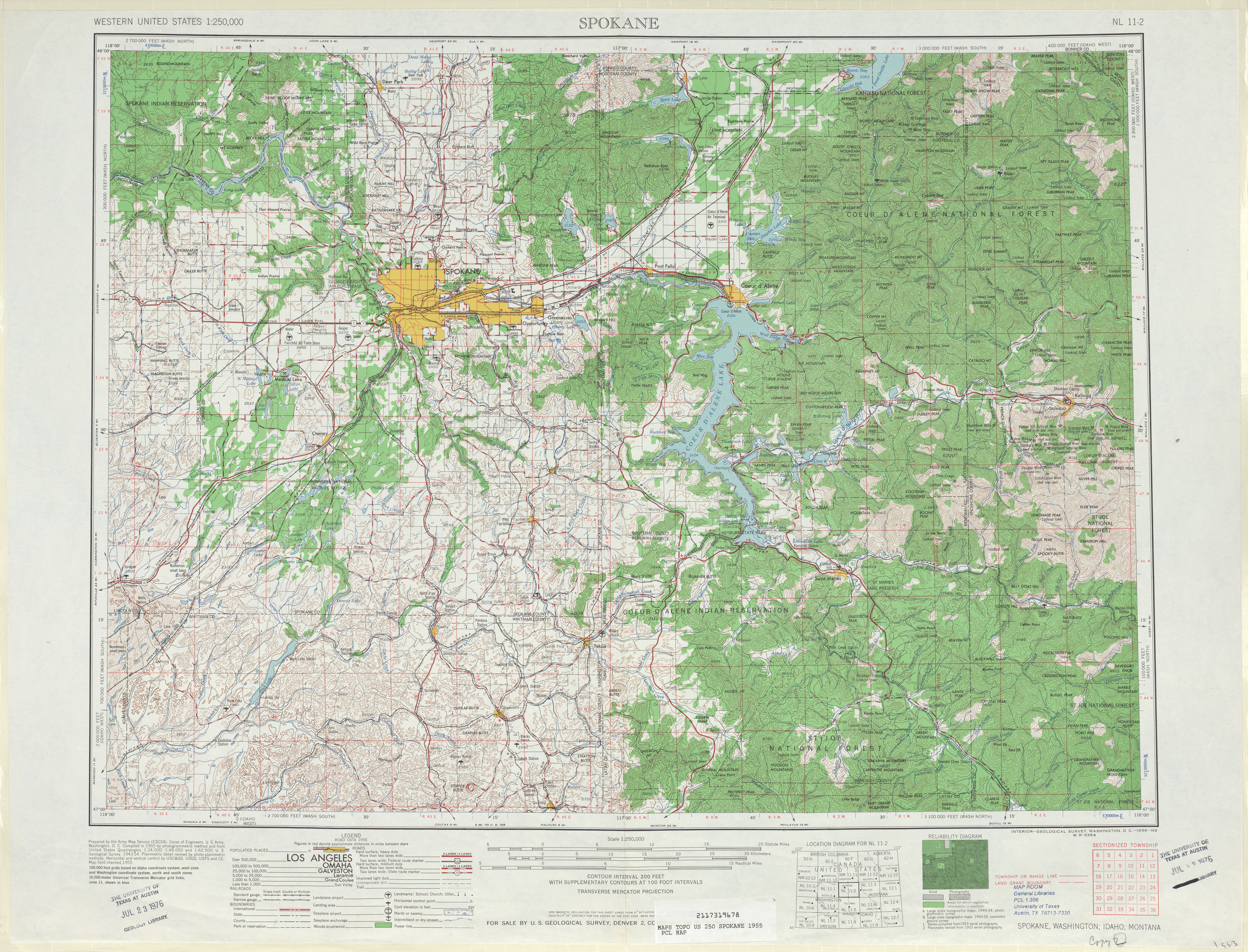
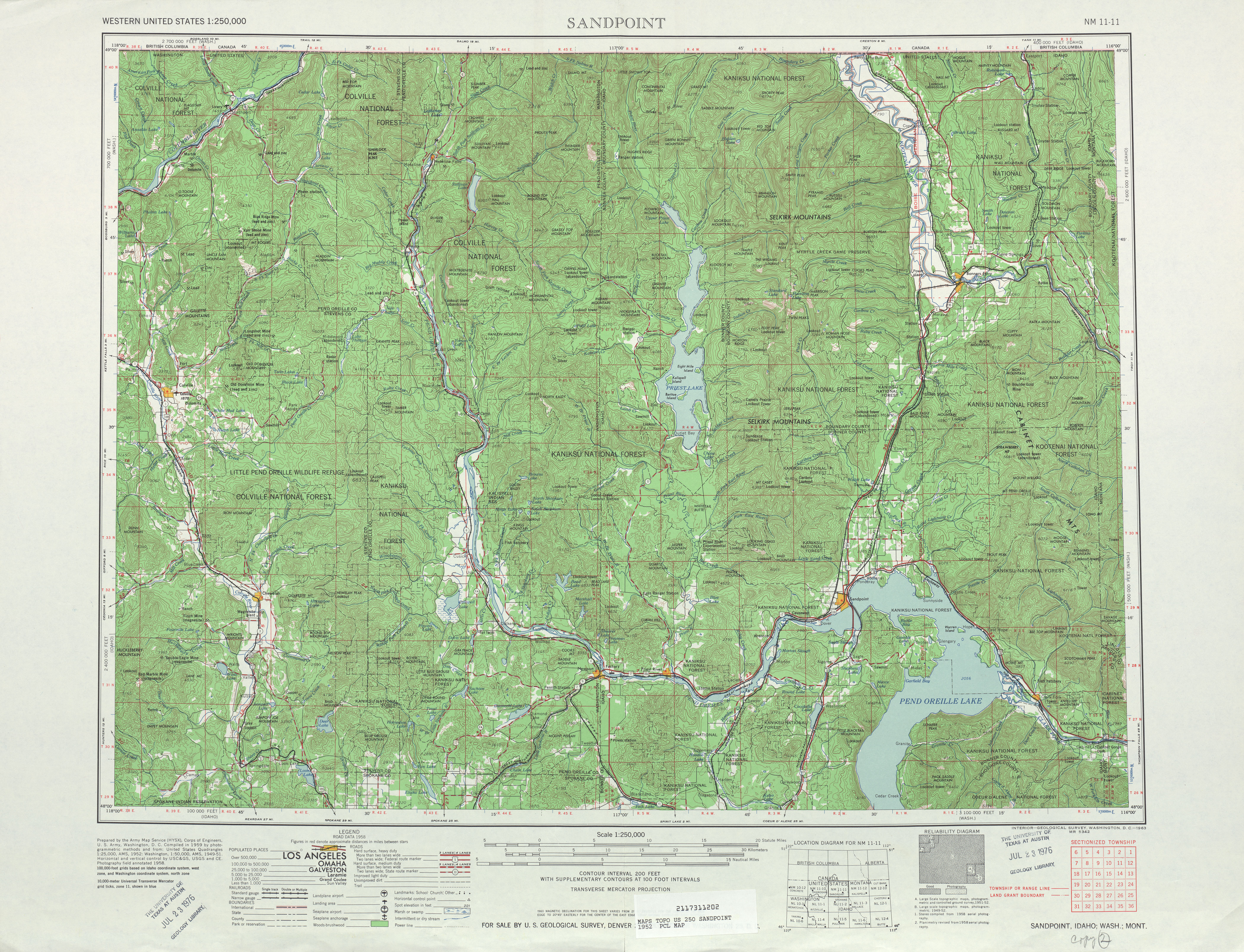
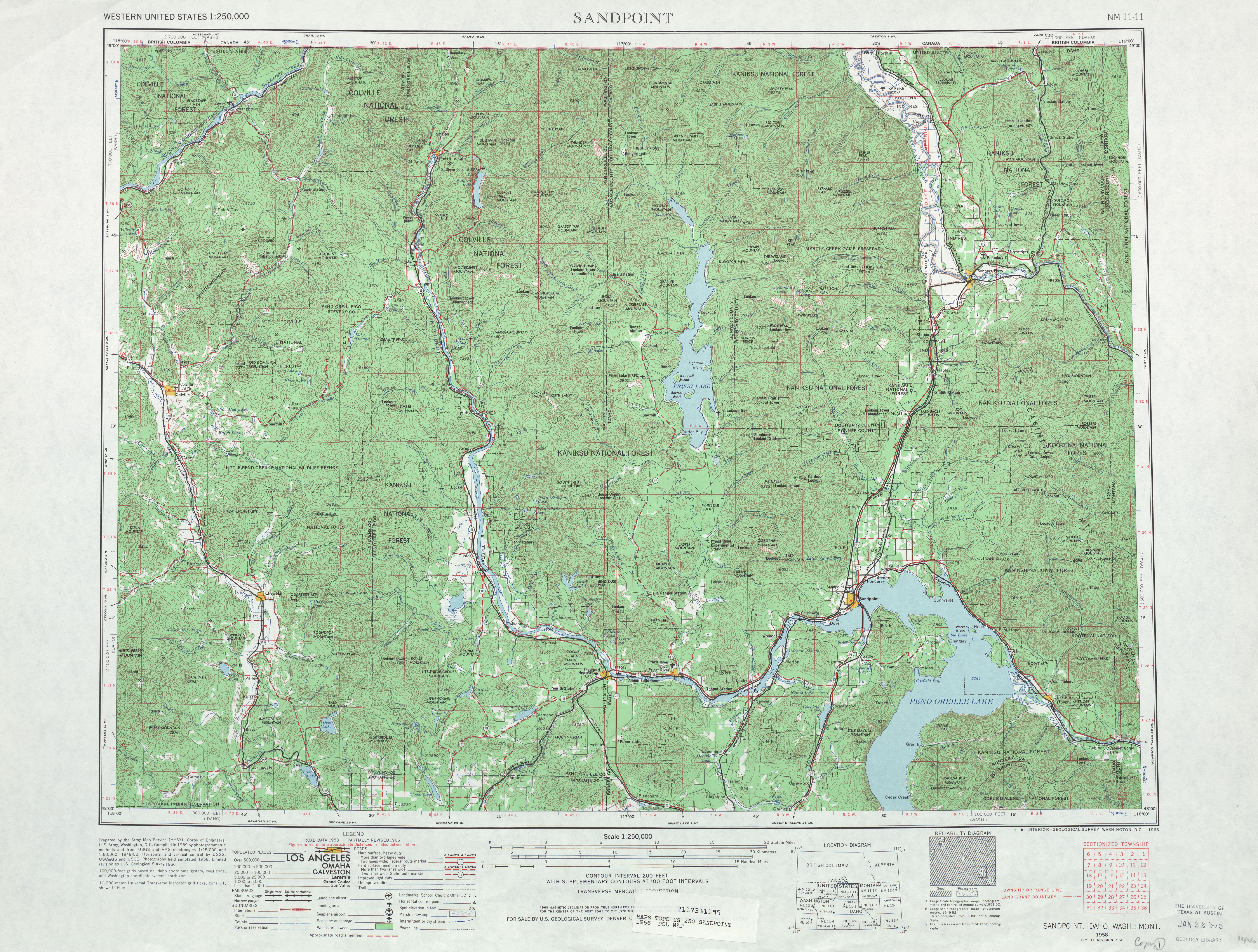
- Oppose. I echo many of the concerns above (image caption, random unencyclopedic stuff in the history, no RD pictures). Prose needs work.
- The highway parallels the Pend Oreille River for most of its route and connects Tiger, Ione, Metaline and Metaline Falls with British Columbia;[3] the route also parallels the Pend Oreille Valley Railroad from Tiger to Metaline Falls; the railroad extends south to Newport along SR 20 and east to Dover, Idaho.[4] - you can't combine two unrelated topics in one sentence.
- I find it hard to believe that it is called "Tiger E Road." Maybe Tiger East Road?
- parallel the shoreline of the Pend Oreille River and Pend Oreille Valley Railroad. - parallels both of them??
- The railroad crosses the road and later crosses the Pend Oreille River, as the highway turns northwest and reverts back northeast. - you use the same word twice!
- This is just a sample of the problems; please go through and clean up the prose. Reading this article makes me very uncomfortable. A-Class is not just GA-Class; it is a full review of an article before it goes to FAC. This article is nowhere near FA-Class or A-Class.
- Your heading structure for History just doesn't seem right. The organization seems to be off. That makes me uncomfortable as well.
- Either fix *all* of the above problems and do a thorough copyedit, or consider withdrawing this nomination. --Rschen7754 (T C) 07:16, 16 May 2009 (UTC)
If there is no attempt to resolve these issues by May 25 (Monday) then the article will be demoted. --Rschen7754 (T C) 22:42, 18 May 2009 (UTC)
I fixed all of your problems and will shortly get a copyediter on the job. –CG 15:21, 23 May 2009 (UTC)
- Uh, what about the random junk in the history section (which I had to remove myself)? What about pictures in the RD? Or the heading structure (which is still a mess?) -Rschen7754 (T C) 20:03, 23 May 2009 (UTC)
- If there is no attempt to resolve these issues by May 29 (Friday) then the article will be demoted. --Rschen7754 (T C) 03:27, 27 May 2009 (UTC)
- Demoted from what? –Juliancolton | Talk 16:11, 27 May 2009 (UTC)
- If there is no attempt to resolve these issues by May 29 (Friday) then the article will be demoted. --Rschen7754 (T C) 03:27, 27 May 2009 (UTC)
- The above discussion is preserved as an archive of the proposal. Please do not modify it. Subsequent comments should be made in a new section on this talk page. No further edits should be made to this section.
- The following discussion is an archived discussion of the proposal. Please do not modify it. Subsequent comments should be made in a new section on the talk page. No further edits should be made to this section.
The result of the proposal was promoted. –Juliancolton | Talk 01:08, 19 June 2009 (UTC)
Atlantic City – Brigantine Connector
Atlantic City – Brigantine Connector (edit | talk | history | links | watch | logs) review
- Suggestion: No suggestion given regarding A-Class
- Nominator's comments: I have worked on getting this article to GA and have since added better sources as well as some more information to the article. If this article passes, it will be the first New Jersey A-class article.
- Nominated by: Dough4872 (talk) 16:40, 8 April 2009 (UTC)
- First comment occurred: 22:52, 15 April 2009 (UTC)
- I hope to do a full review soon - but don't abbreviate AC and GS in the jct list - it's not like you're short on space in the table. Sources look valid, but ALL CAPS should not be used in the title (even though it may be in the title of the article; it's a Wikipedia thing). --Rschen7754 (T C) 22:52, 15 April 2009 (UTC)
- I have fixed the caps in the references, however, the abbreviations for the Atlantic City Expressway and Garden State Parkway are part of {{Template:Jct}} and are commonly used for many named roads in exit lists. Should I change the templates to show the name in full, rather than abbreviated, for those two roads as well as other named roads? Dough4872 (talk) 22:53, 16 April 2009 (UTC)
- Since abbreviations are fine for NJ 87 and US 30, they should be fine for the parkway and expressway as well. Plus, {{jct}} is occasionally used in infoboxes as well, so I wouldn't spell them out there. However, the use of periods should be consistent, i.e., since there are periods in "G.S.", they should be in "A.C." as well, and probably also after Pkwy and Expwy. -- Kacie Jane (talk) 15:29, 19 April 2009 (UTC)
- The title should be "Atlantic City – Brigantine Connector" per WP:MOSDASH: "All disjunctive en dashes are unspaced, except when there is a space within either one or both of the items," as is the case here. – TMF 03:04, 16 April 2009 (UTC)
Opposemainly for grammar issues, but one fairly important {{citation needed}}.- The "NJ" after the cities in the infobox seems superfluous to me. Also, if AC Expwy is abbreviated in the exit list, then it should be in the infobox as well. (If you do spell it out in the exit list, I would still abbreviate it in the infobox.)
- "The connector is 1.98 mi (3.19 km) long and maintained by the South Jersey Transportation Authority and is considered to be a state highway." – bit of a run-on sentence (I count 3 verbs)
- "The connector consists of lettered exits from A to H, increasing from south to north." – I'm not sure increasing is the correct word to use when describing letters, but it might still be valid. More importantly, the exit list mentions an Exit I, so which is it?
- "Approximately 25,000 cars travel on the connector daily, which features 16 bridges, 15 ramps, and 23 retaining walls." – These tidbits are mentioned in the lead, but not anywhere else in the article, and aren't cited.
- Using the entire name of the freeway three times in the single paragraph of the route description isn't necessary, and is cumbersome given how long and awkward the name is. Consider shortening it to "the Connector" after the first mention.
- "From Exit E of the Atlantic City – Brigantine Connector, a northbound ramp heads north, with Exit H serving Renaissance Pointe and the Borgata casino, Exit G for Huron Avenue, which provides access to Farley Marina and Trump Marina, and Exit I, which serves Harrah's Atlantic City." – This sentence is too awkward. First, "northbound ramp heads north" reads awkwardly. At first glance, I thought it was redundant, although I think I understand what it's trying to say now (a ramp off the northbound lanes heads in the northerly direction?). Secondly, it's not clear from reading it that the three exits are off that northbound ramp. Thirdly, the sentence is just long. I'd imagine that the best way to resolve my second point would be to split it into two sentences.
- "The Atlantic City – Brigantine Connector was also to feature a grade crossing of New Jersey Transit's Atlantic City Line" – The phrase "was also to" implies that they were originally planning to have an at-grade crossing, but after the opposition, they changed their minds. Since the route description section says the at-grade crossing does in fact exist, this sentence should be rephrased.
- Check the formatting of references. There are a couple of places where there's a space in between the period at the end of the sentence and the reference (the reference should be immediately after the punctuation), and at least once where there are two references in the wrong order (i.e. [11][6] instead of [6][11]).
- Hope this helps! – Kacie Jane (talk) 16:38, 19 April 2009 (UTC)
- Thanks for the review. I have replied to the above changes. Dough4872 (talk) 19:12, 19 April 2009 (UTC)
- At first glance, everything seems to be in order. I fixed two more things myself – first paragraph of the lead had two sentences in a row starting with "the connector", plus one more referencing tweak – but so far so good. As an aside, I noticed the number of bridges went down once it was referenced... *wink* – Kacie Jane (talk) 20:00, 19 April 2009 (UTC)
- Does your oppose still stand? --Rschen7754 (T C) 23:23, 24 April 2009 (UTC)
- I could honestly go either way on the article in it's current condition. I still have a few issues with the writing style; although since this might be mainly personal preference, I've struck through my oppose. The second sentence in the route description is what's catching my eye the most. "The road features its first exit, ..." In what way does it "feature" its first exit? Poor word choice there, as I don't think there's anything terribly special about that exit. It would be better of more simply as "The road's first exit is..."
- I'm not convinced that the article reads cleanly, but it's not necessarily enough for me to oppose its promotion. -- Kacie Jane (talk) 21:54, 30 April 2009 (UTC)
- Unresolved comments do oppose its promotion. --Rschen7754 (T C) 20:12, 11 May 2009 (UTC)
- What grammatical fixes are specifically needed in the article? Dough4872 (talk) 01:29, 12 May 2009 (UTC)
- I feel like I'm put in a bit of an awkward situation here. I don't want to lie and say that the article is perfect, because it's not. Then again, no article is, and that's why we have another class above A, and even the featured article template says that if you have ideas on how to improve it, do so. However, I also don't want to be the troll standing in the way of this nomination. I was asked if my oppose still stood, and I thought I answered that question in a clear albeit verbose manner. My previous response was meant to be read as, "This article is good enough to be A-class, but here's some things you may want to work on before you take it to FAC."
- As I said before, any issues I still have with the article are primarily personal preference – as in, "This isn't how I would have worded this. I don't think it's the best way to say it, but the person who wrote it probably does." Personally, I'm of the opinion that nitpicking every last word choice and comma isn't the type of thing we should be doing here, or even at FAC.
- All this being said, if necessary, I can probably get around to doing another round of (more specific) comments later on today – although I'd prefer not to if this article can pass without them. (I have other wiki-projects that I've been putting off for a week now.) – Kacie Jane (talk) 17:23, 12 May 2009 (UTC)
- What grammatical fixes are specifically needed in the article? Dough4872 (talk) 01:29, 12 May 2009 (UTC)
- Unresolved comments do oppose its promotion. --Rschen7754 (T C) 20:12, 11 May 2009 (UTC)
- Does your oppose still stand? --Rschen7754 (T C) 23:23, 24 April 2009 (UTC)
- At first glance, everything seems to be in order. I fixed two more things myself – first paragraph of the lead had two sentences in a row starting with "the connector", plus one more referencing tweak – but so far so good. As an aside, I noticed the number of bridges went down once it was referenced... *wink* – Kacie Jane (talk) 20:00, 19 April 2009 (UTC)
Comments
- I'm confused by the words in the lead "with Route 87 to Brigantine, New Jersey," does that mean the connector is routed concurrent with Route 87 until arriving at Brigantine, or the connector terminates at Route 87 just outside of Brigantine.
- "Mirage Resorts president Steve Wynn" I think Steve Wynn should be set apart in comma's, but might want to consult someone more proficient with grammar than myself.
- "who owned the nearby Trump Marina" should definitely be set apart with commas.
- "while Trump’s casino received a direct ramp from the connector." Doesn't really fit in with the rest of that sentence. Suggest deleting or wording into a new sentence.
- Per WP:$ the first instance of $ does not need to be linked on US specific articles.
- "New Jersey Transit's Atlantic City Line. Two wikilinked terms should not be placed together if there is an easy way to separate them.
- "it comes to" is used a little to much in the article. Try to find alternate wordings.
- state of New Jersey
officiallyannounced. Officially is implied with the fact that the announcement is from the government. - ($400 million today) -> (equivalent to $400 million in 2009)
- This wording is part of Template:Inflation and cannot be changed. Dough4872 (talk) 14:43, 24 April 2009 (UTC)
- The italicized "87" in the mile list is never explained. If it is referring to route 87 mileposts being used, I disagreed with 2 road FAC's using this convention. Had I not seen other articles that used that convention. I would honestly believe the milepost is 87.xxx with the 87 being italicized on the milepost. To see how other articles have handled this see U.S. Route 50 in Nevada or California State Route 78.
- MGM Mirage is wikilinked twice in the same paragraph.
My apologies it took so long to get to this. There's a lot going on in wikipedia land and I've been swamped. Dave (talk) 03:20, 24 April 2009 (UTC)
- Thanks for the review. I have replied to the above changes. Dough4872 (talk) 14:43, 24 April 2009 (UTC)
Support I did delete one SR 87 milepost that was forgotten. I didn't know there was an inflation template to guarantee the template would be current. Cool. I could have used this on a few articles.
- Support, excellent work. –Juliancolton | Talk 03:25, 3 May 2009 (UTC)
Additional comments from Kacie Jane
- The first sentence can be reworded to say "New Jersey" only once. Simply removing it from the Brigantine link would be sufficient, but try to think of even cleaner ways to do it.
- Second sentence, there's no reason to abbreviate miles there.
- I would combine the last two sentences of the first paragraph – "in north to south order, and features ten bridges..." This comment in particular is just my personal preference, but the last sentence seems choppy to me.
- In both the lead and the history section, "Le Jardin" is in quotes when it probably shouldn't be. (Elsewhere in the history section, it appears without quotes.) Additionally, the word "the" should be removed before the name in the lead.
- The second paragraph in the lead should probably be reordered, expanded, and/or split into two. While I realize it matches the chronological order of the history section, in the lead it reads as a single sentence on the planning, a whole bunch about the casinos, and then another single sentence about the completion. The first and last sentence work well together, but with all the casino talk in between, the last sentence seems to come out of nowhere.
- The first sentence in the route description should be reworded so that it doesn't use the words "Atlantic City" four times.
- The third, fourth, and fifth sentences all begin with the word "Past." "Past that interchange, ..." "Past the railroad line, ..." "Past Bacharach Boulevard, ..." Shake up the wording a bit.
- The third sentence again contains the words "Atlantic City" three times. Two of these were also in the first sentence, so there should be a way to easily avoid using the full names here.
- The end of the route description still needs some cleanup to explain what's going on with the mainline and the Exit E ramp. The way it's written now, it goes from Exit E to Exit F, then jumps back to Exit E. Instead, the article should mention the split where it first talks about Exit E, then list the exits off the mainline, then the exits off the connector.
- Beach Thoroughfare – coming from a roadgeeking background and not caring a bit about boats, my assumption when I hear the word thoroughfare is some sort of super arterial, but this appears to be a fairly important body of water. I would link it, even though it's a redlink at the moment. Also, Beach Thorofare seems to be the more common spelling.
- The last sentence of the first paragraph of the history section still needs work. (By putting the words "which was built" there, you're stressing the fact that it was built before you've given the reader any reason to doubt that it would have been.) More importantly though, there's a hole in the article's coverage. If these two groups opposed it, why was the at-grade crossing still built? Even if that one source from DVARP is all you have, explain that it was built because it was the cheapest option. Then you can avoid wording problems in the current sentence by adding a new sentence afterwards. "The proposal for the at-grade crossing was opposed because... However, it was built because..."
(Contrast this with the following paragraph about the casinos. If Donald Trump opposed it, why was it still built? Because he got an exit ramp built to his casino too.)
Sorry this nomination is taking so long. Hopefully this will be the final round of comments. – Kacie Jane (talk) 00:45, 13 May 2009 (UTC)
- Thanks for looking over the article again, I have replied to the above suggestions. Dough4872 (talk) 02:03, 13 May 2009 (UTC)
- I really like the way you applied my suggestions, particularly the second paragraph of the lead, and the "spiced" wording in the route description. The only place I'm still having trouble is the E-F-G-H-I mess in the route description section. Looking at a map of the area, I do appreciate all the hard work that's been done, since writing a route description of a spaghetti bowl interchange is inherently difficult. The major flaws I'm seeing right now are (a) that the article implies that F is an exit on the mainline when it's actually a ramp from the northbound ramp to the mainline and (b) that the article text implies that G-H-I are northbound only exits whereas the exit list notes imply that there are exits in both directions and that the southbound exits are merely unlettered. The map provided at Ref 14 seems to imply that these exits do in fact exist southbound. I think the problem is that the route description is concise to the point of being inaccurate.
- I'm going to be offline for about 10 hours (work IRL), but when I got back I was planning on taking another look at maps and other sources to see if I could take a hack at it myself. But of course, feel free to make any improvements yourself and/or leave me messages on my talk page in the meantime. -- Kacie Jane (talk) 03:40, 13 May 2009 (UTC)
- I have moved the sentence about Exit F with the information about the northbound ramp. As for the ramp, it is northbound-only. Southbound traffic must use NJ 87 to access the connector at exit D. I clarified this in the route description. Dough4872 (talk) 03:55, 13 May 2009 (UTC)
- I think the issue derives from the unnecessary distinction between a "mainline" and the northbound ramp. In fact, I would argue that the northbound ramp actually is the mainline. While I realize that NJDOT logs the highway from the ACE to US 30, I think that's primarily for their own convenience (it's kind of a pain to log a single-direction highway with a slew of ramps, and keep in mind they're not the maintaining agency here). Since the exit letters increase from A to I along a specific path, I think it only makes sense to treat that as the mainline, rather than deal with awkward wording about exits off a northbound-only ramp. The reason I was having so much trouble deciphering the route description was because I was interpreting it to mean that Exit E went to US 30, Exits G H and I were on a separate ramp that diverged somewhere around the vicinity of Exit E, and that there was a third split that continued to the northern terminus at NJ 87.
- Here are a couple of related comments that really need to be fixed before I'll fully support promoting the article to A-class:
- The length in the infobox is listed as 1.98 miles. However, the termini are listed as the ACE and NJ 87, and the distance between these two points on the connector is 2.5 miles according to Google.
- The use of NJ 87 mileposts in the junction list is rather incorrect. There's no concurrency, so you don't have a point where a Connector milepost is equal to a milepost on NJ 87. As a result, it's impossible to determine from the junction list what the distance between Exits F (Conn MP 1.59) and H (NJ 87 MP 0.46) is, defeating the purpose of having the mileposts in the table. Additionally the points used for the mileposts are arbitrary, since they're not on the connector itself. The milepost for Exit G is the intersection between NJ 87 and NJ 187, which is 1/10 mile east of where the Connector actually crosses over Huron Avenue.
- The final line in the exit list needs a milepost. When the notes say "Continuation beyond wherever", it's because one designation ends at that particular interchange/junction, and another designation starts there. Here the Connector still continues (albeit only for a tiny bit) before it merges into NJ 87 northbound, so it should have a separate milepost for the terminus.
- Relatively speaking, this is extremely minor, but the line for Exit G in the exit list needs a formatting fix (a spaced en dash between the road and the destination).
- Let me know if I can be of service or further explain my comments. – Kacie Jane (talk) 02:33, 15 May 2009 (UTC)
- I have moved the sentence about Exit F with the information about the northbound ramp. As for the ramp, it is northbound-only. Southbound traffic must use NJ 87 to access the connector at exit D. I clarified this in the route description. Dough4872 (talk) 03:55, 13 May 2009 (UTC)
- There are really just way too many inconsistencies and vagueries for this article to be A-class. The exit list seems to indicate that the southbound lanes begin at NJ 87, but the route description isn't clear on the matter. However, since Exit E to US 30 is a two-way ramp, the southbound lanes should be considered to begin there. I'm not sure why the note about Ramp D is included on the same line as Exit E on the exit list, since the two exits are a good distance apart. (D should probably have its own line, even if it is entrance only.) The mileposts for Exit E is wrong – 1.40 is where the connector crosses over Huron Avenue at ramp D.
- The way the Google map is currently linked, it lists the length as 2.3 miles – if it's being used as a reference, the numbers have to match. (To get 2.5, I used the point where the ramp diverges from the ACE mainline, which is the same starting point the SLD uses.) Also, this article cannot pass unless the mileposts for the three ramp exits are replaced with mileposts from the actual connector. The route description still has a sentence at the end about the Exit E ramp that seems to come out of nowhere, and could use a fleshing out in general; it really tries to do too much with a single paragraph. Specifically, there needs to be more mention of NJ 87's role in serving southbound traffic. If the purpose of building this connector was to connect the ACE with the casinos and Brigantine, but half the connector is northbound only, how does traffic get back? (Also, the note for Exit E in the exit list says that southbound traffic must use the Borgata exit, but the note two rows down says that there is no Borgata exit southbound. There is an exit, it's just technically on NJ 87 rather than the Connector.)
- While I do want this article to succeed, it seems to be a lot further than I thought it was on my first viewing. I'd really appreciate it if another member of the project would come along and do a full review to see if we can help this article along. – Kacie Jane (talk) 05:31, 18 May 2009 (UTC)
- I have taken a good look at the article and have tried to sort out the mess concerning the ramps. In both the route description and the exit list, I have made it more clear that NJ 87 provides southbound access for the points served by the northbound-only portion as well as indicating that Exit E marks the beginning of the southbound direction of the connector. I have added a row for Ramp D to show that it is a southbound entrance from NJ 87. Also, I fixed the Google Maps link to show the connector beginning at the ramp from the ACE. Unfortunately, I cannot get the mileposts for the exits along the northbound-only portion of the connector since the SLD has the connector go off to US 30 at Exit E. If anyone can find a way to get mileposts for the exits, I would appreciate it. Dough4872 (talk) 15:22, 18 May 2009 (UTC)
- Comments:
- The first sentence of the lead runs on a bit too long. I'd split it in two after "New Jersey". ("...is a highway connector in Atlantic City, New Jersey, United States. It connects the Atlantic City Expressway...)
- The precision in the infobox needs to be adjusted to match the given mileage.
- The first two sentences of the route description begin with "The road". One of them should be changed.
- "Thorofare" or "Thoroughfare"? The former seems odd, but if that's the actual name it can't be helped.
- I'm reading through the description and the way the third sentence of it is worded is a bit odd. "...a four-lane, 35 mph (56 km/h) freeway, passing under the expressway..." is what's really tripping me up. On first read, it's not clear what the "expressway" is; however, I was able to figure it out by way of the map. The description should make some mention of how the connector begins near the east end of the ACE, heads west on a routing parallel to it, then curves north along the riverbank to pass under the ACE. I find this routing interesting and wouldn't have known this was the routing it took if not for the map. The map should be a supplement to the description and not a replacement for it.
- Fifth sentence: "Beach Throughfare" - see above; which is it? Also, "running through a tunnel." - what does the tunnel pass through/under?
- "served by the northbound direction of the connector further to the north such as the Borgata, Trump Marina, and Harrah's Atlantic City casinos." - maybe move "further to the north" to the end of the sentence? As it is now, it reads slightly awkwardly.
- "The freeway heads to Exit E, which is a northbound exit and southbound entrance" - I'd drop the "which is" here. I've noticed that "which is" is used a lot, maybe to a fault, in the description. Some of these uses should be eliminated where possible.
- "From Exit E, the connector continues a northbound-only road" - I'd insert "as" in between "continues" and "a".
- The second paragraph reads like a prose version of the exit list. According to the map, the freeway turns east somewhere, but there's no mention of this in the description.
- I'd appreciate it if some labels could be added to the map, especially for the orange state highway/U.S. highway lines. As someone who has no knowledge of the New Jersey road system, the shields would definitely improve my understanding of the highway's routing.
- In the history now: "running from the Atlantic City Expressway north to the Marina districe" - district?
- "Atlantic City government requested proposals for a property" - proposals/bids to purchase it? Based on the following sentence, that's what I assume it means but it's not explicitly clear.
- "not scheduled to open until 2003, Trump was still fighting against" --> "Trump still fought"
- "after an exit ramp leading to the Trump Marina was later added to the project." - Considering the way the beginning of the sentence is worded, I'd drop the "later" since I assume that Trump dropped his case as a result of the addition of the ramp.
- "The grand opening ceremony was open to the public, which featured various festivities, including a pedestrian tunnel walk, all of which was open to the public." - open to the public is stated twice.
- "Once the connector opened to traffic, the exit ramps leading to the Borgata were still under construction along with the resort itself, and the ramps did not open up until October 2003." - maybe rewording the sentence to begin like "Although the connector itself was open to traffic, the exit ramps..." would make more sense.
- I'd reformat the inflation conversion to use available inflation calculation templates instead, such as those on New York State Route 531. That way, the conversion will be automatically updated every year.
- I'm not a fan of explicitly mentioning termini in junction lists, but considering how unorthodox this highway is, I suppose I can understand their inclusion.
- Exit E's notes should be "Northbound exit and southbound entrance" for consistency with the first two exits.
- Since the Route 446X straight line diagram is being used as a reference, I'd remove it from the external links.
- I understand the South Jersey Transportation Authority maintains the highway, but I'm not sure how relevant an external link to their website is here. If a reader wants more information on the authority, they can visit our article on it, where they can then go to their website if they want to know more.
- I'd add the year of the SLD to the reference, if available.
- I'd also consider reversing the alignment of the two pictures in the article. On my layout, the right-aligned image combines with the infobox to make the top of the article a bit lopsided to the right. What I'd consider is moving this image to the left (which probably would require placing it before the second paragraph of the description per WP:MOSIMAGES - it doesn't talk about second-level headers being affected by left-aligned pictures to start a section, but it used to) and moving the history image to the right. Even if this is not done, the history picture probably needs to be moved down a paragraph for the reason given above. – TMF 04:11, 19 May 2009 (UTC)
- Fixed images. Dough4872 (talk) 15:26, 19 May 2009 (UTC)
- Thanks for the review. I have replied to the above comments. Dough4872 (talk) 15:26, 19 May 2009 (UTC)
- OK, everything looks good. I also made some small tweaks to the article, mostly minor punctuation changes. There are only two issues preventing me from supporting the article, and both relate to the map. The first is the lack of shields, which I commented on above and I understand is in the process of being fixed. The other, however, is that the map doesn't appear to show the northbound-only part of the connector. I'm comparing our map of the connector to a commercial map of the area, and our map gives the impression that both directions of the connector end at and merge with US 30. – TMF 17:57, 19 May 2009 (UTC)
- The map that was made for the article was based on the SLD, which falsely shows the connector ending at US 30 rather than continuing up the northbound ramp to NJ 87 near the Brigantine Bridge. The SJTA map of the connector would be a better model for our map. I have also notified the MTF that the map needs to be fixed to show the correct route. Dough4872 (talk) 18:01, 19 May 2009 (UTC)
- OK, everything looks good. I also made some small tweaks to the article, mostly minor punctuation changes. There are only two issues preventing me from supporting the article, and both relate to the map. The first is the lack of shields, which I commented on above and I understand is in the process of being fixed. The other, however, is that the map doesn't appear to show the northbound-only part of the connector. I'm comparing our map of the connector to a commercial map of the area, and our map gives the impression that both directions of the connector end at and merge with US 30. – TMF 17:57, 19 May 2009 (UTC)
- Thanks for the review. I have replied to the above comments. Dough4872 (talk) 15:26, 19 May 2009 (UTC)
- Fixed images. Dough4872 (talk) 15:26, 19 May 2009 (UTC)
What is the status of this nomination? --Rschen7754 (T C) 04:07, 6 June 2009 (UTC)
- It has three support votes, just need maybe a couple more reviews and Kacie Jane to look over it again. Dough4872 (talk) 00:48, 7 June 2009 (UTC)
- Yeah, at this time I don't believe that Kacie Jane's comments are sufficient to fail this nomination. --Rschen7754 (T C) 01:03, 10 June 2009 (UTC)
- The above discussion is preserved as an archive of the proposal. Please do not modify it. Subsequent comments should be made in a new section on this talk page. No further edits should be made to this section.
New York State Route 254
_map.svg)
- The following discussion is an archived discussion of the proposal. Please do not modify it. Subsequent comments should be made in a new section on the talk page. No further edits should be made to this section.
The result of the proposal was Not promote; several unresolved issues. --Rschen7754 (T C) 19:30, 17 September 2009 (UTC)
New Jersey Route 31
New Jersey Route 31 (edit | talk | history | links | watch | logs) review
- Suggestion: No suggestion given regarding A-Class
- Nominator's comments: Originally a Good Article written by Dough4872, I have taken this article and given it some major work, mainly in how the highway was constructed and the use of references in the article. I hope at this point, it is suitable for A-class.
- Nominated by: Mitch/HC32 18:07, 30 June 2009 (UTC)
- First comment occurred: 03:25, 1 July 2009 (UTC)
- Review by TMF
- The bolded text at the article's outset violates WP:USSH for New Jersey.
- Done.
- "Much of Route 31 is a two-lane country road running through farmland, woodland, and mountainous areas, except for the portion of the route north from Trenton to Pennington, six miles (10 km) in Hunterdon County, where it is concurrent with U.S. Route 202, and between Flemington and Clinton" - the sentence begins by talking about the route's surroundings, then it jumps into concurrent routes and various segments along the highway. What kinds of areas does the route pass through from Trenton to Pennington, et al? The text implies that they're not rural areas, but it doesn't say what exactly they are.
- Done.
- "The alignment of the highway was constructed from 1926 to 1935 along its entire alignment to Buttzville from Trenton." - incredibly awkward wording.
- Done.
- I skipped ahead after reading that sentence and I must say that the entire article needs a good copyedit. Once this is done, I'll give this another, more detailed review. – TMF 03:25, 1 July 2009 (UTC)
- Comments by Dave
If a copyeditor is on the way, I'll wait until cleaned up before doing a detailed review. However I've got a couple of points.
- IMO if a way can be elegantly found to move the historical marker image to be the lead image, IMO that's a much better photo than one with visible windshield tinting in 1/3rd the photo. However, this will take some work to have it fit in that way.
- Image cropped to remove tinting and other stuff. –Juliancolton | Talk 01:36, 14 July 2009 (UTC)
- I will copyedit the article as I was a major contributor. Dough4872 (talk) 22:10, 14 July 2009 (UTC)
- I have gone through and copyedited the article, fixing wordings and removing many needless county route intersections. However, I have two concerns with the Construction section. First, what is "when a long time set of legislative enactments" supposed to mean? Second, the first paragraph of this section seems to describe the construction of the route while the second paragraph describes bridge information and more redundant construction information that seems to contradict what was said in the first paragraph. Can this section be rewritten to make it sound more clear? Dough4872 (talk) 22:43, 14 July 2009 (UTC)
- Second review by TMF
Sorry to be blunt, but the lead is still a mess. "The excepttions to this are the portion of the route north from Trenton, a highly developed city to Pennington, one of the capital's suburbs, six miles (10 km) within Hunterdon County, where it is concurrent with U.S. Route 202, and between Flemington and Clinton, where the highway is mainly commercial." - long, winded run-on. "The highway was constructed from 1926 to 1935, running between Buttzville and Trenton." - awkward wording. "There were plans made in the late 1960s and early 1970s to build a freeway that would serve the Route 31 corridor from the Trenton area to northwestern New Jersey as far north as Interstate 84 in Port Jervis, New York;" - the part after northwestern New Jersey seems like a poorly-worded tack-on point. It could be used, however, by reworking the sentence entirely ("build a freeway in the Route 31 corridor that would begin in the Trenton area and extend as far north as Interstate 84 in Port Jervis, New York" - something like that.). The only items I thought were completely fine in the lead were those in the beginning of the second paragraph talking about the change in designations. Other than that, it was disheartening to see the lead still in poor shape, which is what prompted me to call off my initial review.- The lead is better; however, there's still some awkward/confusing phrasing. Among them: the opening sentence tries to squeeze in a description of the entire route; however, that type of detail should be reserved for the sentences that follow. I'd move the "...with two exceptions" to the start of the next sentence, which would then begin "Two exceptions to this exist..." or something like that. Also: "north from Trenton to the suburb of Pennington is predominantly built-up while the portion between Ringoes and Clinton, including the concurrency with U.S. Route 202, is mainly commercial." - wouldn't it be sufficient to just say that both areas are built-up? "The highway was constructed from 1926 to 1935 between Buttzville and Trenton." - since the termini listed here are the same as the modern route, I question the necessity of their inclusion here. "In recent years, Route 31 saw extensive construction projects between Flemington and Clinton that widened the road to four lanes." - routes have eyes? "In addition, a failed project was proposed to build a bypass of Flemington that would have also eliminated the Flemington Circle." - using both "failed" and "proposed" in the same sentence seems awkward to me.
- I broke the first sentence in the lead into three sentences. I rewrote the last sentence oin the lead. I removed the "between Buttzville and Trenton" as it is redundant. The sentence ""In recent years, Route 31 saw extensive construction projects between Flemington and Clinton that widened the road to four lanes." has been reworded to aviod use of "saw". I reworded the last sentence of the lead to avoid contradiction. Dough4872 (talk) 01:16, 7 August 2009 (UTC)
- It's getting there. There are still some awkward sentences: "There are two exceptions with the portion of the route north from Trenton to the suburb of Pennington and between Ringoes and Clinton, including the concurrency with U.S. Route 202, built-up." - built-up seems like a tack-on point. "In recent years, there have been extensive construction projects along Route 31 between Flemington and Clinton that widened the road to four lanes." - could just say that that portion of the route has been widened to four lanes in recent years. – TMF 03:34, 7 August 2009 (UTC)
- I broke the first sentence in the lead into three sentences. I rewrote the last sentence oin the lead. I removed the "between Buttzville and Trenton" as it is redundant. The sentence ""In recent years, Route 31 saw extensive construction projects between Flemington and Clinton that widened the road to four lanes." has been reworded to aviod use of "saw". I reworded the last sentence of the lead to avoid contradiction. Dough4872 (talk) 01:16, 7 August 2009 (UTC)
- The lead is better; however, there's still some awkward/confusing phrasing. Among them: the opening sentence tries to squeeze in a description of the entire route; however, that type of detail should be reserved for the sentences that follow. I'd move the "...with two exceptions" to the start of the next sentence, which would then begin "Two exceptions to this exist..." or something like that. Also: "north from Trenton to the suburb of Pennington is predominantly built-up while the portion between Ringoes and Clinton, including the concurrency with U.S. Route 202, is mainly commercial." - wouldn't it be sufficient to just say that both areas are built-up? "The highway was constructed from 1926 to 1935 between Buttzville and Trenton." - since the termini listed here are the same as the modern route, I question the necessity of their inclusion here. "In recent years, Route 31 saw extensive construction projects between Flemington and Clinton that widened the road to four lanes." - routes have eyes? "In addition, a failed project was proposed to build a bypass of Flemington that would have also eliminated the Flemington Circle." - using both "failed" and "proposed" in the same sentence seems awkward to me.
Description: "The route passes by residences and crosses County Route 653 (Calhoun Street) and then enters Ewing Township where it crosses County Route 634 (Parkway Avenue)." - slight run-on. However, that was the only glaring thing that jumped out at me in terms of flow. Now, I must say, having re-read the B-W Parkway description right before reading this one, this description does not have as much "life" as the other one. I think if I had to assess this article's description, I would say that the second half (from about the second paragraph of Huntington County on) was better than the first in terms of a true description of the route - scenery, sights, surroundings, etc.- Again, better, but still has issues. The first paragraph of the Mercer County subsection suffers from a series of short sentences that doesn't really establish a flow. In terms of the RD as a whole, I see a clear overuse of "the route"; in fact, I think I saw "the route" more times than I saw "Route 31". Also, there are some areas of the RD, specifically toward the middle, where it reads like a list of communities along the route.
- I have made some tweaks to the first paragraph of the RD to allow for better flow. I have replaced some of the instances of "the route" in the route description. I don't see how parts of the RD read like a list of communities as major intersections and physical features are presented throughout. Dough4872 (talk) 01:16, 7 August 2009 (UTC)
- One section I can see: "The route crosses into Lebanon Township, where it heads northwest across the Musconetcong Mountains. It enters Glen Gardner where the route crosses Spruce Run.[1][2] Route 31 heads through Glen Gardner before heading into Hampton, where it heads west through that community as a three-lane road with two southbound lanes and one northbound lane." - the whole thing basically follows a format of naming a location then mentioning an item in the area. In this instance, if it doesn't cross anything notable in Glen Gardner, I'd simply say the route passes through it and wouldn't devote parts of two sentences to it. – TMF 03:34, 7 August 2009 (UTC)
- I have made some tweaks to the first paragraph of the RD to allow for better flow. I have replaced some of the instances of "the route" in the route description. I don't see how parts of the RD read like a list of communities as major intersections and physical features are presented throughout. Dough4872 (talk) 01:16, 7 August 2009 (UTC)
- Again, better, but still has issues. The first paragraph of the Mercer County subsection suffers from a series of short sentences that doesn't really establish a flow. In terms of the RD as a whole, I see a clear overuse of "the route"; in fact, I think I saw "the route" more times than I saw "Route 31". Also, there are some areas of the RD, specifically toward the middle, where it reads like a list of communities along the route.
- History:
"The origins of State Route 31 date back to the years of 1909–1917, when a long time set of legislative enactments, the New Jersey State Legislature formed the New Jersey State Highway Department." - I'm not really sure what this sentence is trying to say. What's a "a long time set"?- "The origins of State Route 31 date back to 1909–1917, when a long set of legislative enactments, including the formation of the New Jersey State Highway Department," - this makes no sense. What does this have to do with Route 31? And why "State Route 31"?
- Redone.Mitch32(Want help? See here!) 00:46, 10 August 2009 (UTC)
- I still don't see how it explicitly relates to Route 31. Did New Jersey establish a state highway system as part of the creation of the state highway department? If so, was what became Route 31 among the roads included in said system? If it wasn't, it really isn't worth mentioning in an article on Route 31. – TMF 04:25, 21 August 2009 (UTC)
- Still an issue. – TMF 21:16, 5 September 2009 (UTC)
- Done.Mitch32(The Password is... See here!) 22:17, 8 September 2009 (UTC)
- Still an issue. – TMF 21:16, 5 September 2009 (UTC)
- I still don't see how it explicitly relates to Route 31. Did New Jersey establish a state highway system as part of the creation of the state highway department? If so, was what became Route 31 among the roads included in said system? If it wasn't, it really isn't worth mentioning in an article on Route 31. – TMF 04:25, 21 August 2009 (UTC)
- Redone.Mitch32(Want help? See here!) 00:46, 10 August 2009 (UTC)
- "The origins of State Route 31 date back to 1909–1917, when a long set of legislative enactments, including the formation of the New Jersey State Highway Department," - this makes no sense. What does this have to do with Route 31? And why "State Route 31"?
"From 1923–1933, the state enacted the "Good Roads" Act, which greatly expanded the state highway system in New Jersey." - was it a set of legislation that was passed over a span of 10 years or did it take 10 years to carry out the construction specified in an act passed in 1923? I assume it's the latter, but if so it's a weird way of putting it.- "and from 1923–1933, the state enacted the "Good Roads" Act, which greatly expanded the state highway system in New Jersey" - weird way of phrasing this. I'd go with something like "In 1923, the state of New Jersey passed the Good Roads Act, which..." and then explain how it was enacted over the next decade.
- Fixed.Mitch32(Want help? See here!) 00:46, 10 August 2009 (UTC)
- "In 1923, the state of New Jersey passed the Good Roads Act, which greatly expanded the state highway system in New Jersey." - so basically it's the same thing as above with a couple of words stripped out. It's still way too vague. How did it expand the system? Did the state take over pre-existing highways? Did the state construct new highways? It's not at all clear. – TMF 04:25, 21 August 2009 (UTC)
- Fixed.Mitch32(Want help? See here!) 00:46, 10 August 2009 (UTC)
- "and from 1923–1933, the state enacted the "Good Roads" Act, which greatly expanded the state highway system in New Jersey" - weird way of phrasing this. I'd go with something like "In 1923, the state of New Jersey passed the Good Roads Act, which..." and then explain how it was enacted over the next decade.
"The highway from Trenton to Buttzville began construction in 1926" - it built itself?"Construction began from Trenton to Buttzville in 1926 with the southern terminus in Trenton" - did construction on the entire route begin in 1926? If not, this sentence is highly misleading."A total of 11 bridges were constructed along the highway during this time." - I don't see the significance of this."During 1930, the construction had reached Clinton,[7] Glen Gardener,[8] and Washington,[9] where the route currently runs" - why was "where the route currently runs" added here?
- Done.Mitch32(Want help? See here!) 00:46, 10 August 2009 (UTC)
- "The route's construction progressed northward, with the nine sections of highway reaching Hunterdon County" - I'm not sure of the meaning of "nine sections" here. Was the route composed of simultaneously constructed pieces?
- This is still an issue. I seem to understand what the sections are now, but did New Jersey number them as they were built? If not, why are we?
- The citation seems to have numbered them :| - Mitch32(Want help? See here!) 00:46, 10 August 2009 (UTC)
- I still don't see the need to number them if the sections were completed in order from south to north. – TMF 04:25, 21 August 2009 (UTC)
- "The route's construction progressed northward, with the sections of highway reaching Hunterdon County, where the highway was constructed between April and October 1931." - long winded and fragment-filled sentence. Needs copyediting. – TMF 21:16, 5 September 2009 (UTC)
- Done.Mitch32(The Password is... See here!) 22:17, 8 September 2009 (UTC)
- "The route's construction progressed northward, with the sections of highway reaching Hunterdon County, where the highway was constructed between April and October 1931." - long winded and fragment-filled sentence. Needs copyediting. – TMF 21:16, 5 September 2009 (UTC)
- I still don't see the need to number them if the sections were completed in order from south to north. – TMF 04:25, 21 August 2009 (UTC)
- The citation seems to have numbered them :| - Mitch32(Want help? See here!) 00:46, 10 August 2009 (UTC)
- This is still an issue. I seem to understand what the sections are now, but did New Jersey number them as they were built? If not, why are we?
- "The entire alignment was finished at this time, while proposed bypasses for the highway around the communities of Clinton and Pennington were defferred and not constructed. There were also pieces of highway that were constructed and the whole roadway was opened in the year of 1935." - the "also pieces of highway" part is vague. What pieces were these? It's not clear at all, especially when the sentence before it says the alignment was completed and construction of the proposed bypasses were deferred until later. Also, if the entire highway was completed in 1932, why wasn't it opened for another three years?
- Somewhat resolved. "The part of Route 31 north of the Musconetcong River was constructed from October 1931 north to Buttzville in 1932." - awkward phrasing. Also: "The entire alignment was finished at this time, while proposed bypasses for the highway around the communities of Clinton and Pennington were defferred and not constructed. There were also pieces of highway that were constructed during 1934 and the whole roadway was opened in the year of 1935." - if pieces of Route 31 were not built until 1934, then you can't say that "The entire alignment was finished [in 1932]."
- Fixed.Mitch32(Want help? See here!) 00:46, 10 August 2009 (UTC)
- Somewhat resolved. "The part of Route 31 north of the Musconetcong River was constructed from October 1931 north to Buttzville in 1932." - awkward phrasing. Also: "The entire alignment was finished at this time, while proposed bypasses for the highway around the communities of Clinton and Pennington were defferred and not constructed. There were also pieces of highway that were constructed during 1934 and the whole roadway was opened in the year of 1935." - if pieces of Route 31 were not built until 1934, then you can't say that "The entire alignment was finished [in 1932]."
I find it very odd that the first paragraph of the construction section wraps up with the completion of the route and the second paragraph jumps back a good 10 years and discusses the highway's construction again. The first and second paragraphs should definitely be consolidated and rewritten - not necessarily in one paragraph, though - to produce a more linear history. I see this issue was discussed to some extent above; however, I don't think it was approached from this perspective. I don't think it's necessarily redundant as much as it is disorganized.- While this itself is resolved, now the construction section is one blob of text. It needs to be broken into two paragraphs somewhere.
- It don't look right.Mitch32(Want help? See here!) 00:46, 10 August 2009 (UTC)
- While this itself is resolved, now the construction section is one blob of text. It needs to be broken into two paragraphs somewhere.
"Route 31 was defined in the 1927 New Jersey state highway renumbering as State Highway Route 30" - any reason for the "State Highway Route" bit? I understand that's what's on the historical marker in the article, but was the system in place in 1927 a totally different system from today (a la the pre-1924 New York legislative routes) or was it today's modern New Jersey route system (in terms of lineage)? If it's the latter, I suggest using just "Route" to comply with WP:USSH."In 1927, a Route 31 was also defined, running from Princeton to the New York state line.[10][11] This became part of U.S. Route 206 between Princeton and Newton and Route 94 between Newton and the New York state line in the 1953 New Jersey state highway renumbering.[12] The section of U.S. Route 206 between Newton and the Delaware River was designated Route S31, a spur of Route 31, in 1927; this designation was also dropped in the 1953 renumbering.[10][12]" - does this have any relation to modern Route 31 (it's not clear)? If not, I'd drop it - otherwise, the hatnote at the top of the article - This article is about the current New Jersey Route 31. For the former Route 31, see New Jersey Route 31 (1927-1953). - wouldn't be true since the article wouldn't be exclusively discussing current Route 31.I'd split the second paragraph of the Designation section into at least two paragraphs. Right now, it's just a big clump of text.Is it necessary to have all four street names at the southern terminus of Route 31 in the junction list? To me, the only thing it does is bloat the table width-wise. Also, I don't see a need for the "Southern/northern terminus" notations; unlike something along the lines of the ACE Connector, the termini of this route are straightforward.Source 12 consists only of the text "1953 renumbering". To me, that's not adequate sourcing for an article that is to be A-Class, and I would've raised the issue for GA had I been the reviewer. This needs to be replaced with an actual source, even if it's a link to the renumbering text on Wikisource. (I think that's where it is, or maybe that's California. Maybe both.)Images: Not really an A-Class issue, but it looks like at least two images (File:NJ 31 southbound in Clinton.jpg and File:The final stretch of NJ 31 in Buttzville.jpg) haven't been color corrected, which makes them look overly greenish and bland. The other two pictures may have the same issue, but if they do I can't tell from a cursory glance.I'd convert the newspaper sources to use {{cite news}}.- This was not done.
- Fixed.Mitch32(Want help? See here!) 00:46, 10 August 2009 (UTC)
- This was not done.
- Article has no non-breaking spaces.
- There are still some instances that need some.
- Fixed.Mitch32(Want help? See here!) 00:46, 10 August 2009 (UTC)
- Not from what I can tell. I see half a dozen instances of missing non-breaking spaces in just the lead. – TMF 04:25, 21 August 2009 (UTC)
- Still an issue. – TMF 21:16, 5 September 2009 (UTC)
- Done.Mitch32(The Password is... See here!) 22:17, 8 September 2009 (UTC)
- There are still many instances of missing non-breaking spaces in the route description. There are also some cases where the non-breaking space has been applied incorrectly (for example, it should be between "Route 1" in "U.S. Route 1 Business" and not between "1 and Business"). – TMF 20:59, 13 September 2009 (UTC)
- Done.Mitch32(The Password is... See here!) 22:17, 8 September 2009 (UTC)
- Still an issue. – TMF 21:16, 5 September 2009 (UTC)
- Not from what I can tell. I see half a dozen instances of missing non-breaking spaces in just the lead. – TMF 04:25, 21 August 2009 (UTC)
- Fixed.Mitch32(Want help? See here!) 00:46, 10 August 2009 (UTC)
- There are still some instances that need some.
Is there any pre-1900 history regarding this route, such as old indian trails, turnpikes, or plank roads that predated the construction of Route 31? Or was Route 31 a totally new facility?- Fixed.Mitch32(Want help? See here!) 00:46, 10 August 2009 (UTC)
- "The turnpike served as a good connector" - POV?
- Done.Mitch32(The Password is... See here!) 22:17, 8 September 2009 (UTC)
- "It also served as an important for the Jersey and Castenoga wagons from both communities." - POV? also missing a word somewhere
- Done.Mitch32(The Password is... See here!) 22:17, 8 September 2009 (UTC)
- "In 1916, a portion of the highway, along NJ 31 in Hampton was taken over by the state and was repaired to state standards for $300 (1916 USD)." - really should be mentioned farther down in the history section where it discusses the establishment of the NJ state highway system. Another reason for moving it down is that the next paragraph jumps back to the 1800s. Going back and forth in time is jarring to readers. I highly suggest that someone copyedit this recent addition. I'm not going to do it since I've already indicated my position on this article and it shouldn't have to be the reviewer's responsibility to perform the copyediting - just point out the issues that exist. – TMF 04:25, 21 August 2009 (UTC)
- Done.Mitch32(The Password is... See here!) 22:17, 8 September 2009 (UTC)
- "The turnpike served as a good connector" - POV?
- Initial issue resolved. – TMF 21:16, 5 September 2009 (UTC)
- Fixed.Mitch32(Want help? See here!) 00:46, 10 August 2009 (UTC)
New issues:
- "An extension north to Interstate 80 in Hope Township and south to Interstate 195 was proposed at the end of the 1960s and further northward extension to Interstate 84 and the planned Route 23 freeway near Port Jervis, New York was called for in the early 1970s, costing $80 million." - I'd split this into two sentences - one about the original extension plan and another for the Port Jervis one.
- "This proposed freeway faced opposition from residents along the corridor as well as environmental and financial troubles that caused it to be canceled in the mid-1970s." - slightly awkward wording.
"Following the completion of the New Jersey portion of Interstate 287 in 1993, Route 31 saw an increase of out-of-state truck drivers following the route as part of a toll-free north-south alternate to the New Jersey Turnpike." - "saw" again. Also, awkward wording is present throughout the second half of the sentence.- Still an issue re "saw".
- The sentence still unnecessarily treats the highway as a living object (with the word "experienced"), so it's still an issue. – TMF 21:16, 5 September 2009 (UTC)
- Done.Mitch32(The Password is... See here!) 12:36, 9 September 2009 (UTC)
- The sentence still unnecessarily treats the highway as a living object (with the word "experienced"), so it's still an issue. – TMF 21:16, 5 September 2009 (UTC)
- Still an issue re "saw".
"On July 16, 1999, a ban on oversize trucks was imposed on New Jersey roads not a part of the National Highway System by then-governor Christine Todd Whitman, including Route 31, that had a significant effect on trucks following this route, forcing them to use Interstate 287 and the New Jersey Turnpike" - run-on.- "In the 2000s, Route 31 saw extensive construction projects between Flemington and Clinton that widened the road to four lanes." - "saw" again.
- "In the 2000s, Route 31 had extensive construction projects completed between Flemington and Clinton that widened the road to four lanes." - the road commissioned the changes? – TMF 04:25, 21 August 2009 (UTC)
- Again with "received" - still an issue. – TMF 21:16, 5 September 2009 (UTC)
- Done.Mitch32(The Password is... See here!) 22:17, 8 September 2009 (UTC)
- No, it still treats the highway as a living object. I don't see why that sentence couldn't be shortened to just "In the 2000s, the portion of Route 31 between Flemington and Clinton was widened from two (presumably?) to four lanes." – TMF 20:59, 13 September 2009 (UTC)
- There, used yours.Mitch32(The Password is... See here!) 21:50, 14 September 2009 (UTC)
- Done.Mitch32(The Password is... See here!) 22:17, 8 September 2009 (UTC)
- Again with "received" - still an issue. – TMF 21:16, 5 September 2009 (UTC)
- "In the 2000s, Route 31 had extensive construction projects completed between Flemington and Clinton that widened the road to four lanes." - the road commissioned the changes? – TMF 04:25, 21 August 2009 (UTC)
- Done with all these.Mitch32(Want help? See here!) 00:46, 10 August 2009 (UTC)
I apologize if I was a bit over the top and maybe a bit too blunt with this review, but I was somewhat disappointed with the state of the article. It's pretty raw for something that's at ACR. – TMF 08:25, 31 July 2009 (UTC)
- Almost everything done. I did find two turnpikes (NJ wasn't great on them), and will add them soon. I have asked Dough to deal with the lead and Route description.Mitch/HC32 14:46, 31 July 2009 (UTC)
I have replied above. – TMF 05:23, 6 August 2009 (UTC)
If all issues are not addressed by Sunday night (Eastern time) I will oppose this nomination. I've given this nomination more than enough rope to succeed, certainly more than FAC or even GAN would (as was pointed out to me last night). At some point, we at ACR simply have to move on. – TMF 03:34, 7 August 2009 (UTC)
- I have addressed my share of the issues, the rest is up to Mitch. Dough4872 (talk) 03:46, 7 August 2009 (UTC)
- Oppose, some issues, primarily dealing with the history, have not been resolved. Additionally, if there were turnpikes that predated NJ 31 - as was indicated above - then they need to be included for this article to be considered complete and comprehensive, which is a FA/A-Class criteria. – TMF 23:31, 9 August 2009 (UTC)
- Done.Mitch32(Want help? See here!) 00:30, 10 August 2009 (UTC)
- I have replied and struck resolved issues where applicable. I am, however, becoming extremely frustrated with this review - I keep pointing out issues with the article and when I return at the request of others to see if they've been resolved, they typically haven't been. It's to the point where I come back to this review expecting to find items in the article that haven't been changed from the last time I saw it. Honestly, unless every issue on this page is fully resolved soon, I believe it'd be best to bring this ACR to an end. If this was any other venue on Wikipedia and issues brought up in a review were consistently not resolved, the nomination would be failed by this point. – TMF 21:16, 5 September 2009 (UTC)
- Addendum: ref 31 has the wrong work listed. The work was originally published in the Courier News, as stated in the document; docstoc is simply the web host of it. The author and published date needs to be added to the reference as well. – TMF 21:23, 5 September 2009 (UTC)
- Done.Mitch32(The Password is... See here!) 22:17, 8 September 2009 (UTC)
- 1) Wikilink Courier News in the ref. 2) The author and published date were not added. – TMF 20:59, 13 September 2009 (UTC)
- Done for sure.Mitch32(The Password is... See here!) 21:50, 14 September 2009 (UTC)
- 1) Wikilink Courier News in the ref. 2) The author and published date were not added. – TMF 20:59, 13 September 2009 (UTC)
- I did everything, just because I didn't post everything as done on this page doesn't mean I haven't done them.Mitch32(The Password is... See here!) 10:05, 8 September 2009 (UTC)
- Done.Mitch32(The Password is... See here!) 22:17, 8 September 2009 (UTC)
- ALT compliance
- This article currently does not comply with WP:ALT; note the section on WT:USRD if you have any questions. --Rschen7754 (T C) 01:02, 26 August 2009 (UTC)
- Can I request someone do it for me? I only can do it with regular images.Mitch32(Want help? See here!) 01:16, 26 August 2009 (UTC)
- The shield has already been done for you. Use map_alt= in the infobox. Use alt= at the end of each image. --Rschen7754 (T C) 01:19, 26 August 2009 (UTC)
All done with everything above except the copyediting part. I am going to ask JC if he can copyedit.Mitch32(Want help? See here!) 15:18, 26 August 2009 (UTC)
- I have some concerns with the alt text in the images. They should not be a repetition of the caption of the image. Instead, they need to describe what is visually seen in the image. See New Jersey Route 208 for an example of how this is used. Dough4872 (talk) 16:25, 26 August 2009 (UTC)
- There are still some alt text issues with this article as seen from this alt text checker. The 25x20px shields in the infobox are still linked (and thus have no alt text) and the text provided for the map ("Map of NJ 31") essentially repeats the caption and does nothing to actually describe the map itself. The other pictures have similar issues: for example, the alt text on the picture with the I-78/US 22 assembly is currently "Signage along a two-lane highway depicting the upcoming Interstate". I don't pretend to be a total expert on how to apply WP:ALT in practice, but it's likely that the signage in the photo needs to be described as well to comply with the standard for alt text. – TMF 21:16, 5 September 2009 (UTC)
- I fixed the shields and worked on the map, but I think someone else will have to do the images, after trying again and again and pretty much failing. Probably better that way.Mitch32(The Password is... See here!) 22:17, 8 September 2009 (UTC)
- Comments
A few things I'd like cleared up before I continue copyediting:
- The turnpike was chartered by the New Jersey State Assembly on February 6, 1813 and was to be maintained and tolled by the Spruce Run Turnpike Company. - Was "to be"? Did that happen in actuality, or was it simply planned?
- Fixed.Mitch32(Want help? See here!) 15:55, 26 August 2009 (UTC)
- It also served as a high-use route for the Jersey and Castenoga wagons from both communities. - I'm not sure what this means.
- Fixed.Mitch32(Want help? See here!) 15:55, 26 August 2009 (UTC)
- The route from Trenton to Pennington was part of the Pennington Turnpike, another privately maintained pre-date highway. - "Pre-date"?
- Fixed.Mitch32(Want help? See here!) 15:55, 26 August 2009 (UTC)
- The turnpike was to cost one cent for every carriage or sled pulled by horses or mules - Same issue as above.
- Fixed.Mitch32(Want help? See here!) 15:55, 26 August 2009 (UTC)
–Juliancolton | Talk 15:46, 26 August 2009 (UTC)
- Repairs were done to the road by October 31st, 1899. - The source is from 1898... –Juliancolton | Talk 16:27, 26 August 2009 (UTC)
- Partially fixed.Mitch32(Want help? See here!) 17:48, 26 August 2009 (UTC)
- If serious efforts are not made to resolve all the issues on this page by the end of Wednesday 9/16 I will be failing this nomination. This has had way too much time with no supports, and there are concerns with the nominator not addressing the concerns to the reviewer's satisfaction consistently. --Rschen7754 (T C) 09:22, 13 September 2009 (UTC)
- I did. I am waiting for replies, again.Mitch32(The Password is... See here!) 13:52, 13 September 2009 (UTC)
- From reading the review above it looks like you've been given more than enough time to make the changes needed. If you've been saying that things have been fixed when they aren't, then I have no sympathy for you. --Rschen7754 (T C) 19:09, 13 September 2009 (UTC)
I have, once again, commented and struck resolved issues (there, once again, weren't many) above. Somewhere along the way, the history devolved into four ugly, excessively long paragraphs (along with one that's of palatable length). As long as the history has this issue (which ultimately causes readers to say "too long, didn't read"), it is impossible for me to call this one of USRD's best articles, which is what the ACR "stamp of approval" should signify. – TMF 20:59, 13 September 2009 (UTC)
- The above discussion is preserved as an archive of the proposal. Please do not modify it. Subsequent comments should be made in a new section on this talk page. No further edits should be made to this section.
- The following discussion is an archived discussion of the proposal. Please do not modify it. Subsequent comments should be made in a new section on the talk page. No further edits should be made to this section.
The result of the proposal was Support promotion. --Rschen7754 (T C) 07:55, 25 October 2009 (UTC)
Rhode Island Route 4
Rhode Island Route 4 (edit | talk | history | links | watch | logs) review
- Suggestion: Promote to A-Class
- Nominator's comments: I have been working with Mitchazenia for awhile to make this article a GA, and I hope that it is now ready to become an A-class article.
- Nominated by: Rai•me 15:02, 19 August 2009 (UTC)
- First comment occurred: 05:17, 21 August 2009 (UTC)
- Comments from TMF
The lead needs a bit of work. The second sentence is "The route is a major north–south freeway in the southern Providence metropolitan area, directly linking Providence with eastern Washington County." Then, two sentences later, the lead goes into a mini route description: "The route begins as a two-lane divided highway at an intersection with U.S. Route 1 in the town of North Kingstown, becoming an limited-access freeway shortly after an intersection with Oak Hill Road. Route 4 has four numbered interchanges before terminating in the city of Warwick, where the northbound lanes merge into Interstate 95. All but the southernmost 1.2 miles (1.9 km) of Route 4 is a freeway". I'd consolidate the second sentence and the mini-RD into a more concise description.- Done.Mitch32(Want help? See here!) 13:48, 21 August 2009 (UTC)
- There's still a good deal of excess: "The route is a major north–south freeway in the southern Providence metropolitan area, directly linking Providence with eastern Washington County" ... "Route 4 ... also serves as a major connection between Providence and the city of Newport." It's redundant from this standpoint: both sentences attempt to give an overview of what the route is. They should be combined and reconfigured. On a similar note, I believe a good rule of thumb is to start a lead with broad, maybe even a vague description of the route, then become gradually more specific as the lead progresses on. M-28 (Michigan highway) does this to a certain extent. – TMF 07:22, 26 August 2009 (UTC)
- Condensed to "The route is a major north–south freeway in the southern Providence metropolitan area, directly linking Providence with eastern Washington County, the beaches of Narragansett and South Kingstown, and the city of Newport." Do you think this statement should come at the end of the first paragraph, after the short route description? I personally like the paragraph setup better this way. Cheers, Rai•me 13:44, 26 August 2009 (UTC)
- I think it's very good the way it is here (current revision as of this writing, but I linked to a diff in case anything in the lead changes). In the history portion of the lead, I would note that Route 4 was not signed in the field until 1972. The way it's worded now implies that the Wickford arterial was designated and signed as Route 4 as soon as it opened, and as established below that's not the case. At least that's how I would interpret the lead if I knew nothing about the road (which I really don't=)). – TMF 18:52, 26 August 2009 (UTC)
- Done - I wrote that the arterial was "unnumbered" in the lead and mentioned that Route 4 was first signed in 1972. The lead now reads: "The origins of Route 4 date back to 1952, when construction began on a short, unnumbered arterial from US 1 to the modern location of exit 5 at Routes 2 and 102 in Wickford. In 1965, the Rhode Island Department of Public Works began work on a 5.4-mile (8.7 km) freeway from modern exit 6 north to the merge with Interstate 95. The freeway was completed in 1972 and designated as Route 4 along with the arterial. In 1988, the missing link in the freeway between exits 5 and 6 was completed and opened." Is this clearer? Cheers, Rai•me 20:51, 26 August 2009 (UTC)
- Most of what I saw was good. I tried to reword the portion regarding 1972; since Route 4 existed on paper prior to 1972, I felt "designated" wasn't accurate in that context. So, I tried out a few different wordings and I came up with "... merge with Interstate 95. The freeway, designated as Route 4, was completed in 1972. At that time, the Route 4 designation was also applied to the Wickford arterial." I ended up keeping "designated" because in the new context, I feel that it is more accurate (it was designated as Route 4 prior to completion, and the logical progression of the sentence hopefully implies that to readers). Hopefully this new wording is palatable. I'm going to strike this as resolved in the meantime since the rest of the lead looks good. – TMF 03:30, 27 August 2009 (UTC)
- Done - I wrote that the arterial was "unnumbered" in the lead and mentioned that Route 4 was first signed in 1972. The lead now reads: "The origins of Route 4 date back to 1952, when construction began on a short, unnumbered arterial from US 1 to the modern location of exit 5 at Routes 2 and 102 in Wickford. In 1965, the Rhode Island Department of Public Works began work on a 5.4-mile (8.7 km) freeway from modern exit 6 north to the merge with Interstate 95. The freeway was completed in 1972 and designated as Route 4 along with the arterial. In 1988, the missing link in the freeway between exits 5 and 6 was completed and opened." Is this clearer? Cheers, Rai•me 20:51, 26 August 2009 (UTC)
- I think it's very good the way it is here (current revision as of this writing, but I linked to a diff in case anything in the lead changes). In the history portion of the lead, I would note that Route 4 was not signed in the field until 1972. The way it's worded now implies that the Wickford arterial was designated and signed as Route 4 as soon as it opened, and as established below that's not the case. At least that's how I would interpret the lead if I knew nothing about the road (which I really don't=)). – TMF 18:52, 26 August 2009 (UTC)
- Condensed to "The route is a major north–south freeway in the southern Providence metropolitan area, directly linking Providence with eastern Washington County, the beaches of Narragansett and South Kingstown, and the city of Newport." Do you think this statement should come at the end of the first paragraph, after the short route description? I personally like the paragraph setup better this way. Cheers, Rai•me 13:44, 26 August 2009 (UTC)
- There's still a good deal of excess: "The route is a major north–south freeway in the southern Providence metropolitan area, directly linking Providence with eastern Washington County" ... "Route 4 ... also serves as a major connection between Providence and the city of Newport." It's redundant from this standpoint: both sentences attempt to give an overview of what the route is. They should be combined and reconfigured. On a similar note, I believe a good rule of thumb is to start a lead with broad, maybe even a vague description of the route, then become gradually more specific as the lead progresses on. M-28 (Michigan highway) does this to a certain extent. – TMF 07:22, 26 August 2009 (UTC)
- Done.Mitch32(Want help? See here!) 13:48, 21 August 2009 (UTC)
"Exit 5" - "exit" is not a proper noun, thus it should not be capitalized."began work on the extension" - should be "an extension"
- Done.Mitch32(Want help? See here!) 13:48, 21 August 2009 (UTC)
", and by 1988, the entire freeway was finished." - it isn't necessarily bad wording, but it could be improved. Also, the history indicates that the section between exits 5 and 6 was completed in 1988 but the lead says by. Which is it?"Although originally" - I'd add "the project was" in between these two words.
- Done.Mitch32(Want help? See here!) 13:48, 21 August 2009 (UTC)
The second half of the description is pretty dry; that is, it really doesn't describe the areas that the route passes through.- Done. My inclusion of this stuff was removed when the nominator rewrote it.Mitch32(Want help? See here!) 13:48, 21 August 2009 (UTC)
- Sorry, Mitch :) I also tried to make the RD more descriptive by adding information about Route 4's passing near the Hunt River and the Rhode Island Army National Guard base and through farmlands and densely populated regions of East Greenwich north of exit 7. Cheers, Rai•me 13:54, 21 August 2009 (UTC)
- I'm a bit puzzled by some of the new wording: "After exit 7, After exit 7, Route 4 continues due north as a six-lane expressway, passing farmlands to the west and entering a densely populated region of East Greenwich." This gives the impression that it goes through a rural area then immediately enters a dense urban area with no transition. Is that really the case? (Also, the extra "after exit 7" needs to be tossed.) – TMF 07:22, 26 August 2009 (UTC)
- Yes; just north of exit 7 there are a few farms (as indicated by the aerial map), and then near the Middle Road overpass the region becomes heavily populated. I removed the redundant "After exit 7". "Densely populated" doesn't necessarily mean "urban" - I reworded the sentence "passing farmlands to the west and entering a suburban region of East Greenwich." Cheers, Rai•me 11:47, 26 August 2009 (UTC)
- I'm a bit puzzled by some of the new wording: "After exit 7, After exit 7, Route 4 continues due north as a six-lane expressway, passing farmlands to the west and entering a densely populated region of East Greenwich." This gives the impression that it goes through a rural area then immediately enters a dense urban area with no transition. Is that really the case? (Also, the extra "after exit 7" needs to be tossed.) – TMF 07:22, 26 August 2009 (UTC)
- Sorry, Mitch :) I also tried to make the RD more descriptive by adding information about Route 4's passing near the Hunt River and the Rhode Island Army National Guard base and through farmlands and densely populated regions of East Greenwich north of exit 7. Cheers, Rai•me 13:54, 21 August 2009 (UTC)
- Done. My inclusion of this stuff was removed when the nominator rewrote it.Mitch32(Want help? See here!) 13:48, 21 August 2009 (UTC)
"Plans for construction began in 1950, when the Rhode Island General Assembly used a $12 million (1950 USD) bond issue to underwrite the need for a freeway." - awkward wording. Also, I'm not sure what "underwrite the need" means.- Done.Mitch32(Want help? See here!) 13:48, 21 August 2009 (UTC)
"The arterial was completed and opened to traffic in 1954." - as US 1? It's not really clear.
- Done.Mitch32(Want help? See here!) 13:48, 21 August 2009 (UTC)
"It remains mainly intact to this date as the stretch of Route 4 from U.S. Route 1 to Routes 2 and 102 at Exit 5; the only piece of the arterial that has been significantly altered is the construction of a bridge over Amtrak's Northeast Corridor line" - I question the placement of this statement, particularly when the part of the history discussing Route 4's assignment doesn't discuss this section of highway at all.
- Suggested place?Mitch32(Want help? See here!) 13:48, 21 August 2009 (UTC)
"Construction of a 5.4-mile (8.7 km) long section of Route 4 from what is now Exit 6 in East Greenwich to I-95 in Warwick began in 1967. The construction continued for five years and was completed in 1972." - I'd combine these two sentences ("...began in 1967 and was completed in 1972.").
- Done.Mitch32(Want help? See here!) 13:48, 21 August 2009 (UTC)
$15–21 million (1977 USD) - needs inflation conversions.
"The Rhode Island Department of Transportation (RIDOT) has also" - "also"?
- Done. (The future was originally in history, and "also" made sense there).Mitch32(Want help? See here!) 13:48, 21 August 2009 (UTC)
"Although originally scheduled to be completed by 2007" - same issue as the sentence in the lead.
- Done.Mitch32(Want help? See here!) 13:48, 21 August 2009 (UTC)
"Route 4 south, but no dates for construction" - I'd replace ", but" with "; however,".
- Done.Mitch32(Want help? See here!) 13:48, 21 August 2009 (UTC)
I question the need for the "Route 4 begins at US 1" and "Route 4 ends at I-95" colspans.The "Freeway begins at Oak Hill Road" colspan should be changed to a bi-directional note; see Lake Ontario State Parkway or Atlantic City-Brigantine Connector. Once that's done - if done right - it won't be necessary to specify "at grade intersection" for every row.
- Done.Mitch32(Want help? See here!) 13:48, 21 August 2009 (UTC)
The uses of {{cite news}} need to be fixed: the name of the paper is the "work=", not the "publisher=".Article does not have any non-breaking spaces where they are necessary.- Done.Mitch32(Want help? See here!) 13:48, 21 August 2009 (UTC)
- The implementation is spotty: they're still missing in some places where needed (I found one "Exit 6" with no non-breaking space in the history). I also see non-breaking spaces after/before years ("2009 USD"; "in 1954"). I'm reading over WP:NBSP, and I get the impression that while the "2009 USD" usage is correct, the "in 1954" usage is not. Further discussion on this is welcomed. – TMF 07:22, 26 August 2009 (UTC)
- Done.Mitch32(Want help? See here!) 13:48, 21 August 2009 (UTC)
Since Route 2 runs parallel to Route 4, I question its inclusion as a "major junction" in the infobox.– TMF 05:17, 21 August 2009 (UTC)
- Done. (includes the last one).Mitch32(Want help? See here!) 13:48, 21 August 2009 (UTC)
I have made additional comments and struck resolved concerns where applicable. New issues from me:
"In 1965, the planned Route 2 freeway was given the new number of Route 4, leaving Route 2 on its existing alignment." Was the "unnumbered state highway" bypass in Wickford designated as part of Route 4 at this time? The article implies no - "In 1972, the 3-mile (4.8 km) arterial south of the modern Exit 5 was also designated Route 4" - so perhaps it should be made clearer that in 1965, Route 4 was nothing more than a designation on paper, if that was indeed the case. This part of the history is a bit hazy IMO; however, let's tackle this one issue at a time to make sure I understand it correctly (which allows me to make relevant suggestions).– TMF 07:22, 26 August 2009 (UTC)- Yes, it was originally just a designation on paper - the arterial was unnumbered until 1972, when it was designated as Route 4 at the same time as the freeway between exit 6 and I-95. Isn't stating "the planned Route 2 freeway was given the new number of Route 4" clear? A designation for an unconstructed freeway can only be on paper. Cheers, Rai•me 13:50, 26 August 2009 (UTC)
- I just re-read it and it seems a little bit clearer now for whatever reason. What I would specify is that the 1950s bypass went from US 1 to Routes 2/102 - if I was reading just the prose and I had no idea about the route, I would interpret the prose to mean it was a loop route off US 1. Granted, I could use the route description and the exit list to figure everything out, but IMO the current prose is a bit misleading. Also, I would add "as part of" after "designated" in "In 1972, the 3-mile (4.8 km) arterial south of the modern exit 5 was also designated Route 4". – TMF 18:52, 26 August 2009 (UTC)
- Done - To clarify the arterial's location, I added "The arterial, running from US 1 to Routes 2 and 102 in Wickford, was completed and opened to traffic in 1954 as an unnumbered state highway", and I added "as part of" per above. Cheers, Rai•me 20:51, 26 August 2009 (UTC)
- This is looking very promising. I have only one more concern with the history, and it lies in the first paragraph of it. I would move the "plans for construction began in 1950" to the start and include the extent of the arterial (US 1-Routes 2/102) in that sentence if the source indicates that the routing was established in 1950. From there, I would discuss the construction start in 1952 and completion in 1954. – TMF 03:30, 27 August 2009 (UTC)
- Done, feel free to fix.Mitch32(Want help? See here!) 03:45, 27 August 2009 (UTC)
- OK, I reworded the paragraph to flow better. A couple more things I noticed: the $12 million needs an inflation conversion and, if the source supports it, "used" (in "Assembly used a $12") should be "passed". Since the source for that paragraph isn't web-based, I'll have to ask whoever originally had access to it to check 1) to see if "passed" is applicable and 2) if my copyediting of that paragraph is supported by the source. – TMF 16:59, 28 August 2009 (UTC)
- I put the inflation in. Raime probably will have to do the other.Mitch32(Want help? See here!) 20:05, 29 August 2009 (UTC)
- OK, I reworded the paragraph to flow better. A couple more things I noticed: the $12 million needs an inflation conversion and, if the source supports it, "used" (in "Assembly used a $12") should be "passed". Since the source for that paragraph isn't web-based, I'll have to ask whoever originally had access to it to check 1) to see if "passed" is applicable and 2) if my copyediting of that paragraph is supported by the source. – TMF 16:59, 28 August 2009 (UTC)
- Yes, it was originally just a designation on paper - the arterial was unnumbered until 1972, when it was designated as Route 4 at the same time as the freeway between exit 6 and I-95. Isn't stating "the planned Route 2 freeway was given the new number of Route 4" clear? A designation for an unconstructed freeway can only be on paper. Cheers, Rai•me 13:50, 26 August 2009 (UTC)
- Done - alt text added to the route shield and the map (other images already had alt text). Cheers, Rai•me 01:35, 26 August 2009 (UTC)
- The navbox at the bottom of the article contains many images with no alt text. The quickest fix, of course, is to just remove all of the shields from the navbox (as I don't see the need for shields there anyway). – TMF 07:22, 26 August 2009 (UTC)
- Done - alt text added to the route shield and the map (other images already had alt text). Cheers, Rai•me 01:35, 26 August 2009 (UTC)
- Comments - I have some concerns before I can support this article for A-class:
- Most of the route description is sourced from Yahoo Maps. There are certainly more sources that can be added if this article is to be A-class.
- Per WP:MOSIMAGES, images need to be right aligned if they are under a heading.
- That's incorrect. Level 3 or lower does that. Its allowed on Level 2 headers.Mitch32(Want help? See here!) 17:19, 2 September 2009 (UTC)
- For inflation, I would suggest using {{Inflation}} so the inflation always stays current. See Atlantic City – Brigantine Connector for how this is used.
- Done -- Rai•me 17:22, 2 September 2009 (UTC)
- The inflation template still needs some work. I will take the first instance in the History section as an example. The "12" needs to be displayed as "12000000" in the template as that signifies $12 million rather than $12. The "2009" in the parentheses needs to be replaced with {{CURRENTYEAR}} so the year alwats stays current. In addition, add {{Inflation-fn|US}} to provide a reference for the inflation template. Dough4872 (talk) 21:24, 3 September 2009 (UTC)
- The documentation for {{inflation}} seems to allow for the "12" in $12 million to be displayed as 12 instead of 12000000. For instance, ${{formatnum:{{Inflation|US|1|1900|r=1}}}} billion = $25.5 billion is listed as an acceptable example. For the $12 million example, I changed the format to ${{formatprice|{{Inflation|US|12000000|1950|r=0}}}} per the above, but the second instance in the History section, $15-21 million, is more complicated given the range of numbers. Using {{formatprice}} caused the units to be displayed as $52.7 million–73.8 million instead of the less redundant $53-74 million. Is there a way to avoid that? For now, I left the old format with less digits in use. But I added {{CURRENTYEAR}} and the reference to both instances. Cheers, Rai•me 02:37, 4 September 2009 (UTC)
- The inflation template still needs some work. I will take the first instance in the History section as an example. The "12" needs to be displayed as "12000000" in the template as that signifies $12 million rather than $12. The "2009" in the parentheses needs to be replaced with {{CURRENTYEAR}} so the year alwats stays current. In addition, add {{Inflation-fn|US}} to provide a reference for the inflation template. Dough4872 (talk) 21:24, 3 September 2009 (UTC)
- Done -- Rai•me 17:22, 2 September 2009 (UTC)
- Do you think you can move the second picture in the History section up a paragraph so it doesn't drag into the Future section?
- Is there a reason why the RIDOT postponed the upgrading of the southern portion of the route?
- Since the "Exit list" section contains both at-grade intersections and interchanges, I would suggest renaming to "Major intersections" as the at-grade intersections are technically not exits. Dough4872 (talk) 15:21, 2 September 2009 (UTC)
- WP:USRD/MOS states that when there is a mixture of at-grade intersections and exits then either "Major intersections" or "Exit list" can be used; here, since there are more exits than at-grade intersections, "Exit list" seems more appropriate. -- Rai•me 17:22, 2 September 2009 (UTC)
- Support - Good article for one of USRD's most neglected states. No major problems AFAICT. –Juliancolton | Talk 01:12, 5 September 2009 (UTC)
- Support - My overview showed no signs of any more work to be done. This article is superb and should set an example for the rest of Rhode Island. -- Computers Rock! (talk to me) 00:32, 2 October 2009 (UTC) (p.s. ready to close, 4 net votes) Note: I am an alternate [public] account of ComputerGuy (talk · contribs). -- Computers Rock! (talk to me) 00:33, 2 October 2009 (UTC)
- We don't use net votes anymore; we need at least one more review to close. --Rschen7754 (T C) 01:41, 3 October 2009 (UTC)
- Comments - becoming an limited-access freeway after 1.89 miles (3.04 km) - a?
- Abbreviations - define it first - Interstate 95 (I-95) and then you can use I-95 for most references.
- RD - mainlines is not a verb.
- Otherwise I don't see any serious problems. --Rschen7754 (T C) 06:17, 25 October 2009 (UTC)
- 'Support issues resolved. Should be ready to pass now. --Rschen7754 (T C) 07:48, 25 October 2009 (UTC)
- The above discussion is preserved as an archive of the proposal. Please do not modify it. Subsequent comments should be made in a new section on this talk page. No further edits should be made to this section.
- The following discussion is an archived discussion of the proposal. Please do not modify it. Subsequent comments should be made in a new section on the talk page. No further edits should be made to this section.
The result of the proposal was Promoted - 4 substantial supports, no outstanding objections. --Rschen7754 (T C) 02:37, 19 December 2009 (UTC)
Baltimore–Washington Parkway
Baltimore–Washington Parkway (edit | talk | history | links | watch | logs) review
- Suggestion: Promote to A-Class
- Nominator's comments: I have worked on getting this article to GA and feel it has the potential to go farther. It has a lot of information and broadly covers the topic.
- Nominated by: Dough4872 (talk) 01:56, 24 June 2009 (UTC)
- First comment occurred: 03:50, 26 June 2009 (UTC)
Comments by Dave Currently I must oppose this nomination, has prose issues and MOS violations (mostly overbolding). However is fixable.
- Lead
- Fix the double period in D.C..
- The (36 CFR 7.96 (f )(1)) needs explanation, and is probably better suited for a footnote
- "Past MD 175, the Maryland State Highway Administration takes over maintenance, the truck ban ends, and the MD 295 designation becomes signed." This needs work. Maybe, after leaving park service boundaries the highway, now under state control, is signed with the 295 designation?
- Unbold the street names, unless these are formal re-directs
- "suburban growth in both Washington and Baltimore facilitated by the parkway took place." another awkward phrase.
- three back to back sentences about the "state maintained portion" I think after explaining the road has 3 segments you can abbreviate with state portion or signed portion
- Route description
- "parkway sees" the parkway has eyes? (this is in multiple places)
- "Now maintained by the NPS" implies this is a new development and this section was maintained by someone else before, maybe, "The portion between the Tuxedo interchange and XXX is federally maintained, by the NPS" or something...
- "is signed with standard MUTCD green signage, and is the only one to feature such signage" redundant, how about "this intersection is the the only place where the park service has used green MUTCD compliant signage."
immediatelyinterchanging- which patrol this
theportion of the parkwaymaintained by the NPS - employee-only access
road into the beyond this interchange,the route then enters- Maryland Route 295
gainssignage begins - "with no truck ban" this sounds wierd, maybe, where the truck ban ends, or maybe beginning here trucks are permitted.
- Source for dumbell interchanges are rare. There's one less than 3 miles from my house, and IIRC there's a few in Arizona and Colorado.
- eventually interchanging with -> "reaching" maybe?
- Route description (round 2) feedback
- "with the median widening to include trees" sounds kinda odd, maybe "with a wide, tree-filled median"?
- Need to spell out first instance of MUTCD; might sound better written as "signs compliant with the Manual on Unifo....."
- I'd work on replacing some instances of interchange, although it's split up between using the noun and verb form, I'd still suggest using synonyms in some places, like crosses, joins, intersects, or exit for freeway portions.
- History feedback
- "The early days" sounds kinda unprofessional, maybe "planning" or "plans" or "early proposals"
- "start construction designs" -> "design" or maybe "architect"
- "proposed Anacostia Freeway" will leave people hanging. Need to either link to the Article (if it exists) or provide some context, such as "Anacostia Freeway, which would have run from X to Y".
- "acquired at the same _____? as Greenbelt Park" missing a word, "time" maybe?
directpredecessor- "Even though the 1970 Federal Highway Act's provided" That doesn't make sense, is the apostrophe in error?
- "this came to naught and trucks were eventually banned from the parkway again" re-word.
- Is is really notable that the official name changed back an forth between "parkway" and "expressway"? Where I've lived the two words are used interchangeably. For example, it wouldn't be unheard of to see both used at the same time by competing map companies.
- I mentioned it because I felt the old maps I have show labeling the NPS portion as "parkway" and the state-maintained portion as "expressway" showed how the different segements had different names in the past (As opposed to today, where the whole road is known as "parkway")
- "the Federal Highway Consturction" ?
- Prince George's County and National Mental Health Study Center should be wikilinked.
- I doubt Board of Commissioners should be capitalized, but might want to ask someone else.
- Major events -> IMO Incidents sounds better. If it ain't major, it shouldn't be listed=-)
- There IS and article for BWI, just need to search for the correct title.
- Exit list feedback
- This is redundant "MD 295 changes jurisdiction from National Park Service to MDSHA and gains signage northbound; changes jurdistriction from MDSHA to National Park Service and loses signage southbound" NPS/MDSHA jurisdictional boundary is sufficient. Same for second mention
- General Feedback
- I'm not a fan of the turn-by-turn description, I find it dry and redundant to a map. I prefer feature and context description. There is some of this in the article, IMO more of the turn-by-turn should be converted to context, especially given that one of the images used is a "places of interest" promotional map.
- With so much of the route description focusing on AADT (BTW, the term is never explained or linked) maybe move to a table? Just a thought.
- That is always a consideration. I have written many Maryland route articles that have traffic counts in the route description. I can start a discussion at WT:USRD to see if we should have tables for traffic counts. Dough4872 (talk) 01:10, 27 June 2009 (UTC)
- Per the discussion, I have decided to remove the traffic counts as it is unnessecary to list them for every junction. Dough4872 (talk) 00:40, 28 June 2009 (UTC)
- IMO it reads better now. Maybe a single mention of the highest AADT number (i.e. the parkway carries up to XXXXX vehicles per day) would be good, but it was overkill IMO.
- Per the discussion, I have decided to remove the traffic counts as it is unnessecary to list them for every junction. Dough4872 (talk) 00:40, 28 June 2009 (UTC)
- That is always a consideration. I have written many Maryland route articles that have traffic counts in the route description. I can start a discussion at WT:USRD to see if we should have tables for traffic counts. Dough4872 (talk) 01:10, 27 June 2009 (UTC)
PARTIAL REVIEW I'll finish later, need to take a break.Dave (talk) 03:50, 26 June 2009 (UTC)
Support My major issues resolved, although I do have some minor ones. For the record I do now think the footnote should be converted to a source, but not that big of deal. Also, be sure the source actually says this is the first sign to be MUTCD compliant. Although I think it's obvious to anybody with an IQ over 40, I'm getting raked over the coals for OR in a different forum, and so probably should be ok this is on the right side of that line.Dave (talk) 02:53, 5 July 2009 (UTC)
- Review from TMF
- "This portion of the parkway, which is dedicated to Gladys Noon Spellman, a representative of Maryland's 5th congressional district has the hidden Maryland Route 295 designation. Commercial vehicles, including trucks, are prohibited within this stretch." - I'd drop the ", which" and add ", and" after "district". I also noticed that the second sentence has a reference. Is this because the information isn't in the article body?
- "After leaving park service boundaries the highway, now under state control, is signed with the MD 295 designation." - this sentence is somewhat choppy. I'd try to reword it so that there isn't a need for three clauses, if you will.
- "Upon entering Baltimore, the Baltimore Department of Transportation maintains the parkway and it continues north to an interchange with I-95, where the Baltimore–Washington Parkway ends and MD 295 continues north unsigned on Russell Street, which carries the route north into downtown Baltimore" - I have a couple of issues with this sentence. The first is that it seems to run-on too long; it can be split easily at the I-95 interchange. Also, I'm not a fan of the how the first part of the sentence is worded (...maintains the parkway and it continues...).
- "the entire road is today known as MD 295, despite only being signed on the state portion." - this is admittedly a bit of nitpicking, but if the NPS section of MD 295 is unsigned, I doubt it is "known" to the commuting public as MD 295. "Designated" is probably a better choice of words.
- Does the Maryland SHA have a document that encompasses the entire state and not just by county? Perhaps I'm spoiled by the NYSDOT traffic volume report, but one mileage reference looks cleaner than four.
- Several "B-W"s in the route description and history have hyphens instead of en dashes.
- Per WP:MOSBOLD, bolding should not be used at all outside of the lead.
- "...passing to the west of M&T Bank Stadium, where the Baltimore Ravens of the National Football League plays" - should be "play".
- "west of Oriole Park at Camden Yards, which is home to Major League Baseball 's Baltimore Orioles, as a four-lane divided street." - drop the "which is" and remove the space between Baseball and the apostrophe. If the space was added so that there wouldn't be two consecutive wikilinks, then that sentence needs to be reworded as adding a random space doesn't look good in the eyes of the reader.
- "Immediately after Camden Yards, at the intersection with Washington Boulevard, MD 295 splits into a one-way pair with northbound traffic following Paca Street and southbound traffic following Greene Street." - I'd move the "at...Boulevard" to after "pair".
- "north of Pratt Street; thr Heiser, Rosenfeld" - the?
- "Spiraling accident levels on US 1, which was called one of the deadliest roads in the world at the time, combined with awareness of the need to mobilize national defense before World War II, provided additional motivation for construction of the parkway." - this is a bit choppy. When there's this many sections to a sentence, it sometimes loses its flow.
- "Federal Bureau of Public Roads" should probably be just "Bureau of Public Roads" - the source likely just added "federal" to indicate what level of government the agency belonged to.
- "with plans for a further parkway (now the John Hanson Highway)" - the relevance of this to the B-W Parkway isn't quite clear.
- "was begun in" --> "began in"
- "with the NPS segment being started three years later in 1950" - highly awkward wording.
- "The land for the portion that was to be built by the NPS was acquired at the same time the land for Greenbelt Park." - should be "at the same time as". And is Greenbelt Park another NPS entity? Being from New York and having little knowledge of Maryland outside of the I-95 and I-83 corridors, I have no idea what it is, where it is, or how notable it is.
- "Despite this setback, however, plans still existed to widen the parkway to six or even eight lanes, but despite the 1970 Federal Highway Act's appropriation of $65 million (equivalent to $366 million in 2009)[22] for this purpose, funding was insufficient to execute these projects" - another run-on sentence; I'd try to split this into two.
- Any idea when the NPS section was named for Congresswoman Spellman?
- The "Modernization" section may be too short to warrant its own subsection.
- "In 1989, an overpass being built at Maryland Route 198 over the B–W Parkway just east of Laurel, collapsed during rush hour, injuring fourteen motorists and construction workers." - I'd remove the comma after Laurel.
- "...widen portions of MD 295 near Baltimore-Washington International Airport." - BWI should have an en dash and be wikilinked.
- "expected to be completed in the later part of 2011" - maybe just "late 2011"?
- "The widening will make use of the median, with the extra travel lanes added to the inside of each carriageway." - I'd try to reword this a bit, maybe like "The widening will make use of the median as the extra travel lanes will be added to the inside of each carriageway."
- "In addition, MD 295 is planned to be widened to six lanes between MD 100 and I-195 and a new interchange is planned to be constructed at Hanover Road, the type of which has not yet been decided upon with choices including a diamond interchange, a single-point urban interchange, and a modified cloverleaf interchange." - another run-on.
- "The project, costing $24 million, is still in the planning stages, which is expected to conclude in 2011" - I'd simplify this a lot - "The $24 million project is still in the planning stages and is expected to conclude in 2011."
- The hyphens used to separate the local road names from the destinations in the exit list need to be changed to en dashes for consistency with the {{jct}} output.
- The entire exit list is uni-directional, as all of the notes relate to the northbound direction only. I'd reword the colspanning rows to be bi-directional; see New York State Route 481 or the Lake Ontario State Parkway.
- Non-breaking spaces need to be added throughout the article. – TMF 03:12, 1 July 2009 (UTC)
Contrary to the reply above, from what I could tell no non-breaking spaces were added. However, I just added them as part of some touch-up tweaks so it's a moot issue. The article looks good; however, like Dave said, the items relating to signage in the route description ("containing brown signs featuring the Clarendon typeface.", "This interchange is the the only place where the park service has used green signs compliant with the Manual on Uniform Traffic Control Devices (MUTCD).") need to be explicitly supported by the cited sources to get to FA, and they don't appear to be supported by the cited sources at all, which looks to be just the HLR and Google Maps. I'd also look at some more sub-section consolidation in the history; I've been told FA isn't fond of third or lower level sections containing just one paragraph. On the other hand, it may have no backing in the MOS so it may not be an issue. All of that said, the article looks good enough to me for now. Support. – TMF 07:02, 31 July 2009 (UTC)
- This article currently does not comply with WP:ALT; note the section on WT:USRD if you have any questions. --Rschen7754 (T C) 01:01, 26 August 2009 (UTC)
- I have fixed the article to comply with ALT. Dough4872 (talk) 01:39, 26 August 2009 (UTC)
- You're still missing something - see the red box here: [4] --Rschen7754 (T C) 09:25, 13 September 2009 (UTC)
- That's in one of the templates at the bottom.Mitch32(The Password is... See here!) 14:18, 13 September 2009 (UTC)
- You're still missing something - see the red box here: [4] --Rschen7754 (T C) 09:25, 13 September 2009 (UTC)
- I have fixed the article to comply with ALT. Dough4872 (talk) 01:39, 26 August 2009 (UTC)
- Comments - "Tuxedo Interchange" - shouldn't the i be lowercase?
- It's the proper name of the interchange. ---Dough4872 17:18, 11 December 2009 (UTC)
- Commercial vehicles thing - you mention it in the lead and cite it; that's redundant since you mention it in the RD and cite it there.
- The U.S. Park Police, which patrol this portion of the parkway, is located off this exit along MD 193 - the headquarters? Be more specific.
- At the northern edge of the town, the route has employee-only access to the Goddard Space Flight Center ,the first NASA space flight center opened in 1958 that contributed majorly to many space missions; - misplaced space
- Continuing northeast, the route curves to the northwest of Baltimore–Washington International Airport (the largest airport in Maryland), passing near an industrial park and entering woodland again, reaching Interstate 195, the main access road to the airport. - woodland? I would almost cut that out.
- Upon crossing into Baltimore County, MD 295 reaches a partial interchange with Interstate 895 (Harbor Tunnel Thruway), with access from northbound MD 295 to northbound I-895 and from southbound I-895 to southbound MD 295.[3][5] Past I-895, the road continues through wooded surrounding with residential developments behind the trees, before entering the city of Baltimore.[3][5] - cut out redundant cites
- Spiraling accident levels on US 1 ... pick another word.
- Capitalize one-way in jct list notes
- Jct list - random rowspan in the notes column --Rschen7754 (T C) 08:01, 11 December 2009 (UTC)
- Support problems resolved. --Rschen7754 (T C) 21:06, 11 December 2009 (UTC)
- Comment. Interchange and junction, with respect to roads, are nouns. Interchange, as a verb, means to freely change back and forth or alternate. Junction simply is not a verb. This is a minor issue, yes; but, I see these words used incorrectly often in your writing. --Fredddie™ 06:56, 18 December 2009 (UTC)
- The above discussion is preserved as an archive of the proposal. Please do not modify it. Subsequent comments should be made in a new section on this talk page. No further edits should be made to this section.