
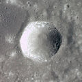
Proclus (crater)
 Apollo 17 image | |
| Coordinates | 16°06′N 46°48′E / 16.1°N 46.8°E |
|---|---|
| Diameter | 27 km |
| Depth | 2.4 km |
| Colongitude | 314° at sunrise |
| Eponym | Proclus |

Proclus is a young lunar impact crater located to the west of the Mare Crisium, on the east shore of the Palus Somni. Its diameter is 27 km. It was named after 5th century Greek mathematician, astronomer and philosopher Proclus.[1]

It lies to the south of the prominent, terraced crater Macrobius, and west-northwest of the lava-flooded Yerkes.
Description[edit]


The rim of Proclus is distinctly polygonal in shape, having the shape of a pentagon, and does not rise very far above the surrounding terrain. It has a high albedo, being second only to Aristarchus in brightness. The interior wall displays some slumping, and the floor is uneven with a few small rises from slump blocks.
The crater has a notable ray system that extends for a distance of over 600 kilometers. The rays display an asymmetry of form, with the most prominent being rays to the northwest, north-northeast, and northeast. There is an arc with no ejecta to the southwest. These features suggest an impact at a low angle. The rays indicate the crater is part of the Copernican System.[2]
A candidate landing site for the Apollo program was located about 100 km north-northeast of Proclus.[2][3] The site was rejected in favor of the geologically diverse Taurus-Littrow valley for the Apollo 17 mission.
Satellite craters[edit]
By convention these features are identified on lunar maps by placing the letter on the side of the crater midpoint that is closest to Proclus.
| Proclus | Latitude | Longitude | Diameter |
|---|---|---|---|
| A | 13.4° N | 42.3° E | 15 km |
| C | 12.9° N | 43.6° E | 10 km |
| D | 17.5° N | 41.0° E | 13 km |
| E | 16.6° N | 40.9° E | 12 km |
| G | 12.7° N | 42.7° E | 33 km |
| J | 17.1° N | 44.0° E | 6 km |
| K | 16.5° N | 46.2° E | 16 km |
| L | 17.1° N | 46.4° E | 9 km |
| M | 16.4° N | 45.2° E | 8 km |
| P | 15.3° N | 48.7° E | 30 km |
| R | 15.8° N | 45.5° E | 28 km |
| S | 15.7° N | 47.9° E | 18 km |
| T | 15.4° N | 46.7° E | 21 km |
| U | 15.2° N | 48.0° E | 13 km |
| V | 14.8° N | 48.3° E | 19 km |
| W | 17.5° N | 46.2° E | 7 km |
| X | 17.7° N | 45.1° E | 6 km |
| Y | 17.5° N | 44.9° E | 8 km |
| Z | 17.9° N | 44.7° E | 6 km |
The following craters have been renamed by the IAU.
- Proclus F — See Crile (crater).
-
 Proclus D
 -
 Proclus G


References[edit]
- ^ "Proclus (crater)". Gazetteer of Planetary Nomenclature. USGS Astrogeology Research Program.
- ^ a b Apollo 15 Preliminary Science Report (NASA SP-289), Chapter 25, Part J, Preliminary geologic map of the region around the candidate Proclus Apollo landing site by Don E. Wilhelms, 1972
- ^ Apollo 15 Preliminary Science Report (NASA SP-289), Chapter 25, Part K, Geologic sketch map of the candidate Proclus Apollo landing site by Baerbel Koesters Lucchitta, 1972
- Andersson, L. E.; Whitaker, E. A. (1982). NASA Catalogue of Lunar Nomenclature. NASA RP-1097.
- Bussey, B.; Spudis, P. (2004). The Clementine Atlas of the Moon. New York: Cambridge University Press. ISBN 978-0-521-81528-4.
- Cocks, Elijah E.; Cocks, Josiah C. (1995). Who's Who on the Moon: A Biographical Dictionary of Lunar Nomenclature. Tudor Publishers. ISBN 978-0-936389-27-1.
- McDowell, Jonathan (July 15, 2007). "Lunar Nomenclature". Jonathan's Space Report. Retrieved 2007-10-24.
- Menzel, D. H.; Minnaert, M.; Levin, B.; Dollfus, A.; Bell, B. (1971). "Report on Lunar Nomenclature by the Working Group of Commission 17 of the IAU". Space Science Reviews. 12 (2): 136–186. Bibcode:1971SSRv...12..136M. doi:10.1007/BF00171763. S2CID 122125855.
- Moore, Patrick (2001). On the Moon. Sterling Publishing Co. ISBN 978-0-304-35469-6.
- Price, Fred W. (1988). The Moon Observer's Handbook. Cambridge University Press. ISBN 978-0-521-33500-3.
- Rükl, Antonín (1990). Atlas of the Moon. Kalmbach Books. ISBN 978-0-913135-17-4.
- Webb, Rev. T. W. (1962). Celestial Objects for Common Telescopes (6th revised ed.). Dover. ISBN 978-0-486-20917-3.
- Whitaker, Ewen A. (1999). Mapping and Naming the Moon. Cambridge University Press. ISBN 978-0-521-62248-6.
- Wlasuk, Peter T. (2000). Observing the Moon. Springer. ISBN 978-1-85233-193-1.
External links[edit]
- LTO-43C3 Proclus, Lunar Topographic Orthophotomap (LTO) Series
- LTO-61B2 Glaisher, Lunar Topographic Orthophotomap (LTO) Series
- Oblique closeup of Proclus crater from Apollo 17 (Figure 147 of Apollo Over the Moon: A View from Orbit (online version) (NASA SP-362), 1978)
- Apollo 17 image AS17-150-23047 using the 70 mm Hasselblad.