
Portal:New South Wales
The New South Wales Portal


New South Wales (commonly abbreviated as NSW) is a state on the east coast of Australia. It borders Queensland to the north, Victoria to the south, and South Australia to the west. Its coast borders the Coral and Tasman Seas to the east. The Australian Capital Territory and Jervis Bay Territory are enclaves within the state. New South Wales' state capital is Sydney, which is also Australia's most populous city. , the population of New South Wales was over 8.3 million, making it Australia's most populous state. Almost two-thirds of the state's population, 5.3 million, live in the Greater Sydney area.
The Colony of New South Wales was founded as a British penal colony in 1788. It originally comprised more than half of the Australian mainland with its western boundary set at 129th meridian east in 1825. The colony then also included the island territories of Van Diemen's Land, Lord Howe Island, and Norfolk Island. During the 19th century, most of the colony's area was detached to form separate British colonies that eventually became the various states and territories of Australia and, arguably, New Zealand. The Swan River Colony (later called the Colony of Western Australia) was never administered as part of New South Wales. (Full article...)
 Recognized content -
-
 The Point Stephens Light is a heritage-listed active lighthouse located on Point Stephens, a point on an unnamed headland at the east of Fingal Bay, 4.25 km (2.64 mi) south of the entrance of Port Stephens, New South Wales, Australia. The light serves to assist vessels entering Port Stephens. It is considered an endangered lighthouse due to remote location and old age.
Proposed in 1857, the heritage-listed lighthouse was built in 1862. Designed by Alexander Dawson, the New South Wales Government Architect at that time, both the lighthouse's flared base and the keeper's cottages combined terrace are unique architectural features for the period. The light source used was originally kerosene lamps, which upgraded in 1912 to a Dalén light, upgraded again to electric light in 1960, automated in 1973, and finally converted to solar power in 1990. In 1991, the last caretaker withdrew from the premises and very soon after the keeper's cottages were vandalised and burned. (Full article...) -
St. John's Orphanage, sometimes referred to as the Goulburn Boys Orphanage, was an orphanage located on Mundy Street in Goulburn, a town located in New South Wales, Australia. The architect of the building was EC Manfred. The foundation stone was laid and blessed on 17 March 1912 by Bishop John Gallagher of Goulburn, who also blessed the building during its opening ceremony in late 1913. It was two storeys high, and several extensions were added to the building throughout its early history. The orphanage amalgamated with St. Joseph's Orphanage for girls in 1976, and the remaining orphans were placed into group homes. As a result, the orphanage was closed in 1978 and rented out to the Youth with a Mission Base until they left in 1994. Since then, the orphanage remained abandoned, until its demolition in 2023.
Run by the Sisters of Mercy and the Catholic Church until its closure, the orphanage housed males from the ages of 5 to 16 initially. Its capacity was intended to be 100 children, but this peaked to more than 200 during the Second World War. By the 1970s, the orphanage began taking in female orphans from St. Joseph's because of declining numbers of males. Until its closure, the orphanage took in more than 2,500 individuals for various reasons. Only four per cent of those who stayed there were actually orphans. The orphanage's residents were given a religious education, and were trained in agriculture. Accounts by former residents state that they suffered severe beatings and punishments, and that they were issued a single set of clothing that was rarely washed. Another claims that some residents endured sexual abuse and rape, not only by the staff, but by older boys, and the caretaker. However, others state that the nuns were tough but fair and remained in contact with them. (Full article...) -
The murder of Leigh Leigh, born Leigh Rennea Mears, occurred on 3 November 1989 while she was attending a 16-year-old boy's birthday party at Stockton Beach, New South Wales, on the east coast of Australia. The 14-year-old girl from Fern Bay was assaulted by a group of boys after she returned distressed from a sexual encounter on the beach that a reviewing judge later called non-consensual. After being kicked and spat on by the group, Leigh left the party. Her naked body was found in the sand dunes nearby the following morning, with severe genital damage and a crushed skull.
Matthew Grant Webster, an 18-year-old who acted as a bouncer at the event, pleaded guilty to her murder and was sentenced to 20 years in prison with a 14-year non-parole period. He was released on parole in June 2004, after serving 14½ years. Guy Charles Wilson, the other bouncer and only other person aged over 18 at the party, pleaded guilty to assault; a third male (aged 15) pleaded guilty to having sex with a minor. The investigation of Leigh's murder proved controversial, however, as several people who admitted to various crimes, including assaulting Leigh, were never charged; nor was anyone ever charged with her sexual assault. Webster's confession did not match the forensic evidence. The murder investigation was reviewed by the New South Wales Crime Commission in 1996, and by the Police Integrity Commission in 1998, with the latter recommending the dismissal of the detective in charge of the investigation. (Full article...) -
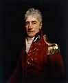
Edward Davis Millen (7 November 1860 – 14 September 1923) was an Australian journalist and politician who served as the first Minister for Repatriation.
Millen emigrated to Australia from England around 1880 and established himself as a journalist, subsequently serving in the New South Wales Legislative Assembly from 1894 to 1898, during which time he fiercely opposed the proposed Federation despite supporting the principle. He was a member of the New South Wales Legislative Council from 1899 until his election to the Australian Senate as a Free Trader from New South Wales at the first federal election in 1901. Millen led the conservative parties in the Senate from 1907 until shortly before his death in 1923. (Full article...) -

Grevillea juniperina, commonly known as juniper- or juniper-leaf grevillea or prickly spider-flower, is a plant of the family Proteaceae native to eastern New South Wales and southeastern Queensland in Australia. Scottish botanist Robert Brown described the species in 1810, and seven subspecies are recognised. One subspecies, G. j. juniperina, is restricted to Western Sydney and environs and is threatened by loss of habitat and housing development.
A small, prickly-leaved shrub between 0.2–3 m (0.66–9.84 ft) high, G. juniperina generally grows on clay-based or alluvial soils in eucalypt woodland. The flower heads, known as inflorescences, appear from winter to early summer and are red, orange or yellow. Birds visit and pollinate the flowers. Grevillea juniperina plants are killed by bushfire, regenerating afterwards from seed. Grevillea juniperina adapts readily to cultivation and has been important in horticulture as it is the parent of many popular garden hybrids. (Full article...) -

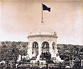
Illawarra Steam Navigation Company's SS Bega at Eden in 1903.
The Illawarra Steam Navigation Company was a shipping company that serviced the south coast of New South Wales, Australia from 1858 to the early 1950s. It was formed through the amalgamation of the General Steam Navigation Company, the Kiama Steam Navigation Company and the Shoalhaven Steam Navigation Company, each of whom serviced parts of the south coast with their respective vessels. After merging, the new company held a near monopoly in regard to shipping on the south coast, and their fleet visited every significant port between Sydney and the border of Victoria. The company transported both passengers and a range of produce, including livestock, and hence it became known as the 'Pig and Whistle Line': it was said that ships would wait an hour for a pig but not a minute for a passenger.
Over the years more than twenty steamships were a part of the fleet, including the 1112-ton Merimbula and the 693-ton Eden. Many of these vessels were purpose-built for the company's needs, and were constructed at shipyards both within Australia and abroad. The company's eventual demise came as a result of a number of factors, including increased competition from road and rail, the cost of replacing ships after World War II, waterfront disputes and rising costs. As a consequence, after almost 100 years in operation, the company was placed into voluntary receivership and was delisted from the stock exchange in 1955. (Full article...) -
Monaro Highway is a 285-kilometre-long (177 mi) highway in Victoria, New South Wales, and the Australian Capital Territory, in Australia, linking Cann River in Victoria to Canberra in the Australian Capital Territory (ACT) via the Monaro region. From its southern terminus, it follows the nearby Cann River upstream towards the New South Wales border through heavily forested terrain. Within New South Wales (NSW), it makes its way through further forest before reaching the pastures typical of the Monaro. There are multiple towns and villages along the highway, including Bombala, Nimmitabel, and Cooma. The terrain within the Monaro is largely hilly, and there are numerous crossings. The road also parallels the former Bombala railway line in several locations. Within the ACT, the road becomes a high volume roadway and serves the southern suburbs of Canberra. The highway has more recently had a grade-separated dual carriageway extension constructed within Canberra, as part of the Eastern Parkway construction project. It is designated part of route M23, and route A23 within Canberra, and route B23 within Victoria and New South Wales, with a concurrency where it also carries route B72 between the two sections of Snowy Mountains Highway. (Full article...) -

The Eastern Suburbs & Illawarra Line (numbered T4, coloured azure blue) is a commuter railway line on the Sydney Trains network in the eastern and southern suburbs of Sydney. The line was constructed in the 1880s to Wollongong to take advantage of agricultural and mining potentials in the Illawarra area. In March 1926, it became the first railway in New South Wales to run electric train services.
Today, the railway consists of three connected lines:- The original Illawarra line from the Sydney CBD to Waterfall
- The Cronulla line from Sutherland to Cronulla, which opened in 1939 replacing an earlier tram service
- The Eastern Suburbs line from the Sydney CBD to Bondi Junction, which opened in 1979
-

The Pacific blue-eye (Pseudomugil signifer) is a species of fish in the subfamily Pseudomugilinae native to eastern Australia. Described by Austrian naturalist Rudolf Kner in 1866, it comprises two subspecies that have been regarded as separate species in the past and may be once again with further study. It is a common fish of rivers and estuaries along the eastern seaboard from Cape York in North Queensland to southern New South Wales, the Burdekin Gap in central-north Queensland dividing the ranges of the two subspecies.
A small silvery fish averaging around 3.25 cm in total length (1+1⁄8–1+3⁄8 in), the Pacific blue-eye is recognisable by its blue eye-ring and two dorsal fins. It forms loose schools of tens to thousands of individuals. It eats water-borne insects as well as flying insects that land on the water's surface, foraging for them by sight. The Pacific blue-eye adapts readily to captivity. (Full article...) -

Persoonia linearis, commonly known as the narrow-leaved geebung, is a shrub native to New South Wales and Victoria in eastern Australia. It reaches 3 m (9.8 ft), or occasionally 5 m (16 ft), in height and has thick, dark grey papery bark. The leaves are, as the species name suggests, more or less linear in shape, and are up to 9 cm (3.5 in) long, and 0.1 to 0.7 cm (0.039 to 0.276 in) wide. The small yellow flowers appear in summer, autumn and early winter (December to July), followed by small green fleshy fruit known as drupes. Within the genus Persoonia, it is a member of the Lanceolata group of 58 closely related species. P. linearis interbreeds with several other species where they grow together.
Found in dry sclerophyll forest on sandstone-based nutrient-deficient soils, P. linearis is adapted to a fire-prone environment; the plants resprout epicormic buds from beneath their thick bark after bushfires. The fruit are consumed by vertebrates such as kangaroo, possums and currawongs. As with other members of the genus, P. linearis is rare in cultivation as it is very hard to propagate by seed or by cuttings, but once propagated, it adapts readily, preferring acidic soils with good drainage and at least a partly sunny aspect. (Full article...) -
Snowy Mountains Highway is a 333-kilometre-long (207 mi) state highway located in New South Wales, Australia. Its two sections connect the New South Wales South Coast to the Monaro region, and the Monaro to the South West Slopes via the Snowy Mountains. The higher altitude regions of this road are subject to snow over the winter months, and the road also provides access to many parts of the Snowy Mountains Scheme. The highway bears the B72 shield along its entire length.
The highway originally bore the name Monaro Highway until 1958, when it received its current name. It originally ran from Tathra to Wagga Wagga but has been shortened to run from Princes Highway to Hume Highway instead. Part of the roadway was reallocated to what is now known as Monaro Highway in 1955. Reservoirs created as a result of dams built in the 1950s and 1960s as part of the Snowy Mountains Scheme required the creation of major realignments to avoid submerged areas. Previous to New South Wales' conversion to alphanumeric route markers, it was signed as National Route 18. (Full article...) -

Alloxylon pinnatum, known as Dorrigo waratah, is a tree of the family Proteaceae found in warm-temperate rainforest of south-east Queensland and northern New South Wales in eastern Australia. It has shiny green leaves that are either pinnate (lobed) and up to 30 cm (12 in) long, or lanceolate (spear-shaped) and up to 15 cm (5.9 in) long. The prominent pinkish-red flower heads, known as inflorescences, appear in spring and summer; these are made up of 50 to 140 individual flowers arranged in corymb or raceme. These are followed by rectangular woody seed pods, which bear two rows of winged seeds.
Known for many years as Oreocallis pinnata, it was transferred to the new genus Alloxylon by Peter Weston and Mike Crisp in 1991. This genus contains the four species previously classified in Oreocallis that are found in Australasia. Its terminal globular flowers indicate that the species is pollinated by birds. Classified as near threatened under the Queensland Nature Conservation Act 1992, the Dorrigo waratah has proven difficult to keep alive in cultivation. (Full article...) -
St John the Baptist Anglican Church is an active Anglican church located between Alt and Bland Streets, Ashfield, a suburb of Sydney, New South Wales, Australia. Founded in 1840, on land donated by Elizabeth Underwood, the church building is the oldest authenticated surviving building in Ashfield, having been built at the time when subdivision increased the population density sufficiently to turn Ashfield into a town. It was also the first church built along the Parramatta Road which linked the early colonial towns of Sydney and Parramatta. The earliest remaining parts of the building are one of the first Sydney designs by the colonial architect Edmund Blacket, who later became renowned for his ecclesiastical architecture.
The expansive church grounds contain a cemetery dating back to 1845 that contains the remains of many notable Ashfield residents. Australia's only memorial to Australian Air Force Cadets occupies a prominent position near the entrance to the church. The St John's site has been listed on the Local Environment Plan Heritage Schedule, and the Register of the National Trust of Australia. (Full article...) -
Banksia ericifolia, the heath-leaved banksia, or lantern banksia, is a species of woody shrub of the family Proteaceae native to Australia. It grows in two separate regions of Central and Northern New South Wales east of the Great Dividing Range. Well known for its orange or red autumn inflorescences, which contrast with its green fine-leaved heath-like foliage, it is a medium to large shrub that can reach 6 m (20 ft) high and wide, though is usually half that size. In exposed heathlands and coastal areas, it is more often 1–2 m (3.3–6.6 ft).
Banksia ericifolia was one of the original Banksia species collected by Joseph Banks around Botany Bay in 1770 and was named by Carl Linnaeus the Younger, son of Carl Linnaeus, in 1782. A distinctive plant, it has split into two subspecies: Banksia ericifolia subspecies ericifolia of the Sydney region and Banksia ericifolia subspecies macrantha of the New South Wales Far North Coast which was recognised in 1996. (Full article...) -
Central Area Command was one of several geographically based commands raised by the Royal Australian Air Force (RAAF) during World War II. It was formed in March 1940, and covered the central portion of New South Wales. Headquartered at Sydney, Central Area Command was responsible for air defence, aerial reconnaissance and protection of the sea lanes within its boundaries. It was disbanded in August 1941 and control of its units taken over by other RAAF formations. Proposals in 1943–44 to raise a new Central Area Command did not come to fruition. (Full article...)


.jpg)

AtEden1903.jpg)


Selected image

The Japanese garden in Cowra is a living reminder of the historic link between the town and the people of Japan, arising from the Cowra breakout by Japanese prisoners of war during World War Two. At five hectares, the Cowra Japanese Garden is the largest Japanese garden in the Southern Hemisphere. An annual Sakura Matsuri (cherry blossom festival) is held in the gardens during late September and/or early October each year.
Related portals

(Northern
Territory) |
WikiProjects
Selected articles -
-

New South Wales (in red)
New South Wales wine is Australian wine produced in New South Wales, Australia. New South Wales is Australia's most populous state and its wine consumption far outpaces the region's wine production. The Hunter Valley, located 130 km (81 mi) north of Sydney, is the most well-known wine region but the majority of the state's production takes place in the Big Rivers zone-Perricoota, Riverina and along the Darling and Murray Rivers. The wines produced from the Big Rivers zone are largely used in box wine and mass-produced wine brands such as Yellow Tail. A large variety of grapes are grown in New South Wales, including Cabernet Sauvignon, Chardonnay, Shiraz and Sémillon.
New South Wales is the second-largest wine-producing state in Australia, accounting for 30 percent of the A$5 billion Australian wine industry In 1994 the various wine regions within New South Wales agreed there was a need to form a peak lobby group to act as the conduit between industry and the New South Wales Government, and to represent New South Wales at the Federal level through the Winemakers Federation of Australia Inc. This body is the New South Wales Wine Industry Association. (Full article...) -
The Harts Buildings is a heritage-listed hotel and pub and former residence, located at 10–14 Essex Street, in the inner city Sydney suburb of The Rocks in the City of Sydney local government area of New South Wales, Australia. It was built from 1890 to 1899. It is also known as Hart's Buildings. The property is owned by Property NSW, an agency of the Government of New South Wales. It was added to the New South Wales State Heritage Register on 10 May 2002. (Full article...) -
The Roxy Community Theatre is a heritage-listed cinema, live theatre, theatre, concert venue and meeting venue located at 114-118 Pine Avenue, Leeton in the Leeton Shire local government area of New South Wales, Australia. It was designed by Kaberry and Chard architects in the Art Deco/Art Nouveau/Spanish Mission style and built from 1929 to 1930 by W. H. Hones for George Conson. It is also known as Roxy Theatre and Big Red. The property is owned by Leeton Shire Council. It was added to the New South Wales State Heritage Register on 24 February 2006. (Full article...) -
Charles Edwin Woodrow Bean (18 November 1879 – 30 August 1968), usually identified as C. E. W. Bean, was a historian and one of Australia's official war correspondents.
He was editor and principal author of the 12-volume Official History of Australia in the War of 1914–1918, and a primary advocate for establishing the Australian War Memorial (AWM).
According to the Online International Encyclopedia of the First World War, no other Australian has been more influential in shaping the way the First World War is remembered in Australia. (Full article...) -
Carlingford (/ˈkɑːrlɪŋfərd/) is a suburb of Sydney, in the state of New South Wales, Australia. Carlingford is 22 kilometres north-west of the Sydney central business district in the local government area of City of Parramatta. Carlingford sits at the meeting point of Northern Sydney and Western Sydney sitting on both sides of Pennant Hills Road which generally acts as a divider of the two regions. While being part of City of Parramatta, it is sometimes referred to as being part of the Hills District. (Full article...) -
The Rolex Sydney Hobart Yacht Race is an annual event hosted by the Cruising Yacht Club of Australia, starting in Sydney, New South Wales, on Boxing Day and finishing in Hobart, Tasmania. The race distance is approximately 630 nautical miles (1,170 km). The race is run in conjunction with the Royal Yacht Club of Tasmania, and is widely considered to be one of the most difficult yacht races in the world.
The race was initially planned to be a cruise by Peter Luke and some friends who had formed a club for those who enjoyed cruising as opposed to racing; however, when a visiting British Royal Navy Officer, Captain John Illingworth, suggested it be made a race, the event was born. Since the inaugural race in 1945, the Sydney to Hobart Yacht Race has grown over the decades to become one of the top three offshore yacht races in the world, and it now attracts maxi yachts from all around the globe. The 2019 race was the 75th edition. (Full article...) -

Map of rail lines in NSW
The Australian state of New South Wales has an extensive network of railways, which were integral to the growth and development of the state. The vast majority of railway lines were government built and operated, but there were also several private railways, some of which operate to this day. (Full article...) -
The Darling River (Paakantyi: Baaka or Barka) is the third-longest river in Australia, measuring 1,472 kilometres (915 mi) from its source in northern New South Wales to its confluence with the Murray River at Wentworth. Including its longest contiguous tributaries it is 2,844 km (1,767 mi) long, making it the longest river system in Australia. The Darling River is the outback's most famous waterway.
The Darling is in poor health, suffering from over-allocation of its waters to irrigation, pollution from pesticide runoff, and prolonged drought. During drought periods in 2019 it barely flowed at all. The river has a high salt content and declining water quality. Increased rainfall in its catchment in 2010 improved its flow, but the health of the river will depend on long-term management. (Full article...) -

Geoffrey Lee (born c. 1967) is a former Australian politician. He served as the Minister for Corrections in the second Perrottet ministry between December 2021 and March 2023. He has previously served as the Minister for Skills and Tertiary Education in the second Berejiklian and Perrottet ministries between April 2019 and December 2021. Lee was also a member of the New South Wales Legislative Assembly representing Parramatta for the Liberal Party since 2011 until his retirement in 2023. (Full article...) -
The Supreme Court of New South Wales is the highest state court of the Australian State of New South Wales. It has unlimited jurisdiction within the state in civil matters, and hears the most serious criminal matters. Whilst the Supreme Court is the highest New South Wales court in the Australian court hierarchy, an appeal by special leave can be made to the High Court of Australia.
Matters of appeal can be submitted to the New South Wales Court of Appeal and Court of Criminal Appeal, both of which are constituted by members of the Supreme Court, in the case of the Court of Appeal from those who have been commissioned as judges of appeal. (Full article...) -
Mungo National Park is a protected national park that is located in south-western New South Wales, in eastern Australia. The 110,967-hectare (274,210-acre) national park is situated approximately 875 kilometres (544 mi) west of Sydney in the Balranald Shire. Mungo National Park is the traditional meeting place of the Muthi Muthi, Nyiampaar and Barkinji Aboriginal Nations. People are no longer able to climb the sand dunes by themselves as stricter rules have been enforced, all visitors groups need to be accompanied by an accredited tour guide to access the sand dunes.
The national park is part of the UNESCO World Heritage–listed Willandra Lakes Region, an area of 2,400 square kilometres (930 sq mi) that incorporates seventeen dry lakes. The seventeen dry lakes are not all called Mungo but are all declared world heritage. The creek that used to flow into Mungo is being preserved as a sacred site. The national park is about 75 kilometres (47 mi) south-east of Pooncarie, 110 kilometres (68 mi) north-east of Mildura and approximately 145 kilometres (90 mi), 90 minutes drive south-west of Ivanhoe. The roads to, in or around the park are unsealed and can be accessed in 2-wheel-drive cars, but councils will close the road in wet weather. (Full article...) -
Wodonga (pronounced /wəˈdɒŋɡə/; Pallanganmiddang: Wordonga) is a city on the Victorian side of the border with New South Wales, 324 kilometres (201 mi) north-east of Melbourne, Australia. It is part of the twin city of Albury-Wodonga and is located wholly within the boundaries of the City of Wodonga LGA and is separated from its twin city in New South Wales, Albury, by the Murray River. As of 2021 Wodonga and its suburbs have a population of 38,949 and combined with Albury, the two cities form the urban area Albury-Wodonga with a population of 97,793. There are multiple suburbs of Wodonga including Bandiana, Baranduda, Barnawartha, Bonegilla, Ebden, Huon Creek, Killara, Leneva and Staghorn.
Wodonga produces a gross domestic product of $2.5 billion per year on average. (Full article...) -
The Montreal Community Theatre is a heritage-listed cinema and community theatre at 46 Russell Street, Tumut, Snowy Valleys Council, New South Wales, Australia. It was designed by Kaberry & Chard and built from 1929 to 1930. It is also known as Montreal Community Theatre and Moveable Heritage Collection. The property is owned by the Snowy Valleys Council. It was added to the New South Wales State Heritage Register on 21 June 2013. (Full article...) -
The Parliament of New South Wales, formally the Legislature of New South Wales, is the bicameral legislative body of the Australian state of New South Wales (NSW). It consists of the monarch, the New South Wales Legislative Assembly (lower house) and the New South Wales Legislative Council (upper house). Each house is directly elected by the people of New South Wales at elections held approximately every four years. The legislative authority of the parliament derives from section 5 of the Constitution Act 1902 (NSW). The power to make laws that apply to New South Wales is shared with the Federal (or Commonwealth) Parliament. The houses of the New South Wales Parliament follow the Westminster parliamentary traditions of dress, Green–Red chamber colours and protocols. The houses of the legislature are located in Parliament House on Macquarie Street, Sydney. (Full article...) -
Nimbin is a town in the Northern Rivers area of the Australian state of New South Wales, approximately 30 km (19 mi) north of Lismore, 33 km (21 mi) northeast of Kyogle, and 70 km (43 mi) west of Byron Bay.
Nimbin is notable for the prominence of its environmental initiatives such as permaculture, sustainability, and self-sufficiency, as well as the cannabis counterculture. Writer Austin Pick described his initial impressions of the village this way: "It is as if a smoky avenue of Amsterdam has been placed in the middle of the mountains behind frontier-style building facades. ... Nimbin is a strange place indeed." (Full article...)


.jpg)


.jpg)


Did you know (auto-generated)

- ... that Victorian post office official William Rundell also collected stamps in his spare time, acquiring 48 copies of the "Sydney view" stamps of New South Wales?
- ... that Turkish international soccer player Rojin Polat was named member of the "2021 All Schools Merit Girls Team" in New South Wales, Australia?
- ... that the "Cuddle with a Koala" experience at Featherdale Wildlife Park was stopped in 1988 when New South Wales law was changed to restrict koala handling?
General images -
-
 Aboriginal tribes in New South Wales, from an 1892 map (from History of New South Wales)
 -
 Dry paddocks in the Riverina region during the 2007 drought (from History of New South Wales)
 -
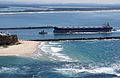 A bulk carrier entering the Port of Newcastle, New South Wales, 2009 (from Economy of New South Wales)
 -

-
 Early expeditions of Charles Sturt (from History of New South Wales)
 -
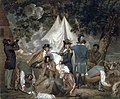 Founding of the settlement of Port Jackson at Botany Bay in New South Wales in 1788 - Thomas Gosse (from History of New South Wales)
 -
 Humanitarian Caroline Chisholm provided support to poverty-stricken women migrants (from History of New South Wales)
 -

-
 Mr E.H. Hargraves, The Gold Discoverer of Australia, returning the salute of the gold miners - Thomas Tyrwhitt Balcombe, 1851 (from History of New South Wales)
 -
 A chart of part of the interior of New South Wales by John Oxley, Surveyor General, 1822 (from History of New South Wales)
 -
 Bondi Beach circa 1900 (from History of New South Wales)
 -
 Olympic colours on the Sydney Harbour Bridge in the year 2000 (from History of New South Wales)
 -
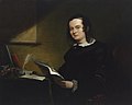
 William Wentworth was key in the establishment of self-governance in New South Wales (from History of New South Wales)
 -
 Hyde Park, Sydney with the Australian Museum under construction in the distance, 1842 (from History of New South Wales)
 -
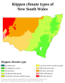 Köppen climate types in New South Wales (from Geography of New South Wales)
 -
 Landing of Lieutenant James Cook at Botany Bay, 29 April 1770 (from History of New South Wales)
 -
 Tumut 3 Power Station was constructed as part of the vast Snowy Mountains Scheme in New South Wales (1949–1974). Construction necessitated the expansion of Australia's immigration program. (from History of New South Wales)
 -
 The 5th Governor of New South Wales, Lachlan Macquarie, was influential in establishing civil society in Australia (from History of New South Wales)
 -
 Murray Grey cows and calves (from Economy of New South Wales)
 -

-
 The Sydney Opera House was opened in 1973. (from History of New South Wales)
 -
 Federation Pavilion, Centennial Park, Sydney, 1 January 1901. (from History of New South Wales)
 -
 Ribbon ceremony to open the Sydney Harbour Bridge on 20 March 1932. Breaking protocol, the soon to be dismissed Premier Jack Lang cuts the ribbon while Governor Philip Game looks on. (from History of New South Wales)
 -
 Governor Arthur Phillip hoists the British flag over the new colony at Sydney in 1788 (from History of New South Wales)
 -
 World leaders with Prime Minister John Howard in Sydney for the 2007 APEC conference (from History of New South Wales)
 -
 A 630 lb gold specimen from Hill End, unearthed in 1872 (from History of New South Wales)
 -
 A General Chart of New Holland including New South Wales & Botany Bay with The Adjacent Countries and New Discovered Lands, published in An Historical Narrative of the Discovery of New Holland and New South Wales, London, Fielding and Stockdale, November 1786 (from History of New South Wales)

.jpg)


.jpg)


.jpg)


Topics
Categories

More portals
In the news
- 10 June 2024 – Israel–Hamas war
- The United States Consulate General in Sydney, Australia, is vandalized by a pro-Palestinian activist. (NBC News)
Associated Wikimedia
The following Wikimedia Foundation sister projects provide more on this subject:
-
 Commons
Free media repository -
 Wikibooks
Free textbooks and manuals -
 Wikidata
Free knowledge base -
 Wikinews
Free-content news -
 Wikiquote
Collection of quotations -
 Wikisource
Free-content library -
 Wikiversity
Free learning tools -
 Wikivoyage
Free travel guide -
 Wiktionary
Dictionary and thesaurus


