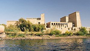
Agilkia Island

Agilkia Island (also called Agilika; Arabic: أجيليكا, from Old Nubian: ⲁ̅ⲅⲗ̅, romanised: agil, "mouth"[1]) is an island in the reservoir of the Old Aswan Dam along the Nile River in southern Egypt; it is the present site of the relocated ancient Egyptian temple complex of Philae. Partially to completely flooded by the old dam's construction in 1902,[2][3] the Philae complex was dismantled and relocated to Agilkia island, as part of a wider UNESCO project[4] related to the 1960s construction of the Aswan High Dam and the eventual flooding of many sites posed by its large reservoir upstream.[5][6]
Agilkia, like the island, was the name chosen for the planned landing site on a comet by the Rosetta spacecraft mission's Philae lander.[7][8] Upon initial touchdown, however, the lander took a large bounce followed by a smaller one before finally coming to rest perhaps a kilometre away from Agilkia, at a site named Abydos, after the ancient Egyptian city.
References
[edit]- ^ Browne, Gerald M. (1996). Old Nubian Dictionary. University of Virginia: In Aedibus Peeters. p. 4.
- ^ Frederic Courtland Penfield, Harnessing the Nile, Century Magazine, (February, 1899)
- ^ Sidney Peel, The Binding of the Nile and the New Soudan, Oxford 1904 , p.76
- ^ Monuments of Nubia-International Campaign to Save the Monuments of Nubia World Heritage Committee, UNESCO
- ^ The Rescue of Nubian Monuments and Sites, UNESCO
- ^ Murray, Tim (2007). Milestones in Archaeology: a Chronological Encyclopedia. ABC-CLIO. p. 464. ISBN 978-1-57607-186-1.
- ^ Platt, Jane (6 November 2014). "Rosetta Races Toward Comet Touchdown". NASA. Retrieved 7 November 2014.
- ^ Knapton, Sarah (4 November 2014). "Historic Comet Landing Site Has a New Name: Agilkia". The Daily Telegraph. Archived from the original on 4 November 2014. Retrieved 4 November 2014.
External links
[edit]- Griffith, F.L. (1911). . Encyclopædia Britannica. Vol. 21 (11th ed.). p. 373.
- Sacred Temple Island of Philae
- Philae @ The Domain of Het-Hert another alternative name for Hathor - aerial view of the temples
- Philae @ Akhet Egyptology

