
Portal:Kent/Sandbox
DesktopMobile
Test of: Transclude files as random slideshow/sandbox
-
 An early mention of Kent in the Anglo-Saxon Chronicle between 11th and 12th centuries (from Kent)
 -
 View of the White Cliffs of Dover from France (from Kent)
 -
-
 The coat of arms of Kent County Council (from Kent)
 -
 Geological cross-section of Kent, showing how it relates to major towns (from Kent)
 -

-
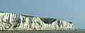 The White Cliffs of Dover (from Kent)
 -
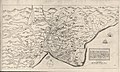
 Hand-drawn map of Kent, Sussex, Surrey and Middlesex from 1575. (from Kent)
 -

-

-
 A map of Romney Marsh "The history of imbanking and drayning" by William Dugdale (1662). (from Kent)
 -
 Canterbury Cathedral (from Kent)
 -
-
-
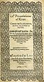 Title page of William Lambarde's Perambulation of Kent (completed in 1570 and published in 1576), a historical description of Kent and the first published county history (from Kent)

Apr2006.jpg)


.jpg)


Test of: Transclude linked excerpts as random slideshow/sandbox
-
 Sir William Turner Walton OM (29 March 1902 – 8 March 1983) was an English composer. During a sixty-year career, he wrote music in several classical genres and styles, from film scores to opera. His best-known works include Façade, the cantata Belshazzar's Feast, the Viola Concerto, the First Symphony, and the British coronation marches Crown Imperial and Orb and Sceptre. (Full article...)
 -
Gillingham Football Club is a professional association football club based in the town of Gillingham, Kent, England. The only Kent-based club in the Football League, the "Gills" play their home matches at Priestfield Stadium. The team competes in League Two, the fourth tier of the English football league system, in the 2023–24 season. (Full article...)
-
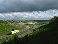
The M20 is a motorway in Kent, England. It follows on from the A20 at Swanley, meeting the M25, and continuing on to Folkestone, providing a link to the Channel Tunnel and the ports at Dover. It is 50.6 miles (81.4 km) long. Although not signposted in England, this road is part of the European route E15. It is also used as a holding area for goods traffic when traffic across the English Channel is disrupted, such as Operation Stack and Operation Brock. (Full article...)
-
The ceremonial county of Kent, (which includes the unitary authority of Medway), is divided into 17 parliamentary constituencies - one borough constituency and 16 county constituencies. (Full article...)
-
Leonard Constant Lambert (23 August 1905 – 21 August 1951) was a British composer, conductor, and author. He was the founder and music director of the Royal Ballet, and (alongside Dame Ninette de Valois and Sir Frederick Ashton) he was a major figure in the establishment of the English ballet as a significant artistic movement. (Full article...)
-
The Battle of Britain (German: Luftschlacht um England, "air battle for England") was a military campaign of the Second World War, in which the Royal Air Force (RAF) and the Fleet Air Arm (FAA) of the Royal Navy defended the United Kingdom (UK) against large-scale attacks by Nazi Germany's air force, the Luftwaffe. It was the first major military campaign fought entirely by air forces. The British officially recognise the battle's duration as being from 10 July until 31 October 1940, which overlaps the period of large-scale night attacks known as the Blitz, that lasted from 7 September 1940 to 11 May 1941. German historians do not follow this subdivision and regard the battle as a single campaign lasting from July 1940 to May 1941, including the Blitz. (Full article...)
-
The Dungeness nuclear power stations are a pair of non-operational nuclear power stations located on the Dungeness headland in the south of Kent, England. (Full article...)
-
A watermill or water mill is a mill that uses hydropower. It is a structure that uses a water wheel or water turbine to drive a mechanical process such as milling (grinding), rolling, or hammering. Such processes are needed in the production of many material goods, including flour, lumber, paper, textiles, and many metal products. These watermills may comprise gristmills, sawmills, paper mills, textile mills, hammermills, trip hammering mills, rolling mills, wire drawing mills. (Full article...)
-
Hampshire (/ˈhæmpʃər/, /-ʃɪər/ ; abbreviated to Hants.) is a ceremonial county in South East England. It is bordered by Berkshire to the north, Surrey and West Sussex to the east, the Isle of Wight across the Solent to the south, Dorset to the west, and Wiltshire to the north-west. The cities of Portsmouth and Southampton are the largest settlements and the county town is the city of Winchester. (Full article...)
-
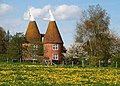
An oast, oast house or hop kiln is a building designed for kilning (drying) hops as part of the brewing process. They can be found in most hop-growing (and former hop-growing) areas and are often good examples of vernacular architecture. Many redundant oasts have been converted into houses. The names oast and oast house are used interchangeably in Kent and Sussex. In Surrey, Hampshire, Herefordshire and Worcestershire they are called hop kilns. (Full article...)
-
Sheerness (/ʃɪərˈnɛs/) is a port town and civil parish beside the mouth of the River Medway on the north-west corner of the Isle of Sheppey in north Kent, England. With a population of 11,938, it is the second largest town on the island after the nearby town of Minster which has a population of 21,319. (Full article...)
-
The University of Kent (formerly the University of Kent at Canterbury, abbreviated as UKC) is a semi-collegiate public research university based in Kent, United Kingdom. The university was granted its royal charter on 4 January 1965 and the following year Princess Marina, Duchess of Kent, was formally installed as the first Chancellor. (Full article...)
-
Clay is a type of fine-grained natural soil material containing clay minerals (hydrous aluminium phyllosilicates, e.g. kaolinite, Al2Si2O5(OH)4). Most pure clay minerals are white or light-coloured, but natural clays show a variety of colours from impurities, such as a reddish or brownish colour from small amounts of iron oxide. (Full article...)
-
Upnor Castle is an Elizabethan artillery fort located on the west bank of the River Medway in Kent. It is in the village of Upnor, opposite and a short distance downriver from the Chatham Dockyard, at one time a key naval facility. The fort was intended to protect both the dockyard and ships of the Royal Navy anchored in the Medway. It was constructed between 1559 and 1567 on the orders of Elizabeth I, during a period of tension with Spain and other European powers. The castle consists of a two-storeyed main building protected by a curtain wall and towers, with a triangular gun platform projecting into the river. It was garrisoned by about 80 men with a peak armament of around 20 cannon of various calibres. (Full article...)
-
Folkestone (/ˈfəʊkstən/ FOHK-stən) is a port town on the English Channel, in Kent, south-east England. The town lies on the southern edge of the North Downs at a valley between two cliffs. It was an important harbour, shipping port and fashionable coastal resort for most part of the 19th and mid 20th centuries. (Full article...)
-
The Port of Dover is a cross-channel ferry, cruise terminal, maritime cargo and marina facility situated in Dover, Kent, south-east England. It is the nearest English port to France, at just 34 kilometres (21 mi) away, and is one of the world's busiest maritime passenger ports, with 11.7 million passengers, 2.6 million lorries, 2.2 million cars and motorcycles and 80,000 coaches passing through it in 2017, and with an annual turnover of £58.5 million a year. This contrasts with the nearby Channel Tunnel, the only fixed link between the island of Great Britain and the European mainland, which now handles an estimated 20 million passengers and 1.6 million trucks per year. (Full article...)
-
Allington is an almost entirely modern village situated alongside the sides of the A20 road west of Maidstone in Kent, England. It is part of the built-up area of Maidstone. (Full article...)
-
Kent Police is the territorial police force responsible for policing the 1,433 sq mi (3,710 km2) and approximately 1.8 million inhabitants of Kent, a county in South East England. (Full article...)
-
Chatham (/ˈtʃætəm/ CHAT-əm) is a town located within the Medway unitary authority in the ceremonial county of Kent, England. The town forms a conurbation with neighbouring towns Gillingham, Rochester, Strood and Rainham. In 2020 it had a population of 80,596. (Full article...)
-
Cliffe is a village and former civil parish, now in the parish of Cliffe and Cliffe Woods, in the borough of Medway in the ceremonial county of Kent, England. It is on the Hoo Peninsula, reached from the Medway Towns by a three-mile (4.8 km) journey along the B2000 road. Situated upon a low chalk escarpment overlooking the Thames marshes, Cliffe offers views of Southend-on-Sea and London. In 774 Offa, King of Mercia, built a rustic wooden church dedicated to St Helen, a popular Mercian saint who was by legend the daughter of Coel ("Old King Cole") of Colchester. Cliffe is cited in early records as having been called Clive and Cliffe-at-Hoo. In 1961 the parish had a population of 2239. On 1 April 1997 the parish was abolished to form "Cliffe & Cliiffe Woods", part also went to and Frindsbury Extra. (Full article...)
-
Leas Cliff Hall is an entertainment and function venue situated in Folkestone, on the Kent coast of England. The Grand Hall seats 900 and it has a standing capacity of 1500. It currently presents a varied programme of touring shows including concerts, comedy, ballet and wrestling. (Full article...)
-
Westerham is a town and civil parish in the Sevenoaks District of Kent, England. It is located 3.4 miles east of Oxted and 6 miles west of Sevenoaks, adjacent to the Kent border with both Greater London and Surrey.
It is recorded as early as the 9th century, and was mentioned in the Domesday Book in a Norman form, Oistreham (compare Ouistreham in Normandy, Oistreham in 1086). Hām is Old English for a village or homestead, and so Westerham means a westerly homestead. The River Darent flows through the town, and formerly powered three watermills. (Full article...) -
Air charter is the business of renting an entire aircraft (i.e., chartering) as opposed to individual aircraft seats (i.e., purchasing a ticket through a traditional airline). (Full article...)
-
Local government in the United Kingdom has origins that pre-date the United Kingdom itself, as each of the four countries of the United Kingdom has its own separate system. For an overview, see Administrative geography of the United Kingdom. For details, see: (Full article...)
-
East Sussex is a ceremonial county in South East England. It is bordered by Kent to the north-east, West Sussex to the west, Surrey to the north-west, and the English Channel to the south. The largest settlement is the city of Brighton and Hove, and the county town is Lewes. (Full article...)
