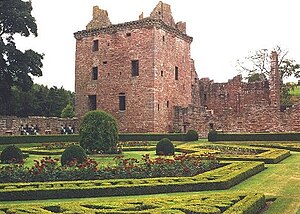
Edzell Castle and gardensEdzell Castle is a ruined 16th-century castle, with an early-17th-century walled garden. It is located close to Edzell, and is around 5 miles (8 km) north of Brechin, in Angus, Scotland. Edzell Castle was begun around 1520 by David Lindsay, 9th Earl of Crawford, and expanded by his son, Sir David Lindsay, Lord Edzell, who also laid out the garden in 1604. The castle saw little military action, and was, in its design, construction and use, more of a country house than a defensive structure. It was briefly occupied by English troops during Oliver Cromwell's invasion of Scotland in 1651. In 1715 it was sold by the Lindsay family, and eventually came into the ownership of the Earl of Dalhousie. It was given into state care in the 1930s, and is now a visitor attraction run by Historic Environment Scotland (open all year; entrance charge). The castle consists of the original tower house and building ranges around a courtyard. The adjacent Renaissance walled garden, incorporating intricate relief carvings, is unique in Scotland. It was replanted in the 1930s, and is considered to have links to esoteric traditions, including Rosicrucianism and Freemasonry. (Full article...) Read more ... ()
Charles landed in Scotland in July 1745, seeking to restore his father James Francis Edward Stuart to the British throne. He quickly won control of large parts of Scotland, and an invasion of England reached as far south as Derby before being forced to turn back. However, by April 1746, the Jacobites were short of supplies, facing a superior and better equipped opponent.
Charles and his senior officers decided their only option was to stand and fight. When the two armies met at Culloden, the battle lasted less than an hour, with the Jacobites suffering a bloody defeat. This ended both the 1745 rising, and Jacobitism as a significant element in British politics. (Full article...) Read more ... ()
The estate and its original castle were bought from the Farquharson family in 1852 by Prince Albert, the husband of Queen Victoria. Soon afterwards the house was found to be too small and the current Balmoral Castle was commissioned. The architect was William Smith of Aberdeen, and his designs were amended by Prince Albert. Balmoral remains the private property of the monarch and is not part of the Crown Estate. It was the summer residence of Queen Elizabeth II, who died there on 8 September 2022.
The Balmoral Estate has been added to by successive members of the royal family, and now covers an area of 21,725 hectares (53,684 acres) of land. It is a working estate, including grouse moors, forestry and farmland, as well as managed herds of deer, Highland cattle, sheep and ponies. (Full article...) Read more ... ()
Aerial view of Stirling CastleStirling Castle, located in Stirling, is one of the largest and most historically and architecturally important castles in Scotland. The castle sits atop an intrusivecrag, which forms part of the Stirling Sill geological formation. It is surrounded on three sides by steep cliffs, giving it a strong defensive position. Its strategic location, guarding what was, until the 1890s, the farthest downstream crossing of the River Forth, has made it an important fortification in the region from the earliest times.
Most of the principal buildings of the castle date from the fifteenth and sixteenth centuries. A few structures remain from the fourteenth century, while the outer defences fronting the town date from the early eighteenth century.
Before the union with England, Stirling Castle was also one of the most used of the many Scottish royal residences, very much a palace as well as a fortress. Several Scottish Kings and Queens have been crowned at Stirling, including Mary, Queen of Scots, in 1542, and others were born or died there.
Loch Leven Castle from the FerryLochleven Castle is a ruined castle on an island in Loch Leven, in the Perth and Kinross local authority area of Scotland. Possibly built around 1300, the castle was the site of military action during the Wars of Scottish Independence (1296–1357). In the latter part of the 14th century, the castle was granted to William Douglas, 1st Earl of Douglas, by his uncle. It remained in the Douglases' hands for the next 300 years. Mary, Queen of Scots, was imprisoned there in 1567–68, and forced to abdicate as queen, before escaping with the help of her gaoler's family. In 1588, the queen's gaoler inherited the title of Earl of Morton, and moved away from the castle. In 1675, Sir William Bruce, an architect, bought the castle and used it as a focal point for his garden; it was never again used as a residence.
The remains of the castle are protected as a scheduled monument in the care of Historic Environment Scotland. Lochleven Castle is open to the public in summer, and access is available by ferry. (Full article...) Read more ... ()
Covering 875.35 square kilometres (337.97 sq mi), Mull is the fourth-largest island in Scotland and Great Britain. From 2001 to 2020, the population has gradually increased: during 2020 it was estimated to be 3,000, in the 2011 census it was about 2,800, and in 2001, it was measured at 2,667 people. It has the eighth largest island population in Scotland. In the summer, these numbers are augmented by an influx of many tourists. Much of the year-round population lives in the colourful main settlement of Tobermory.
There are two distilleries on the island: the Tobermory distillery, formerly named Ledaig, produces single malt Scotch whisky and another, opened in 2019 and located in the vicinity of Tiroran, which produces Whitetail Gin. Mull is host to numerous sports competitions, notably the Highland Games competition, held annually in July. The isle is home to four castles, including the towering castle of Duart and the keep of Moy Castle. On the south coast, a stone circle is located in the settlement of Lochbuie. (Full article...) Read more ... ()
Image 12
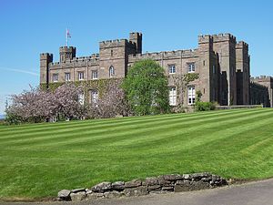
Scone Palace, south facadeScone Palace/ˈskuːn/ is a Category A-listedhistoric house near the village of Scone and the city of Perth, Scotland. Ancestral seat of Earls of Mansfield, built in red sandstone with a castellated roof, it is an example of the Gothic Revival style in Scotland.
Scone was originally the site of an early Christian church, and later an Augustinian priory. Scone Abbey was severely damaged in 1559 during the Scottish Reformation after a mob whipped up by the famous reformer, John Knox, came to Scone from Dundee. Having survived the Reformation, the Abbey in 1600 became a secular Lordship (and home) within the parish of Scone, Scotland. The Palace has thus been home to the Earls of Mansfield for over 400 years. During the early 19th century the Palace was enlarged by the architect William Atkinson. In 1802, David William Murray, 3rd Earl of Mansfield, commissioned Atkinson to extend the Palace, recasting the late 16th-century Palace of Scone. The 3rd Earl tasked Atkinson with updating the old Palace whilst maintaining characteristics of the medieval Gothic abbey buildings it was built upon, with the majority of work finished by 1807. (Full article...) Read more ... ()
There is evidence of Iron Age settlement, but its history as a town began with the founding of Arbroath Abbey in 1178. It grew much during the Industrial Revolution through the flax and then the jute industry and the engineering sector. A new harbour was created in 1839; by the 20th century, Arbroath was one of Scotland's larger fishing ports.
The modern Scottish kilt worn with formal evening wearA kilt (Scottish Gaelic: fèileadh[ˈfeːləɣ]) is a garment resembling a wrap-around knee-length skirt, made of twill-woven worstedwool with heavy pleats at the sides and back and traditionally a tartan pattern. Originating in the Scottish Highland dress for men, it is first recorded in the 16th century as the great kilt, a full-length garment whose upper half could be worn as a cloak. The small kilt or modern kilt emerged in the 18th century, and is essentially the bottom half of the great kilt. Since the 19th century, it has become associated with the wider culture of Scotland, and more broadly with Gaelic or Celtic heritage.
Although the kilt is most often worn by men on formal occasions and at Highland games and other sports events, it has also been adapted as an item of informal male clothing, returning to its roots as an everyday garment. Kilts are now made for casual wear in a variety of materials. Alternative fastenings may be used and pockets inserted to avoid the need for a sporran. Kilts have also been adopted as female wear for some sports. (Full article...) Read more ... ()
Craigmillar Castle from the eastCraigmillar Castle is a ruined medieval castle in Edinburgh, Scotland. It is three miles (4.8 km) south-east of the city centre, on a low hill to the south of the modern suburb of Craigmillar. The Preston family of Craigmillar, the local feudal barons, began building the castle in the late 14th century and building works continued through the 15th and 16th centuries. In 1660, the castle was sold to Sir John Gilmour, Lord President of the Court of Session, who breathed new life into the ageing castle. The Gilmours left Craigmillar in the 18th century for a more modern residence, nearby Inch House, and the castle fell into ruin. It is now in the care of Historic Environment Scotland as a scheduled monument, and is open to the public.
Craigmillar Castle is best known for its association with Mary, Queen of Scots. Following an illness after the birth of her son, the future James VI, Mary arrived at Craigmillar on 20 November 1566 to convalesce. Before she left on 7 December 1566, a pact known as the "Craigmillar Bond" was made, with or without her knowledge, to dispose of her husband Henry Stuart, Lord Darnley. (Full article...) Read more ... ()
Loch Lomond, looking south from Ben LomondLoch Lomond (/ˈlɒxˈloʊmənd/; Scottish Gaelic: Loch Laomainn) is a freshwater Scottish loch which crosses the Highland Boundary Fault, often considered the boundary between the lowlands of Central Scotland and the Highlands. Traditionally forming part of the boundary between the counties of Stirlingshire and Dunbartonshire, Loch Lomond is split between the council areas of Stirling, Argyll and Bute and West Dunbartonshire. Its southern shores are about 23 kilometres (14 mi) northwest of the centre of Glasgow, Scotland's largest city. The Loch forms part of the Loch Lomond and The Trossachs National Park which was established in 2002.
Loch Lomond is 36.4 kilometres (22.6 mi) long and between 1 and 8 kilometres (0.62–4.97 mi) wide, with a surface area of 71 km2 (27.5 sq mi). It is the largest lake in Great Britain by surface area; in the United Kingdom, it is surpassed only by Lough Neagh and Lough Erne in Northern Ireland. In the British Isles as a whole there are several larger loughs in the Republic of Ireland. The loch has a maximum depth of about 190 metres (620 ft) in the deeper northern portion, although the southern part of the loch rarely exceeds 30 metres (98 ft) in depth. The total volume of Loch Lomond is 2.6 km3 (0.62 cu mi), making it the second largest lake in Great Britain, after Loch Ness, by water volume. (Full article...) Read more ... ()
Notable figures from the Roman period in Scottish history as depicted by the Victorian artist William Hole Scotland during the Roman Empire refers to the protohistorical period during which the Roman Empire interacted within the area of modern Scotland. Despite sporadic attempts at conquest and government between the first and fourth centuries AD, most of modern Scotland, inhabited by the Caledonians and the Maeatae, was not incorporated into the Roman Empire with Roman control over the area fluctuating.
In the Roman imperial period, the area of Caledonia lay north of the River Forth, while the area now called England was known as Britannia, the name also given to the Roman province roughly consisting of modern England and Wales and which replaced the earlier Ancient Greek designation as Albion. Roman legions arrived in the territory of modern Scotland around AD 71, having conquered the Celtic Britons of southern Britannia over the preceding three decades. Aiming to complete the Roman conquest of Britannia, the Roman armies under Quintus Petillius Cerialis and Gnaeus Julius Agricola campaigned against the Caledonians in the 70s and 80s. The Agricola, a biography of the Roman governor of Britannia by his son-in-law Tacitus mentions a Roman victory at "Mons Graupius" which became the namesake of the Grampian Mountains but whose identity has been questioned by modern scholarship. In 2023 a lost Roman road built by Julius Agricola was rediscovered in Drip close to Stirling: it has been described as "the most important road in Scottish history." (Full article...) Read more ... ()
" ... A custom loathsome to the eye, hateful to the nose, harmful to the brain, dangerous to the lungs, and in the black, stinking fume thereof, nearest resembling the horrible Stygian smoke of the pit that is bottomless ... "
" ... When shall I see Scotland again? Never shall I forget the happy days I passed there amidst odious smells, barbarous sounds, bad suppers, excellent hearts and the most enlightened and cultivated understandings ... "
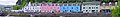
Image 2The Royal Burgh of Haddington is a town in East Lothian. It is the main administrative, cultural and geographical centre for East Lothian, which was known officially as Haddingtonshire before 1921. It lies approximately 20 miles (32 km) east of Edinburgh.
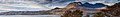
Image 3Suilven (Scottish Gaelic: Sula Bheinn) is one of the most distinctive mountains in Scotland. Lying in a remote area in the west of Sutherland, it rises almost vertically from a wilderness landscape of moorland, bogs and lochans known as Inverpolly National Nature Reserve. The mountain forms a steep-sided ridge some 2 km in length. The highest point, known as Caisteal Liath (meaning "the Grey Castle"), lies at the northwest end of this ridge.
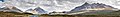
Image 4The River Tweed, or Tweed Water, (Scottish Gaelic: Abhainn Thuaidh) is 97 miles (156 km) long and flows primarily through the Borders. It rises on Tweedsmuir at Tweed's Well near where the Clyde, draining northwest, and the Annan draining south also rise.
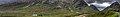
Image 5Loch Leven (Scottish Gaelic: Loch Lìobhann) is a sea loch on the west coast of Scotland. Loch Leven extends 8¾ miles (14 km), varying in width between 220 yards (200 m) and just over a mile (1.8 km). It opens onto Camus a'Chois at North Ballachulish, part of Loch Linnhe at its western end.
Image 6The Forth Bridge is a cantileverrailwaybridge over the Firth of Forth. It was opened on 4 March 1890, and spans a total length of 2,528.7 metres (8,296 ft). It is often called the Forth Rail Bridge or Forth Railway Bridge to distinguish it from the Forth Road Bridge.
Image 9Dunnottar Castle (Scottish Gaelic: Dùn Fhoithear, meaning "fort on the shelving slope") is a ruined medievalfortress located upon a rocky headland on the north-east coast of Scotland, about two miles (3 km) south of Stonehaven. The surviving buildings are largely of the 15th–16th centuries, but the site is believed to have been an early fortress of the Dark Ages.
Image 10Loch Fyne (Scottish Gaelic: Loch Fìne, meaning "Loch of the Vine or Wine", is a sea loch on the west coast of Argyll and Bute. Although there is no evidence for grapes growing there, it was more metaphorical, such as meaning that the River, Abhainn Fìne, was a well-respected river.
Image 13The Crinan canal is a canal in the west of Scotland, taking its name from the village of Crinan at its westerly end. It provides a navigable route between the Clyde and the Inner Hebrides, without the need for a long diversion around the Kintyre peninsula, and in particular the exposed Mull of Kintyre.
Image 15Durness (Scottish Gaelic: Diùirnis) is a huge but remote parish in the northwestern Highlands, encompassing all the land between the Moine to the East (separating it from Tongue parish) and the Gualin to the West (separating it from Eddrachilis).
Image 16Aberdour Castle is located in the village of Easter Aberdour, Fife. Parts of the castle date from around 1200, making Aberdour one of the two oldest datable standing castles in Scotland, along with Castle Sween in Argyll, which was built at around the same time.
Image 18Hopetoun House is the traditional residence of the Earl of Hopetoun (later the Marquess of Linlithgow). It was built 1699-1701, designed by William Bruce. It was then hugely extended from 1721 by William Adam until his death in 1748 being one of his most notable projects. The parklands in which it lies were laid out in 1725, also by William Adam.
Image 21Scott's View refers to a viewpoint in the ScottishBorders, overlooking the valley of the River Tweed, which is reputed to be one of the favourite views of Sir Walter Scott. The viewpoint is around 3 miles east of Melrose.
Image 22Loch Linnhe is a sea loch on the west coast of Scotland. The part upstream of Corran is known in Gaelic as An Linne Dhubh (the black pool, originally known as Loch Abar), and downstream as An Linne Sheileach (the salty pool). The name Linnhe is derived from the Gaelic word linne, meaning "pool".
Image 23Bealach na Bà is a historic pass through the mountains of the Applecross peninsula, in Wester Ross in the Scottish Highlands—and the name of a famous twisting, single-track mountain road through the pass and mountains. The road is one of few in the Scottish Highlands that is engineered similarly to roads through the great mountain passes in the Alps, with very tight hairpin bends that switch back and forth up the hillside.
For editor resources and to collaborate with other editors on improving Wikipedia's Scotland-related articles, see WikiProject Scotland.
To get involved in helping to improve Wikipedia's Scotland related content, please consider doing some of the following tasks or joining one or more of the associated Wikiprojects:


 The Quiraing on the Isle of Skye


.jpg)


Dec2005.jpg)


.jpg)


 The Scottish National Gallery, in Edinburgh, is the national art gallery of Scotland. An elaborate neoclassical edifice, it stands on The Mound, between the two sections of Edinburgh's Princes Street Gardens. The building, which was designed by William Henry Playfair, first opened to the public in 1859.
 The Royal Burgh of Haddington is a town in East Lothian. It is the main administrative, cultural and geographical centre for East Lothian, which was known officially as Haddingtonshire before 1921. It lies approximately 20 miles (32 km) east of Edinburgh.
 Suilven (Scottish Gaelic: Sula Bheinn) is one of the most distinctive mountains in Scotland. Lying in a remote area in the west of Sutherland, it rises almost vertically from a wilderness landscape of moorland, bogs and lochans known as Inverpolly National Nature Reserve. The mountain forms a steep-sided ridge some 2 km in length. The highest point, known as Caisteal Liath (meaning "the Grey Castle"), lies at the northwest end of this ridge.
 The River Tweed, or Tweed Water, (Scottish Gaelic: Abhainn Thuaidh) is 97 miles (156 km) long and flows primarily through the Borders. It rises on Tweedsmuir at Tweed's Well near where the Clyde, draining northwest, and the Annan draining south also rise.
 Loch Leven (Scottish Gaelic: Loch Lìobhann) is a sea loch on the west coast of Scotland. Loch Leven extends 8¾ miles (14 km), varying in width between 220 yards (200 m) and just over a mile (1.8 km). It opens onto Camus a'Chois at North Ballachulish, part of Loch Linnhe at its western end.
 The Forth Bridge is a cantilever railway bridge over the Firth of Forth. It was opened on 4 March 1890, and spans a total length of 2,528.7 metres (8,296 ft). It is often called the Forth Rail Bridge or Forth Railway Bridge to distinguish it from the Forth Road Bridge.
 Calton Hill (archaically spelt Caltoun Hill,) is a hill in central Edinburgh, just to the east of the New Town. It is the headquarters of the Scottish Government, which is based at St Andrew's House, on the steep southern slope of the hill; with the Scottish Parliament Building lying near the foot of the hill.
 The Bruichladdich distillery is a Scotch whisky distillery on the Rhinns of the isle of Islay. It is one of eight distilleries on the island, and until the recent opening of Kilchoman farm distillery, the only independent one.
 Dunnottar Castle (Scottish Gaelic: Dùn Fhoithear, meaning "fort on the shelving slope") is a ruined medieval fortress located upon a rocky headland on the north-east coast of Scotland, about two miles (3 km) south of Stonehaven. The surviving buildings are largely of the 15th–16th centuries, but the site is believed to have been an early fortress of the Dark Ages.
 Loch Fyne (Scottish Gaelic: Loch Fìne, meaning "Loch of the Vine or Wine", is a sea loch on the west coast of Argyll and Bute. Although there is no evidence for grapes growing there, it was more metaphorical, such as meaning that the River, Abhainn Fìne, was a well-respected river.
 Loch Shiel (Scottish Gaelic: Loch Seile) is a 19.3 km2 freshwater loch, 120 m deep, situated 20 km west of Fort William in Lochaber, Highland. It is enclosed by mountains in the north east and surrounded by bog and rough pasture in the south west, from which end the 4 km River Shiel drains to the sea in Loch Moidart near Castle Tioram.
 The geography of Scotland is highly varied, from rural lowlands to barren uplands, and from large cities to uninhabited islands.. Aside from the mainland, Scotland is surrounded by 790 islands encompassing the major archipelagoes of the Shetland Islands, Orkney Islands and the Outer Hebrides.
 The Crinan canal is a canal in the west of Scotland, taking its name from the village of Crinan at its westerly end. It provides a navigable route between the Clyde and the Inner Hebrides, without the need for a long diversion around the Kintyre peninsula, and in particular the exposed Mull of Kintyre.
 Blair Castle stands in its grounds near the village of Blair Atholl in Perthshire. The Castle is said to have been started in 1269 by John I Comyn, Lord of Badenoch, a northern neighbour of the Earl of Atholl, who started building on the Earl's land while he was away on crusade.
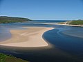 Durness (Scottish Gaelic: Diùirnis) is a huge but remote parish in the northwestern Highlands, encompassing all the land between the Moine to the East (separating it from Tongue parish) and the Gualin to the West (separating it from Eddrachilis).
 Aberdour Castle is located in the village of Easter Aberdour, Fife. Parts of the castle date from around 1200, making Aberdour one of the two oldest datable standing castles in Scotland, along with Castle Sween in Argyll, which was built at around the same time.
 St Margaret's Chapel, at Edinburgh Castle, is the oldest surviving building in Edinburgh. An example of Romanesque architecture, it is a Category A listed building. Legend had it that St. Margaret worshipped in this small chapel, but recent research indicates that it was built at the beginning of the 12th century by her fourth son who became King David I in 1124.
 Hopetoun House is the traditional residence of the Earl of Hopetoun (later the Marquess of Linlithgow). It was built 1699-1701, designed by William Bruce. It was then hugely extended from 1721 by William Adam until his death in 1748 being one of his most notable projects. The parklands in which it lies were laid out in 1725, also by William Adam.
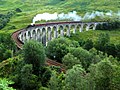 Glenfinnan Viaduct is a railway viaduct on the West Highland Line in Glenfinnan, Lochaber, Highland. It was built between 1897 and 1901. Located at the top of Loch Shiel in the West Highlands, the viaduct overlooks the Glenfinnan Monument and the waters of Loch Shiel.
 Castle Stalker (Scottish Gaelic: Caisteal an Stalcaire) is a four-storey tower house or keep picturesquely set on a tidal islet on Loch Laich, an inlet off Loch Linnhe. It is located about 1.5 miles (2.4 km) north east of Port Appin, Argyll.
 Scott's View refers to a viewpoint in the Scottish Borders, overlooking the valley of the River Tweed, which is reputed to be one of the favourite views of Sir Walter Scott. The viewpoint is around 3 miles east of Melrose.
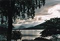 Loch Linnhe is a sea loch on the west coast of Scotland. The part upstream of Corran is known in Gaelic as An Linne Dhubh (the black pool, originally known as Loch Abar), and downstream as An Linne Sheileach (the salty pool). The name Linnhe is derived from the Gaelic word linne, meaning "pool".
 Bealach na Bà is a historic pass through the mountains of the Applecross peninsula, in Wester Ross in the Scottish Highlands—and the name of a famous twisting, single-track mountain road through the pass and mountains. The road is one of few in the Scottish Highlands that is engineered similarly to roads through the great mountain passes in the Alps, with very tight hairpin bends that switch back and forth up the hillside.


 Commons
 Wikibooks
 Wikidata
 Wikinews
 Wikiquote
 Wikisource
 Wikispecies
 Wikiversity
 Wikivoyage
 Wiktionary