
User:Morriswa/My OCONUS travel
Overview[edit]
This is a list of the places outside of the continental United States (e.g. OCONUS) to which I have traveled. Most of it was for United States Navy port visits.
Canada[edit]
When I was younger, my parents and I entered Canada. We traveled through the Canadian province of Ontario, but I don't remember when that was. The locations through which we traveled were:
- Niagara-on-the-Lake
- Niagara Falls
- St. Catharines
- Lincoln
- Grimsby
- Hamilton
- Brantford
- South-West Oxford
- Thames Centre
- London
- Southwold
- Dutton/Dunwich
- West Elgin
- Chatham-Kent
- Lakeshore
- Tecumseh
- Windsor
The List[edit]
Albania[edit]
-
 Flag of Albania
 -
 Albania's location in the world
 -
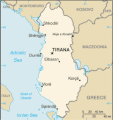 Map of Albania


- Durrës (41°48′40″N 019°26′21″E / 41.81111°N 19.43917°E)
- June 16, 2010
Bahrain[edit]
-
 Flag of Bahrain
 -
 Bahrain's location in the world
 -
 Map of Bahrain


- Manama (26°13′52″N 050°35′26″E / 26.23111°N 50.59056°E)
- December 2003 & early 2004
- Mina Sulman (26°12′04″N 50°36′25″E / 26.201°N 050.607°E)
- December, 2003 & early 2004
- Naval Support Activity Bahrain (26°12′35″N 050°36′35″E / 26.20972°N 50.60972°E)
- December, 2003 & early 2004
Bulgaria[edit]
-
 Flag of Bulgaria
 -
 Bulgaria's location in the world
 -
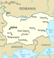 Map of Bulgaria


- Varna (43°12′22″N 027°54′25″E / 43.20611°N 27.90694°E)
- September 7, December 23, 24, & 25, 2008
Colombia[edit]
-
 Flag of Colombia
 -
 Colombia's location in the world
 -
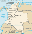 Map of Colombia


- Cartagena (10°24′12″N 075°32′25″W / 10.40333°N 75.54028°W)
- Late 2005 or early 2006 1
Croatia[edit]
-
 Flag of Croatia
 -
 Croatia's location in the world
 -
 Map of Croatia


- Split (43°30′36″N 016°27′00″E / 43.51000°N 16.45000°E)
- October 16, 17, & 19, 2008; June 24, 25, 26, & 27, 2010
- Split Naval Base (43°31′43″N 016°25′40″E / 43.52861°N 16.42778°E)
- October 16, 17 & 19, 2008; June 24, 25, 26, & 27, 2010
Denmark[edit]
-
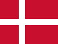 Flag of Denmark
 -
 Denmark's location in the world
 -
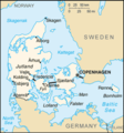 Map of Denmark


- Copenhagen (55°40′34″N 012°34′06″E / 55.67611°N 12.56833°E)
- August 12, 2010
France[edit]
-
 Flag of France
 -
 France's location in the world
 -
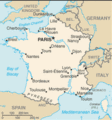 Map of France


- Brest (48°24′25″N 004°26′25″W / 48.40694°N 4.44028°W)
- September 26 & 28, 2010
- Nice (43°42′12″N 007°15′59″E / 43.70333°N 7.26639°E)
- July 4, 2010
- Toulon (43°07′33″N 005°55′50″E / 43.12583°N 5.93056°E)
- November 17-18, 2008
- Military port of Toulon (43°07′10″N 005°54′59″E / 43.11944°N 5.91639°E)
- November 17-18, 2008
- Villefranche (43°42′18″N 007°18′45″E / 43.70500°N 7.31250°E)
- July 2, 4, & 5, 2010
Greece[edit]
-
 Flag of Greece
 -
 Greece's location in the world
 -
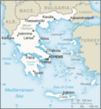 Map of Greece


- Heraklion/Iraklion (on Crete) (35°19′43″N 025°07′35″E / 35.32861°N 25.12639°E)
- October 9-10, 2008
- Naval Support Activity Souda Bay (on Crete) (35°29′46.5″N 024°08′51.5″E / 35.496250°N 24.147639°E)
- August 24 & December 19 2, 2008; January 14, 2009; July 28 3, 2010
Italy[edit]
-
 Flag of Italy
 -
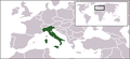 Italy's location in the world
 -
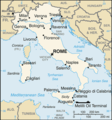 Map of Italy


- Civitavecchia (42°05′49″N 011°46′35″E / 42.09694°N 11.77639°E)
- September 22-23, 2008
- Naples (40°50′42″N 014°15′30″E / 40.84500°N 14.25833°E)
- Early 2004
- Rome (41°54′00″N 012°30′00″E / 41.90000°N 12.50000°E)
- Early 2004 & September 23, 2008
Netherlands[edit]
-
 Flag of the Netherlands
 -
 The location of the Netherlands in the world
 -
 Map of Netherlands


- Amsterdam (52°22′18″N 004°53′42″E / 52.37167°N 4.89500°E)
- August 18-19, 2010
- Leiden (52°09′33″N 004°29′48″E / 52.15917°N 4.49667°E)
- August 18-19, 2010
- Rotterdam (51°54′23″N 004°29′11″E / 51.90639°N 4.48639°E)
- August 18-19, 2010
- The Hague (52°03′46″N 004°18′36″E / 52.06278°N 4.31000°E)
- August 18-19, 2010
Curaçao (Territory of Netherlands)[edit]
-
 Flag of Curaçao
 -
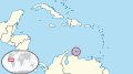 Curaçao's location in the world
 -
 Map of Curaçao


- Willemstad (12°10′42″N 069°01′03″W / 12.17833°N 69.01750°W)
- Late 2005 (few times); early 2006 (few times)
Norway[edit]
-
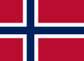 Flag of Norway
 -
 Norway's location in the world
 -
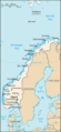 Map of Norway


- Stavanger (58°57′48″N 005°43′08″E / 58.96333°N 5.71889°E)
- August 24 & September 23, 2010
- Tromsø (69°40′58″N 018°56′34″E / 69.68278°N 18.94278°E)
- August 31, September 12, 16, & 17, 2010
Panama[edit]
-
 Flag of Panama
 -
 Panama's location in the world
 -
 Map of Panama


- Panama City (08°57′18″N 079°32′32″W / 8.95500°N 79.54222°W)
- Late 2005 (many times); early 2006 (many times)
- Vasco Nuñez de Balboa Naval Base (08°57′10″N 079°34′26″W / 8.95278°N 79.57389°W)
- Late 2005 (many times); early 2006 (many times)
Azores (autonomous region of Portugal[edit]
-
 Flag of the Azores
 -
 The location of the Azores in the world
 -
 Map of the Azores


- Ponta Delgada (on São Miguel Island island) (37°44′28″N 025°40′50″W / 37.74111°N 25.68056°W)
- May 1 4, 2010
Romania[edit]
-
 Flag of Romania
 -
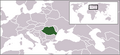 Romania's location in the world
 -
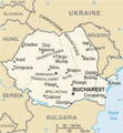 Map of Romania


- Constanţa (44°09′41″N 028°38′57″E / 44.16139°N 28.64917°E)
- August 28, 2008 & June 25 5, 2010
Russia[edit]
-
 Flag of Russia
 -
 Russia's location in the world
 -
 Map of Russia


- Murmansk (68°58′14″N 033°04′30″E / 68.97056°N 33.07500°E)
- September 7, 2010
Slovenia[edit]
-
 Flag of Slovenia
 -
 Slovenia's location in the world
 -
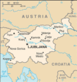 Map of Slovenia


- Koper (45°32′39″N 013°44′45″E / 45.54417°N 13.74583°E)
- October 23, 25, & 26, 2008
Spain[edit]
-
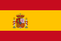 Flag of Spain
 -
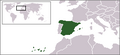 Spain's location in the world
 -
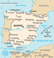 Map of Spain


- Cartagena (37°35′51″N 000°59′19″E / 37.59750°N 0.98861°E)
- May 21, 22, & 24, 2010
- Naval Station Mahón (on Minorca island) (39°53′48″N 004°15′41″E / 39.89667°N 4.26139°E)
- June 3 & 6, 2010
- A Coruña/La Coruña/Corunna (43°21′54″N 8°24′36″W / 43.365°N 008.410°W)
- October 3, 4, 5, 6, 7, & 10, 2010
- Mahón (on Menorca island) (39°53′28″N 004°15′40″E / 39.89111°N 4.26111°E)
- June 3 & 6, 2010
- Malaga (36°43′10″N 004°25′12″W / 36.71944°N 4.42000°W)
- Early 2004
- Naval Station Rota (36°37′15″N 006°19′54″W / 36.62083°N 6.33167°W)
- August 20 6, December 5, 6, 8, 9, 10, 11, 12, & 14, 2008; January 25-26, 2009; May 5, 6, 7, 8, 9, 10, 11, 12, 13 7, & August 3, 2010
- Puerto de Sagunto (39°39′05″N 000°12′44″W / 39.65139°N 0.21222°W)
- January 19, 20, & 22, 2009
- Rota (36°37′57″N 006°21′12″W / 36.63250°N 6.35333°W)
- December 11, 2008
- Sagunto (39°40′35″N 000°16′24″W / 39.67639°N 0.27333°W)
- January 19, 20 & 22, 2009
Turkey[edit]
-
 Flag of Turkey
 -
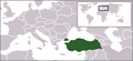 Turkey's location in the world
 -
 Map of Turkey


- Aksaz Naval Base (36°50′04″N 028°23′24″E / 36.83444°N 28.39000°E)
- November 8, 2008
- Istanbul (41°00′49″N 028°57′18″E / 41.01361°N 28.95500°E)
- September 12, 2008
- İzmir (38°26′23″N 027°08′11″E / 38.43972°N 27.13639°E)
- October 31, November 1, 2, & 4, 2008
- Marmaris (36°52′48″N 028°14′34″E / 36.88000°N 28.24278°E)
- November 8, 2008
- Samsun (41°17′25″N 036°20′01″E / 41.29028°N 36.33361°E)
- December 31, 2008; January 1-2, 2009
Ukraine[edit]
-
 Flag of Ukraine
 -
 Ukraine's location in the world
 -
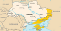 Map of Ukraine


.png)
- Odessa (46°29′08.6″N 030°44′36.4″E / 46.485722°N 30.743444°E)
- July 12, 13, 14, 15, 16, 17, & 23, 2010
United Arab Emirates[edit]
-
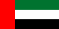 Flag of United Arab Emirates
 -
 The location of United Arab Emirates in the world
 -
 Map of United Arab Emirates


- Dubai (25°15′47″N 055°17′50″E / 25.26306°N 55.29722°E)
- December 2003 & early 2004
- Jebel Ali (25°00′41″N 55°03′40″E / 25.01126°N 055.06116°E)
- December 2003 & early 2004
Vatican City[edit]
-
 Flag of Vatican City
 -
 Vatican City's location in the world
 -
 Map of Vatican City
.svg)


- Vatican City (city-state) (41°54′09″N 012°27′09″E / 41.90250°N 12.45250°E)
- Early 2004; September 23, 2008
Notes[edit]
1: In either late 2005 or early 2006 (I have forgotten which), USS Gettysburg (CG-64), my first ship, anchored in the harbor of Cartagena, Columbia. Due to my previous knowledge of the city's history of drugs and crime, I did not go ashore.
2: On December 19, 2008, USS Taylor (FFG-50), my second ship, pulled into Naval Support Activity Souda Bay, Greece (located on the island of Crete). This was just for one night. My division finished our work day after liberty call had been called. Both of the E-6 and junior shipmates in my division couldn't go on liberty that day; therefore, they could not go ashore. Also, I couldn't find any other liberty buddies (that I trusted on liberty) after I showered. Therefore, I wasn't able to go ashore.
3: On July 28, 2010, USS Taylor pulled into Naval Support Activity Souda Bay, Greece (located on the island of Crete). However, this was only for a brief stop for fuel (BSF). I couldn't go on liberty that day (and had a watch as soon as we moored). Even though I had the afternoon watch-free, I had to participate in a working party. In addition, Taylor was delayed in leaving port, so our commanding officer (CO) authorized a brief libery call -- for everyone except for my duty section! Because of all this, I wasn't able to go ashore.
4: On May 1, 2010, USS Taylor pulled into Ponta Delgada, Portugal (located on the island of Săo Miguel, in the Azores). However, this was only for a BSF. Therefore, I wasn't able to go ashore.
5: On July 25, 2010, USS Taylor anchored off the coast of Constanţa, Romania. However, this was only for a BSF. Therfore, I wasn't able to go ashore.
6: On August 20, 2008, USS Taylor pulled into Rota Naval Station, near Rota, Spain. However, this was only for a BSF. Therfore, I wasn't able to go ashore.
7: On May 13, 2010, USS Taylor was inport Rota Naval Station, near Rota, Spain. However, I wasn't able to go ashore.
Views[edit]
Daily page views
|