
Portal:World
The World Portal


The world is the totality of entities, the whole of reality, or everything that exists. The nature of the world has been conceptualized differently in different fields. Some conceptions see the world as unique while others talk of a "plurality of worlds". Some treat the world as one simple object while others analyze the world as a complex made up of parts.
In scientific cosmology, the world or universe is commonly defined as "[t]he totality of all space and time; all that is, has been, and will be". Theories of modality talk of possible worlds as complete and consistent ways how things could have been. Phenomenology, starting from the horizon of co-given objects present in the periphery of every experience, defines the world as the biggest horizon or the "horizon of all horizons". In philosophy of mind, the world is contrasted with the mind as that which is represented by the mind. Theology conceptualizes the world in relation to God, for example, as God's creation, as identical to God or as the two being interdependent. In religions, there is a tendency to downgrade the material or sensory world in favor of a spiritual world to be sought through religious practice. A comprehensive representation of the world and our place in it, as is found in religions, is known as a worldview. Cosmogony is the field that studies the origin or creation of the world while eschatology refers to the science or doctrine of the last things or of the end of the world.
In various contexts, the term "world" takes a more restricted meaning associated, for example, with the Earth and all life on it, with humanity as a whole or with an international or intercontinental scope. In this sense, world history refers to the history of humanity as a whole and world politics is the discipline of political science studying issues that transcend nations and continents. Other examples include terms such as "world religion", "world language", "world government", "world war", "world population", "world economy", or "world championship". (Full article...)
Selected articles -
-


In world history, post-classical history refers to the period from about 500 CE to 1500 CE, roughly corresponding to the European Middle Ages. The period is characterized by the expansion of civilizations geographically and the development of trade networks between civilizations. This period is also called the medieval era, post-antiquity era, post-ancient era, pre-modernity era, or pre-modern era.
In Asia, the spread of Islam created a series of caliphates and inaugurated the Islamic Golden Age, leading to advances in science in the medieval Islamic world and trade among the Asian, African, and European continents. East Asia experienced the full establishment of the power of Imperial China, which established several prosperous dynasties influencing Japan, Korea, and Vietnam. Religions such as Buddhism and neo-Confucianism spread in the region. Gunpowder was developed in China during the post-classical era. The Mongol Empire connected Europe and Asia, creating safe trade and stability between the two regions. In total, the population of the world doubled in the time period, from approximately 210 million in 500 CE to 461 million in 1500 CE. The population generally grew steadily throughout the period but endured some incidental declines due to events including the Plague of Justinian, the Mongol invasions, and the Black Death. (Full article...) -
Great powers are recognized in several international structures, including the United Nations Security Council.
A great power is a sovereign state that is recognized as having the ability and expertise to exert its influence on a global scale. Great powers characteristically possess military and economic strength, as well as diplomatic and soft power influence, which may cause middle or small powers to consider the great powers' opinions before taking actions of their own. International relations theorists have posited that great power status can be characterized into power capabilities, spatial aspects, and status dimensions.
While some nations are widely considered to be great powers, there is considerable debate on the exact criteria of great power status. Historically, the status of great powers has been formally recognized in organizations such as the Congress of Vienna of 1814–1815 or the United Nations Security Council, of which permanent members are: China, France, Russia, the United Kingdom, and the United States. The United Nations Security Council, NATO Quint, the G7, the BRICs and the Contact Group have all been described as great power concerts. (Full article...) -
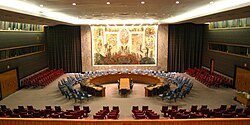
The United Nations (UN) is a diplomatic and political international organization whose stated purposes are to maintain international peace and security, develop friendly relations among nations, achieve international cooperation, and serve as a centre for harmonizing the actions of nations. It is the world's largest international organization. The UN is headquartered in New York City (in the United States, but with certain extraterritorial privileges), and the UN has other offices in Geneva, Nairobi, Vienna, and The Hague, where the International Court of Justice is headquartered at the Peace Palace.
The UN was established after World War II with the aim of preventing future world wars, and succeeded the League of Nations, which was characterized as ineffective. On 25 April 1945, 50 nations met in San Francisco, California for a conference and started drafting the UN Charter, which was adopted on 25 June 1945. The charter took effect on 24 October 1945, when the UN began operations. The UN's objectives, as defined by its charter, include maintaining international peace and security, protecting human rights, delivering humanitarian aid, promoting sustainable development, and upholding international law. At its founding, the UN had 51 member states; , it has 193 – almost all of the world's sovereign states. (Full article...) -
The United Nations Climate Change Conferences are yearly conferences held in the framework of the United Nations Framework Convention on Climate Change (UNFCCC). They serve as the formal meeting of the UNFCCC parties – the Conference of the Parties (COP) – to assess progress in dealing with climate change, and beginning in the mid-1990s, to negotiate the Kyoto Protocol to establish legally binding obligations for developed countries to reduce their greenhouse gas emissions. Starting in 2005 the conferences have also served as the "Conference of the Parties Serving as the Meeting of Parties to the Kyoto Protocol" (CMP); also parties to the convention that are not parties to the protocol can participate in protocol-related meetings as observers. From 2011 to 2015 the meetings were used to negotiate the Paris Agreement as part of the Durban platform, which created a general path towards climate action. Any final text of a COP must be agreed by consensus.
The first UN Climate Change Conference was held in 1995 in Berlin. (Full article...) -
The international community is a term used in geopolitics and international relations to refer to a broad group of people and governments of the world. (Full article...)
-
Global village describes the phenomenon of the entire world becoming more interconnected as the result of the propagation of media technologies throughout the world. The term was coined by Canadian media theorist Marshall McLuhan in his books The Gutenberg Galaxy: The Making of Typographic Man (1962) and Understanding Media (1964). Literary scholar Sue-Im Lee describes how the term global village has come to designate “the dominant term for expressing a global coexistence altered by transnational commerce, migration, and culture” (as cited in Poll, 2012). Economic journalist Thomas Friedman's definition of the global village as a world “tied together into a single globalized marketplace and village” is another contemporary understanding of the term (as cited in Poll, 2012). (Full article...)
-
The World Factbook, also known as the CIA World Factbook, is a reference resource produced by the Central Intelligence Agency (CIA) with almanac-style information about the countries of the world. The official print version is available from the Government Publishing Office. The Factbook is available in the form of a website that is partially updated every week. It is also available for download for use off-line. It provides a two- to three-page summary of the demographics, geography, communications, government, economy, and military of 266 international entities, including U.S.-recognized countries, dependencies, and other areas in the world.
The World Factbook is prepared by the CIA for the use of U.S. government officials, and its style, format, coverage, and content are primarily designed to meet their requirements. It is also frequently used as a resource for academic research papers and news articles. As a work of the U.S. government, it is in the public domain in the United States. (Full article...)


.jpg)

General images -
-
 Artist's rendition of an oxinated fully-frozen Snowball Earth with no remaining liquid surface water. (from History of Earth)
 -
 Earth's night-side upper atmosphere appearing from the bottom as bands of afterglow illuminating the troposphere in orange with silhouettes of clouds, and the stratosphere in white and blue. Next the mesosphere (pink area) extends to the orange and faintly green line of the lowest airglow, at about one hundred kilometers at the edge of space and the lower edge of the thermosphere (invisible). Continuing with green and red bands of aurorae stretching over several hundred kilometers. (from Earth)
 -
 The pale orange dot, an artist's impression of the early Earth which might have appeared orange through its hazy methane rich prebiotic second atmosphere. Earth's atmosphere at this stage was somewhat comparable to today's atmosphere of Titan. (from History of Earth)
 -
 A composite image of artificial light emissions at night on a map of Earth (from Earth)
 -
 "Lucy", the first Australopithecus afarensis skeleton found. Lucy was only 1.06 m (3 ft 6 in) tall.
 -
 A computer-generated image mapping the prevalence of artificial satellites and space debris around Earth in geosynchronous and low Earth orbit (from Earth)
 -

-

-
 Earth's land use for human agriculture in 2019 (from Earth)
 -
 A view of Earth with its global ocean and cloud cover, which dominate Earth's surface and hydrosphere; at Earth's polar regions, its hydrosphere forms larger areas of ice cover. (from Earth)
 -
 Tracy Caldwell Dyson, a NASA astronaut, observing Earth from the Cupola module at the International Space Station on 11 September 2010 (from Earth)
 -

-
 Vitruvian Man by Leonardo da Vinci epitomizes the advances in art and science seen during the Renaissance. (from History of Earth)
 -
 Trilobites first appeared during the Cambrian period and were among the most widespread and diverse groups of Paleozoic organisms. (from History of Earth)
 -
 Chloroplasts in the cells of a moss (from History of Earth)
 -
 Last Moon landing: Apollo 17 (1972)
 -
 Lithified stromatolites on the shores of Lake Thetis, Western Australia. Archean stromatolites are the first direct fossil traces of life on Earth. (from History of Earth)
 -
 An artist's impression of the Archean, the eon after Earth's formation, featuring round stromatolites, which are early oxygen-producing forms of life from billions of years ago. After the Late Heavy Bombardment, Earth's crust had cooled, its water-rich barren surface is marked by continents and volcanoes, with the Moon still orbiting Earth half as far as it is today, appearing 2.8 times larger and producing strong tides. (from Earth)
 -
 Earth's axial tilt causing different angles of seasonal illumination at different orbital positions around the Sun (from Earth)
 -

-
 Ajloun Castle, Jordan
 -
 Angkor Wat temple complex, Cambodia, early 12th century
 -
 Tiktaalik, a fish with limb-like fins and a predecessor of tetrapods. Reconstruction from fossils about 375 million years old. (from History of Earth)
 -
 An artist's impression of ice age Earth at glacial maximum. (from History of Earth)
 -
 Artist's conception of Hadean Eon Earth, when it was much hotter and inhospitable to all forms of life. (from History of Earth)
 -

-
Artist's impression of Earth during the later Archean, the largely cooled planetary crust and water-rich barren surface, marked by volcanoes and continents, features already round microbialites. The Moon, still orbiting Earth much closer than today and still dominating Earth's sky, produced strong tides. (from History of Earth)
-
 An artist's rendering of a protoplanetary disk (from History of Earth)
 -
 Dinosaurs were the dominant terrestrial vertebrates throughout most of the Mesozoic (from History of Earth)
 -
 A map of heat flow from Earth's interior to the surface of Earth's crust, mostly along the oceanic ridges (from Earth)
 -
 A reconstruction of human history based on fossil data. (from History of Earth)
 -
 A reconstruction of Pannotia (550 Ma). (from History of Earth)
 -
 Machu Picchu, Inca Empire, Peru
 -

-
 Change in average surface air temperature and drivers for that change. Human activity has caused increased temperatures, with natural forces adding some variability. (from Earth)
 -
 Map of peopling of the world (Southern Dispersal paradigm), in thousands of years ago.
 -

-
 Geologic map of North America, color-coded by age. From most recent to oldest, age is indicated by yellow, green, blue, and red. The reds and pinks indicate rock from the Archean.
 -
 A pillar at Göbekli Tepe
 -

-
 A 2012 artistic impression of the early Solar System's protoplanetary disk from which Earth and other Solar System bodies were formed (from Earth)
 -
 Earth's history with time-spans of the eons to scale (from History of Earth)
 -
 Fall of the Berlin Wall, 1989
 -
 Olmec colossal head, now at the Museo de Antropología de Xalapa
 -
 Artist's conception of Devonian flora (from History of Earth)
 -
 Artist's impression of a Hadean landscape with the relatively newly formed Moon still looming closely over Earth and both bodies sustaining strong volcanism. (from History of Earth)
 -
 Shanghai. China urbanized rapidly in the 21st century.
 -
 Chennakesava Temple, Belur, India
 -

-
 View of Earth from the Moon by the Lunar Reconnaissance Orbiter (from Earth)
 -

-

-
 Taj Mahal, Mughal Empire, India
 -
 Japanese depiction of a Portuguese carrack. European maritime innovations led to proto-globalization.
 -
 A 580 million year old fossil of Spriggina floundensi, an animal from the Ediacaran period. Such life forms could have been ancestors to the many new forms that originated in the Cambrian Explosion. (from History of Earth)
 -

-
 The Pantheon, originally a Roman temple, now a Catholic church
 -
 Artist's impression of the enormous collision that probably formed the Moon (from History of Earth)
 -
 Image of the physical world, captured by the Hubble Space Telescope (from World)
 -
 Cross-section through a liposome (from History of Earth)
 -
 An animation of the changing density of productive vegetation on land (low in brown; heavy in dark green) and phytoplankton at the ocean surface (low in purple; high in yellow) (from Earth)
 -

-

-
 A banded iron formation from the 3.15 Ga Moodies Group, Barberton Greenstone Belt, South Africa. Red layers represent the times when oxygen was available; gray layers were formed in anoxic circumstances. (from History of Earth)
 -
 Great Pyramids of Giza, Egypt
 -
 Stone monuments (moai) on Rapa Nui, thought to represent high-ranking ancestors (from Human history)
 -
 A schematic view of Earth's magnetosphere with solar wind flowing from left to right (from Earth)
 -

-
 Pangaea was a supercontinent that existed from about 300 to 180 Ma. The outlines of the modern continents and other landmasses are indicated on this map. (from History of Earth)
 -
 Yggdrasil, an attempt to reconstruct the Norse world tree which connects the heavens, the world, and the underworld. (from World)
 -
 Satellite time lapse imagery of Earth's rotation showing axis tilt (from Earth)
 -
 The replicator in virtually all known life is deoxyribonucleic acid. DNA is far more complex than the original replicator and its replication systems are highly elaborate. (from History of Earth)
 -

-
 A composite image of Earth, with its different types of surface discernible: Earth's surface dominating Ocean (blue), Africa with lush (green) to dry (brown) land and Earth's polar ice in the form of Antarctic sea ice (grey) covering the Antarctic or Southern Ocean and the Antarctic ice sheet (white) covering Antarctica. (from Earth)
 -
 Persepolis, Achaemenid Empire, 6th century BCE
 -

-

-
 First airplane, the Wright Flyer, flew on 17 December 1903.
 -
Pale orange dot, an artist's impression of Early Earth, featuring its tinted orange methane-rich early atmosphere (from Earth)
-
 Florence, birthplace of the Italian Renaissance
 -
 Notre-Dame de Paris, France
 -
 Battle during the 1281 Mongol invasion of Japan
 -
 Obelisk of Axum, Ethiopia
 -
 Standing Buddha from Gandhara, 2nd century CE
 -
 Empires of the world in 1898
 -
 Graph showing range of estimated partial pressure of atmospheric oxygen through geologic time (from History of Earth)
 -
 A Benin Bronze head from Nigeria
 -
 Ming dynasty section, Great Wall of China
 -
 A view of Earth with different layers of its atmosphere visible: the troposphere with its clouds casting shadows, a band of stratospheric blue sky at the horizon, and a line of green airglow of the lower thermosphere around an altitude of 100 km, at the edge of space (from Earth)
 -
 Earth's western hemisphere showing topography relative to Earth's center instead of to mean sea level, as in common topographic maps (from Earth)
 -
 Great Mosque of Kairouan, Tunisia, founded 670 CE


.jpg)


.jpg)


.svg)


.jpg)


.jpeg)


Megacities of the world -

Istanbul, is the largest city in Turkey, straddling the Bosporus Strait, the boundary between Europe and Asia. It is considered the country's economic, cultural and historic capital. The city has a population of over 15 million residents, comprising 19% of the population of Turkey, and is the most populous city in Europe and the world's fifteenth-largest city.
The city was founded as Byzantium in the 7th century BCE by Greek settlers from Megara. In 330 CE, the Roman emperor Constantine the Great made it his imperial capital, renaming it first as New Rome (Ancient Greek: Νέα Ῥώμη Nea Rhomē; Latin: Nova Roma) and then finally as Constantinople (Constantinopolis) after himself. In 1930, the city's name was officially changed to Istanbul, the Turkish rendering of εἰς τὴν Πόλιν eis tḕn Pólin 'to the City', the appellation Greek speakers used since the 11th century to colloquially refer to the city. (Full article...)Did you know -

- ... that the tripartite structure of the National War Labor Board helped the United States keep work stoppages to a minimum during World War II?
- ... that while preparing for War Horse, theatre set designer Rae Smith spent weeks pretending to be a First World War British Army captain?
- ... that Asma Al Thani, who directs the Qatar Olympic Committee's communications, has climbed the world's eighth-highest mountain and skied to the North Pole?
- ... that Derrick Palmer and Chris Smalls, leaders of the Amazon Labor Union, were named two of the "100 most influential people in the world" in 2022?
- ... that Ron Labinski has been described as the world's first sports-venue architect?
- ... that Marita Camacho Quirós, who was First Lady of Costa Rica (1962–1966), is the oldest former first lady in the world and a supercentenarian?
- ... that the final of the 2009 IBSF women's snooker championship was interrupted so that drug tests could be conducted on the players?
- ... that Turkey is the world's largest grower of hazelnuts, apricots, and oregano?
Countries of the world -

Morocco, officially the Kingdom of Morocco, is a country in the Maghreb region of North Africa. It overlooks the Mediterranean Sea to the north and the Atlantic Ocean to the west, and has land borders with Algeria to the east, and the disputed territory of Western Sahara to the south. Morocco also claims the Spanish exclaves of Ceuta, Melilla and Peñón de Vélez de la Gomera, and several small Spanish-controlled islands off its coast. It has a population of roughly 37 million, the official and predominant religion is Islam, and the official languages are Arabic and Berber; French and the Moroccan dialect of Arabic are also widely spoken. Moroccan identity and culture is a mix of Arab, Berber, African and European cultures. Its capital is Rabat, while its largest city is Casablanca.
The region constituting Morocco has been inhabited since the Paleolithic era over 300,000 years ago. The Idrisid dynasty was established by Idris I in 788 and was subsequently ruled by a series of other independent dynasties, reaching its zenith as a regional power in the 11th and 12th centuries, under the Almoravid and Almohad dynasties, when it controlled most of the Iberian Peninsula and the Maghreb. Centuries of Arab migration to the Maghreb since the 7th century shifted the demographic scope of the region. In the 15th and 16th centuries, Morocco faced external threats to its sovereignty, with Portugal seizing some territory and the Ottoman Empire encroaching from the east. The Marinid and Saadi dynasties otherwise resisted foreign domination, and Morocco was the only North African nation to escape Ottoman dominion. The 'Alawi dynasty, which rules the country to this day, seized power in 1631, and over the next two centuries expanded diplomatic and commercial relations with the Western world. Morocco's strategic location near the mouth of the Mediterranean drew renewed European interest; in 1912, France and Spain divided the country into respective protectorates, reserving an international zone in Tangier. Following intermittent riots and revolts against colonial rule, in 1956, Morocco regained its independence and reunified. (Full article...)Related portals
Protected areas of the world -
-
The country of Burundi in Africa has the following national parks and other protected areas. (Full article...)
-
The protected areas of Nepal cover mainly forested land and are located at various altitudes in the Terai, in the foothills of the Himalayas and in the mountains, thus encompassing a multitude of landscapes and preserving a vast biodiversity in the Palearctic and Indomalayan realms.
Nepal covers 147,181 km2 (56,827 sq mi) in the central part of the Himalayas. Altitudes range from 67 m (220 ft) in the south-eastern Terai to 8,848 m (29,029 ft) at Mount Everest within a short horizontal span. This extreme altitudinal gradient has resulted in 11 bio-climatic zones ranging from lower tropical below 500 m (1,600 ft) to nival above 5,000 m (16,000 ft) in the High Himalayas, encompassing nine terrestrial ecoregions with 36 vegetation types.
Additionally, nine Ramsar sites were declared between 1988 and 2008. Two wildlife reserves were declared as national parks in 2017. (Full article...) -

There are numerous parks throughout the sovereign island country of Singapore. This is a list of parks in Singapore that are currently existing and have articles on Wikipedia. Most parks in Singapore are managed by the National Parks Board, although smaller neighbourhood parks are managed by the Housing Development Board. Most of these parks are connected via the Park Connector Network (PCN). (Full article...) -
The Ulyanovsk Oblast in Russia contains about 118 protected natural areas. (Full article...)
-
Dinosaur Provincial Park
This is a list of protected areas of Alberta. Protected areas are managed by the Government of Canada or the Government of Alberta. The provincial government owns 60% of Alberta's landmass but most of this has not been formally protected. The total protected area throughout Alberta including federal and provincial protected areas is approximately 90,700 km2 (35,000 sq mi). (Full article...) -
The protected areas of Finland include national parks, nature reserves and other areas, with a purpose of conserving areas of all of Finland's ecosystems and biotopes.
Protected areas include:- National parks of Finland (Kansallispuisto/Nationalpark) - 8,170 km2
- Strict nature reserves of Finland (Luonnonpuisto/Naturreservat) - 1,530 km2
- Mire reserves of Finland (Soidensuojelualue/Myrskyddsområde) - 4,490 km2
- Protected herb-rich forest areas (Lehtojensuojelualue/Lundskyddsområde) - 13 km2
- Protected old-growth forest areas (Vanhat metsät/Gamla skogar) - 100 km2
- Grey seal protection areas (Hylkeidensuojelualue/Sälskyddsområde) - 190 km2
- Other protected areas on state-owned land - 468 km2
-
The Protected areas of New South Wales include both terrestrial and marine protected areas. there are 225 national parks in New South Wales. A number established since the late 1970s followed campaigns by local residents and environmentalists.
Based on the Collaborative Australian Protected Area Database (CAPAD) 2020 data there are 2136 separate terrestrial protected areas with a total land area of 7,696,641 hectares (19,018,810 acres) (9.61% of the state's area). CAPAD data also shows 18 marine protected areas with a total area of 348,849 hectares (862,020 acres), covering 39.63% of NSW waters. (Full article...) -
-
The Valley of the Giants skywalk at Walpole-Nornalup National Park
Western Australia is the second largest country subdivision in the world.
As of 2022, based on the latest Collaborative Australian Protected Areas Database report, it contains 1857 separate land-based protected areas with a total area of 76,142,710 hectares (188,152,700 acres), accounting for just over 30 percent of the state's land mass. By area, Indigenous Protected Areas account for the largest part of this, almost 67 percent while, by number, nature reserves hold the majority with two-third of all land-based protected areas being nature reserves. (Full article...) -

In the Philippines, Protected Areas are administered by the Department of Environment and Natural Resources (DENR)'s Biodiversity Management Bureau under the National Integrated Protected Areas System (NIPAS) Act of 1992. As of 2020, there are 244 Protected Areas in the Philippines covering a total area of about 7,760,000 hectares (19,200,000 acres) – 15.4% of the Philippines' total area. (Full article...) -
Cadw is the historic environment service of the Welsh Government which manages historical buildings and ancient monuments in Wales. (Full article...)
-
A National Biodiversity Conservation Area (NBCA) is an environmentally protected area in Laos. There are all together 21 different NBCAs in Laos, protecting 29,775 square kilometers. Another 10 NBCAs have been proposed, many of them being treated by authorities as though they were already officially protected. (Full article...)
-
Greece is characterized by an extremely fragmented, rugged landscape hosting a great diversity of ecosystems and an outstanding biodiversity. Almost 5% of its extensive coastline consists of ecologically sensitive wetlands. Two thirds of the total population live no further than 2 km from the coast and most of the important urban centers are coastal, while almost all of the tourist infrastructure is divided among islands and the coastal mainland. (Full article...)
-
The protected areas of South Africa include national parks and marine protected areas managed by the national government, public nature reserves managed by provincial and local governments, and private nature reserves managed by private landowners. Most protected areas are intended for the conservation of flora and fauna. National parks are maintained by South African National Parks (SANParks). A number of national parks have been incorporated in transfrontier conservation areas.
Protected areas may also be protected for their value and importance as historical, cultural heritage or scientific sites. More information on these can be found in the list of heritage sites in South Africa. (Full article...) -
Papua New Guinea is home to several protected areas, which receive protection because of their environmental, cultural or similar value.
The total area of Papua New Guinea protected territories is 14,330 km2 (5,530 sq mi), which amounts to approximately 3.07% of the country's territory. The total number of protected areas as 2018 is 71. (Full article...)


Selected world maps
-
 The Goode homolosine projection is a pseudocylindrical, equal-area, composite map projection used for world maps.
 -
 Only a few of the largest large igneous provinces appear (coloured dark purple) on this geological map, which depicts crustal geologic provinces as seen in seismic refraction data
 -
 United Nations Human Development Index map by country (2016)
 -
 A plate tectonics map with volcano locations indicated with red circles
 -
 1516 map of the world by Martin Waldseemüller
 -
 Time zones of the world
 -
 Mollweide projection of the world
 -
 Index map from the International Map of the World (1:1,000,000 scale)
 -
 The world map by Gerardus Mercator (1569), the first map in the well-known Mercator projection


World records
- List of Olympic records in athletics
- List of world records in athletics
- List of junior world records in athletics
- List of world records in masters athletics
- List of world youth bests in athletics
- List of IPC world records in athletics
- List of world records in canoeing
- List of world records in chess
- List of cycling records
- List of world records in track cycling
- List of world records in finswimming
- List of world records in juggling
- List of world records in rowing
- List of world records in speed skating
- List of world records in swimming
- List of IPC world records in swimming
- List of world records in Olympic weightlifting
Topics

Continents of Earth | ||||||||
|---|---|---|---|---|---|---|---|---|
| ||||||||
| ||||||||
| ||||||||


| Cenozoic Era (present–66.0 Ma) |
| ||||||||||||
|---|---|---|---|---|---|---|---|---|---|---|---|---|---|
| Mesozoic Era (66.0–252 Ma) |
| ||||||||||||
| Paleozoic Era (252–539 Ma) |
| ||||||||||||
| Proterozoic Eon (539 Ma–2.5 Ga) |
| ||||||||||||
| Archean Eon (2.5–4 Ga) | |||||||||||||
| Hadean Eon (4–4.6 Ga) | |||||||||||||
ka = kiloannum (thousands years ago); Ma = megaannum (millions years ago); Ga = gigaannum (billions years ago). See also: Geologic time scale • | |||||||||||||
| Locations | ||
|---|---|---|
| Related | ||

| |||||||||||||||||||
| |||||||||||||||||||
| |||||||||||||||||||

Economic classification of countries | |||||
|---|---|---|---|---|---|
| Three-World Model | |||||
| Gross domestic product (GDP) |
| ||||
| Gross national income (GNI) | |||||
| Wages | |||||
| Wealth | |||||
| Other national accounts | |||||
| Human development | |||||
| Digital divide | |||||
| Net international investment position (NIIP) | |||||
| Technological |
| ||||
|---|---|---|---|---|---|
| Sociological | |||||
| Ecological |
| ||||
| Biological |
| ||||
| Astronomical | |||||
| Eschatological |
| ||||
| Others |
| ||||
| Fictional | |||||
| Organizations | |||||
Categories

Wikimedia
The following Wikimedia Foundation sister projects provide more on this subject:
-
 Commons
Free media repository -
 Wikibooks
Free textbooks and manuals -
 Wikidata
Free knowledge base -
 Wikinews
Free-content news -
 Wikiquote
Collection of quotations -
 Wikisource
Free-content library -
 Wikispecies
Directory of species -
 Wikiversity
Free learning tools -
 Wikivoyage
Free travel guide -
 Wiktionary
Dictionary and thesaurus


