
Portal:World
The World Portal


The world is the totality of entities, the whole of reality, or everything that exists. The nature of the world has been conceptualized differently in different fields. Some conceptions see the world as unique while others talk of a "plurality of worlds". Some treat the world as one simple object while others analyze the world as a complex made up of parts.
In scientific cosmology, the world or universe is commonly defined as "[t]he totality of all space and time; all that is, has been, and will be". Theories of modality talk of possible worlds as complete and consistent ways how things could have been. Phenomenology, starting from the horizon of co-given objects present in the periphery of every experience, defines the world as the biggest horizon or the "horizon of all horizons". In philosophy of mind, the world is contrasted with the mind as that which is represented by the mind. Theology conceptualizes the world in relation to God, for example, as God's creation, as identical to God or as the two being interdependent. In religions, there is a tendency to downgrade the material or sensory world in favor of a spiritual world to be sought through religious practice. A comprehensive representation of the world and our place in it, as is found in religions, is known as a worldview. Cosmogony is the field that studies the origin or creation of the world while eschatology refers to the science or doctrine of the last things or of the end of the world.
In various contexts, the term "world" takes a more restricted meaning associated, for example, with the Earth and all life on it, with humanity as a whole or with an international or intercontinental scope. In this sense, world history refers to the history of humanity as a whole and world politics is the discipline of political science studying issues that transcend nations and continents. Other examples include terms such as "world religion", "world language", "world government", "world war", "world population", "world economy", or "world championship". (Full article...)
Selected articles -
-


A facsimile of the signature-and-seals page of the 1864 Geneva Convention, which established humane rules of war
The Geneva Conventions are international humanitarian laws consisting of four treaties and three additional protocols that establish international legal standards for humanitarian treatment in war. The singular term Geneva Convention colloquially denotes the agreements of 1949, negotiated in the aftermath of the Second World War (1939–1945), which updated the terms of the two 1929 treaties and added two new conventions. The Geneva Conventions extensively define the basic rights of wartime prisoners, civilians and military personnel; establish protections for the wounded and sick; and provide protections for the civilians in and around a war-zone.
The Geneva Conventions define the rights and protections afforded to non-combatants who fulfill the criteria of being protected persons. The treaties of 1949 were ratified, in their entirety or with reservations, by 196 countries. The Geneva Conventions concern only protected non-combatants in war. The use of wartime conventional weapons is addressed by the Hague Conventions of 1899 and 1907 and the 1980 Convention on Certain Conventional Weapons, while the biological and chemical warfare in international armed conflicts is addressed by the 1925 Geneva Protocol. (Full article...) -
The earliest known world maps date to classical antiquity, the oldest examples of the 6th to 5th centuries BCE still based on the flat Earth paradigm. World maps assuming a spherical Earth first appear in the Hellenistic period. The developments of Greek geography during this time, notably by Eratosthenes and Posidonius culminated in the Roman era, with Ptolemy's world map (2nd century CE), which would remain authoritative throughout the Middle Ages. Since Ptolemy, knowledge of the approximate size of the Earth allowed cartographers to estimate the extent of their geographical knowledge, and to indicate parts of the planet known to exist but not yet explored as terra incognita.
With the Age of Discovery, during the 15th to 18th centuries, world maps became increasingly accurate; exploration of Antarctica, Australia, and the interior of Africa by western mapmakers was left to the 19th and early 20th century. (Full article...) -
Economic globalization is one of the three main dimensions of globalization commonly found in academic literature, with the two others being political globalization and cultural globalization, as well as the general term of globalization.
Economic globalization refers to the widespread international movement of goods, capital, services, technology and information. It is the increasing economic integration and interdependence of national, regional, and local economies across the world through an intensification of cross-border movement of goods, services, technologies and capital. Economic globalization primarily comprises the globalization of production, finance, markets, technology, organizational regimes, institutions, corporations, and people.
While economic globalization has been expanding since the emergence of trans-national trade, it has grown at an increased rate due to improvements in the efficiency of long-distance transportation, advances in telecommunication, the importance of information rather than physical capital in the modern economy, and by developments in science and technology. The rate of globalization has also increased under the framework of the General Agreement on Tariffs and Trade and the World Trade Organization, in which countries gradually cut down trade barriers and opened up their current accounts and capital accounts. This recent boom has been largely supported by developed economies integrating with developing countries through foreign direct investment, lowering costs of doing business, the reduction of trade barriers, and in many cases cross-border migration. (Full article...) -

The FIFA World Cup, often simply called the World Cup, is an international association football competition among the senior men's national teams of the members of the Fédération Internationale de Football Association (FIFA), the sport's global governing body. The tournament has been held every four years since the inaugural tournament in 1930, with the exception of 1942 and 1946 due to the Second World War. The reigning champions are Argentina, who won their third title at the 2022 tournament.
The contest starts with the qualification phase, which takes place over the preceding three years to determine which teams qualify for the tournament phase. In the tournament phase, 32 teams compete for the title at venues within the host nation(s) over the course of about a month. The host nation(s) automatically qualify for the group stage of the tournament. The competition is scheduled to expand to 48 teams, starting with the 2026 tournament. (Full article...) -
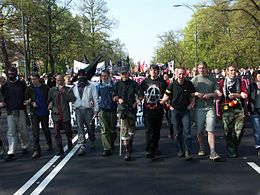
Thousands of people gathered for a demonstration in Warsaw, the capital of Poland, as the country prepared to enter the European Union in 2004.
The anti-globalization movement, or counter-globalization movement, is a social movement critical of economic globalization. The movement is also commonly referred to as the global justice movement, alter-globalization movement, anti-globalist movement, anti-corporate globalization movement, or movement against neoliberal globalization. There are many definitions of anti-globalization.
Participants base their criticisms on a number of related ideas. What is shared is that participants oppose large, multinational corporations having unregulated political power, exercised through trade agreements and deregulated financial markets. Specifically, corporations are accused of seeking to maximize profit at the expense of work safety conditions and standards, labour hiring and compensation standards, environmental conservation principles, and the integrity of national legislative authority, independence and sovereignty. Some commentators have variously characterized changes in the global economy as "turbo-capitalism" (Edward Luttwak), "market fundamentalism" (George Soros), "casino capitalism" (Susan Strange), and as "McWorld" (Benjamin Barber). (Full article...) -
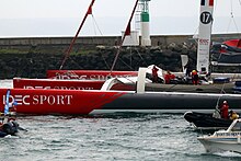
IDEC 3, current outright record holder at 40 days, 23 hours, 30 minutes and 30 seconds.
The first around the world sailing record for circumnavigation of the world can be attributed to the surviving crew of Ferdinand Magellan's expedition, including the last captain Juan Sebastián Elcano who completed their journey in 1522.
Although not in a single voyage but Magellan was technically the first to circumnavigate the globe since he was killed in the Mactan Islands and while in the Kingdom of Portugal's service, Magellan had already reached the Malay Archipelago in Southeast Asia on previous voyages traveling east (from 1505 to 1511–1512). By visiting this area again but now traveling west, Magellan achieved a nearly complete personal circumnavigation of the globe for the first time in history. (Full article...) -
Universal Time (UT or UT1) is a time standard based on Earth's rotation. While originally it was mean solar time at 0° longitude, precise measurements of the Sun are difficult. Therefore, UT1 is computed from a measure of the Earth's angle with respect to the International Celestial Reference Frame (ICRF), called the Earth Rotation Angle (ERA, which serves as the replacement for Greenwich Mean Sidereal Time). UT1 is the same everywhere on Earth. UT1 is required to follow the relationship
:ERA = 2π(0.7790572732640 + 1.00273781191135448 · Tu) radians
where Tu = (Julian UT1 date − 2451545.0). (Full article...)


General images -
-
 Change in average surface air temperature and drivers for that change. Human activity has caused increased temperatures, with natural forces adding some variability. (from Earth)
 -
 A reconstruction of Pannotia (550 Ma). (from History of Earth)
 -
 Artist's rendition of an oxinated fully-frozen Snowball Earth with no remaining liquid surface water. (from History of Earth)
 -
 Artist's conception of Hadean Eon Earth, when it was much hotter and inhospitable to all forms of life. (from History of Earth)
 -
 A 2012 artistic impression of the early Solar System's protoplanetary disk from which Earth and other Solar System bodies were formed (from Earth)
 -
 Angkor Wat temple complex, Cambodia, early 12th century
 -
 Dinosaurs were the dominant terrestrial vertebrates throughout most of the Mesozoic (from History of Earth)
 -
 Earth's night-side upper atmosphere appearing from the bottom as bands of afterglow illuminating the troposphere in orange with silhouettes of clouds, and the stratosphere in white and blue. Next the mesosphere (pink area) extends to the orange and faintly green line of the lowest airglow, at about one hundred kilometers at the edge of space and the lower edge of the thermosphere (invisible). Continuing with green and red bands of aurorae stretching over several hundred kilometers. (from Earth)
 -

-
 Ajloun Castle, Jordan
 -

-
 Olmec colossal head, now at the Museo de Antropología de Xalapa
 -
 Map of peopling of the world (Southern Dispersal paradigm), in thousands of years ago.
 -
 "Lucy", the first Australopithecus afarensis skeleton found. Lucy was only 1.06 m (3 ft 6 in) tall.
 -
 Earth's history with time-spans of the eons to scale (from History of Earth)
 -
 The pale orange dot, an artist's impression of the early Earth which might have appeared orange through its hazy methane rich prebiotic second atmosphere. Earth's atmosphere at this stage was somewhat comparable to today's atmosphere of Titan. (from History of Earth)
 -
 A pillar at Göbekli Tepe
 -
 Chennakesava Temple, Belur, India
 -
 Earth's land use for human agriculture in 2019 (from Earth)
 -
 Empires of the world in 1898
 -

-
 Persepolis, Achaemenid Empire, 6th century BCE
 -
 A reconstruction of human history based on fossil data. (from History of Earth)
 -
 Ming dynasty section, Great Wall of China
 -
 The replicator in virtually all known life is deoxyribonucleic acid. DNA is far more complex than the original replicator and its replication systems are highly elaborate. (from History of Earth)
 -

-
 A view of Earth with different layers of its atmosphere visible: the troposphere with its clouds casting shadows, a band of stratospheric blue sky at the horizon, and a line of green airglow of the lower thermosphere around an altitude of 100 km, at the edge of space (from Earth)
 -
 An animation of the changing density of productive vegetation on land (low in brown; heavy in dark green) and phytoplankton at the ocean surface (low in purple; high in yellow) (from Earth)
 -

-
 Notre-Dame de Paris, France
 -
 Japanese depiction of a Portuguese carrack. European maritime innovations led to proto-globalization.
 -

-

-
 Lithified stromatolites on the shores of Lake Thetis, Western Australia. Archean stromatolites are the first direct fossil traces of life on Earth. (from History of Earth)
 -
 Trilobites first appeared during the Cambrian period and were among the most widespread and diverse groups of Paleozoic organisms. (from History of Earth)
 -
 Satellite time lapse imagery of Earth's rotation showing axis tilt (from Earth)
 -

-
 Florence, birthplace of the Italian Renaissance
 -
 Chloroplasts in the cells of a moss (from History of Earth)
 -
 Tiktaalik, a fish with limb-like fins and a predecessor of tetrapods. Reconstruction from fossils about 375 million years old. (from History of Earth)
 -
 Vitruvian Man by Leonardo da Vinci epitomizes the advances in art and science seen during the Renaissance. (from History of Earth)
 -

-
 Geologic map of North America, color-coded by age. From most recent to oldest, age is indicated by yellow, green, blue, and red. The reds and pinks indicate rock from the Archean.
 -

-
 A map of heat flow from Earth's interior to the surface of Earth's crust, mostly along the oceanic ridges (from Earth)
 -
 A composite image of artificial light emissions at night on a map of Earth (from Earth)
 -
 Earth's axial tilt causing different angles of seasonal illumination at different orbital positions around the Sun (from Earth)
 -
Pale orange dot, an artist's impression of Early Earth, featuring its tinted orange methane-rich early atmosphere (from Earth)
-
 A computer-generated image mapping the prevalence of artificial satellites and space debris around Earth in geosynchronous and low Earth orbit (from Earth)
 -
 Artist's conception of Devonian flora (from History of Earth)
 -
 Stone monuments (moai) on Rapa Nui, thought to represent high-ranking ancestors (from Human history)
 -
 Artist's impression of a Hadean landscape with the relatively newly formed Moon still looming closely over Earth and both bodies sustaining strong volcanism. (from History of Earth)
 -
 Shanghai. China urbanized rapidly in the 21st century.
 -
 Standing Buddha from Gandhara, 2nd century CE
 -

-
 A 580 million year old fossil of Spriggina floundensi, an animal from the Ediacaran period. Such life forms could have been ancestors to the many new forms that originated in the Cambrian Explosion. (from History of Earth)
 -
 An artist's impression of the Archean, the eon after Earth's formation, featuring round stromatolites, which are early oxygen-producing forms of life from billions of years ago. After the Late Heavy Bombardment, Earth's crust had cooled, its water-rich barren surface is marked by continents and volcanoes, with the Moon still orbiting Earth half as far as it is today, appearing 2.8 times larger and producing strong tides. (from Earth)
 -

-
 Last Moon landing: Apollo 17 (1972)
 -
 A Benin Bronze head from Nigeria
 -

-
 Machu Picchu, Inca Empire, Peru
 -
 A banded iron formation from the 3.15 Ga Moodies Group, Barberton Greenstone Belt, South Africa. Red layers represent the times when oxygen was available; gray layers were formed in anoxic circumstances. (from History of Earth)
 -
 Graph showing range of estimated partial pressure of atmospheric oxygen through geologic time (from History of Earth)
 -
 Artist's impression of the enormous collision that probably formed the Moon (from History of Earth)
 -
 Fall of the Berlin Wall, 1989
 -
 Battle during the 1281 Mongol invasion of Japan
 -
 The Pantheon, originally a Roman temple, now a Catholic church
 -
 Great Pyramids of Giza, Egypt
 -

-
 An artist's impression of ice age Earth at glacial maximum. (from History of Earth)
 -
 Tracy Caldwell Dyson, a NASA astronaut, observing Earth from the Cupola module at the International Space Station on 11 September 2010 (from Earth)
 -
 View of Earth from the Moon by the Lunar Reconnaissance Orbiter (from Earth)
 -
 Taj Mahal, Mughal Empire, India
 -
Artist's impression of Earth during the later Archean, the largely cooled planetary crust and water-rich barren surface, marked by volcanoes and continents, features already round microbialites. The Moon, still orbiting Earth much closer than today and still dominating Earth's sky, produced strong tides. (from History of Earth)
-

-
 An artist's rendering of a protoplanetary disk (from History of Earth)
 -

-

-
 Pangaea was a supercontinent that existed from about 300 to 180 Ma. The outlines of the modern continents and other landmasses are indicated on this map. (from History of Earth)
 -
 Great Mosque of Kairouan, Tunisia, founded 670 CE
 -

-
 Earth's western hemisphere showing topography relative to Earth's center instead of to mean sea level, as in common topographic maps (from Earth)
 -
 First airplane, the Wright Flyer, flew on 17 December 1903.
 -
 A schematic view of Earth's magnetosphere with solar wind flowing from left to right (from Earth)
 -
 Yggdrasil, an attempt to reconstruct the Norse world tree which connects the heavens, the world, and the underworld. (from World)
 -
 A composite image of Earth, with its different types of surface discernible: Earth's surface dominating Ocean (blue), Africa with lush (green) to dry (brown) land and Earth's polar ice in the form of Antarctic sea ice (grey) covering the Antarctic or Southern Ocean and the Antarctic ice sheet (white) covering Antarctica. (from Earth)
 -
 Image of the physical world, captured by the Hubble Space Telescope (from World)
 -
 Cross-section through a liposome (from History of Earth)
 -
 Obelisk of Axum, Ethiopia
 -
 A view of Earth with its global ocean and cloud cover, which dominate Earth's surface and hydrosphere; at Earth's polar regions, its hydrosphere forms larger areas of ice cover. (from Earth)


.jpg)


.jpg)


.jpeg)


.svg)


.jpg)


Megacities of the world -

Los Angeles, often referred to by its initials L.A., is the most populous city in the U.S. state of California. With roughly 3.9 million residents within the city limits , Los Angeles is the second-most populous city in the United States, behind only New York City; it is also the commercial, financial and cultural center of Southern California. Los Angeles has an ethnically and culturally diverse population, and is the principal city of a metropolitan area of 13.2 million people. Greater Los Angeles, which includes the Los Angeles and Riverside–San Bernardino metropolitan areas, is a sprawling metropolis of over 18 million residents.
The majority of the city proper lies in a basin in Southern California adjacent to the Pacific Ocean in the west and extending partly through the Santa Monica Mountains and north into the San Fernando Valley, with the city bordering the San Gabriel Valley to its east. It covers about 469 square miles (1,210 km2), and is the county seat of Los Angeles County, which is the most populous county in the United States with an estimated 9.86 million residents . It is the fourth-most visited city in the U.S. with over 2.7 million visitors as of 2022. (Full article...)Did you know -

- ... that at age 10, Sophia Lucia surpassed the world record for consecutive pirouettes by 19 turns?
- ... that respected travelling bandleader Otto Schwarz and his Bavarian String Band were interned in Douglas, Isle of Man, during World War I?
- ... that Kuappi in Iisalmi, Finland, holds the Guinness world record for the smallest restaurant?
- ... that Able Seaman Rex Julius was the lowest-ranked Australian official war artist of World War II?
- ... that Nazi war criminal Kurt Weigelt could not be directly employed by Deutsche Bank after World War II, so he reestablished Lufthansa?
- ... that the Morowali Industrial Park is the largest center of nickel industry in Indonesia, the world's top nickel producer?
- ... that following World War II, members of Bangkok's British Club were able to reclaim their building thanks to a mortgage that helped preserve its land deeds?
- ... that the 1931 Valentine earthquake was the strongest earthquake in recorded history to hit Texas?
Countries of the world -

Armenia (/ɑːrˈmiːniə/ ar-MEE-nee-ə), officially the Republic of Armenia, is a landlocked country in the Armenian Highlands of West Asia. It is a part of the Caucasus region and is bordered by Turkey to the west, Georgia to the north and Azerbaijan to the east, and Iran and the Azerbaijani exclave of Nakhchivan to the south. Yerevan is the capital, largest city and financial center.
Armenia is a unitary, multi-party, democratic nation-state with an ancient cultural heritage. The Armenian Highlands has been home to the Hayasa-Azzi, Shupria and Nairi. By at least 600 BC, an archaic form of Proto-Armenian, an Indo-European language, had diffused into Armenian Highlands. The first Armenian state of Urartu was established in 860 BC, and by the 6th century BC it was replaced by the Satrapy of Armenia. The Kingdom of Armenia reached its height under Tigranes the Great in the 1st century BC and in the year 301 became the first state in the world to adopt Christianity as its official religion. Armenia still recognises the Armenian Apostolic Church, the world's oldest national church, as the country's primary religious establishment. The ancient Armenian kingdom was split between the Byzantine and Sasanian Empires around the early 5th century. Under the Bagratuni dynasty, the Bagratid Kingdom of Armenia was restored in the 9th century before falling in 1045. Cilician Armenia, an Armenian principality and later a kingdom, was located on the coast of the Mediterranean Sea between the 11th and 14th centuries. (Full article...)
Various lists of the Wonders of the World have been compiled from antiquity to the present day, in order to catalogue the world's most spectacular natural features and human-built structures.The Seven Wonders of the Ancient World is the oldest known list of this type, documenting the most remarkable human-made creations of classical antiquity; it was based on guidebooks popular among Hellenic sightseers and as such only includes works located around the Mediterranean rim and in the ancient Near East. The number seven was chosen because the Greeks believed it represented perfection and plenty, and because it reflected the number of planets known in ancient times (five) plus the Sun and Moon. (Full article...)
Related portals
Protected areas of the world -
-
This is a list of protected areas in Botswana. (Full article...)
-
The Protected areas of Kyrgyzstan are regulated by the law on specially protected natural areas of 2 May 2011, last modified on 2 June 2018. In total, they cover 14,761.216 km2 (5,699.337 sq mi) and account for 7.38% of the country's total area (as of 2017). The first protected area in Kyrgyzstan (Issyk-Kul) was established in 1948. According to the Government Decree on Priorities of Conservation of Biological Diversity and the relevant Action Plan for 2014-2024 the target area for the protected areas in Kyrgyzstan is 10 percent of the country’s area by 2024.
The protected areas are subdivided into seven categories: (Full article...) -

Overview of IUCN Protected area - WAP (W, Arli, Pendjari) area - Niger, Burkina Faso, and Benin
The following is a list of protected areas of Burkina Faso. (Full article...) -
This list of protected areas of Quebec includes federally, provincially and municipally administered parks and wildlife reserves in Quebec, the largest province in Canada. (Full article...) -
The protected areas of Michigan come in an array of different types and levels of protection. Michigan has five units of the National Park Service system. There are 14 federal wilderness areas; the majority of these are also tribal-designated wildernesses. It has one of the largest state forest systems as well having four national forests. The state maintains a large state park system and there are also regional parks, and county, township and city parks. Still other parks on land and in the Great Lakes are maintained by other governmental bodies. Private protected areas also exist in the state, mainly lands owned by land conservancies. (Full article...)
-

A view at Kintrishi National Park
The South Caucasian nation of Georgia is home to several protected areas, which receive protection because of their environmental, cultural or similar value. The oldest of these – now known as the Lagodekhi Protected Areas – dates back to 1912, when Georgia was part of the Russian Empire.
The total area of Georgia's protected terrestrial territories is 6,501 km2 (2,510 sq mi), which amounts to approximately 9.29% of the country's territory. In addition 153 km2 (59 sq mi) of marine area protected, or 0.67% of the country's territorial waters. There are a total of 89 protected areas, including 14 Strict Nature Reserves, 12 National Parks, 20 Managed Nature Reserves, 40 Natural Monuments, 2 Ramsar sites and 1 Protected Landscape. Strict nature reserves comprise 140,672 ha, while national parks cover 276,724 ha. The total number of visitors to Georgia's protected areas was just under 1.2 million in 2019. (Full article...) -

Centre for Nature Education at the Białowieża National Park, Poland
Protected areas of Poland include the following categories, as defined by the Act on Protection of Nature (Polish: Ustawa o ochronie przyrody) of 16 April 2004, by the Polish Parliament: (Full article...) -
The National Parks of Argentina make up a network of 35 national parks in Argentina. The parks cover a very varied set of terrains and biotopes, from Baritú National Park on the northern border with Bolivia to Tierra del Fuego National Park in the far south of the continent. The Administración de Parques Nacionales (National Parks Administration) is the agency that preserves and manages these national parks along with Natural monuments and National Reserves within the country.
The headquarters of the National Parks Service are in downtown Buenos Aires, on Santa Fe Avenue. A library and information centre are open to the public. The administration also covers the national monuments, such as the Jaramillo Petrified Forest, and natural and educational reserves. (Full article...) -

A family of Asiatic lions at Gir National Park
The Gujarat state of western India has four National Parks and twenty-three wildlife sanctuaries which are managed by the Forest Department of the Government of Gujarat. (Full article...) -
Queensland is the second-largest state in Australia. As at 2020, it contained more than 1,000 protected areas. In August 2023, it was estimated a total of 14.5 million hectares or 8.38% of Queensland's landmass was protected. (Full article...)
-
Protected areas of Estonia are regulated by the Nature Conservation Act (Estonian: Looduskaitseseadus), which was passed by the Estonian parliament on April 21, 2004 and entered into force May 10, 2004.
Overall Estonia has 15403 protected areas covering 21% of the country land and 18% of it marine and coastal territory, including 6 national parks: Lahemaa National Park, Karula National Park, Soomaa National Park,Vilsandi National Park, Matsalu National Park, and Alutaguse National Park (Full article...) -
Heathland at the Hoge Kempen National Park
There are numerous protected areas in Belgium with a wide variety of types, protection levels and sizes. The below list gives an overview of the most important protected areas. (Full article...) -
Protected areas of Slovenia include one national park (Slovene: narodni park), three regional parks (regijski park), several natural parks (krajinski park), and hundreds of natural monuments (naravni spomenik) and monuments of designed nature (spomenik oblikovane narave). They cover about 12.5% of the Slovenian territory. Under the Wild Birds Directive, 26 sites totalling roughly 25% of the nation's land are "Special Protected Areas"; the Natura 2000 proposal would increase the totals to 260 sites and 32% of national territory. (Full article...)
-
This is a list of protected areas of Yukon. The Yukon, formerly called Yukon Territory and sometimes referred to as just Yukon is the smallest and westernmost of Canada's three territories. It also is the least populated province or territory in Canada, with a population of 35,874 people as of the 2016 Census. (Full article...) -
Andohahela National Park in southern Madagascar
The national parks of Madagascar include all officially recognized protected areas as of 2015. The protected areas network of Madagascar is managed by the Madagascar National Parks Association (PNM-ANGAP). The network includes three types of protected areas: Strict Nature Reserves (IUCN category Ia), National Parks (IUCN category II) and Wildlife Reserves (IUCN category IV). At the 2003 IUCN World Parks Congress in Durban, the Malagasy President, Marc Ravalomanana, announced an initiative to more than triple the area under protection from approximately 17,000 km2 (6,600 sq mi) to over 60,000 km2 (23,000 sq mi) (from 3% to 10% of Madagascar's area). This "Durban Vision", as it has been dubbed, involved broadening the definition of protected areas in the country and legislation has been passed to allow the creation of four new categories of protected area: Natural Parks (IUCN category II), Natural Monuments (IUCN category III), Protected Landscapes (IUCN category V), and Natural Resource Reserves (IUCN category VI). As well as allowing these new objectives for protected areas management, the new legislation also provided for entities other than PNM-ANGAP to manage protected areas, such as government ministries, community associations, NGOs and other civil society organizations, and the private sector. (Full article...)


Selected world maps
-
 Only a few of the largest large igneous provinces appear (coloured dark purple) on this geological map, which depicts crustal geologic provinces as seen in seismic refraction data
 -
 United Nations Human Development Index map by country (2016)
 -
 1516 map of the world by Martin Waldseemüller
 -
 Time zones of the world
 -
 Mollweide projection of the world
 -
 A plate tectonics map with volcano locations indicated with red circles
 -
 Index map from the International Map of the World (1:1,000,000 scale)
 -
 The world map by Gerardus Mercator (1569), the first map in the well-known Mercator projection
 -
 The Goode homolosine projection is a pseudocylindrical, equal-area, composite map projection used for world maps.


World records
- List of Olympic records in athletics
- List of world records in athletics
- List of junior world records in athletics
- List of world records in masters athletics
- List of world youth bests in athletics
- List of IPC world records in athletics
- List of world records in canoeing
- List of world records in chess
- List of cycling records
- List of world records in track cycling
- List of world records in finswimming
- List of world records in juggling
- List of world records in rowing
- List of world records in speed skating
- List of world records in swimming
- List of IPC world records in swimming
- List of world records in Olympic weightlifting
Topics

Continents of Earth | ||||||||
|---|---|---|---|---|---|---|---|---|
| ||||||||
| ||||||||
| ||||||||


| Cenozoic Era (present–66.0 Ma) |
| ||||||||||||
|---|---|---|---|---|---|---|---|---|---|---|---|---|---|
| Mesozoic Era (66.0–252 Ma) |
| ||||||||||||
| Paleozoic Era (252–539 Ma) |
| ||||||||||||
| Proterozoic Eon (539 Ma–2.5 Ga) |
| ||||||||||||
| Archean Eon (2.5–4 Ga) | |||||||||||||
| Hadean Eon (4–4.6 Ga) | |||||||||||||
ka = kiloannum (thousands years ago); Ma = megaannum (millions years ago); Ga = gigaannum (billions years ago). See also: Geologic time scale • | |||||||||||||
| Locations | ||
|---|---|---|
| Related | ||

| |||||||||||||||||||
| |||||||||||||||||||
| |||||||||||||||||||

Economic classification of countries | |||||
|---|---|---|---|---|---|
| Three-World Model | |||||
| Gross domestic product (GDP) |
| ||||
| Gross national income (GNI) | |||||
| Wages | |||||
| Wealth | |||||
| Other national accounts | |||||
| Human development | |||||
| Digital divide | |||||
| Net international investment position (NIIP) | |||||
| Technological |
| ||||
|---|---|---|---|---|---|
| Sociological | |||||
| Ecological |
| ||||
| Biological |
| ||||
| Astronomical | |||||
| Eschatological |
| ||||
| Others |
| ||||
| Fictional | |||||
| Organizations | |||||
Categories

Wikimedia
The following Wikimedia Foundation sister projects provide more on this subject:
-
 Commons
Free media repository -
 Wikibooks
Free textbooks and manuals -
 Wikidata
Free knowledge base -
 Wikinews
Free-content news -
 Wikiquote
Collection of quotations -
 Wikisource
Free-content library -
 Wikispecies
Directory of species -
 Wikiversity
Free learning tools -
 Wikivoyage
Free travel guide -
 Wiktionary
Dictionary and thesaurus


