
Volcanic Legacy Scenic Byway
Volcanic Legacy Scenic Byway | |
|---|---|
| Route information | |
| Length | 500 mi (800 km) |
| Main byway | |
| North end | |
| South end | |
| Tule Lake spur route | |
| North end | |
| South end | Route 89 at Forest Service Road 15, Modoc National Forest, near Bartle, CA |
| Lassen Scenic Byway (loop road) | |
| North end | |
| South end | |
| Lassen Scenic Byway bypass | |
| From | |
| From | |
| Location | |
| Country | United States |
| States | California and Oregon |
| Highway system | |

The Volcanic Legacy Scenic Byway is a scenic byway and All-American Road in the U.S. states of California and Oregon. It is roughly 500-mile (800 km) long and travels north–south along the Cascade Range past numerous volcanoes. It is composed of two separate National Scenic Byways, the Volcanic Legacy Scenic Byway - Oregon and Volcanic Legacy Scenic Byway - California. The former includes Rim Drive within Crater Lake National Park, while the latter wholly includes the Lassen Scenic Byway within Lassen Volcanic National Park.[1]
Route description[edit]
California section[edit]
Region 1 through Region 4: the Lassen Scenic Byway[edit]
The southern terminus of the byway is located in Canyondam, at the intersection of Route 147 and Route 89. Route 89 runs along the west side of Lake Almanor, and then runs eastward through Chester towards Mineral. From Mineral, the byway runs northward through Lassen Volcanic National Park to Manzanita Lake to Old Station. From the southern terminus of the byway, there is also a bypass route along Route 147. Route 147 runs along the east side of Lake Almanor and intersects with Route 36 at Westwood. From this point, the bypass runs eastward until it intersects with Route 44 in Susanville. From this point, the bypass runs to the northwest through the Lassen National Forest until it intersects with Route 89 in Old Station. The route from Canyondam to Chester to Mineral to Manzanita Lake to Old Station to Susanville to Westwood and back to Canyondam forms a loop—designated the Lassen Scenic Byway—which can be traveled either clockwise or counterclockwise.
Region 5: Old Station to Burney[edit]
Continuing northwards from Old Station, the byway goes through Hat Creek and then to Burney. Thousand Lakes Wilderness and Burney Mountain are located just west of the byway, while Hat Creek Radio Observatory and the Lassen National Forest are to the east.
Region 6: Burney to McCloud[edit]
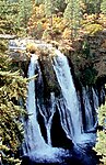
Continuing northwards from Burney, the byway goes past McArthur–Burney Falls Memorial State Park, then Lake Britton, then crosses the McCloud River and runs past Bartle before arriving at McCloud. The byway splits at Bartle; there is an alternate route that runs in a northeasterly direction for 46-mile (74 km) through the Modoc National Forest, winding past Medicine Lake before arriving at Lava Beds National Monument. From Lava Beds National Monument the alternate route runs north for roughly 18-mile (29 km), passing through Tule Lake National Wildlife Refuge.
Region 7: McCloud to Weed[edit]
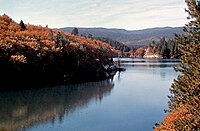
From McCloud, the byway goes past Mount Shasta, then through Black Butte before arriving at Weed. Lake Siskiyou is located just west of the byway, while Mount Shasta is to the west.
Region 8: Weed to Dorris to Tulelake[edit]
Continuing northwards from Weed, the byway goes past Carrick, then Pluto's Cave, Mount Hebron, Macdoel, Butte Valley National Grassland, and Meiss Lake before arriving at Dorris. The byway again splits just north of Dorris; there is an alternate route that runs east for 19-mile (31 km) along the California–Oregon state line on Route 161 past Ainsworth Corner to Hatfield. At Hatfield, Route 161 joins Route 139. From here, the byway continues south for 4-mile (6.4 km) to Tulelake. At this point, Route 139 becomes the Lava Beds Highway while the Volcanic Legacy Scenic Byway turns sharply to the east. 5-mile (8.0 km) east of this point, the byway then turns runs south for roughly 18-mile (29 km), where it passes through Tule Lake National Wildlife Refuge and Lava Beds National Monument. From Lava Beds National Monument, the byway continues south for 46-mile (74 km) through Modoc National Forest, winding past Medicine Lake before arriving at Route 89 in Bartle.
Oregon section[edit]
Region 9: Tulelake to Dorris to Klamath Falls[edit]
From Tulelake, the byway continues east for 5-mile (8.0 km), then turns north and goes past Camp Tulelake before turning west onto Route 161 at Ainsworth Corner. From Ainsworth Corner, the byway continues east on Route 161 for 19-mile (31 km) through Lower Klamath National Wildlife Refuge along the California–Oregon state line, then turns north onto U.S. Route 97 at Dorris. Continuing north, the byway crosses into Oregon at the Francis Landrum Historic Wayside, then passes through Worden (Bear Valley National Wildlife Refuge is located just east of the byway at Worden) and Midland before arriving at Klamath Falls.
Region 10: Klamath Falls to Fort Klamath[edit]
At Klamath Falls, the byway turns onto Oregon Route 140 and heads northeast along the eastern side of Upper Klamath Lake for 25-mile (40 km) before turning north onto Westside Road. From there, the byway passes between Pelican Butte (west of the byway) and Upper Klamath National Wildlife Refuge (east of the byway) before arriving at Fort Klamath.
Region 11: Fort Klamath to Crater Lake National Park[edit]
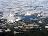
At Fort Klamath, the byway joins Oregon Route 62 and continues north for 16-mile (26 km), where it turns onto Munson Valley Road and enters Crater Lake National Park. At this point, the road becomes Rim Drive, a 33-mile (53 km) loop that follows the caldera rim around Crater Lake. At Merriam Point, Rim Drive splits and turns north. The byway continues north for 9-mile (14 km), crossing the Pumice Desert before turning east onto Oregon Route 138. From this point, the byway continues east for nearly 15-mile (24 km), before finally terminating at U.S. Route 97 in Chemult.
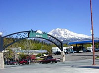
Gallery[edit]
-
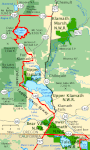
 Map of California section
 -
 Map of Oregon section
 -
-

-

-
-
-

-


.jpg)


See also[edit]
References[edit]
- ^ "The Volcanic Legacy Scenic Byway All-American Road". Yreka, California: Volcanic Legacy Community Partnership. 2020. Retrieved 1 June 2024.
External links[edit]
- All-American Roads
- Crater Lake National Park
- Named highways in California
- Protected areas of Lassen County, California
- Protected areas of Plumas County, California
- Protected areas of Shasta County, California
- Protected areas of Tehama County, California
- Roads in Lassen County, California
- Roads in Plumas County, California
- Roads in Shasta County, California
- Roads in Siskiyou County, California
- Roads in Tehama County, California
- Scenic highways in Oregon
- State Scenic Highway System (California)
- Transportation in Klamath County, Oregon
- U.S. Route 97
- Volcanism of California
- Volcanism of Oregon