
Mýrdalsjökull
| Mýrdalsjökull | |
|---|---|
 Aerial view of Mýrdalsjökull. | |
| Type | Ice cap |
| Location | Southwestern Iceland |
| Area | 520 km2 (200 sq mi)[1] |
| Thickness | Average 230 m (750 ft)[2]: 184 |
| Highest elevation | 1,450 metres (4,760 ft) [2] |
| Terminus | Sléttjökull, Öldufellsjökull, Sandfellsjökull, Kötlujökull, Huldujökull, Mosakambsökull, Klifurárjökull, Sólheimajökull, Jökulsárgilsjökull, Hrunajökull, Tungnakvíslarjökull, Goðalandsjökull, Hrútárökull, and Entujökull [3] |
| Status | Retreating |
 Map of Mýrdalsjökull glacier showing its named glacial catchments (light grey shading with white outline). Clicking on the map to enlarge it enables mouse over that allows identification of individual named glacial catchments in Iceland. | |
Mýrdalsjökull (pronounced [ˈmirˌtalsˌjœːkʏtl̥] , Icelandic for "(the) mire dale glacier" or "(the) mire valley glacier") is an ice cap in the south of Iceland. It is to the north of Vík í Mýrdal and to the east of the smaller ice cap Eyjafjallajökull. Between these two glaciers is the Fimmvörðuháls pass. Its peak ice cover has reached 1,493 m (4,898 ft) in height and in the year 1980 it covered an area of approximately 595 km2 (230 sq mi).[4] In 2016 the covered area of Mýrdalsjökull was believed to be 540 km2 (210 sq mi).[5] The area was 520 km2 (200 sq mi) in 2019.[1] The volume of ice is about 140 km3 (34 cu mi).[2]: 184
Setting[edit]
The icecap of the glacier covers an active volcano called Katla. The caldera of the volcano has a diameter of 10 km (6 mi) and the volcano erupts usually every 40–80 years. The last eruption took place in 1918. Scientists are actively monitoring the volcano, particularly after the eruption of nearby Eyjafjallajökull began in April 2010. Since the year 930, 16 eruptions have been documented and in the last 8400 years about 300 explosive basalt eruptions are known to have originated from Katla.[2]: 184
The glacier covers Katla mountain which while 30–35 km (19–22 mi) in diameter at its base, has a diameter closer to 20 km (12 mi) at 700 m (2,300 ft) elevation. The lowest pass out of the caldera is at 740 m (2,430 ft). This caldera is between 650–750 m (2,130–2,460 ft) deep and is surrounded by a rim of 1,300–1,380 m (4,270–4,530 ft) high mountains.[2]: 184
The Eldgjá, a volcanic eruption fissure about 30 km (19 mi) long, which erupted in the year 939, is part of the same volcanic system.[6]
Before the Hringvegur (the main ring road round the island) was built, people feared traversing the plains in front of the volcano because of the frequent jökulhlaups (glacial floods) and the deep rivers to be crossed, although the road is still vulnerable to major events. Especially dangerous was the glacial flood after the eruption of 1918 when the coastline was extended by 5 km (3.1 mi) by laharic flood deposits.
Mýrdalsjökull is an exceedingly wet location, with models suggesting it receives more than 10 metres of precipitation annually.[7]
Glaciation History[edit]
The last glacial period came to an end 11,500 years ago and was followed by the Holocene. Mýrdalsjökull is likely to have been present throughout the Holocene and definitely the last 8400 years as there is no evidence of degassed erupted tephra from Katla.[2]: 186–7 Jökulhlaup's 8000 to 6000 years ago took a path over the highest pass in the caldera wall which does not support a crater lake source but would happen with an ice cap.[2]: 187
Until the development of remote satellite imaging it was impossible to monitor to annual accuracy the mass balance of Mýrdalsjökull.[8]: 572 Such techniques allowed it to be determined for Mýrdalsjökull that it is the summer temperatures that are the predominant driving factor in the recent recession of the glacier.[8]: 572
-
-
 Mýrdalsjökull
 -
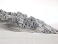 An "ice castle" formation on Mýrdalsjökull
 -
 Mýrdalsjökull glacier covered volcanic ash
 -
 Outlet glacier Sólheimajökull


See also[edit]
- Geography of Iceland
- Glaciers of Iceland
- Iceland plume
- List of lakes in Iceland
- List of islands of Iceland
- List of volcanoes in Iceland
- List of rivers of Iceland
- Volcanism of Iceland
- Waterfalls of Iceland
- List of glaciers
References[edit]
- ^ a b Hannesdóttir, H.; Sigurðsson, O.; Þrastarson, R.H.; Guðmundsson, S.; Belart, J.M.; Pálsson, F.; Magnusson, E.; Víkingsson, S.; Kaldal, I.; Jóhannesson, T. (2020). "A national glacier inventory and variations in glacier extent in Iceland from the Little Ice Age maximum to 2019". Jökull. 12: 1–34. doi:10.33799/jokull2020.70.001.: 2
- ^ a b c d e f g Oladottir, B.A.; Thordarson, T.; Larsen, G.; Sigmarsson, O. (2007). "Survival of the Mýrdalsjökull ice cap through the Holocene thermal maximum: evidence from sulphur contents in Katla tephra layers (Iceland) from the last∽ 8400 years". Annals of Glaciology. 45: 183–188. Bibcode:2007AnGla..45..183O. doi:10.3189/172756407782282516.
- ^ Sigurðsson, Oddur; Williams, Richard S. (2008). "Geographic Names of Iceland's Glaciers:Historic and Modern". In Richard S. Williams Jr.; Jane G. Ferrigno (eds.). Satellite Image Atlas of Glaciers of the World series (U.S. Geological Survey Professional Paper 1386-D (PDF). Retrieved 21 May 2024.
- ^ Humlum, Ole (1985). "Changes in Texture and Fabric of Particles in Glacial Traction with Distance from Source, Mỳrdalsjökull, Iceland". Journal of Glaciology. 31 (108): 150–156. doi:10.1017/S0022143000006390. ISSN 0022-1430.
- ^ Björnsson, Helgi (2017), Björnsson, Helgi (ed.), "Glaciers of Southern Iceland", The Glaciers of Iceland: A Historical, Cultural and Scientific Overview, Paris: Atlantis Press, pp. 211–273, doi:10.2991/978-94-6239-207-6_5, ISBN 978-94-6239-207-6, retrieved 2024-04-26
- ^ Moreland, William Michael; Thordarson, Thor; Houghton, Bruce F.; Larsen, Gudrún (28 August 2019). "Driving mechanisms of subaerial and subglacial explosive episodes during the 10th century Eldgjá fissure eruption, southern Iceland". Volcanica. 2 (2): 129–150. doi:10.30909/vol.02.02.129150. ISSN 2610-3540. S2CID 202923626.
- ^ "Late Holocene Glacial History of Sólheimajökull, Southern Iceland" (PDF). Archived from the original (PDF) on 2014-03-20.
- ^ a b Jaenicke, J.; Mayer, C.; Scharrer, K.; Münzer, U.; Gudmundsson, A. (2006). "The use of remote-sensing data for mass-balance studies at Mýrdalsjökull ice cap, Iceland". Journal of Glaciology. 52 (179): 565–573. Bibcode:2006JGlac..52..565J. doi:10.3189/172756506781828340.
External links[edit]
- http://www.nimbus.it/glaciorisk/Glacier_view.asp?IdGlacier=3965&Vista=paese&Paese=Iceland&IdTipoRischio= (Details of all known Glacier Runs from Mýrdalsjökull)
- http://isafold.de/strutstigur02/img_jokull.htm (Photo of Mýrdalsjökull)
- https://web.archive.org/web/20040504154433/http://volcano.und.edu/vwdocs/volc_images/europe_west_asia/eldgja.html (Volcanism)
- Katla: eruption preparedness for tourists