
File:A chart of the WESTERN part of the EAST-INDIES with all the adjacent Islands from cape Bona Esperanca to the Island of Zelone NYPL1640657.tiff

Size of this JPG preview of this TIF file: 799 × 600 pixels. Other resolutions: 320 × 240 pixels | 640 × 480 pixels | 1,023 × 768 pixels | 1,280 × 961 pixels | 2,560 × 1,922 pixels | 7,230 × 5,428 pixels.
Original file (7,230 × 5,428 pixels, file size: 112.28 MB, MIME type: image/tiff)
| This is a file from the Wikimedia Commons. Information from its description page there is shown below. Commons is a freely licensed media file repository. You can help. |
Summary
| Description | A chart of the WESTERN part of the EAST-INDIES with all the adjacent Islands from cape Bona Esperanca to the Island of Zelone; Atlases, gazetteers, guidebooks and other books / The sea-atlas : containing an hydrographical description of most of the sea-coasts of the known parts of the world. | |||||||||||||||||||||||
| Catalogue call number | Map Div. 02-295 | |||||||||||||||||||||||
| Item/Page/Plate | 135 | |||||||||||||||||||||||
| Standard reference | Sabin 95631 | |||||||||||||||||||||||
| Date | between circa 1702 and circa 1707 | |||||||||||||||||||||||
| Source |
http://digitalgallery.nypl.org/nypldigital/dgkeysearchdetail.cfm?imageID=1640657
|
|||||||||||||||||||||||
| Author | Thornton, Samuel -- Cartographer | |||||||||||||||||||||||
| Permission (Reusing this file) |
From The Lionel Pincus and Princess Firyal Map Division. http://maps.nypl.org
|
|||||||||||||||||||||||
| Source description | 1 v. in 2 : maps ; 53 cm. | |||||||||||||||||||||||
| Location | Stephen A. Schwarzman Building / The Lionel Pincus and Princess Firyal Map Division | |||||||||||||||||||||||
| Digital item published | 6-25-2008; updated 3-25-2011 | |||||||||||||||||||||||
| Digital ID | 1640657 | |||||||||||||||||||||||

The making of this file was supported by Wikimedia UK.
To see other files made with the support of Wikimedia UK, please see the category Supported by Wikimedia UK.
|
File history
Click on a date/time to view the file as it appeared at that time.
| Date/Time | Thumbnail | Dimensions | User | Comment | |
|---|---|---|---|---|---|
| current | 08:21, 20 April 2014 | 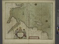 | 7,230 × 5,428 (112.28 MB) | Fæ | GWToolset:: Creating mediafile for Fæ. Tranche 2.389 |
File usage
The following pages on the English Wikipedia use this file (pages on other projects are not listed):
Global file usage
The following other wikis use this file:
- Usage on la.wikipedia.org
- Usage on mk.wikipedia.org
- Usage on sr.wikipedia.org