
Portal:World
The World Portal


The world is the totality of entities, the whole of reality, or everything that exists. The nature of the world has been conceptualized differently in different fields. Some conceptions see the world as unique while others talk of a "plurality of worlds". Some treat the world as one simple object while others analyze the world as a complex made up of parts.
In scientific cosmology, the world or universe is commonly defined as "[t]he totality of all space and time; all that is, has been, and will be". Theories of modality talk of possible worlds as complete and consistent ways how things could have been. Phenomenology, starting from the horizon of co-given objects present in the periphery of every experience, defines the world as the biggest horizon or the "horizon of all horizons". In philosophy of mind, the world is contrasted with the mind as that which is represented by the mind. Theology conceptualizes the world in relation to God, for example, as God's creation, as identical to God or as the two being interdependent. In religions, there is a tendency to downgrade the material or sensory world in favor of a spiritual world to be sought through religious practice. A comprehensive representation of the world and our place in it, as is found in religions, is known as a worldview. Cosmogony is the field that studies the origin or creation of the world while eschatology refers to the science or doctrine of the last things or of the end of the world.
In various contexts, the term "world" takes a more restricted meaning associated, for example, with the Earth and all life on it, with humanity as a whole or with an international or intercontinental scope. In this sense, world history refers to the history of humanity as a whole and world politics is the discipline of political science studying issues that transcend nations and continents. Other examples include terms such as "world religion", "world language", "world government", "world war", "world population", "world economy", or "world championship". (Full article...)
Selected articles -
-

The World Wide Web ("WWW", "W3" or simply "the Web") is a global information medium that users can access via computers connected to the Internet. The term is often mistakenly used as a synonym for the Internet, but the Web is a service that operates over the Internet, just as email and Usenet do. The history of the Internet and the history of hypertext date back significantly further than that of the World Wide Web.
Tim Berners-Lee invented the World Wide Web while working at CERN in 1989. He proposed a "universal linked information system" using several concepts and technologies, the most fundamental of which was the connections that existed between information. He developed the first web server, the first web browser, and a document formatting protocol, called Hypertext Markup Language (HTML). After publishing the markup language in 1991, and releasing the browser source code for public use in 1993, many other web browsers were soon developed, with Marc Andreessen's Mosaic (later Netscape Navigator), being particularly easy to use and install, and often credited with sparking the Internet boom of the 1990s. It was a graphical browser which ran on several popular office and home computers, bringing multimedia content to non-technical users by including images and text on the same page. (Full article...) -
A global city, also known as a power city, world city, alpha city, or world center, is a city that serves as a primary node in the global economic network. The concept originates from geography and urban studies, based on the thesis that globalization has created a hierarchy of strategic geographic locations with varying degrees of influence over finance, trade, and culture worldwide. The global city represents the most complex and significant hub within the international system, characterized by links binding it to other cities that have direct, tangible effects on global socioeconomic affairs.
The criteria of a global city have varied over time. Depending on the source, common features include a high degree of urban development, a large population, the presence of major multinational companies, a significant and globalized financial sector, a well-developed and internationally linked transportation infrastructure, local or national economic dominance, high quality educational and research institutions, and a globally influential output of ideas, innovations, or cultural products. Quintessential examples, based on most indices and research, include New York City, London, Paris, and Tokyo. (Full article...) -
The term "new world order" refers to a new period of history evidencing dramatic change in world political thought and the balance of power in international relations. Despite varied interpretations of this term, it is commonly associated with the notion of world governance.
The phrase "new world order" or similar language was used in the period toward the end of the First World War in relation to Woodrow Wilson's vision for international peace; Wilson called for a League of Nations to prevent aggression and conflict. In some instances when Franklin D. Roosevelt used the phrase "new world order", or "new order in the world" it was to refer to Axis powers plans for world domination. Although Roosevelt and Harry S. Truman may have been hesitant to use the phrase, commentators have applied the term retroactively to the order put in place by the World War II victors including the United Nations and the Bretton Woods system as a "new world order." (Full article...) -

The World Bank Group (WBG) is a family of five international organizations that make leveraged loans to developing countries. It is the largest and best-known development bank in the world and an observer at the United Nations Development Group. The bank is headquartered in Washington, D.C., in the United States. It provided around $98.83 billion in loans and assistance to "developing" and transition countries in the 2021 fiscal year. The bank's stated mission is to achieve the twin goals of ending extreme poverty and building shared prosperity. Total lending as of 2015 for the last 10 years through Development Policy Financing was approximately $117 billion. Its five organizations are- the International Bank for Reconstruction and Development (IBRD),
- the International Development Association (IDA),
- the International Finance Corporation (IFC),
- the Multilateral Investment Guarantee Agency (MIGA) and
- the International Centre for Settlement of Investment Disputes (ICSID).
-
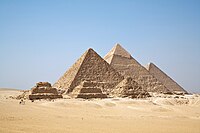
Among the various cradles of civilization is Ancient Egypt. Pictured are the Giza Pyramids.
A cradle of civilization is a location and a culture where civilization was developed independent of other civilizations in other locations. The formation of urban settlements (cities) is the primary characteristic of a society that can be characterized as "civilized". Other characteristics of civilization include a sedentary non-nomadic population, monumental architecture, the existence of social classes and inequality, and the creation of a writing system for communication. The transition from simpler societies to the complex society of a civilization is gradual.
Scholars generally acknowledge six cradles of civilization: Mesopotamia, Ancient Egypt, Ancient India, and Ancient China are believed to be the earliest in Afro-Eurasia (previously called the Old World), while the Caral-Supe civilization of coastal Peru and the Olmec civilization of Mexico are believed to be the earliest in Americas - previously known in Western literature as the New World. All of the cradles of civilization depended upon agriculture for sustenance (except possibly Caral-Supe which may have depended initially on marine resources). All depended upon farmers producing an agricultural surplus to support the centralized government, political leaders, priests, and public works of the urban centers of the early civilizations. (Full article...) -

Second preliminary session of the World Summit Information Society, plenary meeting, 18–25 February 2005, UN building, Geneva, Switzerland.
The World Summit on the Information Society (WSIS) was a two-phase United Nations-sponsored summit on information, communication and, in broad terms, the information society that took place in 2003 in Geneva and in 2005 in Tunis. WSIS Forums have taken place periodically since then. One of the Summit's chief aims is to bridge the global digital divide separating rich countries from poor countries by increasing internet accessibility in the developing world. The conferences established 17 May as World Information Society Day.
The WSIS+10 Process marked the ten-year milestone since the 2005 Summit. In 2015, the stocktaking process culminated with a High-Level meeting of the UN General Assembly on 15 and 16 December in New York. (Full article...) -
The Space Age is a period encompassing the activities related to the space race, space exploration, space technology, and the cultural developments influenced by these events, beginning with the launch of Sputnik 1 on October 4, 1957, and continuing to the present.
This period is characterized by changes in emphasis on particular areas of space exploration and applications. Initially, the United States and the Soviet Union invested unprecedented amounts of resources in breaking records and being first to meet milestones in crewed and uncrewed exploration. The United States established the National Aeronautics and Space Administration (NASA) and the USSR established the Kosmicheskaya programma SSSR to meet these goals. This period of competition gave way to cooperation between those nations and emphasis on scientific research and commercial applications of space-based technology. (Full article...)

.jpg)


General images -
-
 A reconstruction of Pannotia (550 Ma). (from History of Earth)
 -
 Tiktaalik, a fish with limb-like fins and a predecessor of tetrapods. Reconstruction from fossils about 375 million years old. (from History of Earth)
 -
 Last Moon landing: Apollo 17 (1972)
 -

-
 Taj Mahal, Mughal Empire, India
 -
 Earth's western hemisphere showing topography relative to Earth's center instead of to mean sea level, as in common topographic maps (from Earth)
 -

-
 Artist's impression of a Hadean landscape with the relatively newly formed Moon still looming closely over Earth and both bodies sustaining strong volcanism. (from History of Earth)
 -
 Standing Buddha from Gandhara, 2nd century CE
 -
 An artist's impression of ice age Earth at glacial maximum. (from History of Earth)
 -
 "Lucy", the first Australopithecus afarensis skeleton found. Lucy was only 1.06 m (3 ft 6 in) tall.
 -
 The pale orange dot, an artist's impression of the early Earth which might have appeared orange through its hazy methane rich prebiotic second atmosphere. Earth's atmosphere at this stage was somewhat comparable to today's atmosphere of Titan. (from History of Earth)
 -
 Machu Picchu, Inca Empire, Peru
 -

-
 Persepolis, Achaemenid Empire, 6th century BCE
 -

-
 Cross-section through a liposome (from History of Earth)
 -
 An animation of the changing density of productive vegetation on land (low in brown; heavy in dark green) and phytoplankton at the ocean surface (low in purple; high in yellow) (from Earth)
 -
 A banded iron formation from the 3.15 Ga Moodies Group, Barberton Greenstone Belt, South Africa. Red layers represent the times when oxygen was available; gray layers were formed in anoxic circumstances. (from History of Earth)
 -
 A composite image of Earth, with its different types of surface discernible: Earth's surface dominating Ocean (blue), Africa with lush (green) to dry (brown) land and Earth's polar ice in the form of Antarctic sea ice (grey) covering the Antarctic or Southern Ocean and the Antarctic ice sheet (white) covering Antarctica. (from Earth)
 -
 Earth's axial tilt causing different angles of seasonal illumination at different orbital positions around the Sun (from Earth)
 -

-
 A schematic view of Earth's magnetosphere with solar wind flowing from left to right (from Earth)
 -
 Shanghai. China urbanized rapidly in the 21st century.
 -
 Florence, birthplace of the Italian Renaissance
 -
 Artist's impression of the enormous collision that probably formed the Moon (from History of Earth)
 -
 A computer-generated image mapping the prevalence of artificial satellites and space debris around Earth in geosynchronous and low Earth orbit (from Earth)
 -
 Dinosaurs were the dominant terrestrial vertebrates throughout most of the Mesozoic (from History of Earth)
 -
 Trilobites first appeared during the Cambrian period and were among the most widespread and diverse groups of Paleozoic organisms. (from History of Earth)
 -

-
 Chloroplasts in the cells of a moss (from History of Earth)
 -

-
 Fall of the Berlin Wall, 1989
 -

-

-
 A map of heat flow from Earth's interior to the surface of Earth's crust, mostly along the oceanic ridges (from Earth)
 -

-
 A 2012 artistic impression of the early Solar System's protoplanetary disk from which Earth and other Solar System bodies were formed (from Earth)
 -
 Notre-Dame de Paris, France
 -
 Geologic map of North America, color-coded by age. From most recent to oldest, age is indicated by yellow, green, blue, and red. The reds and pinks indicate rock from the Archean.
 -
 An artist's rendering of a protoplanetary disk (from History of Earth)
 -
 Obelisk of Axum, Ethiopia
 -
 An artist's impression of the Archean, the eon after Earth's formation, featuring round stromatolites, which are early oxygen-producing forms of life from billions of years ago. After the Late Heavy Bombardment, Earth's crust had cooled, its water-rich barren surface is marked by continents and volcanoes, with the Moon still orbiting Earth half as far as it is today, appearing 2.8 times larger and producing strong tides. (from Earth)
 -
 Tracy Caldwell Dyson, a NASA astronaut, observing Earth from the Cupola module at the International Space Station on 11 September 2010 (from Earth)
 -
 Ming dynasty section, Great Wall of China
 -
 Great Pyramids of Giza, Egypt
 -
 Earth's history with time-spans of the eons to scale (from History of Earth)
 -
Artist's impression of Earth during the later Archean, the largely cooled planetary crust and water-rich barren surface, marked by volcanoes and continents, features already round microbialites. The Moon, still orbiting Earth much closer than today and still dominating Earth's sky, produced strong tides. (from History of Earth)
-
 Empires of the world in 1898
 -
 Olmec colossal head, now at the Museo de Antropología de Xalapa
 -
 Vitruvian Man by Leonardo da Vinci epitomizes the advances in art and science seen during the Renaissance. (from History of Earth)
 -
 Chennakesava Temple, Belur, India
 -
 Map of peopling of the world (Southern Dispersal paradigm), in thousands of years ago.
 -
 Earth's land use for human agriculture in 2019 (from Earth)
 -
 Ajloun Castle, Jordan
 -
 Artist's conception of Devonian flora (from History of Earth)
 -
 The replicator in virtually all known life is deoxyribonucleic acid. DNA is far more complex than the original replicator and its replication systems are highly elaborate. (from History of Earth)
 -
 Artist's rendition of an oxinated fully-frozen Snowball Earth with no remaining liquid surface water. (from History of Earth)
 -
 Pangaea was a supercontinent that existed from about 300 to 180 Ma. The outlines of the modern continents and other landmasses are indicated on this map. (from History of Earth)
 -
 Satellite time lapse imagery of Earth's rotation showing axis tilt (from Earth)
 -
 A view of Earth with different layers of its atmosphere visible: the troposphere with its clouds casting shadows, a band of stratospheric blue sky at the horizon, and a line of green airglow of the lower thermosphere around an altitude of 100 km, at the edge of space (from Earth)
 -
 Japanese depiction of a Portuguese carrack. European maritime innovations led to proto-globalization.
 -
 Great Mosque of Kairouan, Tunisia, founded 670 CE
 -
 A pillar at Göbekli Tepe
 -
 Angkor Wat temple complex, Cambodia, early 12th century
 -
 View of Earth from the Moon by the Lunar Reconnaissance Orbiter (from Earth)
 -

-

-
 The Pantheon, originally a Roman temple, now a Catholic church
 -

-
 First airplane, the Wright Flyer, flew on 17 December 1903.
 -
 A Benin Bronze head from Nigeria
 -
 Lithified stromatolites on the shores of Lake Thetis, Western Australia. Archean stromatolites are the first direct fossil traces of life on Earth. (from History of Earth)
 -
 Battle during the 1281 Mongol invasion of Japan
 -
 A 580 million year old fossil of Spriggina floundensi, an animal from the Ediacaran period. Such life forms could have been ancestors to the many new forms that originated in the Cambrian Explosion. (from History of Earth)
 -
Pale orange dot, an artist's impression of Early Earth, featuring its tinted orange methane-rich early atmosphere (from Earth)
-

-
 Image of the physical world, captured by the Hubble Space Telescope (from World)
 -
 A composite image of artificial light emissions at night on a map of Earth (from Earth)
 -
 A reconstruction of human history based on fossil data. (from History of Earth)
 -
 A view of Earth with its global ocean and cloud cover, which dominate Earth's surface and hydrosphere; at Earth's polar regions, its hydrosphere forms larger areas of ice cover. (from Earth)
 -

-

-
 Artist's conception of Hadean Eon Earth, when it was much hotter and inhospitable to all forms of life. (from History of Earth)
 -
 Graph showing range of estimated partial pressure of atmospheric oxygen through geologic time (from History of Earth)
 -

-
 Yggdrasil, an attempt to reconstruct the Norse world tree which connects the heavens, the world, and the underworld. (from World)
 -
 Change in average surface air temperature and drivers for that change. Human activity has caused increased temperatures, with natural forces adding some variability. (from Earth)
 -

-
 Earth's night-side upper atmosphere appearing from the bottom as bands of afterglow illuminating the troposphere in orange with silhouettes of clouds, and the stratosphere in white and blue. Next the mesosphere (pink area) extends to the orange and faintly green line of the lowest airglow, at about one hundred kilometers at the edge of space and the lower edge of the thermosphere (invisible). Continuing with green and red bands of aurorae stretching over several hundred kilometers. (from Earth)
 -


.jpeg)


.jpg)


.svg)


.jpg)


.jpg)


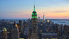
Megacities of the world -
.jpg)
Buenos Aires (/ˌbweɪnəs ˈɛəriːz/ or /-ˈaɪrɪs/; Spanish pronunciation: [ˈbwenos ˈajɾes] ), officially the Autonomous City of Buenos Aires, is the capital and primate city of Argentina. The city is located on the western shore of the Río de la Plata, on South America's southeastern coast. "Buenos aires" is Spanish for "fair winds" or "good airs". Buenos Aires is classified as an Alpha global city, according to the Globalization and World Cities Research Network (GaWC) 2020 ranking.
The city of Buenos Aires is neither part of Buenos Aires Province nor the Province's capital; rather, it is an autonomous district. In 1880, after decades of political infighting, Buenos Aires was federalized and removed from Buenos Aires Province. The city limits were enlarged to include the towns of Belgrano and Flores; both are now neighborhoods of the city. The 1994 constitutional amendment granted the city autonomy, hence its formal name of Autonomous City of Buenos Aires. Its citizens first elected a Chief of Government in 1996; previously, the Mayor was directly appointed by the President of Argentina. (Full article...)Did you know -

- ... that the McLaren MCL36, McLaren's 2022 Formula One car, has been in development since 2019 because of the pandemic's interruptions to the sport?
- ... that Chicago's Kasama is the world's first Filipino restaurant to be awarded a Michelin star?
- ... that, after her death, contemporaries of Frankish queen Austregilde both called her "the light of her homeland, the world, and the court" and compared her to Herod?
- ... that the Bush Tower, near New York City's Times Square, was an attempt at a trade center before the World Trade Center itself?
- ... that the Jewish anarchist Volin refused to flee Nazi-occupied France as he believed that a revolution would follow the liberation of France?
- ... that after becoming paralyzed from the neck down, Rocky "RockyNoHands" Stoutenburgh broke two Guinness World Records in the video game Fortnite?
- ... that almost 40 years into their career, American indie rock band Yo La Tengo released their first self-produced album, This Stupid World, in 2023?
- ... that the world's only museum devoted to American actor Phil Silvers is located in Coventry, England?
Countries of the world -

Micronesia (UK: /ˌmaɪkrəˈniːziə/, US: /-ˈniːʒə/) is a subregion of Oceania, consisting of about 2,000 small islands in the Northwestern Pacific Ocean. It has a close shared cultural history with three other island regions: Maritime Southeast Asia to the west, Polynesia to the east, and Melanesia to the south—as well as with the wider community of Austronesian peoples.
The region has a tropical marine climate and is part of the Oceanian realm. It includes four main archipelagos—the Caroline Islands, the Gilbert Islands, the Mariana Islands, and the Marshall Islands — as well as numerous islands that are not part of any archipelago. (Full article...)Related portals
Protected areas of the world -
-
Papua New Guinea is home to several protected areas, which receive protection because of their environmental, cultural or similar value.
The total area of Papua New Guinea protected territories is 14,330 km2 (5,530 sq mi), which amounts to approximately 3.07% of the country's territory. The total number of protected areas as 2018 is 71. (Full article...) -
Protected areas of Turkmenistan include nine nature reserves (zapovednik) and 13 sanctuaries (zakaznik) with a total area of 19,750 km2 or more than 4% of Turkmenistan's territory. (Full article...)
-
This is a list of protected areas of Saudi Arabia, some of which are managed by the Saudi Wildlife Authority.:
- At-Taysiyah Protected Area
- Jabal Shada Nature Reserve
- Majami'al-Hadb Protected Area
- Nafud al-'Urayq
- Raydah Natural Reserve
- 'Uruq Bani Ma'arid
- Saja Umm Ar-Rimth Natural Reserve
- Harrat al-Harrah Protected Area
- Al-Khunfah Natural Reserve
- Ibex Reserve Protected Area
- Mahazat as-Sayd Protected Area
- Umm al-Qamari Islands
- Al-Tubayq Natural Reserve
- Farasan Islands Protected Area
- Jubail Marine Wildlife Sanctuary
- Jabal Aja Protected Area
- Wadi Turabah Nature Reserve
-
There are four categories of protected areas in India, constituted under the Wildlife Protection Act, 1972. Tiger reserves consist of areas under national parks and wildlife sanctuaries. There are 53 tiger reserves in India. the protected areas of India cover 173,629.52 square kilometres (67,038.73 sq mi), roughly 5.28% of the total geographical area of the country. (Full article...)
-
The Protected areas of Kyrgyzstan are regulated by the law on specially protected natural areas of 2 May 2011, last modified on 2 June 2018. In total, they cover 14,761.216 km2 (5,699.337 sq mi) and account for 7.38% of the country's total area (as of 2017). The first protected area in Kyrgyzstan (Issyk-Kul) was established in 1948. According to the Government Decree on Priorities of Conservation of Biological Diversity and the relevant Action Plan for 2014-2024 the target area for the protected areas in Kyrgyzstan is 10 percent of the country’s area by 2024.
The protected areas are subdivided into seven categories: (Full article...) -
Protected areas of Canada consist of approximately 12.1 percent of the nation's landmass and freshwater are considered conservation areas, including 11.4 percent designated as protected areas. Approximately 13.8 percent of Canada's territorial waters are conserved, including 8.9 percent designated as protected areas. Terrestrial areas conserved have increased by 65 percent in the 21st century, while marine areas conserved have increased by more than 3,800 percent.
Conservation and protected areas have different mandates depending on the organization which manages them, with some areas having a greater focus on ecological integrity, historical preservation, public usage, scientific research, or a combination of usages. Some areas such as the Polar Bear Pass, are co-managed and overseen by government and local indigenous agencies. (Full article...) -
Protected areas of Tasmania consist of protected areas located within Tasmania and its immediate onshore waters, including Macquarie Island. It includes areas of crown land (withheld land) managed by Tasmanian Government agencies as well as private reserves. As of 2016, 52% of Tasmania's land area has some form of reservation classification, the majority is managed by the Tasmania Parks & Wildlife Service (about 42% of total Tasmanian land area). Marine protected areas cover about 7.9% of state waters.
Within each classification of reserve there may be a variation of IUCN categories Australia is a signatory to the Convention of Biological Diversity and as such has obligations to report the status of its National Reserve System.IUCN provides on its website a prescription for activities consistent with the categorisation system. Changes made to the Nature Conservation Act 2002 in 2014 permit timber harvesting. These changes made in addition to the already established right to access minerals means that many of the IUCN categorisations assigned to individual reserves in Tasmania are no longer fit for purpose. In addition many reserves have had their reserve status downgraded from a class excluding timber harvesting and mineral extraction to ones where these activities are now permitted. This mis-application of the IUCN protected area categories needs to be remedied or the reserves protected land class under the Nature Conservation Act 2002 should be adjusted to reflect its currently assigned IUCN category. (Full article...) -

Tijuca Forest National Park
Protected areas of Brazil included various classes of area according to the National System of Nature Conservation Units (SNUC), a formal, unified system for federal, state and municipal parks created in 2000. (Full article...) -
-

Total size of protected area of Bosnia and Herzegovina amounts of 57.83694 hectares (142.9182 acres), which is 1,13% of its entire territory. This is a list of areas protected by corresponding levels of the government of Bosnia and Herzegovina, namely at the entity's levels, and with various categorizations. (Full article...) -
Protected areas of Slovenia include one national park (Slovene: narodni park), three regional parks (regijski park), several natural parks (krajinski park), and hundreds of natural monuments (naravni spomenik) and monuments of designed nature (spomenik oblikovane narave). They cover about 12.5% of the Slovenian territory. Under the Wild Birds Directive, 26 sites totalling roughly 25% of the nation's land are "Special Protected Areas"; the Natura 2000 proposal would increase the totals to 260 sites and 32% of national territory. (Full article...)
-

Cape Spencer Lighthouse, Innes National Park
Protected areas of South Australia, consisting of protected areas located within South Australia and its immediate onshore waters and which are managed by South Australian Government agencies. As of 2018, South Australia contained 359 separate protected areas declared under the National Parks and Wildlife Act 1972, the Crown Land Management Act 2009 and the Wilderness Protection Act 1992. Together, they cover a total land area of 211,387.48 km2 (81,617.16 sq mi) or 21.5% of the state's area. (Full article...) -
A list of protected areas of Oman:
- Al Wusta Wildlife Reserve
- Ra's Al Hadd Turtle Reserve
- Ad Dimaniyat Islands Reserve
- Al Saleel National Park (As Salil Natural Park)
- Jabal Samhan Nature Reserve
- Al Jabal Al Akhdar Scenic Reserve
- Western Hajer Stars Lights Reserve
- Arabian Oryx Sanctuary
- Al Rustaq Wildlife Reserve
- Al Wusta Wetland Reserve
- Jabal Qahwan Nature Reserve
- Al Sareen Nature Reserve
- Ras al Shajar Nature Reserve
- Al Khuwuair Nature Reserve
- Khawrs of the Salalah Coast Reserve
-
-
Queensland is the second largest state in Australia. As at 2020, it contained more than 1000 protected areas. In August 2023, it was estimated a total of 14.5 million hectares or 8.38% of Queensland's landmass was protected. (Full article...)


Selected world maps
-
 United Nations Human Development Index map by country (2016)
 -
 1516 map of the world by Martin Waldseemüller
 -
 Time zones of the world
 -
 Index map from the International Map of the World (1:1,000,000 scale)
 -
 Only a few of the largest large igneous provinces appear (coloured dark purple) on this geological map, which depicts crustal geologic provinces as seen in seismic refraction data
 -
 A plate tectonics map with volcano locations indicated with red circles
 -
 The world map by Gerardus Mercator (1569), the first map in the well-known Mercator projection
 -
 The Goode homolosine projection is a pseudocylindrical, equal-area, composite map projection used for world maps.
 -
 Mollweide projection of the world


World records
- List of Olympic records in athletics
- List of world records in athletics
- List of junior world records in athletics
- List of world records in masters athletics
- List of world youth bests in athletics
- List of IPC world records in athletics
- List of world records in canoeing
- List of world records in chess
- List of cycling records
- List of world records in track cycling
- List of world records in finswimming
- List of world records in juggling
- List of world records in rowing
- List of world records in speed skating
- List of world records in swimming
- List of IPC world records in swimming
- List of world records in Olympic weightlifting
Topics

Continents of Earth | ||||||||
|---|---|---|---|---|---|---|---|---|
| ||||||||
| ||||||||
| ||||||||


| Cenozoic Era (present–66.0 Ma) |
| ||||||||||||
|---|---|---|---|---|---|---|---|---|---|---|---|---|---|
| Mesozoic Era (66.0–252 Ma) |
| ||||||||||||
| Paleozoic Era (252–539 Ma) |
| ||||||||||||
| Proterozoic Eon (539 Ma–2.5 Ga) |
| ||||||||||||
| Archean Eon (2.5–4 Ga) | |||||||||||||
| Hadean Eon (4–4.6 Ga) | |||||||||||||
ka = kiloannum (thousands years ago); Ma = megaannum (millions years ago); Ga = gigaannum (billions years ago). See also: Geologic time scale • | |||||||||||||
| Locations | ||
|---|---|---|
| Related | ||

| |||||||||||||||||||
| |||||||||||||||||||
| |||||||||||||||||||

Economic classification of countries | |||||
|---|---|---|---|---|---|
| Three-World Model | |||||
| Gross domestic product (GDP) |
| ||||
| Gross national income (GNI) | |||||
| Wages | |||||
| Wealth | |||||
| Other national accounts | |||||
| Human development | |||||
| Digital divide | |||||
| Net international investment position (NIIP) | |||||
| Technological |
| ||||
|---|---|---|---|---|---|
| Sociological | |||||
| Ecological |
| ||||
| Biological |
| ||||
| Astronomical | |||||
| Eschatological |
| ||||
| Others |
| ||||
| Fictional | |||||
| Organizations | |||||
Categories

Wikimedia
The following Wikimedia Foundation sister projects provide more on this subject:
-
 Commons
Free media repository -
 Wikibooks
Free textbooks and manuals -
 Wikidata
Free knowledge base -
 Wikinews
Free-content news -
 Wikiquote
Collection of quotations -
 Wikisource
Free-content library -
 Wikispecies
Directory of species -
 Wikiversity
Free learning tools -
 Wikivoyage
Free travel guide -
 Wiktionary
Dictionary and thesaurus


