Within the New York City metropolitan area, the airport system—which includes John F. Kennedy International Airport, LaGuardia Airport, Newark Liberty International Airport (located in New Jersey), Stewart Airport and a few smaller facilities—is one of the largest in the world. The Port of New York and New Jersey, which includes the waterways around New York City and its metropolitan area, is one of the busiest seaports in the United States. There are also three commuter rail systems, the PATH rapid transit system to New Jersey, and various ferries between Manhattan and New Jersey. Numerous separate bus systems also operate to Westchester County, Nassau County, and New Jersey. For private vehicles, a system of expressways and parkways connects New York City with its suburbs.
Eurostar is a high-speed railway service connecting London with Paris and Brussels. All its trains traverse the Channel Tunnel between the United Kingdom and France, owned and operated separately by Eurotunnel.
The service is operated by eighteen-coach Class 373/1 trains which run at up to 300 kilometres per hour (186 mph) on a network of high-speed lines. The LGV Nord line in France opened before Eurostar services began in 1994, and newer lines enabling faster journeys were added later—HSL 1 in Belgium and High Speed 1 in southern England. The French and Belgian parts of the network are shared with Paris–Brussels Thalys services and also with TGV trains. In the United Kingdom the two-stage Channel Tunnel Rail Link project was completed on 14 November 2007 and renamed High Speed 1, when the London terminus of Eurostar transferred from Waterloo International to St Pancras International. (Full article...)
Sir Charles Herbert BresseyCB, CBE (3 January 1874 – 14 April 1951) was a civil engineer and surveyor who specialised in road design. Bressey was Chief Engineer for Roads at the Ministry of Transport from 1921 to 1938. Between 1935 and 1938 he carried out research on road planning and motorway design in preparation for his Highway Development Survey, 1937 for Greater London published in 1938. He served as President of the Institution of Chartered Surveyors in 1938-9.
During World War I, Bressey served in the Royal Engineers and spent time in France and Flanders constructing military roads attaining the rank of Lieutenant-Colonel before he left the army in November 1919, when he joined the Ministry of Transport. His 1938 report proposed a series of high capacity motorways radiating outwards from the city and made recommendations for a series of circular routes around the capital and major road improvements in the central area, including tunnels under Kensington Gardens, Victoria Park and Islington High Street and a viaduct from Rotherhithe to Forest Hill. Although World War II delayed the implementation of any of the recommendations, they were subsequently featured in a number of post war reports such as Sir Patrick Abercrombie's County of London Plan and the Greater London Council's 1960s London Ringways scheme and were the origins of plans that were later combined to create London's orbital motorway, the M25. (Full article...)
Image 1The multi-level junction between the M23 and M25 motorways near Merstham in Surrey. The M23 passes over the M25 with bridges carrying interchange slip roads for the two motorways in between.
Image 15Arguably the best-preserved disused station building in London, this is the former Alexandra Palace station on the GNR Highgate branch (closed in 1954). It is now in use as a community centre (CUFOS).
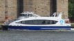
Image 16Rail, road and river traffic, seen from the London Eye.
Image 37Sailing ships at West India Docks on the Isle of Dogs in 1810. The docks opened in 1802 and closed in 1980 and have since been redeveloped as the Canary Wharf development.
Image 44London Underground A60 Stock (left) and 1938 Stock (right) trains showing the difference in the sizes of the two types of rolling stock operated on the system. A60 stock trains operated on the surface and sub-surface sections of the Metropolitan line from 1961 to 2012 and 1938 Stock operated on various deep level tube lines from 1938 to 1988.
Image 46The newly constructed junction of the Westway (A40) and the West Cross Route (A3220) at White City, circa 1970. Continuation of the West Cross Route northwards under the roundabout was cancelled leaving two short unused stubs for the slip roads that would have been provided for traffic joining or leaving the northern section.


,_Showbus_2012_rally.jpg)


_engraving.jpg)

_building.JPG)


_(geograph_4758436).jpg)
.jpg)


_2011_New_Bus_for_London,_Victoria,_route_38,_27_February_2012.jpg)
.jpg)


.jpg)

_Railway_Poster,_1905.png)


.jpg)