
Enipeus Vallis: Difference between revisions
m Fixed header Reference => References (Build J2) |
m Format plain DOIs using AWB (7927) |
||
| Line 13: | Line 13: | ||
|naming= |
|naming= |
||
}} |
}} |
||
'''Enipeus Vallis''' is a valley in the northern hemisphere of the planet [[Mars]]. It is centered at lat. 37°N, long. 267°E in the [[Arcadia quadrangle]] (MC-3) between the large volcano [[Alba Mons]] and the [[Tempe Terra]] plateau. The valley follows a gently [[sinuosity|sinuous]], north-south path for a distance of about 357 km (222 mi).<ref name=GPN>USGS Gazetteer of Planetary Nomenclature. http://planetarynames.wr.usgs.gov/Feature/1803.</ref> It is likely an ancient [[watercourse]] that formed during the early [[Geology of Mars#Crater density timescale|Hesperian]] (or late [[Geology of Mars#Crater density timescale|Noachian]]) period,<ref name =Moore01>Moore, H.J. (2001). Geologic Map of the Tempe-Mareotis Region of Mars. USGS Geologic Investigations Series I-2727. http://geopubs.wr.usgs.gov/i-map/i2727/.</ref> around 3.7 billion years ago.<ref>Hartmann, W.K. (2005). Martian Cratering 8: Isochron Refinement and the Chronology of Mars. ''Icarus,'' '''174,''' p. 317, Tbl. 3. doi |
'''Enipeus Vallis''' is a valley in the northern hemisphere of the planet [[Mars]]. It is centered at lat. 37°N, long. 267°E in the [[Arcadia quadrangle]] (MC-3) between the large volcano [[Alba Mons]] and the [[Tempe Terra]] plateau. The valley follows a gently [[sinuosity|sinuous]], north-south path for a distance of about 357 km (222 mi).<ref name=GPN>USGS Gazetteer of Planetary Nomenclature. http://planetarynames.wr.usgs.gov/Feature/1803.</ref> It is likely an ancient [[watercourse]] that formed during the early [[Geology of Mars#Crater density timescale|Hesperian]] (or late [[Geology of Mars#Crater density timescale|Noachian]]) period,<ref name =Moore01>Moore, H.J. (2001). Geologic Map of the Tempe-Mareotis Region of Mars. USGS Geologic Investigations Series I-2727. http://geopubs.wr.usgs.gov/i-map/i2727/.</ref> around 3.7 billion years ago.<ref>Hartmann, W.K. (2005). Martian Cratering 8: Isochron Refinement and the Chronology of Mars. ''Icarus,'' '''174,''' p. 317, Tbl. 3. {{doi|10.1016/j.icarus.2004.11.023}}.</ref> |
||
The valley is named after a river in [[Thessaly]], [[Greece]]. [[Enipeus (mythology)|Enipeus]] is also the name of a river god in [[classical mythology]].<ref>Simpson, D.P. (1968). ''Cassell's New Latin Dictionary;'' Funk & Wagnalls: New York, p. 215.</ref> The [[International Astronomical Union]] (IAU) formally adopted the name Enipeus Vallis in 1991.<ref name=GPN /> ''Vallis'' is the Latin word for valley.<ref>USGS Gazetteer of Planetary Nomenclature. Descriptor Terms. http://planetarynames.wr.usgs.gov/DescriptorTerms.</ref> |
The valley is named after a river in [[Thessaly]], [[Greece]]. [[Enipeus (mythology)|Enipeus]] is also the name of a river god in [[classical mythology]].<ref>Simpson, D.P. (1968). ''Cassell's New Latin Dictionary;'' Funk & Wagnalls: New York, p. 215.</ref> The [[International Astronomical Union]] (IAU) formally adopted the name Enipeus Vallis in 1991.<ref name=GPN /> ''Vallis'' is the Latin word for valley.<ref>USGS Gazetteer of Planetary Nomenclature. Descriptor Terms. http://planetarynames.wr.usgs.gov/DescriptorTerms.</ref> |
||
| Line 19: | Line 19: | ||
==General description== |
==General description== |
||
Enipeus Vallis is mapped as a [[valley networks (Mars)|valley network]].<ref name=Carr1 /><ref>Hynek, B.M.; Beach, M.; Hoke, M.R.T. (2010). Updated Global Map |
Enipeus Vallis is mapped as a [[valley networks (Mars)|valley network]].<ref name=Carr1 /><ref>Hynek, B.M.; Beach, M.; Hoke, M.R.T. (2010). Updated Global Map |
||
of Martian Valley Networks and Implications for Climate and Hydrologic Processes. ''J. Geophys. Res.,'' '''115,''' E09008, doi |
of Martian Valley Networks and Implications for Climate and Hydrologic Processes. ''J. Geophys. Res.,'' '''115,''' E09008, {{doi|10.1029/2009JE003548}}. Cited in Andrews‐Hanna, J. C.; Lewis, K.W. (2011). Early Mars Hydrology: 2. Hydrological Evolution in the Noachian and Hesperian Epochs. ''J. Geophys. Res.,'' '''116,''' E02007, Fig. 1. {{doi|10.1029/2010JE003709}}.</ref><ref>Carr, M. H., (2002). Elevations of Water-Worn Features on Mars: Implications for Circulation of Groundwater.'' J. Geophys. Res.,'' '''107'''(E12), p. 14-5, Fig. 3, {{doi|10.1029/2002JE001845}}.</ref> Valley networks are branching systems of valleys on Mars that superficially resemble terrestrial river [[drainage basin]]s. They are abundant in the equatorial and southern highlands of the planet but less common in the northern hemisphere.<ref>Carr, M.H.; Clow, G.D. (1981). Martian Channels and Valleys: Their Characteristics, Distribution, and Age. ''Icarus,'' '''48,''' p. 93.</ref> Most valley networks are thought to have formed by flowing water, although the primary source of the water (melting ice, rainfall, springs) is still debated.<ref name=Carr06>Carr, M.H. (2006). ''The Surface of Mars;'' Cambridge University Press: Cambridge, UK, p. 113. ISBN 978-0-521-87201-0.</ref> |
||
Enipeus Vallis is a single trunk valley,<ref>Boyce, J.M. (2008). ''The Smithsonian Book of Mars;'' Konecky & Konecky: Old Saybrook, CT, p. 163. ISBN 1-56852-714-4.</ref> with no large tributaries. The valley is widest (about 10 km) at its southernmost reach near Lat. 33.6°N and rapidly tapers northward, maintaining a regular width of 3 to 5 km throughout most of its course.<ref>JMARS distance tool.</ref> Above lat. 39.7°N the valley opens up, and drainage features become poorly integrated and ill-defined. North of this area, a somewhat subdued valley segment continues to the northwest from 40.5°N to about 42.5°N (northwest of the crater Lowbury) where it is locally buried by impact crater ejecta and young ([[Geology of Mars#Crater density timescale|Amazonian]]-aged) plains material.<ref name=Moore01 /> This northern valley segment gradually loses its identity amid the narrow [[graben]]s of [[Tantalus Fossae]]. |
Enipeus Vallis is a single trunk valley,<ref>Boyce, J.M. (2008). ''The Smithsonian Book of Mars;'' Konecky & Konecky: Old Saybrook, CT, p. 163. ISBN 1-56852-714-4.</ref> with no large tributaries. The valley is widest (about 10 km) at its southernmost reach near Lat. 33.6°N and rapidly tapers northward, maintaining a regular width of 3 to 5 km throughout most of its course.<ref>JMARS distance tool.</ref> Above lat. 39.7°N the valley opens up, and drainage features become poorly integrated and ill-defined. North of this area, a somewhat subdued valley segment continues to the northwest from 40.5°N to about 42.5°N (northwest of the crater Lowbury) where it is locally buried by impact crater ejecta and young ([[Geology of Mars#Crater density timescale|Amazonian]]-aged) plains material.<ref name=Moore01 /> This northern valley segment gradually loses its identity amid the narrow [[graben]]s of [[Tantalus Fossae]]. |
||
| Line 32: | Line 32: | ||
==Regional geology== |
==Regional geology== |
||
Enipeus Vallis is located at the western edge of the [[Tempe Terra]] plateau in the Tempe-Mareotis region.<ref name="Moore01"/> The region lies on a broad [[topography|topographic]] shelf bounded by the higher elevations of Alba Mons to the west and Tempe Terra to the east.<ref>Frey, H.; Roark, J.; Sakimoto, S; McGovern, P. (1999) The Crustal Dichotomy Boundary West of Tempe Terra: Speculation on Where It Lies Beneath Alba Patera Based on MOLA Topography. 30th Lunar and Planetary Science Conference, Abstract #1798. http://www.lpi.usra.edu/meetings/LPSC99/pdf/1798.pdf.</ref> The region slopes gently to the north with a gradient of 0.3° or less.<ref name= JMOLA /> The area is characterized by abundant lava flows, low volcanic [[shield volcano|shields]], and small domes that are part of the Tempe Volcanic Province, a northeastern extension of the [[Tharsis Montes]] chain of volcanoes. Although spatially related to the large Tharsis volcanoes, volcanism in the Tempe Volcanic Province has a different eruptive style and has been likened to the [[basalt]]ic plains volcanism seen in [[Idaho]]’s [[Snake River Plain]].<ref>Greeley, R. (1977) Basaltic |
Enipeus Vallis is located at the western edge of the [[Tempe Terra]] plateau in the Tempe-Mareotis region.<ref name="Moore01"/> The region lies on a broad [[topography|topographic]] shelf bounded by the higher elevations of Alba Mons to the west and Tempe Terra to the east.<ref>Frey, H.; Roark, J.; Sakimoto, S; McGovern, P. (1999) The Crustal Dichotomy Boundary West of Tempe Terra: Speculation on Where It Lies Beneath Alba Patera Based on MOLA Topography. 30th Lunar and Planetary Science Conference, Abstract #1798. http://www.lpi.usra.edu/meetings/LPSC99/pdf/1798.pdf.</ref> The region slopes gently to the north with a gradient of 0.3° or less.<ref name= JMOLA /> The area is characterized by abundant lava flows, low volcanic [[shield volcano|shields]], and small domes that are part of the Tempe Volcanic Province, a northeastern extension of the [[Tharsis Montes]] chain of volcanoes. Although spatially related to the large Tharsis volcanoes, volcanism in the Tempe Volcanic Province has a different eruptive style and has been likened to the [[basalt]]ic plains volcanism seen in [[Idaho]]’s [[Snake River Plain]].<ref>Greeley, R. (1977) Basaltic "Plains" Volcanism, Volcanism of the Eastern Snake River Plain, Idaho. NASA Contract. Report, CR-154621, 23–43 cited in Greeley, R.; Spudis, P. (1981). Volcanism on Mars. ''Rev. Geophys. Space Phys.,'' '''19'''(1), 13–41.</ref><ref name =Plescia81>Plescia, J.B. (1981). The Tempe Volcanic Province of Mars and Comparisons with the Snake River Plains of Idaho. ''Icarus,'' '''45,''' 586–601.</ref> This category of volcanic activity is intermediate between [[Flood basalt|flood (plateau) basalts]] and [[Hawaiian eruption|Hawaiian volcanism]].<ref name=Moore95>Moore, H.J. (1995). Geology of the Tempe-Mareotis Region, Mars. 26th Lunar and Planetary Science Conference, Abstract #1497. http://www.lpi.usra.edu/meetings/lpsc1995/pdf/1497.pdf.</ref><ref>Greeley, R. (1982). The Snake River Plain, Idaho: Representative of a New Category of Volcanism. ''J. Geophys. Res.,'' '''87'''(B4), 2705-2712, http://www.agu.org/pubs/crossref/1982/JB087iB04p02705.shtml.</ref> |
||
The region is transected by numerous northeast-trending [[graben]]s that form parts of the [[Tempe Fossae|Tempe]], [[Mareotis Fossae|Mareotis]], and [[Tantalus Fossae]]; these are fracture systems of varying ages that are oriented radially from the [[Tharsis]] bulge. The region west of Enipeus Vallis is characterized by Hesperian-aged volcanic flows from [[Alba Mons]]. The area to the east consists of fractured and terraced highland plateaus of [[Geology of Mars#Crater density timescale|Noachian]] age.<ref name= Moore01 /> At the end of the Noachian period, these highland materials underwent an episode of [[fluvial]] erosion and resurfacing. Enipeus Vallis probably formed during this fluvial episode.<ref name= Moore95 /> |
The region is transected by numerous northeast-trending [[graben]]s that form parts of the [[Tempe Fossae|Tempe]], [[Mareotis Fossae|Mareotis]], and [[Tantalus Fossae]]; these are fracture systems of varying ages that are oriented radially from the [[Tharsis]] bulge. The region west of Enipeus Vallis is characterized by Hesperian-aged volcanic flows from [[Alba Mons]]. The area to the east consists of fractured and terraced highland plateaus of [[Geology of Mars#Crater density timescale|Noachian]] age.<ref name= Moore01 /> At the end of the Noachian period, these highland materials underwent an episode of [[fluvial]] erosion and resurfacing. Enipeus Vallis probably formed during this fluvial episode.<ref name= Moore95 /> |
||
| Line 49: | Line 49: | ||
==References== |
==References== |
||
*JMARS. http://jmars.asu.edu/. (See Christensen, P.; Gorelick, N.; Anwar, S.; Dickenshied, S.; Edwards, C.; Engle, E. (2007) |
*JMARS. http://jmars.asu.edu/. (See Christensen, P.; Gorelick, N.; Anwar, S.; Dickenshied, S.; Edwards, C.; Engle, E. (2007) "New Insights About Mars From the Creation and Analysis of Mars Global Datasets;" American Geophysical Union, Fall Meeting, abstract #P11E-01. http://adsabs.harvard.edu/abs/2007AGUFM.P11E..01C.) |
||
[[Category:Planetary geology]] |
[[Category:Planetary geology]] |
||
Revision as of 19:57, 30 April 2012
Template:MarsGeo Enipeus Vallis is a valley in the northern hemisphere of the planet Mars. It is centered at lat. 37°N, long. 267°E in the Arcadia quadrangle (MC-3) between the large volcano Alba Mons and the Tempe Terra plateau. The valley follows a gently sinuous, north-south path for a distance of about 357 km (222 mi).[1] It is likely an ancient watercourse that formed during the early Hesperian (or late Noachian) period,[2] around 3.7 billion years ago.[3]
The valley is named after a river in Thessaly, Greece. Enipeus is also the name of a river god in classical mythology.[4] The International Astronomical Union (IAU) formally adopted the name Enipeus Vallis in 1991.[1] Vallis is the Latin word for valley.[5]
General description
Enipeus Vallis is mapped as a valley network.[6][7][8] Valley networks are branching systems of valleys on Mars that superficially resemble terrestrial river drainage basins. They are abundant in the equatorial and southern highlands of the planet but less common in the northern hemisphere.[9] Most valley networks are thought to have formed by flowing water, although the primary source of the water (melting ice, rainfall, springs) is still debated.[10]
Enipeus Vallis is a single trunk valley,[11] with no large tributaries. The valley is widest (about 10 km) at its southernmost reach near Lat. 33.6°N and rapidly tapers northward, maintaining a regular width of 3 to 5 km throughout most of its course.[12] Above lat. 39.7°N the valley opens up, and drainage features become poorly integrated and ill-defined. North of this area, a somewhat subdued valley segment continues to the northwest from 40.5°N to about 42.5°N (northwest of the crater Lowbury) where it is locally buried by impact crater ejecta and young (Amazonian-aged) plains material.[2] This northern valley segment gradually loses its identity amid the narrow grabens of Tantalus Fossae.
The elevation of the valley floor ranges from 885 m above datum (Mars "sea" level) in the south to 100 m or less in the north, where the northern segment of the valley begins to loose its definition. In cross-sectional profile, the valley is U-shaped to rectangular, with depths ranging from 20 to 50 m.[13] In the south, Enipeus Vallis has levee-like ridges along its edges that are up to 20 m high.[13] The levees are locally breached by lava flows from the surrounding plains.[2]
In places, inner channels are visible along the valley floor. At around 36°N, the channels form an anastomosing (braided) pattern. Near the middle section of the southern valley segment, the valley divides into several branches, which then rejoin to form diamond-shaped islands.[2] Faint longitudinal striations and streamlined erosional bedforms are common all along the floor of the valley. (See Photo Gallery.)
In fluvial geomorphology, a distinction is made between the terms stream valley and stream channel. Stream valleys are wide, elongate depressions. The stream itself flows within the confines of a channel in the center of the valley. A stream valley usually contains many channels. Channels are always much narrower and shallower than the valley that contains them, and water in the stream channel never comes close to filling the entire valley.[14]
The distinction is important when discussing features of probable fluvial origin on Mars. Although Enipeus Vallis is described here as a valley, it has many features typical of a channel, including fluvial bedforms, streamlined features, a U-shaped profile,[15] and levee deposits, which are always associated with channels not valleys. Except for its small width and general sinuosity, Enipeus Vallis has characteristics resembling the immense Martian outflow channels,[16] which are true channels formed by the catastrophic release of large volumes of water.[14] Fluvial landforms like Enipeus Vallis that show characteristics of both valley networks and outflow channels are relatively common on Mars (Ma'adim Vallis, for example).[10] and indicate that fluvial erosion on Mars has a distinctive genesis and evolution compared to Earth.[17]
Regional geology
Enipeus Vallis is located at the western edge of the Tempe Terra plateau in the Tempe-Mareotis region.[2] The region lies on a broad topographic shelf bounded by the higher elevations of Alba Mons to the west and Tempe Terra to the east.[18] The region slopes gently to the north with a gradient of 0.3° or less.[13] The area is characterized by abundant lava flows, low volcanic shields, and small domes that are part of the Tempe Volcanic Province, a northeastern extension of the Tharsis Montes chain of volcanoes. Although spatially related to the large Tharsis volcanoes, volcanism in the Tempe Volcanic Province has a different eruptive style and has been likened to the basaltic plains volcanism seen in Idaho’s Snake River Plain.[19][20] This category of volcanic activity is intermediate between flood (plateau) basalts and Hawaiian volcanism.[21][22]
The region is transected by numerous northeast-trending grabens that form parts of the Tempe, Mareotis, and Tantalus Fossae; these are fracture systems of varying ages that are oriented radially from the Tharsis bulge. The region west of Enipeus Vallis is characterized by Hesperian-aged volcanic flows from Alba Mons. The area to the east consists of fractured and terraced highland plateaus of Noachian age.[2] At the end of the Noachian period, these highland materials underwent an episode of fluvial erosion and resurfacing. Enipeus Vallis probably formed during this fluvial episode.[21]
Photo gallery
-
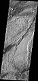 Southern end of Enipeus Vallis is about 10 km wide and broadly U-shaped in profile. The western wall of the valley has a straight NE orientation similar to that of fractures in the Noachian plateau materials to the east. This suggests that the valley formed along pre-existing faults. (THEMIS VIS image)
 -
 Anastomosing channels in Enipeus Vallis at 35.9°N, 267.0E, as seen in HiRISE image.
 -
 Enipeus Vallis (right). Note inner channel, levee-like deposits, and streamlined bedforms. (THEMIS VIS image)
 -
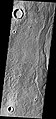
 Middle portion of Enipeus Vallis. The valley divides into several channels, forming large central island at 37.0°N, 267.2°E. Image is THEMIS VIS mosaic.


Notes
- ^ a b USGS Gazetteer of Planetary Nomenclature. http://planetarynames.wr.usgs.gov/Feature/1803.
- ^ a b c d e f Moore, H.J. (2001). Geologic Map of the Tempe-Mareotis Region of Mars. USGS Geologic Investigations Series I-2727. http://geopubs.wr.usgs.gov/i-map/i2727/.
- ^ Hartmann, W.K. (2005). Martian Cratering 8: Isochron Refinement and the Chronology of Mars. Icarus, 174, p. 317, Tbl. 3. doi:10.1016/j.icarus.2004.11.023.
- ^ Simpson, D.P. (1968). Cassell's New Latin Dictionary; Funk & Wagnalls: New York, p. 215.
- ^ USGS Gazetteer of Planetary Nomenclature. Descriptor Terms. http://planetarynames.wr.usgs.gov/DescriptorTerms.
- ^ Cite error: The named reference
Carr1was invoked but never defined (see the help page). - ^ Hynek, B.M.; Beach, M.; Hoke, M.R.T. (2010). Updated Global Map of Martian Valley Networks and Implications for Climate and Hydrologic Processes. J. Geophys. Res., 115, E09008, doi:10.1029/2009JE003548. Cited in Andrews‐Hanna, J. C.; Lewis, K.W. (2011). Early Mars Hydrology: 2. Hydrological Evolution in the Noachian and Hesperian Epochs. J. Geophys. Res., 116, E02007, Fig. 1. doi:10.1029/2010JE003709.
- ^ Carr, M. H., (2002). Elevations of Water-Worn Features on Mars: Implications for Circulation of Groundwater. J. Geophys. Res., 107(E12), p. 14-5, Fig. 3, doi:10.1029/2002JE001845.
- ^ Carr, M.H.; Clow, G.D. (1981). Martian Channels and Valleys: Their Characteristics, Distribution, and Age. Icarus, 48, p. 93.
- ^ a b Carr, M.H. (2006). The Surface of Mars; Cambridge University Press: Cambridge, UK, p. 113. ISBN 978-0-521-87201-0.
- ^ Boyce, J.M. (2008). The Smithsonian Book of Mars; Konecky & Konecky: Old Saybrook, CT, p. 163. ISBN 1-56852-714-4.
- ^ JMARS distance tool.
- ^ a b c JMARS gridded MOLA elevation dataset.
- ^ a b Carr, M.H. (1996). Water on Mars; Oxford, p. 47. ISBN 0-19-509938-9.
- ^ Baker, V.R.; Carr, M.H.; Gulick, V.C.; Williams, C.R.; Marley, M.S. (1992). Channels and Valley Networks in Mars, H.H. Kieffer et al. Eds.; University of Arizona Press: Tucson, 493-522.
- ^ Carr, M.H. (2006). The Surface of Mars; Cambridge University Press: Cambridge, UK, p. 122.
- ^ Head, J.W. (2007). The Geology of Mars: New Insights and Outstanding Questions in The Geology of Mars: Evidence from Earth-Based Analogs, M. Chapman, Ed.; Cambridge University Press: Cambridge: UK, p. 23. ISBN 978-521-83292-2.
- ^ Frey, H.; Roark, J.; Sakimoto, S; McGovern, P. (1999) The Crustal Dichotomy Boundary West of Tempe Terra: Speculation on Where It Lies Beneath Alba Patera Based on MOLA Topography. 30th Lunar and Planetary Science Conference, Abstract #1798. http://www.lpi.usra.edu/meetings/LPSC99/pdf/1798.pdf.
- ^ Greeley, R. (1977) Basaltic "Plains" Volcanism, Volcanism of the Eastern Snake River Plain, Idaho. NASA Contract. Report, CR-154621, 23–43 cited in Greeley, R.; Spudis, P. (1981). Volcanism on Mars. Rev. Geophys. Space Phys., 19(1), 13–41.
- ^ Plescia, J.B. (1981). The Tempe Volcanic Province of Mars and Comparisons with the Snake River Plains of Idaho. Icarus, 45, 586–601.
- ^ a b Moore, H.J. (1995). Geology of the Tempe-Mareotis Region, Mars. 26th Lunar and Planetary Science Conference, Abstract #1497. http://www.lpi.usra.edu/meetings/lpsc1995/pdf/1497.pdf.
- ^ Greeley, R. (1982). The Snake River Plain, Idaho: Representative of a New Category of Volcanism. J. Geophys. Res., 87(B4), 2705-2712, http://www.agu.org/pubs/crossref/1982/JB087iB04p02705.shtml.
References
- JMARS. http://jmars.asu.edu/. (See Christensen, P.; Gorelick, N.; Anwar, S.; Dickenshied, S.; Edwards, C.; Engle, E. (2007) "New Insights About Mars From the Creation and Analysis of Mars Global Datasets;" American Geophysical Union, Fall Meeting, abstract #P11E-01. http://adsabs.harvard.edu/abs/2007AGUFM.P11E..01C.)