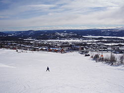
Beitostølen
Beitostølen | |
|---|---|
Village | |
 View of the village | |
| Coordinates: 61°14′55″N 8°54′22″E / 61.24865°N 8.90621°E | |
| Country | Norway |
| Region | Eastern Norway |
| County | Innlandet |
| District | Valdres |
| Municipality | Øystre Slidre Municipality |
| Area | |
| • Total | 1.06 km2 (0.41 sq mi) |
| Elevation | 893 m (2,930 ft) |
| Population (2021)[1] | |
| • Total | 358 |
| • Density | 338/km2 (880/sq mi) |
| Time zone | UTC+01:00 (CET) |
| • Summer (DST) | UTC+02:00 (CEST) |
| Post Code | 2953 Beitostølen |
Beitostølen is a village in Øystre Slidre Municipality in Innlandet county, Norway. The village is located at an elevation of about 900 meters (3,000 ft) above mean sea level on the southern edge of the Valdresflye mountain plateau. The villages of Skammestein and Hegge lie about 10 kilometres (6.2 mi) to the southeast of Beitostølen. The lake Øyangen lies a short distance to the southwest of the village. The Norwegian County Road 51 runs through the village.
The 1.06-square-kilometre (260-acre) village has a population (2021) of 358 and a population density of 338 inhabitants per square kilometre (880/sq mi).[1]
Sports
[edit]Beitostølen is largely a tourist area, with many holiday cabins and hotels serving various winter sports facilities. The village has hosted FIS Cross-Country World Cup and Biathlon World Cup competitions. Beitostølen is a year-round destination, and although the mountain village is best known to many as a winter sports destination due to its local alpine ski slopes, it also has cross-country skiing trails totaling 320 kilometres (200 mi). July is the month with the highest tourism rate due to hiking in the nearby Jotunheimen National Park to the north.[3]
References
[edit]- ^ a b c Statistisk sentralbyrå (1 January 2021). "Urban settlements. Population and area, by municipality".
- ^ "Beitostølen, Øystre Slidre". yr.no. Retrieved 13 August 2022.
- ^ "Beitostølen resort". Mountains of Norway. Retrieved 13 August 2022.


