Bąków, Kluczbork County
Appearance
Bąków | |
|---|---|
Village | |
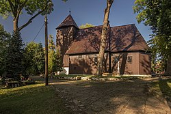
 Church of the Assumption in Bąków | |
| Coordinates: 50°58′N 18°19′E / 50.967°N 18.317°E | |
| Country | |
| Voivodeship | Opole |
| County | Kluczbork |
| Gmina | Kluczbork |
| First mentioned | 1258 |
| Population | 1,400 |
| Time zone | UTC+1 (CET) |
| • Summer (DST) | UTC+2 (CEST) |
| Vehicle registration | OKL |
| National roads | |
| Website | www.bakow.pl |
Bąków ([ˈbɔnkuf]; Template:Lang-szl, Template:Lang-de) is a village in the administrative district of Gmina Kluczbork, within Kluczbork County, Opole Voivodeship, in south-western Poland.[1] It lies approximately 8 kilometres (5 mi) east of Kluczbork and 43 km (27 mi) north-east of the regional capital Opole.
The village has a population of 1,400.
Sights
Heritage sites of Bąków include the old wooden Church of the Assumption and a historic palace.
Transport
There is a train station in Bąków. The Polish National road 11 passes through the village.
Notable residents
- Walter Scheunemann (26 March 1909 – 29 December 1949), Wehrmacht officer
- Otto Hoffmann von Waldau (1898–1943), Luftwaffe general
References


