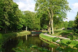
Canal d'Ille-et-Rance
| Canal d'Ille-et-Rance | |
|---|---|
 The Ille et Rance Canal in Chevaigné | |
| Specifications | |
| Length | 79 km (49 mi) [1] |
| Locks | 47 [1][2] |
| History | |
| Date of first use | 1832 |
| Geography | |
| Direction | North/South |
| Start point | Vilaine at Rennes [1] |
| End point | Dinan [1] |
The Canal d'Ille-et-Rance is a 79 km (49 mi) canal in northwestern France connecting Dinan to the Vilaine at Rennes in western France.[2]
See also
References
- ^ a b c d Jefferson, David (2009). Through the French Canals. Adlard Coles Nautical. p. 275. ISBN 978-1-4081-0381-4.
- ^ a b Vois Navigables France Itinéraires Fluviaux. Editions De L'Ecluse. 2009. ISBN 978-2-916919-21-8.
Wikimedia Commons has media related to Canal d'Ille-et-Rance.
