
Cape Kamui
Cape Kamui
神威岬 (Kamui misaki) | |
|---|---|
 Cape Kamui on the Shakotan Peninsula | |
 Cape Kamui | |
| Coordinates: 43°19′48.35″N 140°21′12.51″E / 43.3300972°N 140.3534750°E | |
| Location | Hokkaido, Japan |
| Offshore water bodies | Sea of Japan |
Cape Kamui (神威岬, Kamui misaki) is located on the western part of Shakotan, Hokkaido, Japan.[1] Its lighthouse, the Cape Kamui Lighthouse, overlooks the Sea of Japan. An earthquake off the cape on 2 August 1940 resulted in a tsunami that killed ten people.[2]
Gallery
-
 East bank
 -
 West bank
 -
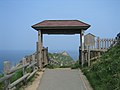 Entrance
 -
 Radio tower
 -
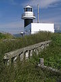 Cape Kamui Lighthouse


See also
References
- ^ "Tourism in Shakotan". Shakotan Town. Archived from the original on 10 February 2012. Retrieved 10 February 2012.
- ^ Kagami Hiroshi (2006). "1940.8.2神威岬沖地震の被害に関する文献調査(災害)". Journal of Architecture and Building Science. 24 (12). Architectural Institute of Japan: 457–460.
External links
![]() Media related to Cape Kamui at Wikimedia Commons
Media related to Cape Kamui at Wikimedia Commons
This Hokkaidō location article is a stub. You can help Wikipedia by expanding it. |