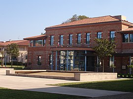
Castanet-Tolosan
Castanet-Tolosan | |
|---|---|
 Town hall | |
| Country | France |
| Region | Occitania |
| Department | Haute-Garonne |
| Arrondissement | Toulouse |
| Canton | Castanet-Tolosan |
| Intercommunality | Sicoval |
| Government | |
| • Mayor (2008–2014) | Arnaud Lafont |
| Area 1 | 8.22 km2 (3.17 sq mi) |
| Population (2008) | 10,821 |
| • Density | 1,300/km2 (3,400/sq mi) |
| Time zone | UTC+01:00 (CET) |
| • Summer (DST) | UTC+02:00 (CEST) |
| INSEE/Postal code | 31113 /31320 |
| Elevation | 145–281 m (476–922 ft) (avg. 164 m or 538 ft) |
| 1 French Land Register data, which excludes lakes, ponds, glaciers > 1 km2 (0.386 sq mi or 247 acres) and river estuaries. | |
Castanet-Tolosan is a commune in the Haute-Garonne department in southwestern France.
Population
| Year | Pop. | ±% |
|---|---|---|
| 1793 | 853 | — |
| 1800 | 848 | −0.6% |
| 1806 | 846 | −0.2% |
| 1821 | 977 | +15.5% |
| 1831 | 1,064 | +8.9% |
| 1836 | 1,120 | +5.3% |
| 1841 | 1,156 | +3.2% |
| 1846 | 1,157 | +0.1% |
| 1851 | 1,164 | +0.6% |
| 1856 | 1,120 | −3.8% |
| 1861 | 1,084 | −3.2% |
| 1866 | 1,050 | −3.1% |
| 1872 | 944 | −10.1% |
| 1876 | 915 | −3.1% |
| 1881 | 905 | −1.1% |
| 1886 | 903 | −0.2% |
| 1891 | 829 | −8.2% |
| 1896 | 848 | +2.3% |
| 1901 | 843 | −0.6% |
| 1906 | 766 | −9.1% |
| 1911 | 808 | +5.5% |
| 1921 | 744 | −7.9% |
| 1926 | 806 | +8.3% |
| 1931 | 872 | +8.2% |
| 1936 | 901 | +3.3% |
| 1946 | 1,002 | +11.2% |
| 1954 | 1,157 | +15.5% |
| 1962 | 1,544 | +33.4% |
| 1968 | 1,847 | +19.6% |
| 1975 | 2,996 | +62.2% |
| 1982 | 4,668 | +55.8% |
| 1990 | 7,697 | +64.9% |
| 1999 | 10,250 | +33.2% |
| 2008 | 10,821 | +5.6% |
See also
References
Wikimedia Commons has media related to Castanet-Tolosan.


