
Cerro Las Piñas
| Cerro Las Piñas | |
|---|---|
 | |
| Highest point | |
| Elevation | 2,425 ft (739 m) |
| Prominence | 764 ft (233 m) |
| Coordinates | 18°09′08″N 66°05′08″W / 18.1522°N 66.0855°W |
| Naming | |
| Etymology | "the pineapples hill" in Spanish |
| Geography | |
 | |
| Location | Caguas and Cayey |
| Parent range | Sierra de Cayey |
Cerro Las Piñas (Spanish for "pineapples hill") is a mountain of the Sierra de Cayey located in the boundary between the municipalities of Caguas and Cayey in central Puerto Rico. The summit is located at 2,425 feet (739 m) above sea level, in the barrios Beatriz of Caguas, and Beatriz and Guavate of Cayey. The summit offers panoramic views of the Valley of Caguas and Cayey.[1]
Gallery
-
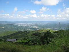 View of the Caguas Valley from the summit.

References
- ^ "Cerro Las Piñas". PeakVisor. Retrieved 2022-01-12.
This Puerto Rico–related article is a stub. You can help Wikipedia by expanding it. |