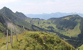
Col de Soladier
Appearance
| Col de Soladier | |
|---|---|
 | |
| Elevation | 1,576 m (5,171 ft)[1] |
| Location | Vaud, Switzerland |
| Range | Bernese Alps |
| Coordinates | 46°28′36″N 6°58′02″E / 46.47667°N 6.96722°E |
The col de Soladier (1,576 m or 5,171 ft) is a mountain pass in the canton de Vaud, in Switzerland. It is located 1 km west of a ridge linking the Vanil des Artses and the Cape au Moine, and east of Le Molard.

Toponymy
[edit]In vaudois dialect, its name is sor la diez, which means : on the spring.[2]
Activities
[edit]The col de Soladier is a popular destination for hiking, mountain biking, snowshoeing and ski touring. It is possible to reach the col de Jaman by using a small mountain trail.
See also
[edit]References
[edit]- ^ "SwissTopo Maps". SwissTopo. Retrieved 12 December 2014.
- ^ "Noms de lieux de Suisse romande, Savoie et environs (in French)". Retrieved 12 December 2014.

