
Coober Pedy
| Coober Pedy South Australia | |
|---|---|
 The town of Coober Pedy | |
 Coober Pedy | |
| Coordinates | 29°0′40″S 134°45′20″E / 29.01111°S 134.75556°E |
| Population | 1,916 |
| Postcode(s) | 5723 |
| Location | 846 km (526 mi) from Adelaide |
| LGA(s) | District Council of Coober Pedy |
| Federal division(s) | Grey |
Coober Pedy is a town in northern South Australia, 846 kilometres north of Adelaide on the Stuart Highway. At the 2006 census its population was 1,916 (1,084 males, 832 females, including 268 indigenous Australians).[1] The town is known as the opal capital of the world because of the quantity of precious opals that are mined there. It is also famous for most of the residents living below ground, mostly in old mines refurbished, due to the scorching daytime heat. The name 'Coober Pedy' comes from the local Aboriginal term kupa-piti, which means 'boys' waterhole'.[2]
Overview
Aboriginal people have a long-standing connection with the area. The first European to pass near the site of Coober Pedy was John McDouall Stuart in 1858, but the town was not established until after 1915, when opal was discovered by Willie Hutchinson.[3] Miners first moved in around about 1916. The harsh summer desert temperatures mean that many residents prefer to live in caves bored into the hillsides. A standard three-bedroom cave home with lounge, kitchen, and bathroom can be excavated out of the rock in the hillside for a similar price to a house on the surface. It remains at a constant temperature, whereas surface living needs air-conditioning, especially during the summer months, when temperatures often exceed 40 degrees Celsius (104 degrees Fahrenheit). The relative humidity rarely gets over 20% on these hot days, and the skies are usually cloud-free. The average maximum temperature is 30-32 degrees Celsius, but it can get quite cool in the winter.
Coober Pedy is a very small town, roughly halfway between Adelaide and Alice Springs, that has become a popular stopover point and tourist destination, especially since the completion of the sealing of the Stuart Highway in 1987
Interesting attractions in Coober Pedy include the mines, the graveyard, and the underground churches. The first tree ever seen in the town was welded together from scrap iron. It still sits on a hilltop overlooking the town. The local golf course - mostly played at night with glowing balls, to avoid daytime temperatures - is completely free of grass and golfers take a small piece of "turf" around to use for teeing off. As a result of correspondence between the two clubs the Coober Pedy golf club is the only club in the world to enjoy reciprocal rights at The Royal and Ancient Golf Club of St Andrews[citation needed].
Both the town and its hinterland, for different reasons, are very photogenic and have therefore attracted film makers. The town itself was the setting for the 2005 film Opal Dream. The hinterland, notably the Breakaways and Moon Plain, have featured as backdrops in films including Mad Max Beyond Thunderdome, Red Planet, Priscilla, Queen of the Desert, Pitch Black and Salute of the Jugger which made considerable use of locals as extras. Coober Pedy also featured in the second season of the TV series, The Amazing Race. The book Wildfire by Chris Ryan includes Coober Pedy but states that there are only 3 buildings on the surface and the rest of the town is underground. The music video for INXS's "Kiss The Dirt (Falling Down the Mountain)" was shot at Moon Plains. The town is a pivotal location in Wim Wenders' 1999 film Until the End of the World.[4][5]]
Climate
Coober Pedy has a desert climate (Köppen climate classification BWh).
| Climate data for Coober Pedy | |||||||||||||
|---|---|---|---|---|---|---|---|---|---|---|---|---|---|
| Month | Jan | Feb | Mar | Apr | May | Jun | Jul | Aug | Sep | Oct | Nov | Dec | Year |
| Source: Bureau of Meteorology[6] | |||||||||||||
Transport
The town is served by daily coach services from Adelaide. The Ghan serves the town through the Manguri Siding, 42km from Coober Pedy, which is served by trains twice weekly in each direction. Passengers on The Ghan are not usually allowed to disembark at Manguri unless they have prearranged transport due to the siding's isolation and the extremely cold temperatures at night.[7]
Coober Pedy is a gateway to the outback communities of Oodnadatta and William Creek, which are both located on the Oodnadatta Track. There is a twice-a-week mail run from Coober Pedy to these communities and other outback homesteads. It carries the mail, general freight and passengers[8].
Regional Express also have direct flights to Adelaide, from Coober Pedy Airport.
Template:Start GSR box Template:GSR line |}
Gallery
-
 An abandoned prop from the film Pitch Black
 -
 The Big Winch
 -
 An underground house display
 -
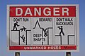 Warning sign at Coober Pedy


See also
References
- ^ Australian Bureau of Statistics (25 October 2007). "Coober Pedy (State Suburb)". 2006 Census QuickStats. Retrieved 2008-02-28.
- ^ Place Names of South Australia
- ^ Opal Capital of the World
- ^ Gluckman, Ron. "Home Under the Range". Ron Gluckman in Cyberspace. Retrieved 2008-12-21.
- ^ "Coober Pedy". RockWalk Park. Retrieved 2008-12-21.
- ^ "Cooper Pedy". Climate statistics for Australian locations. Bureau of Meteorology. Retrieved 2009-02-16.
- ^ Great Southern Railway, "Questions and Answers". Accessed 9 April, 2007.
- ^ "The Mail Run Tour".
External links
- Official website from The District Council of Coober Pedy & the Coober Pedy Retail Business & Tourism Association
- Photographs of Coober Pedy in 1994, National Library of Australia
- Coober Pedy
- Coober Pedy Travel Review
- Coober Pedy photos
- The Mail Run Tour
- Gigapixel Image of The Breakaways, Coober Pedy
- Megapixel Image of Coober Pedy from Stuart Highway