Cẩm Lệ district
Appearance
You can help expand this article with text translated from the corresponding article in Vietnamese. (March 2009) Click [show] for important translation instructions.
|
Cẩm Lệ District
Quận Cẩm Lệ | |
|---|---|
 Hòa Xuân Stadium in Cẩm Lệ District | |
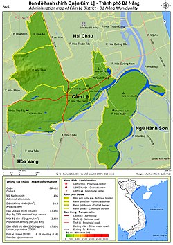
 Administration map of the district in Da Nang | |
| Country | |
| Region | South Central Coast |
| Municipality | Da Nang |
| Time zone | UTC+7 (Indochina Time) |
Cẩm Lệ is an urban district of Da Nang in the South Central Coast region of Vietnam.
Administration
The district was established by Government Decree No. 102/2005/ND-CP on August 5, 2005.
The district includes six urban wards (phường):
- Khuê Trung
- Hòa Thọ Đông
- Hòa Thọ Tây
- Hòa An
- Hòa Phát
- Hòa Xuân
As of 2003 the district had a population of 71,429.[1] The district covers an area of 33.3 km². The district capital lies at Hòa Thọ Đông ward.[1]
References
- ^ a b "Districts of Vietnam". Statoids. Retrieved March 20, 2009.
16°01′00″N 108°12′10″E / 16.01667°N 108.20278°E

