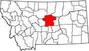
Danvers, Montana
Appearance
Danvers, Montana | |
|---|---|
 | |
| Country | United States |
| State | Montana |
| County | Fergus |
| Area | |
• Total | 0.27 sq mi (0.70 km2) |
| • Land | 0.27 sq mi (0.70 km2) |
| • Water | 0.00 sq mi (0.00 km2) |
| Population (2020) | |
• Total | 16 |
| • Density | 59.26/sq mi (22.89/km2) |
| FIPS code | 30-19225 |
| GNIS feature ID | 770453[2] |
Danvers is an unincorporated community in Fergus County, in the U.S. state of Montana.[3]
Nearby St. Wenceslaus Catholic Church is on the NRHP.
Demographics
| Census | Pop. | Note | %± |
|---|---|---|---|
| 2020 | 16 | — | |
| U.S. Decennial Census[4] | |||
History
A post office was established at Danvers in 1914, and remained in operation until it was discontinued in 1982.[5] The community took its name after Danvers, Massachusetts.[6]
References
- ^ "ArcGIS REST Services Directory". United States Census Bureau. Retrieved September 18, 2022.
- ^ U.S. Geological Survey Geographic Names Information System: 770453
- ^ U.S. Geological Survey Geographic Names Information System: Danvers, Montana
- ^ "Census of Population and Housing". Census.gov. Retrieved June 4, 2016.
- ^ U.S. Geological Survey Geographic Names Information System: Danvers Post Office (historical)
- ^ "Origins of Names on Milwaukee". Roundup Record-Tribune & Winnett Times. August 22, 1940. p. 6. Retrieved 27 April 2015.
47°13′31″N 109°43′02″W / 47.22528°N 109.71722°W

